This chapter details out the proposed planning interventions strategized to guide future development within the framework of envisioned goals and objectives for the NMA. These include:
Proposed land uses;
Social amenities and public facilities;
Transportation;
Water supply infrastructure;
Sewerage and drainage infrastructure;
Power supply infrastructure and
Solid waste disposal facility.
13.2The Proposed Land Use Plan
13.2.1 The Proposed Land Use Budget
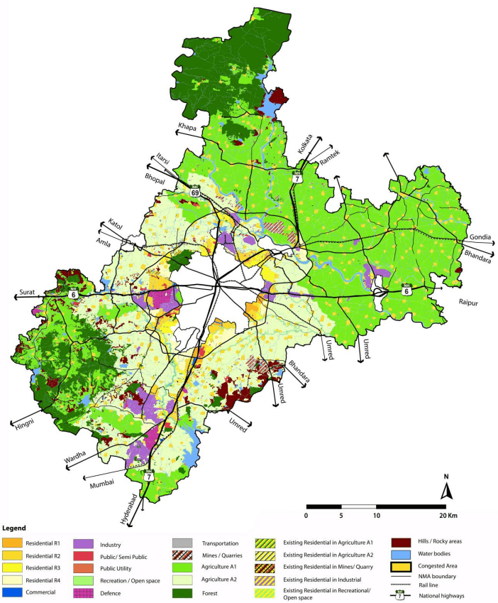
The structure plan and broad development policies discussed in chapter 11 form the base for the preparation of the proposed land use (PLU) plan. The PLU is shown in the Figure 13-1 and the areas under various land uses are given in the Table 13-1.
Table 13-1Areas under proposed land use zones
S. No.
Land use zone
Area (Sq km)
Percent of Urban land
Percent of Total area
1
Residential
381.81
50.53%
10.70%
2
Commercial
9.03
1.19%
0.24%
3
Industrial
101.20
13.39%
2.84%
4
Public-Semipublic
61
8.08%
1.71%
5
Public Utility
7.91
1.05%
0.22%
6
Recreation/Open space
67.98
9.00%
1.91%
7
Defense
23.64
3.13%
0.66%
8
Transportation
142.16
18.81%
3.99%
Subtotal Urban
755.64
100.00%
21.17%
9
Hills
108.62
3.04%
10
Mines/Quarries
28.49
0.80%
11
Agriculture
2007
56.26%
12
Forest
508.46
14.25%
13
Waterbodies
228.52
6.41%
Total Area
3,567.37
100.00%
It can be seen in the above table that about 755 km2 of land, which is about 21 percent of the total area of the NMA, is zoned under future urban uses.
13-1
13.3Proposed Land Use Zones
With a view to guide future development in the NMA, 13 land use zones are delineated. The land use zones form the basis for regulating activities and uses.
Mix of uses is a fundamental aspect of every urban land use zone (except in restricted zones such as Defence, Mines/ Quarries and Forests and so on). As described in Chapter 11, the benefits of mixed uses are multi-fold – it reduces dependence on automobiles, encourages walkability, lowers crime incidents and fosters greater opportunities for collaboration within communities.
Section 22 of the Development Control Regulations gives a detailed description of the uses permitted in each land use zone. Aspects that define each of these land use zones are given below.
Provisions of the sanctioned Regional Plan for Nagpur District 1991- 2011 has been considered while allocating land for urban uses. Chapter 6 of this Report presents a detailed assessment of existing land uses within the growth sectors demarcated in the Regional Plan. Based on the actual development on ground (market response) it was concluded that these areas have not witnessed growth as envisioned. Thus, there are certain deviations from the Regional Plan. These deviations have been recorded and presented in Annexure 19.
13.3.1Residential
About 381 km2land is zoned under residential use which covers about 50.53 percent of the total land zoned for urban uses within the NMA, and about 10.7 percent area of the NMA. In response to the idea of managing the rural-urban transect, this is further categorized into four zones – R1, R2, R3, and R4. The four residential zones support varying intensity and character of development depending upon what a particular area is most suitable for.
13.3.1.1 Residential R1
The Residential R1 zone is allocated to areas close to existing employment centres such as Nagpur City, MIHAN, Hingana, etc., which are already witnessing development activity. In terms of real estate demand these are the defacto areas to house future growth and thus allow for most intense development and higher mix of uses among all residential zones in the NMA including hotels and service industries with certain conditions/limitations. The gross average density in this zone is considered to be 55-35 dwellings per hectare (du/ha) or approximately 220 - 150 persons per hectare (pph). Amenities and facilities supporting residential uses are considered with these and generally includes commercial, open space etc.
Spatially the R1 zone is mainly located within the outer ring road, along the city boundary in areas that are relatively urbanized and are currently witnessing real estate development activity such as parts of Besa-Beltarodi, Kapsi-Khurd, Wadi and so on.
13.3.1.2 Residential R2
The residential R2 zone is intended to be characterized with relatively higher intensity development, but lower than R1. It will also allow a wide range of non-residential compatible uses resulting in a mixed-use character, including hotels and service industries with certain conditions/limitations. The gross average
13-2
density in this zone is considered to be around 35- 25 du/ha or approximately 150- 110 pph. R2 Zone is allocated to areas close to R1 Zone.
Figure 13-1: The Proposed Land Use Plan
13-3
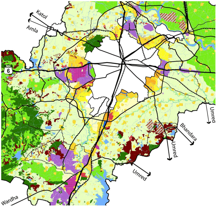
Figure 13-2: Proposed Land Use Plan - Urban Uses
13.3.1.3 Residential R3
The Residential R3 zone is intended to be developed with similar intensity as R2, but with fewer non-residential uses with a limitation on maximum permissible built-up area for certain commercial uses within mixed-use plots. Service industries are not permitted in this zone. The gross average density in this zone is considered to be around 25- 15 du/ha or approximately 110- 65 pph.
13-4
Within the outer ring road, the R3 zone is located in areas adjacent to R2 zone, in parts of Besa-Beltarodi etc., parts of Hingana near Hingana MIDC, parts along the north east of the city boundary along NH-7 (Kamptee road). Outside the outer ring road, land along the either side of the south corridor near Jamtha stadium and area north of Butibori industrial area is under R3 zone.
13.3.1.4 Residential R4
Areas which are currently rural in character, and in the future intended to support only low to very low density development, but which are in close proximity to other planned urban uses are zoned under R4. Thus intense commercial uses housed in mixed-use buildings along with residential use is not permitted. Other non-residential uses mainly comprise retail shopping, repair etc., which are essential for servicing the residential uses. Multi-storey apartments and shop line are not allowed in this zone. On the other hand, large format commercial developments (built-up area above 20,000 m2) that are not otherwise permitted in R2 and R3 zones are permitted in independent plots within the R4 zone. Agro-based cottage/ small scale industries registered with the DIC are also permitted in independent plots.
The gross average density is considered to be about 15- 10 du/ha or approximately 65- 45 pph. These areas are under least priority for being serviced with infrastructure and therefore development of a limited intensity is permitted in these location. Land parcels adjoining R2 and R3 zones but which lie on the rural side in areas such as: south-east and south-west of Nagpur city and some parts of north-west and northeast within the outer ring road, and along the south corridor are under R4 zone. Residential area south of Butibori industrial area is also zoned under R4 and so are residential areas within the rural centres.
13.3.1.5 Addressing the Future Need for Growth of Gaothans in Rural Areas
Out of all villages in the NMA, about 146 villages are included in urban sectors and rural centres (see Table 12-15). Based upon the assessment of demographic and socio-economic conditions, it is revealed that the remaining 574 villages have limited potential to grow or benefit from urban zoning. These are therefore intended to remain largely rural in character and continue supporting agriculture and allied uses. On the other hand the plan recognises the need for allowing future growth beyond the boundaries of the gaothans of these rural villages, mainly for residential purposes. Therefore areas upto 200 - 250m from the boundary of gaothans are zoned as Congested Areas. This zone is however not allocated in the 77 villages which are not inhabited (Rithi) as per the Census 2011.
Table 13-2Target densities and area allocated under each residential zone
S. No.
Residential Zone
Area (ha)
% land under residential zone
Average gross density Ppl/ ha*
1
Residential R1
2,116
5.87%
220- 150
2
Residential R2
5,393
60.71%
150- 110
3
Residential R3
4,646
12.88%
110- 65
4
Residential R4
7,408
20.54%
65- 45
5
Congested Area (Gaothans & gaothan expansion)
165,00
45.0%
Subtotal
36,064
100%
6
Existing residential outside Urban Sectors**
2,117
Total
38,180
*Gross density includes land under roads, open spaces and amenities/ utilities; ** Not target development areas
13-5
13.3.1.6 Non-conforming Residential Uses
Existing residential developments which are located in areas outside of the R1 to R4 zones are referred as non-conforming residential. For statistical purposes such non-conforming residential uses are also included in the residential zone. It is seen in the Table 13-2, that the area under R1 to R4 is 36,064 ha or 360.64 km2. Out of the total residential land 38,180 ha, balance land of 2,117 ha is under non-conforming residential use.
As long as such uses have valid development and building permissions, they will be allowed to continue in their existing density level (refer to section 5 of the Development Control Regulations). In the Development Plan, these are shown as ‘Residential in A1’, ‘Residential in A2’ and ‘Residential in Industrial’.
13.3.2Commercial
The general approach towards land use zoning is to encourage mix of compatible uses. Therefore regular retail and commercial development is permissible in residential zones. It is intended for land under commercial zone to allow exclusive development of large retail and specialized commercial uses like offices, hotels etc.
About 8.7 km2land is under commercial zone which represents about 1.15 percent of the land intended to be under urban uses. It should be noted that once development commences the actual area under commercial use will be much more as some commercial uses, with certain limitations, are allowed within residential zones. It is also proposed that residential built-up area in any plot within the commercial zone be restricted so that the envisioned character of commercial zone is maintained.
Pockets of land around key corridors in which commercial real estate activity is being witnessed such as areas in Besa in south-east, Wanadongri along Hingna road on the west, Umred road on south-east and along NH-7 near Bhilgaon, Khairy Yerkhada in the north. In terms of new commercial areas (where this activity is not predominant at present but will be newly introduced), portion of land near the VCA stadium at Jamtha and near Dongargaon station along the south corridor is zoned for this use.
13.3.3Industrial
Industries as employment hubs are zoned closer to the city and along major road corridors. Most of these are in existing established industrial areas such as Hingna, Butibori, Koradi-Khaparkheda and Mauda. Kapsi-Khurd on the east and Hingna on the west also have proposed industrial uses. About 13.39 percent urban land (and 2.84 percent of the overall NMA area) is under the industrial zone, which amounts to an area of about 101.20 km2.
Commercial uses such as offices, banks are allowed in the industrial zone. Limited residential uses can be developed in industrial plots, however high density typologies such as multi-storey apartments are not desired in proximity of industries and therefore restricted. On the other hand, housing for industrial workers is permitted with certain minimum requirements for access and safety.
13-6
13.3.5Open Space and Recreation
The approach taken to zoning land under the open space and recreation zone prioritizes on using the development plan to protect and preserve ecologically sensitive areas along rivers. A buffer of 100 m along the entire stretch of rivers Kanhan and Pench within the NMA, 50 m along rivers Vena, Nag, Sur, Sand and Bor has also been included under this zone.
Reservations for public open spaces as per the 1979 state government norms are included under this zone. Land allocations under reservations are described in further detail under 13.5, social amenities and public utilities. As far as possible land under this zone utilizes government owned parcels, but it is not uncommon to find private land zoned for such uses to meet the needs of future residential population.
About 68 km2, which is about 9 percent land under urban uses is under open space and recreation zone. All types of open spaces such as parks, gardens, playgrounds, landscaped/theme based gardens etc., are permitted as principle uses. Certain other uses which involve construction of buildings as accessory uses with limitations on total built-up area. Buildings within the river buffers will be designed and constructed as ‘low impact developments’.
13.3.4Public Semi-public
The public semi-public zone covers about 8.08 percent land under urban uses which amounts to about 61 km2. This includes existing government institutions, public and private social amenities and proposed reservations for schools, colleges, hospitals, etc., as public purpose facilities.
Land reservations for additional social amenities are proposed as per the 1976 State government norms. Reservations are provided for the resulting gap in provisions with respect to population for residential clusters based on the assumed residential densities. The provision of social amenities and public facilities is described in detail under 13.5, social amenities and public facilities.
13.3.6Agriculture
The agriculture zone comprises of the largest share – about 56 percent of the total land (2007 km2) within the NMA. A significant portion in this zone comprises of land with fertile soils under the irrigation command areas and is treated as ‘prime agriculture land’ which should be preserved. This zone is therefore further divided into two sub-zones – A1 for farmlands under the irrigation command areas and A2 for farmlands which are not irrigated at present. Of the total land under Agriculture, about 65 percent and 35 percent agricultural lands are zoned under A1 and A2 respectively. Limited non-agriculture uses are allowed in both zones; however the restrictions for development in A1 zone are relatively more stringent with regard to intensity of development and uses permitted.
13.3.7Public Utility
Land under the public utility zone is intended for locating essential utilities and services such as sewage treatment plants, elevated storage reservoirs, water works, electric sub-stations, cremation and burial grounds, solid water management and disposal site, solid waste transfer stations and so on. Each urban sector contains land allocations towards public utilities based on the established norms and standards. The existing public utilities are included in this zone along with proposed land reservations. Specific proposals
13-7
are described in detail further in this chapter. In all about 1.05 percent of the urban uses or 7.91 km2 area is allocated to this zone.
13.3.8 Transportation
The Transportation zone includes land under public road and rail right of ways, proposed bus depots, truck terminals and railway stations and so on. Specific transportation proposals are described in further detail in 13.5. About 18.81 percent land under urban uses is zoned under transportation.
13.3.9 Forest
Lands shown under the forest zone are under the ownership of the forest department. No development shall be permitted in this zone. A significant proportion of the NMA – about 14.25 percent of the total NMA area amounting to over 508.46 km2 is covered by the forest zone.
13.3.10 Defence
Land owned by the defence department covers over 3.13 percent of the total area under urban uses. Development within this zone shall be managed and regulated by norms set out by Ministry of Defence.
13.3.11Mines/Quarries
Area under mining and quarrying activity, which is about 0.80 percent of the total NMA area, is included in this zone. Mining and quarrying operations pose significant health risk to the residents of the NMA. As more and more areas undergo urbanization, such activities are likely to impact health of increasing number of people. As the Plan distributes majority of future population growth within the Outer Ring Road, it is proposed that the existing quarries in this area be converted into quarry parks at the end of the current license period. The PLU indicates specific sites to be converted as quarry parks. Existing quarries and mines located in areas beyond the Outer Ring Road are retained. As a policy it is recommended that new mining and quarrying activities should be limited and subject to stringent norms (See Regulation 41 of the Development Control Regulations).
13.5Transportation
Transportation proposals for the NMA mainly cover the following:
Road network
Truck terminals and parking areas
Public parking
Public transportation and related facilities
Upgraded railway stations
13.5.1 Road Network
The road network has been developed based on the road master plan 2020 for Nagpur district and the principles of the urban-rural transect. Primarily two main categories of roads are proposed:
Regional roads (carrying regional traffic)
Roads within the Urban Sectors
The overall land development strategy focuses on growth largely within the outer ring road and the southern corridor. The nature of land use in the NMA is unique as it spreads across varied landscapes which transition from forests and farmlands to urban areas. The transport network has been developed based on this transition. It is considered that all roads in the road network plan will be developed to the complete right of way.
The road network follows a ring radial pattern with major radials emanating from the city. The important radials are the NH-69 (Nagpur -Bhopal), NH-7 (Varanasi to Trivandrum) and NH-6 (Surat to Kolkata). The other important radials include the MSH-9 (Napur to Umred), Hingna road (Nagpur to Hingna through Raipur) and the Nagpur Fetari road. The area to the north of Nagpur city (Nagpur Rural, Saoner, Kamptee and Parshioni tehsils) has high several radials with few links connecting them. In order to facilitate local traffic movement across the major radials, it is proposed to build new connections between the radials and strengthen the existing ones. It is also proposed to strengthen the major radials by increasing the road right of way from their current widths to accommodate heavy traffic movement. The proposed road right of ways (RoW) are given in the Table 13-5.
Table 13-5Proposed right of ways and functional classification
S No
Road Width
Functional Classification
1.
60/80m
National Highway/ Outer Ring Road
2.
36m
Arterial
3.
30m
Arterial
4.
24m
Collector
5.
18m
Local
6.
12m
Local
13-17
13.5.2 Strengthening the Regional Road Network
The density of the network has been proposed based on the intensity of urban development that the plan envisages. The plan discourages the development of higher number of roads in the ecologically sensitive areas like forests. Except for national corridors like the national highways, it is proposed to keep the density of network at a broader grid size of about 10-15 km near environmentally sensitive areas. For arterial roads (36 m and 30 m) apart from the NH radials, a grid distance of 10-12 km is maintained. A grid distance of about 5-6 km is maintained near forest areas and 2-3 km near the city for all collector roads (24 m). The lower order local roads with a RoW of 18 m and 12 m (within the planning sectors) are proposed for lower traffic dispersion from the arterials and the collectors. In the area south west of the NMA in Hingna tehsil, due to the presence of a large number of reserved forests, only local roads with a RoW of 18 m are proposed to discourage heavy traffic flow from these areas.
Table 13-9 gives the total length of the proposed road network along with the breakup of the new links, upgraded links and already upgraded links. The total length of new links proposed to be developed at regional level is about 650 km. A summary of proposed regional road links is given in Table 13-6. National highways and Outer Ring Road which have right of way of 60m and above are given in Table 13-7.
Table 13-6Regional roads (outside Urban Sectors)
Sr No
Project Type
Length (Km)
Percent Total Length
1
Existing roads
242.54
8%
2
New links
485.93
19%
3
Proposed road widening Total
2,111.933,198.75
73%100%
Note: Extensive field visits indicate that in many locations existing ROW is seen on the ground however this is not a constructed road. Such roads form a significant part of (3) ’proposed road widening’ in the table above.
Table 13-7Regional roads – National Highways and Outer Ring Road
Sr No
Road Type
Length (Km) Percent Total Length
1
Existing National Highways with 60m wide ROW
2.83
2
Existing Outer Ring Road
65.02
3
Proposed Widening of NH upto 60m
193.05
4
Proposed Outer Ring Road Total
43.68304.57
13.5.3 Road Network in Urban Sectors
The road network within the urban sectors has been developed at approximate 500 m grid for both the collector and the local roads. A total of 899.6 km roads are proposed within the urban sectors. These roads also include some regional roads passing through the sectors.
13-18
Table 13-8Roads within Urban Sectors
Sr No
Road Type
Length (Km)
Percent Total Length
1
Existing Roads
70.48
8%
2
Proposed new links
380.70
42%
3
Proposed Road widening Total
448.43899.62
50%100%
Roads proposed in Urban Sectors support regional roads for traffic dispersion within Sectors. Road widths within the Sectors are defined at 24 m to 18 m and further down to 12 m wide RoW with functional classification of collector and local roads.
13.5.4 Functional Classification of Roads
The Table 13-9 indicates functional classification of roads in the NMA.
Table 13-9Classification of road network under MDR, ODR and SH
S. No.
Road Category
Right of way (ROW)
1
National Highway (NH)
18 m Bridge
2
60 m wide road
3
State Highway (SH)
12 m Bridge
4
18 m Bridge
5
18 m wide road
6
24 m wide road
7
30 m wide road
8
36 m wide road
9
Major District Road (MDR)
12 m Bridge
10
18 m Bridge
11
24 m Bridge
12
18 m wide road
13
24 m wide road
14
30 m wide road
15
36 m wide road
16
60 m wide road
17
Other District Road (ODR)
12 m Bridge
18
12 m wide road
19
18 m wide road
20
24 m wide road
21
30 m wide road
22
Outer Ring Road (ODR Built)
60 m wide road
23
National Highways
60 m wide road
13-19
13.5.5 Enhancing Access for Non-Motorised Transport
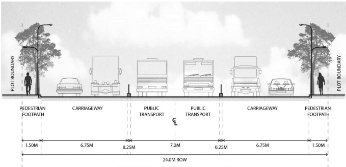
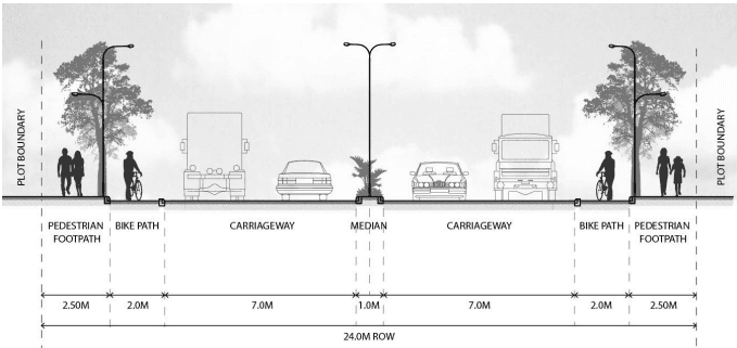
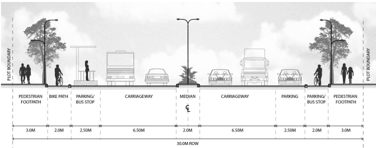
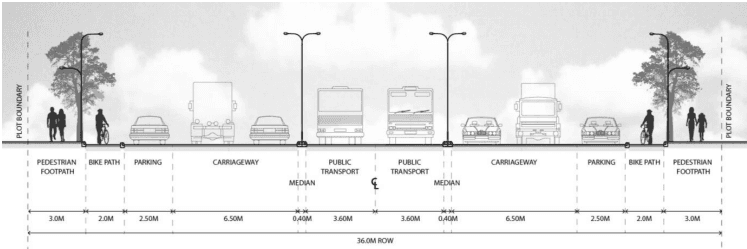
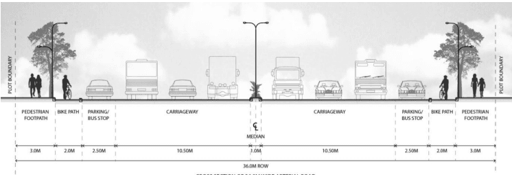
The Plan emphasises on mobility and enhanced access by ensuring that new investments in road infrastructure also cater to the needs of non-motorised transport modes, primarily pedestrians and cyclists. This is demonstrated through design of road right of ways that provide sufficient space for sidewalks and bicycle lanes. It is proposed that each type of road right of way includes sidewalks and bicycle lanes that are shaded by trees and provided street lights. Promoting walkable urban environments is one of the policy tools outlined in order to achieve one of the planning framework goals for the NMA – development and integration of urban systems (see Chapter 11, 11.2.3).
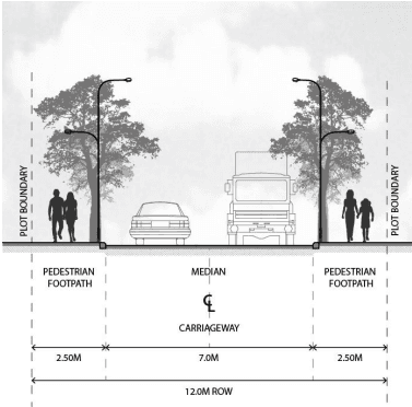
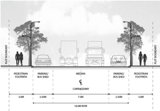
The proposed road cross sections are given in Figure 13-3.
13-20
CROSS SECTION OF 12.0M WIDE LOCAL ROAD
Figure 13-3: Road Cross Sections
CROSS SECTION OF 18.0M WIDE LOCAL ROAD
13-21
CROSS SECTION OF 24.0M WIDE COLLECTOR ROAD
CROSS SECTION OF 24.0M WIDE COLLECTOR ROAD
13-22
CROSS SECTION OF 30.0M WIDE ARTERIAL ROAD
CROSS SECTION OF 36.0M WIDE ARTERIAL ROAD
CROSS SECTION OF 36.0M WIDE ARTERIAL ROAD
13-23
13.5.6 Truck Terminals
As described in Chapter 10, the logistical advantages of Nagpur have given rise to an urgent need for designating adequate areas for parking heavy transport vehicles at appropriate locations in the NMA. Reservations for truck terminals are therefore proposed at total 12 locations in the NMA.
Table 13-10 gives details regarding locations and area of each proposed facility. A total of 150.03 hectare land is reserved for truck parking.
Table 13-10Proposed reservations for truck parking areas
S No Village
Area (ha)
Sector
Tehsil
1. Dahegaon (Rangari)
5.9
North A
Saoner
2. Kandri
20.3
North B
Parsheoni
3. Vihirgaon
1.8
East A
Nagpur Rural
4. Ranala, Bhilgaon
8.44
East B
Kamptee
5. Ranala
8.1
East B
Kamptee
6. Bhilgaon, Khairi
14.7
East B
Kamptee
7. Parsodi (G)
23.29
South A
Nagpur Rural
8. Hingna
4.5
West A
Hingna
9. Kadholi
10.02
Outside sector
Kamptee
10. Kadholi
25.57
Outside sector
Kamptee
11. Mohgaon (Kh)
1.77
Outside sector
Nagpur Rural
Total
124.41
13.5.7 Parking for Private Vehicles
Public parking facilities are proposed on eight sites which are located within the commercial zone (see Table 13-11). A total of 6.0 hectare is reserved for public parking lots or garages.
Table 13-11Proposed reservations for parking area for private vehicles
S No
Village
Area (ha)
Sector
Tehsil
1.
Gonhi (Kh)
0.71
East A
Nagpur Rural
2.
Tarodi (Kh)
0.98
East A
Kamptee
3.
Khairi
1.06
East B
Kamptee
4.
Jamtha
0.91
South A
Nagpur Rural
5.
Besa
0.68
South B
Nagpur Rural
6.
Besa
0.56
South B
Nagpur Rural
7.
Wanadongri
0.67
West A
Hingna
8.
Suraburdi Total
0.416.0
West A
Nagpur Rural
13-24
13.5.8 Public Transportation
13.5.8.1 Bus Depots
Reservations for bus depots are proposed at two locations; one each in sectors South A and West A (see Table 13-12). A total of about 7.69 hectare land is reserved for two bus depots.
Table 13-12Proposed reservations for bus depots
S No
Village
Area (ha)
Sector
Tehsil
1.
Parsodi (G)
3.53
South A
Nagpur Rural
2.
Waddhamana Total
4.167.69
West A
Hingna
13.5.8.2 Public Transport Network
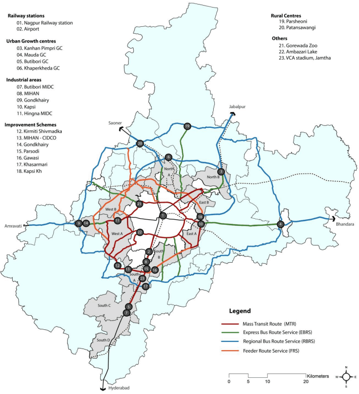
In order to ensure sustainable mobility and access in the long term, the road network needs to be complimented with a suitable public transportation system. Taking cognizance of this, identification of routes that would connect the existing and proposed employment centres, areas planned for higher residential densities and key commercial zones has been done. The length of this route is approximately 858 km running along roads of varying right of ways (See Table 13-13). This is a broad proposal and further detailed studies will have to be conducted to estimate ridership, suitable modes and route alignments. The route can be categorised into four types depending upon the estimated frequency of trips and ridership on different segments (See The Express Bus Route is delineated such that key junctions on the Mass Transit Route can be connected to destinations located relatively farther from the envisaged urban areas – such as Kalmeshwar Council, Mauda Nagar Panchayat and so on. The Regional Bus Route can run parallel to the Outer Ring Road and connect key rural centres. Dedicated road right of ways are not available on either of these, however the service frequencies would be higher on the Express Bus Route. Intermediate feeder services such as shuttle or para transit can run on Feeder Route or on other key roads which connect to the three types of transit routes named above.
Figure 13-4).
Table 13-13Proposed public transit routes
S No
Route type
Length
1.
Mass transit route (MRT)*
214.68
2.
Express bus route (EBR)
290.23
3.
Feeder route (FR)
59.28
4.
Regional bus route(RBR) Total
293.11857.30
The Mass Transit Route can be the primary transit spine line that can potentially connect to the proposed Nagpur City Metro. The road right of ways are planned with the consideration of dedicated carriageway width to serve transit. It is proposed that the Ngapur City metro rail, which is currently under implementation, should be extending from MIHAN to Butibori on the southern corridor. In future, other
13-25
routes identified can be serviced by Bus Rapid Transit (BRT) or metro depending upon the estimated ridership and demand in the future.
The Express Bus Route is delineated such that key junctions on the Mass Transit Route can be connected to destinations located relatively farther from the envisaged urban areas – such as Kalmeshwar Council, Mauda Nagar Panchayat and so on. The Regional Bus Route can run parallel to the Outer Ring Road and connect key rural centres. Dedicated road right of ways are not available on either of these, however the service frequencies would be higher on the Express Bus Route. Intermediate feeder services such as shuttle or para transit can run on Feeder Route or on other key roads which connect to the three types of transit routes named above.
13-26
Figure 13-4: Schematic public transit routes
13-27
13.5.8.3 Strengthening the railway logistics infrastructure and passenger terminal facilities
As described in Chapter 7, 7.2, the existing network of the Central Railway and South Eastern Railway traverses across the NMA. The Central Railway development plan has proposed expansion of freight handling capacities through construction of additional lines for the proposed Dedicated Freight Corridor project. The proposed upgrade of Nagpur City railway station will also require the logistics related function to be shifted to other suburban locations. In view of the above, areas around Gumgaon and Bharatwada stations on existing broad gauge links have been delineated under the Transportation Zone.
Although Butibori is one of key industrial centres in the NMA, there is limited scope for expansion of Butibori station as the surrounding area is already developed. Dongargaon, near Gumgaon station, is strategically located between MIHAN and Butibori. The other regional amenities such as the existing stadium at Jamtha and the proposal for Convention/ Exhibition Centre under this Development Plan are in close proximity of Dongargaon. It is therefore the preferred location as a future transportation and logistics hub along the south corridor.
The existing Bharatwada station is located along the north western broad gauge rail line towards Itarsi-Gwalior. Need for a rail logistics hub has arisen in this area mainly due to limited scope of expansion for the Kalmeshwar goods shed. Moreover, its location on the Outer Ring Road makes it suitable as multi-modal logistics centre.
13.7Sewerage Disposal
13.7.1 Estimation of Sewage Generation
The estimated sewage generation is quantified at 80 percent of the estimated water demand. Table 13-22 indicates the capacities of STPs in each urban sector and the corresponding land reservations proposals. In all it is estimated that about 158 MLD sewage will be generated in the urban sectors.
Table 13-22Sewage generation in urban sectors
S No
Urban Sector
Water Demand (MLD)
Capacities of STPs (MLD)
1.
East A
18.85
15.08
2.
East B
13.03
10.43
3.
North A
24.40
19.52
4.
North B
13.38
10.70
5.
South A
22.63
18.10
6.
South B
15.05
12.04
7.
South C
13.06
10.45
8.
South D
11.78
9.42
9.
West A
52.03
41.63
10.
West B Total
13.25197.46
10.60157.97
13.7.2 Sewerage Proposals
Decentralised sewage treatment plants (STP) based on the sequential batch reactor (SBR) technology are proposed in all Urban Sectors. Table 13-23 gives details of land required for STPs in each sector.
Table 13-23Provision of sewage treatment plants
S No
Urban Sector
Provision for STPs (number)
Land Reserved for STPs (ha)
1.
East A
2
1.72
2.
East B
2
3.98
3.
North A
1
1.45
4.
North B
1
0.81
5.
South A
1
1.33
6.
South B
1
1.39
7.
South C
0
0.00
8.
South D
1
0.82
9.
West A
1
3.01
10.
West B Total
11
0.740.34
Area covered by Urban Sectors is considered for estimating the length for sewerage collection network in sectors. The total area covered by Urban Sectors is 60,500 hectare.
13-36
13.6Water supply
13.6.1 Background
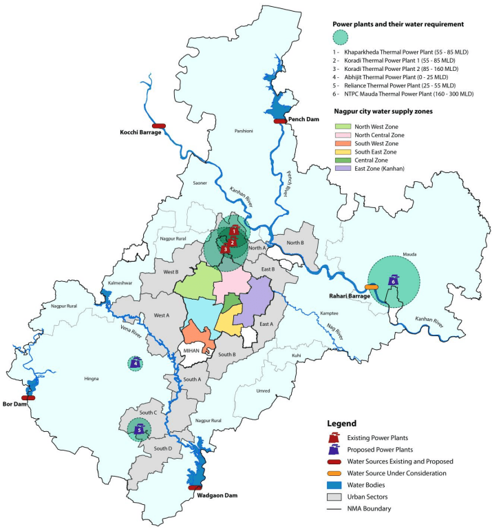
The NMA is drained by three major rivers, namely the Pench, Kanhan and Vena. About 70 percent of land drains into the Kanhan River. The main source of water for irrigation as well as potable water consumption is the Pench dam on Pench River which is a tributary of Kanhan. The other prominent water bodies and lakes in the NMA include Wadagaon, Wakeshwar, Tehlara, and Kanholibara lakes which also act as a source for medium to minor irrigation projects.
While the NMA and Nagpur city are separate jurisdictions of planning authorities, the two areas are intertwined in terms of resources, physical and social infrastructure and overall identity. The urban areas in the NMA are relatively newly developed and are an outcome of expanding urban activities within the city, particularly employment centres and regional infrastructure facilities such as power plants. Servicing new areas of growth in the NMA and provisioning cost-effective and operationally efficient infrastructure systems in the long term will require collaboration between the two jurisdictions, the irrigation department and power plant operators. This is only a reflection of the challenges presented by rapid urbanisation and availability of limited water resources in all parts of the country. Partnership for efficient management of water resources is thus a critical need of the hour not only across municipal but district and state boundaries.
Given this background and with a view to holistic manage water supply provision in the NMA and Nagpur city over the next two decades the plan proposes employing the water swapping concept. This would involve substituting bulk raw water currently used for industrial purposes with recycled water, thus saving this precious resource for potable needs of future residents of the NMA.
13-28
13.6.2 Demand Estimation for Urban Sectors in the NMA
Estimation of water demand is made as per requirements of the projected population for 15 year period (year 2027). As per the overall plan strategy only the urban sectors which cover an area of about 600 km2 (600,000 hectare) will be serviced with infrastructure. Based on this framework the estimated water demand for various activities in the NMA is given in Table 13-14 and Table 13-15 below.
Table 13-14Estimated water demand in urban sectors
S No
Urban Sector
Population
Water Demand (mld)
1.
East A
91,600
18.85
2.
East B
63,000
13.03
3.
North A
95,900
24.40
4.
North B
65,000
13.38
5.
South A
109,500
22.63
6.
South B
73,000
15.05
7.
South C
63,000
13.06
8.
South D
57,000
11.78
9.
West A
251,000
52.03
10.
West B Total
64,000933,000
13.25197.46
The water demand for South A sector considers the population allocated to the MIHAN Improvement Scheme.
Table 13-15Estimated water demand for industrial use
S No
Description
Area (hectare)
Water Requirement
Water Demand (mld)
1.
Area under industries
4,000
45,000
180
The total water demand for urban uses by the year 2027 is estimated to be about 377 MLD.
13.6.3 Reducing Fresh Water Requirement through Recycle and Reuse - Long Term Strategy
Industries and particularly thermal power plants can consume recycled water for a significant proportion of their demand. Thermal power plants can utilize treated waste water produced after tertiary treatment for ash handling and cooling tower applications that amount to about 80 percent of the total water requirement. The first step is to thus assess the potential to reduce need for drawing fresh raw water for industrial consumption.
At present three thermal power plants owned by public agencies and two by private companies are operational in the NMA. Further, two new plants and expansion of the existing privately operated plants is proposed. Thermal power plants have massive water requirements thus making them key consumers. The total water demand for or power plants (existing and proposed) is given in the Table 13-16.
13-29
Table 13-16Water demand for power plants in the NMA
S No
Existing and Proposed Power Stations
Water Demand (mld)
Source
Potential for Recycled Water
Remarks
1.
Koradi and Khaparkheda - existing
151.0
Pench
120.8
110 mld recycled water to be sourced from NMC
2.
Koradi and Khaparkheda - proposed
156.6
Pench⁷ (Partial)
125.3
-
3.
NTPC, Mauda (I & II)
270.0
Gosikhurd Dam
216.0
-
4.
NTPC, Mauda (expansion)
Gosikhurd Dam
-
5.
MADC , MIHAN (not fully operational)
22.6
Vadgaon Reservoir⁸
18.0
-
6.
Reliance, Butibori*
55.0
Vadgaon Reservoir⁹
44.0
-
Total
655.2
525.0
-
*Note: 22.6 MLD for 246 MW TPS has been taken as a base calculation for estimating the water requirement for NTPC and Butibori TPS
The combined future water demand of all power plants is about 655 MLD. Of this total requirement, about 525 MLD can be consumed from recycled water. At present this demand is met only through fresh water from Pench, Gosikhurd dam and Vadgaon reservoir. As per an agreement between NMC and MSPGCL, about 110 MLD recycled water will be supplied to Koradi and Khaparkheda power plants. Thus, requirement of about 415 MLD water for other power plants can still be catered by recycled water in the future.
13.6.4 Sourcing Water for the NMA in the Medium Term
As discussed earlier, Pench River and Kanhan River are the key water sources for Nagpur city and areas within the NMA. The Pench River has a number of projects constructed on its course, the key projects being Nave Gaon Kheri dam and the Totla dam. Two projects have also been proposed on the Kanhan River, namely Kochi barrage and the Rahari barrage.
13-31
The Rahari barrage scheme was proposed scheme near Rahari village in Mauda tehsil for supplying water to Nagpur city, however it was abandoned by the NMC due to non-availability of funds. It is proposed that the Rahari barrage project is completed for supplying water to the surrounding farmlands, currently irrigated by Pench. The water thus released from Pench can then be utilized for potable needs of the NMA. The capacity of Rahari barrage is about 160 MLD, which can cater to about 80 percent of the estimated domestic water demand of urban sectors.
13.6.5 Sourcing Water for the NMA in the Short-Term
The water swapping proposal for power plants will take a few years to be implemented and it is therefore necessary to identify an interim source of water for the early stages of development in the NMA.
The Nagpur city projected population for year 2011 is less than the actual population as per census 2011. Table 13-19 gives the difference in projected and actual population and corresponding water demands.
Table 13-19Water availability in the short term
Description
2011
2011Requirement@ 150 LPCD
2021
2021Requirement@ 150 LPCD
2027
2027Requirement@ 150 LPCD
Nagpur city population as per DPR for Nagpur city water supply scheme Pench-IV
28,30,000
424.5 MLD
36,90,000
553.5 MLD
47,50,000
712.5
Nagpur city population as per Census 2011
24,05,421
360 MLD
-
-
-
-
Nagpur city projected population as per the Cohort survival projection method
24,05,421
360 MLD
30,16,882
453 MLD
37,59,571
564 MLD
Difference
4,24,579
64.5 MLD
6,73,118
100.5 MLD
9,90,429
148.5 MLD
It is seen in the table above that as per current provisions for Nagpur city surplus water of approximately 60 MLD to 65 MLD can be available for immediate needs of the NMA. This can cater to about 4 lakh people in the NMA or about 30 percent of the estimated water demand of urban sectors.
13.6.6 Summary of Water Supply Source Identification
In summary, long term, medium term and short term strategies are outlined to cater to the water requirement of the NMA:
The short term (upto 5 years) strategy is to use the excess provision for Nagpur city for supply to the NMA in the initial development stages.
13-32
The medium term strategy is to undertake the Rahari barrage scheme which can supply water for irrigation so that water from Pench, which is currently allocated for irrigation, can be supplied for the NMA.
The long term strategy calls for swapping fresh water intake by power plants from Pench, Gosikhurd dam and Vadgaon reservoirs with recycled water from sewage generated in the NMC. Also industrial areas in the NMA will be supplied recycled water from the nearby STPs. The fresh water thus saved will be supplied to NMA.
The water swapping mechanism is proposed with a view to take a sustainable approach towards overall water management within the NMA and Nagpur city in the future. The findings and calculations presented are schematic and a detailed feasibility study should be undertaken along with close consultations involving all agencies involved.
13-33
Figure 13-5: Water supply source identification
13.6.7 Water Supply Proposals
13.6.7.1 Capacity Augmentation of the Mahadula Water Treatment Plant (Pench 4)
The NMC has undertaken construction of the second water treatment plant (WTP) in Nagpur city at Mahadula (Pench 4 scheme). The total capacity of this facility is 115 MLD and the treated water is allocated towards needs of Nagpur city until 2031. Preliminary assessment has revealed that excess land is available at this site. It is proposed that the additional treatment capacity of about 197.46 MLD required to supply
13-34
water to the NMA be achieved by expanding this facility. A detailed feasibility and detailed design study will have to be carried out.
13.6.7.2 Expanding the Water Supply Distribution Network to the 10 Urban Sectors
Land reservations for elevated storage reservoirs (ESR) have been made in all sectors. As given in Table 13-20, ESRs in all are proposed in the 10 urban sectors, covering an area of 163 hectare.
Table 13-20Provision for elevated storage reservoirs in urban sectors
13.4Reservations for Social Amenities and Public Facilities
The overall quality of life in an urban area is largely determined by the availability and level of access to social infrastructure and public utilities. While planning and envisioning new residential communities, public amenities are planned and distributed in a manner that prioritizes access to these facilities. In order to protect the interests of the community as a whole, land reservations for social amenities are proposed as part of the development plan for the NMA.
13.4.1 Norms and Standards Adopted
As discussed in the Chapter 12, 12.2, provisions have been made for social and physical infrastructure for a projected population for 15 years period (year 2027). Reservations have been proposed for the following categories:
13‐8
Educational Complex: Primary, secondary, or integrated k‐12 Schools, higher education institutions or institutions imparting any level of education
Open space/ recreation: Gardens, playgrounds, regional parks, sports complex
Social amenities and facilities: Community centres (includes library, multipurpose hall or auditorium) fire stations, cremation/ burial grounds, vegetable markets, police stations
Commercial: Commercial centre/ shopping centre
Public utilities: Elevated/ground storage reservoirs, sewage treatment plant, electric sub‐stations, solid waste disposal sites, slaughter house
Transportation: Bus terminal, truck terminal, public parking
Special reservations: District court complex, jail, exhibition centre
In response to the recommendation by the Town Planning Department, Maharashtra State, standards for provision of amenities are based on the state government norms, 1979 (1979 GR) and are given in the Table 13‐3. Norms for such amenities not specified in 1979 GR are referenced from Delhi Master Plan 2020. The provisions for public utilities infrastructure (water supply, sewerage) are based on CPHEEO norms and are discussed under 13.6 and 13.7.
Table 13‐3: Standards for provision of social amenities and public facilities
S No
Type of amenity
Standard followed
Source
Reservation detail
No. of units
Unit area
Area per unit
Reference for unit size
1.
Education complex – 1
15% population; Minimum 1 school per 500 students
Per student: 5sqm built and 3m² playground;
1979 GR
0.4 hectare
8 m2 X 500 = 4,000 m2 = 0.4 hectare
2.
Education complex – 12
7.5% population; Minimum 1 school per 750-1000 students
Per student: 4m² built and 11m² playground;
1979 GR
1.125 hectare
15 m2 X 750 = 11,250 m2 = 1.125 hectare
3.
Medical Facility
1 per 10,000 people
0.25 hectare per 10,000 people
1979 GR
0.25 hectare is for a Dispensary and Maternity Home.1 hectare is reserved for an intermediate hospital.
Intermediate Hospital size taken from UDPFI
13‐9
S No
Type of amenity
Standard followed
Source
Reservation detail
No. of units
Unit area
Area per unit
Reference for unit size
4.
Parks/ Gardens
0.2 hectare per 1,000 people
1979 GR
10 hectare for regional parkOther Parks of sizes ranging from 1-5 hectare
10 ha regional park as per 1979 GR for 50,000 population.
5.
Play Grounds
0.4 hectare per 1,000 people
1979 GR and for sports complex - recent examples of similar facilities
20 hectare for sports complexOther playgrounds ranging from 1-10 hectare
20 hectare sports complex - 1 ha - football field. 2 ha - cricket field
6.
Library
0.05 hectare for 10,000 people
1979 GR
0.2 hectare minimum
As per UDPFI, 2000 m2 area needed for library and community hall for 15,000 ppl
7.
Multipurpose hall, cultural centre etc.
0.5 hectare per 50,000 people
1979 GR
Varies
8.
Vegetable Market
0.2 hectare per 10,000 people
1979 GR
Varies
9.
Crematorium/ Burial Ground
Regional Requirement
Delhi Master Plan 2021
Minimum 0.25 hectare for each Cemetery & Burial Ground; 1 hectare per 10 lakh population
UDPFI specifies 2 sites per 5 lakh people
10.
Slaughter House
Regional Requirement
1979 GR
2 hectare
2 hectare given as flexible space.No area specified in any norms
11.
Fire Station
1 for 2 lakh people.
Regional Requirement
Delhi Master Plan 2021
1 hectare
Serving areas within radius of max 5-7 km
13‐10
13.4.2 Provision of Social Amenities and Public Facilities in Urban Sectors
The urban and rural areas have different demand for social amenities and the public facilities. Thus, the norms described in Table 13-3 are applied for urban sector areas and reservations are made according to them. Primarily, provision of amenities in urban sectors has been made at three levels:
o Local amenities like schools, medical facilities and open spaces;
o Regionally important facilities like regional park and sports complex which serve larger population;
o Special reservations such as exhibition grounds and district court complex
13.4.2.1 Educational
The reservations under education comprise of Education Complex -1 (intended at primary and secondary schools. As mentioned in chapter 9, there is a wide coverage for all categories of schools sufficing for existing population. Considering the increased residential densities proposed in R2 and R3 zoned urban areas, there is additional requirement for the same.. An extensive survey of existing schools was done and this information was compared to the projected requirement of schools by for projected population in each sector in year 2027. These facilities have been sited within existing and proposed residential areas. A total of 99 educational complexes are planned as part of this Development Plan.
13.4.2.2 Medical
The 1979 government regulations have listed dispensary/ maternity homes as reservation for health care facilities. It was observed that there is a requirement of intermediate hospitals (50-80 beds) which can cater to wider range of health facilities in urban areas. Thus the required area for health care facilities was divided into the two categories. There are 29 dispensaries/ maternity homes and 4 intermediate hospitals planned as part of this Development Plan.
13.4.2.3 Commercial
There are some specific areas zoned as commercial (see 13.3.2) and there are many commercial activities permitted within the residential zoned areas within the development plan (as detailed under 13.3.1.1, 13.3.1.2 and 13.3.1.3). In addition to this, there are four commercial centres planned at strategic locations within NMA (Sectors West A, East A and two sites in South A). They are envisioned to house commercial activities such as open air/ enclosed malls, local shopping, office complexes etc. and can eventually be the catalysts for development around them. Such centres are expected to provide parking areas.
13.4.2.4 Recreational
Various open spaces come under the recreational category of reservations. The two categories of local open spaces are the playgrounds and parks and gardens. Attempts are made to reserve areas even within the existing settlement areas in addition to the proposed development areas. In addition to these open spaces, regional parks are planned at edges of the urban areas connected by major arteries. Some of these reservations comprise of environmentally sensitive areas which are preserved simultaneously.
13.4.3 Public Facilities Located Outside Urban Sectors
Outside of urban sectors, the population is spread out in the remaining 575 villages of the NMA. The population residing in these individual villages will not be sufficient to provide the critical mass needed for provision, operation and maintenance of social amenities which are proposed for urban sectors. Farming is the primary occupation in the rural NMA and any land reservation will have a direct impact on the livelihoods of the rural land owners. Thus local needs of individual village communities should not be generalised at this stage. Therefore the provision of social amenities in rural areas is not based on population catchment norms but informed by specific requests that have been received from village communities or public agencies.
13.4.3.1 Cremation/Burial Grounds
It was assessed that a key requirement of rural villages is of cremation/ burial grounds; however provision of a separate reservation for each villages was not justifiable. Therefore this facility is proposed for clusters of five villages. This is over and above of the provision for separate sites requested by specific villages1. In all 34 sites are reserved for cremation/burial grounds outside of urban sectors.
13.4.3.2 Electric Sub-stations
Sites for electric sub-stations are reserved in villages based upon the requirements of the MSEDCL. Some of these sites are located outside of urban sectors. Details of this proposal are discussed in 13-10.
13.4.3.3 Special Reservations – Jail, District Court Complex, Exhibition/ Convention Centre and Multimodal Transport Hub
Site for locating a jail has been identified on an area spreading across 40 acres, which is intended to a state or national level facility. This site is located in villages Mahalgaon, Asoli and Dighori (Bk) of Kamptee tehsil.
1 Request was received by NIT for villages Parshioni, Suraburdi and Butibori. Butibori is included in sector South C therefore, separate reservations for cremation/ burial grounds are proposed in Parshioni and Suraburdi.
13-12
The District Court Complex is located in close proximity to the jail – in village Asoli, on a site of area about 8ha.
Three modes of transportation - rail, road and future public transit route offer high level of connectivity to the southern corridor. The multi-modal transport hub (MMTH) at Dongargaon (near Gumgaon) will act as a common junction for metro rail station, bus and an upgraded passenger railway station thus allowing intermodal transfers efficiently. This will enable easy access to the proposed convention and exhibition center from all the different transport modes. The adjoining commercial center will complement the transport hub and the proposed convention center. Together the three facilities will help in creation of a new regional mixed-use activity hub.
The potential of generating recycled water from sewage generated through non-industrial demand within the NMA is presented in the Table 13-17.
Table 13-17Potential for generation of recycled water by 2027
S No
Description
Non-Industrial Water Demand (MLD) (2027)
Sewage Generation (MLD) (2027)
Potential Recycled Water from Sewage (MLD)
Potential Recycled Water Available for Reuse (MLD)
Reuse of recycled water generated in the NMC: About 430 MLD recycled water can be potentially available from sewage generated in the NMC. At present the STP operational at Bhandewadi has a capacity of 80 MLD. The NMC has proposed another STP of capacity 130 MLD at Bhandewadi, which will supply treated water to the power plants in Koradi and Khaparkheda. As mentioned above, the MSPGCL (MahaGenco) has agreed to source 110 MLD of treated waste water from NMC. Thus remaining 320 MLD treated recycled water from NMC would be available for reuse in the future.
Reuse of recycled water generated in the NMA: Recycled water of about 118 MLD can be generated from non-industrial uses which can cater to partial requirement (65 percent) of new industries in the NMA itself. This would reduce the requirement of fresh raw water for the NMA to about 174 MLD for non-industrial uses and 62 MLD for industrial uses – A total of 236 MLD.
In summary, by 2027, the 320 MLD recycled water from NMC can be fully reused by power plants. Thus 320 MLD of raw water, which would otherwise be used by the power plants, can be made available for potable uses of the future residents of NMA. However the need would be for only 236 MLD, resulting into raw water surplus of about 84 MLD. Table 13-18 summarizes the sources of recycled and raw water for power plants and future uses in the NMA.
Table 13-18Summary of recycled and fresh water use in the NMA
S No
Description
Recycled water - NMC
Recycled water - NMA
Raw water – Pench
Raw water – Gosikhurd/ Vadgaon
1.
Potential for generation of recycled water
430 MLD
118 MLD
2.
Recycled water reuse capacity of power plants
525 MLD
3.
Recycled water to be supplied to power plants
430 MLD
4.
Balance capacity of power plants to consume recycled water
95 MLD
5.
Recycled water reuse in new industrial zones in the NMA
118 MLD
6.
Balance water demand for new industrial zones in the NMA
62 MLD
7.
Water demand for non-industrial uses in the NMA
174 MLD
8.
Surplus raw water
84 MLD
S No
Urban Sector
Provision for ESR (number)
ESR Capacity (MLD)
Land Reserved for ESR (ha)
1.
East A
4
15.98
0.87
2.
East B
3
10.93
0.64
3.
North A
3
19.70
0.72
4.
North B
2
10.89
0.76
5.
South A
3
19.58
0.71
6.
South B
3
13.71
0.69
7.
South C
3
10.50
0.82
8.
South D
3
9.42
0.67
9.
West A
6
41.61
1.07
10.
West B
4
10.65
0.88
Total
34
162.98
7.81
Area covered by urban sectors is considered for estimating the network length for distribution of water supply in sectors. The total area covered by urban sectors is 60,500 hectare.
13.6.7.3 Transporting Recycled Water from the STPs in the NMA to Industrial Zones and Bhandewadi STP in Nagpur City to the Thermal Power Plants
With view to release raw water that is currently supplied to industries and power plants for potable purposes, it is proposed that recycled water be supplied to industries within the NMA. Recycled water can be supplied from nearest STPs to industrial areas and from the existing Bhandewadi STP to thermal power plants.
Table 13-21Length of network for supplying recycled water to industrial areas and power plants
S No
Description
Quantity (km)
1.
Network length for supplying recycled water to industrial zones in the NMA
29.81
2.
Network length for supplying recycled water to power plants Total
45.2569.06
13-35
13.4.2.5 Cultural
Land is reserved for cultural centre/ multipurpose community halls and libraries as per the established standards. Additionally, one auditorium is proposed in sectors West A and East A each.
13-11
13.4.2.6 Facilities for parking
Sites are reserved for public parking in areas where commercial land use is proposed. Sites are reserved for proposals related to transportation infrastructure are discussed in detailed under 13.5.
13.4.2.7 Public utilities
Proposals for facilities related to water supply, sewerage, solid waste facility and electric sub-stations are discussed in detail under 13-6 to 13-11. Apart from these, reservations are proposed for fire stations, cremation/ burial grounds and slaughter houses as per the established planning standards given in Table 13-3.
13.4.2.8 Special reservations
Apart from the social amenities prescribed in the established standards, proposals for an exhibition ground and a summary of provision of all reservations is given in Table 13-4.
A site of about 110 ha in village Dhuti of Nagpur Rural Tehsil is earmarked for a state of the art exhibition/ convention centre. The site for multi-modal transport hub spreads across 28 ha.
13-13
Table 13-4Summary for reservations for social amenities and public utilities