About 381 km2land is zoned under residential use which covers about 50.53 percent of the total land zoned for urban uses within the NMA, and about 10.7 percent area of the NMA. In response to the idea of managing the rural-urban transect, this is further categorized into four zones – R1, R2, R3, and R4. The four residential zones support varying intensity and character of development depending upon what a particular area is most suitable for.
13.3.1.1 Residential R1
The Residential R1 zone is allocated to areas close to existing employment centres such as Nagpur City, MIHAN, Hingana, etc., which are already witnessing development activity. In terms of real estate demand these are the defacto areas to house future growth and thus allow for most intense development and higher mix of uses among all residential zones in the NMA including hotels and service industries with certain conditions/limitations. The gross average density in this zone is considered to be 55-35 dwellings per hectare (du/ha) or approximately 220 - 150 persons per hectare (pph). Amenities and facilities supporting residential uses are considered with these and generally includes commercial, open space etc.
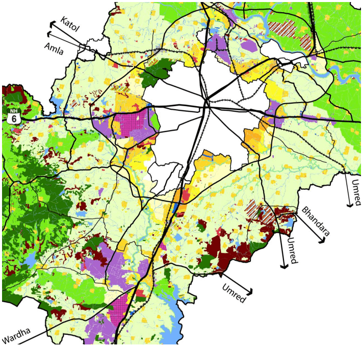
Spatially the R1 zone is mainly located within the outer ring road, along the city boundary in areas that are relatively urbanized and are currently witnessing real estate development activity such as parts of Besa-Beltarodi, Kapsi-Khurd, Wadi and so on.
13.3.1.2 Residential R2
The residential R2 zone is intended to be characterized with relatively higher intensity development, but lower than R1. It will also allow a wide range of non-residential compatible uses resulting in a mixed-use character, including hotels and service industries with certain conditions/limitations. The gross average
13-2
density in this zone is considered to be around 35- 25 du/ha or approximately 150- 110 pph. R2 Zone is allocated to areas close to R1 Zone.
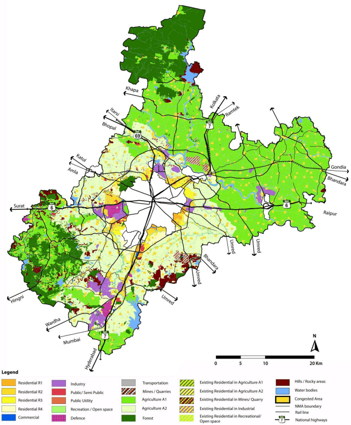
Figure 13-1: The Proposed Land Use Plan
13-3
Figure 13-2: Proposed Land Use Plan - Urban Uses

13.3.1.3 Residential R3
The Residential R3 zone is intended to be developed with similar intensity as R2, but with fewer non-residential uses with a limitation on maximum permissible built-up area for certain commercial uses within mixed-use plots. Service industries are not permitted in this zone. The gross average density in this zone is considered to be around 25- 15 du/ha or approximately 110- 65 pph.
13-4
Within the outer ring road, the R3 zone is located in areas adjacent to R2 zone, in parts of Besa-Beltarodi etc., parts of Hingana near Hingana MIDC, parts along the north east of the city boundary along NH-7 (Kamptee road). Outside the outer ring road, land along the either side of the south corridor near Jamtha stadium and area north of Butibori industrial area is under R3 zone.
13.3.1.4 Residential R4
Areas which are currently rural in character, and in the future intended to support only low to very low density development, but which are in close proximity to other planned urban uses are zoned under R4. Thus intense commercial uses housed in mixed-use buildings along with residential use is not permitted. Other non-residential uses mainly comprise retail shopping, repair etc., which are essential for servicing the residential uses. Multi-storey apartments and shop line are not allowed in this zone. On the other hand, large format commercial developments (built-up area above 20,000 m2) that are not otherwise permitted in R2 and R3 zones are permitted in independent plots within the R4 zone. Agro-based cottage/ small scale industries registered with the DIC are also permitted in independent plots.
The gross average density is considered to be about 15- 10 du/ha or approximately 65- 45 pph. These areas are under least priority for being serviced with infrastructure and therefore development of a limited intensity is permitted in these location. Land parcels adjoining R2 and R3 zones but which lie on the rural side in areas such as: south-east and south-west of Nagpur city and some parts of north-west and northeast within the outer ring road, and along the south corridor are under R4 zone. Residential area south of Butibori industrial area is also zoned under R4 and so are residential areas within the rural centres.
13.3.1.5 Addressing the Future Need for Growth of Gaothans in Rural Areas
Out of all villages in the NMA, about 146 villages are included in urban sectors and rural centres (see Table 12-15). Based upon the assessment of demographic and socio-economic conditions, it is revealed that the remaining 574 villages have limited potential to grow or benefit from urban zoning. These are therefore intended to remain largely rural in character and continue supporting agriculture and allied uses. On the other hand the plan recognises the need for allowing future growth beyond the boundaries of the gaothans of these rural villages, mainly for residential purposes. Therefore areas upto 200 - 250m from the boundary of gaothans are zoned as Congested Areas. This zone is however not allocated in the 77 villages which are not inhabited (Rithi) as per the Census 2011.
| S. No. | Residential Zone | Area (ha) | % land under residential zone | Average gross density Ppl/ ha* |
|---|---|---|---|---|
| 1 | Residential R1 | 2,116 | 5.87% | 220- 150 |
| 2 | Residential R2 | 5,393 | 60.71% | 150- 110 |
| 3 | Residential R3 | 4,646 | 12.88% | 110- 65 |
| 4 | Residential R4 | 7,408 | 20.54% | 65- 45 |
| 5 | Congested Area (Gaothans & gaothan expansion) | 165,00 | 45.0% | |
| Subtotal | 36,064 | 100% | ||
| 6 | Existing residential outside Urban Sectors** | 2,117 | ||
| Total | 38,180 |
*Gross density includes land under roads, open spaces and amenities/ utilities; ** Not target development areas
13-5
13.3.1.6 Non-conforming Residential Uses
Existing residential developments which are located in areas outside of the R1 to R4 zones are referred as non-conforming residential. For statistical purposes such non-conforming residential uses are also included in the residential zone. It is seen in the Table 13-2, that the area under R1 to R4 is 36,064 ha or 360.64 km2. Out of the total residential land 38,180 ha, balance land of 2,117 ha is under non-conforming residential use.
As long as such uses have valid development and building permissions, they will be allowed to continue in their existing density level (refer to section 5 of the Development Control Regulations). In the Development Plan, these are shown as ‘Residential in A1’, ‘Residential in A2’ and ‘Residential in Industrial’.