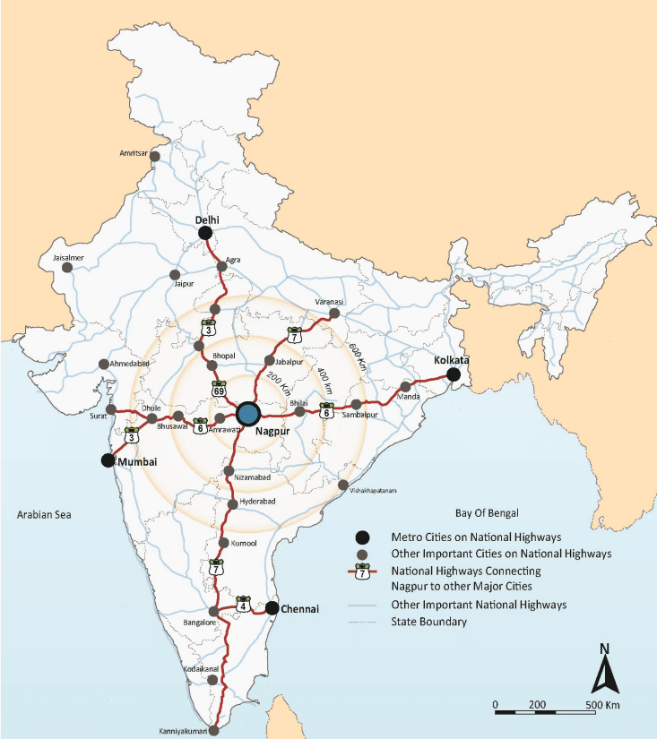
The NMA is located between the North Latitudes 20° 45’26”N and 21° 39’37”N and East Longitudes 78°41’16”E and 79°34’38”E, in eastern Maharashtra (see ).
Nagpur is one of the largest cities in central India and the third largest city in Maharashtra after Mumbai and Pune. It is also the winter capital of the state of Maharashtra. With a district population of over 4.6 million (as per Census 2011), it is the ninth largest urban agglomeration in India. Nagpur has historically been a major commercial and political centre of Vidarbha Region and continues to be so even today. Its location as the geographical centre of the country is physically established by the Zero Mile Marker. This geographic significance of the city endows it with huge logistics related potential.
2-3
Figure 2-2 : Regional setting
2-4
Chapter 2Introduction to the Nagpur Metropolitan Area
2.1 Project Area
2.1.1 Boundary and Extents
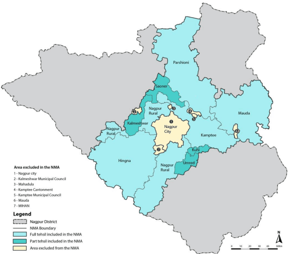
The Nagpur Metropolitan Area was notified on 2 3 r d July 1999. As per State government notification 726 villages were included in the NMA notified area1 under 9 tehsils (5 full tehsils – Nagpur Rural, Hingna, Kamptee, Parshioni, Mauda and 4 part tehsils – Saoner, Umred, Kalmeshwar and Kuhi), comprising of 726 villages of the Nagpur District. The total area as per the State Government notification is 3,577.70 km.
The NMA covers about 36 percent of the Nagpur District (9,892 km2) and is adjoined by Amravati and Wardha districts on the west, Bhandara District on the east and Chhinwada and Balaghat districts of Madhya Pradesh on its north-west. Figure- 2-1 illustrates the boundary and extents of the NMA.
Figure- 2-1 : Boundary and extents of the NMA
1 Government notification TPS 1699/1191/CR/80-99/UD-13, dated July 23, 1999
2-1
The areas managed by other planning authorities are excluded from the NMA area and are listed below:
Nagpur City area under Nagpur Municipal Corporation (NMC)
Multi-modal International Cargo Hub and Airport (MIHAN), for which Maharashtra Airport Development Company (MADC) is the planning authority
Industrial areas for which Maharashtra Industrial Development Corporation (MIDC) is the planning authority
Kamptee Cantonment area
Kamptee Town, for which Kamptee Municipal Council is the planning authority
Kalmeshwar Town, for which Kalmeshwar Municipal Council is the planning authority
2.1.2 Changes to the Extents and Area Notified as the NMA
Pursuant to the declaration of the NMA in 1999 the State Government issued another notification announcing changes to the boundary of the NMA notified area2. This was due to expansion of the notified area of NMC to include four villages Hudkeshwar Bhudruk and Narsala of the Nagpur Rural Tehsil; and upgrading villages Mauda of Mauda Tehsil and Mahadula of Kamptee Tehsil as Mauda Nagar Panchayat and Mahadula Nagar Panchayat respectively.
Furthermore, based on updated revenue information and latest village maps it was found that Kanhan and Pipri are not two separate villages but one single village with name Kanhan-Pipri (Parshioni Tehsil). Similarly, Warambha and Mahulvapi are not two separate villages but one single village with name Warambha (Kamptee Tehsil). On the other hand, Matkazari village of Umred Tehsil was divided into two separate villages of Matkazari and Kachimet.
The number of villages included the NMA have thus reduced from to 726 from 721. Hereafter all references to the total number of villages will be made to reflect this change. A list of these villages is given in Annexure 2.
The combined area of the 721 villages in the NMA amounts to 3,567.37 km2. This means that there is a difference of about 10 km2in the area given in the government notification and area as per the base map. Hereafter all references to the area will be made to reflect the actual measured area of the base map mentioned above. Description of the method and processes employed for carrying out the base mapping exercise is given in Chapter 6, 6.2 of this report. Table 2-1 gives the number of villages in tehsils of the NMA.
Table 2-1Revised number of villages in tehsils included in the NMA
Number of
Area of Tehsil
% area of Tehsil
S. No.
Tehsil
Villages
(km<sup>2</sup>)
in NMA
1
Parshioni
127
762.25
21%
2
Hingna
164
641.07
18%
3
Nagpur (Rural)
162
393.52
11%
4
Mauda
123
815.19
23%
2 Government notification TPS 2413/405/CR-213/2013/UD-9, dated October 14, 2013
2-2
5
Kamptee
77
617.24
17%
6
Saoner (Part)
27
125.1
4%
7
Kalmeshwar (Part)
21
103.1
3%
8
Umred (Part)
13
75.1
2%
9
Kuhi (Part)
7
34.8
1%
Total
721
3567.37
100%
2.3History of Evolution of the Metropolis
2.3.1 Overview
The overall Nagpur region is rich in illustrations of dynamic history and economic development. It is the aim here to take the physical and historical records to illustrate the interrelationships between economic development, social changes and the physical environment in the evolution of the overall metropolis.
The NMA includes peri-urban areas of Nagpur city, industrial suburbs of Hingna and Butibori, and the surrounding rural villages. The City of Nagpur, although a separate jurisdiction in terms of planning and development activities, is the main urban centre and the economic and cultural magnet for all the communities of the NMA. In order to obtain a holistic view of the evolution of the metropolitan area it is vital to gain insight into the sequence of development of Nagpur spanning across the past three centuries. This chapter provides a brief chronicle of the history of development of Nagpur City and the urban growth of the suburban communities which are now the primary growth areas of the NMA.