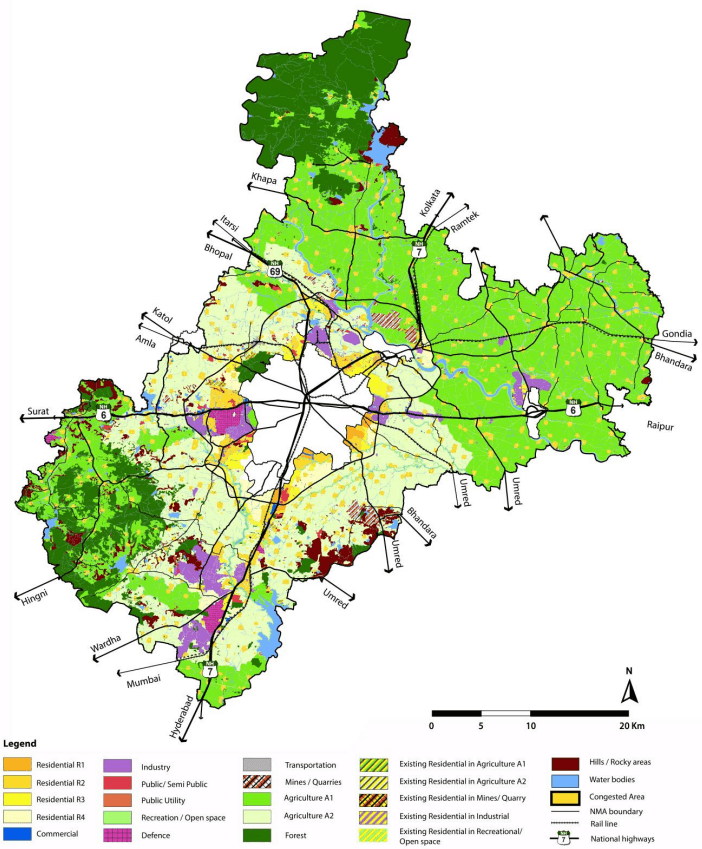
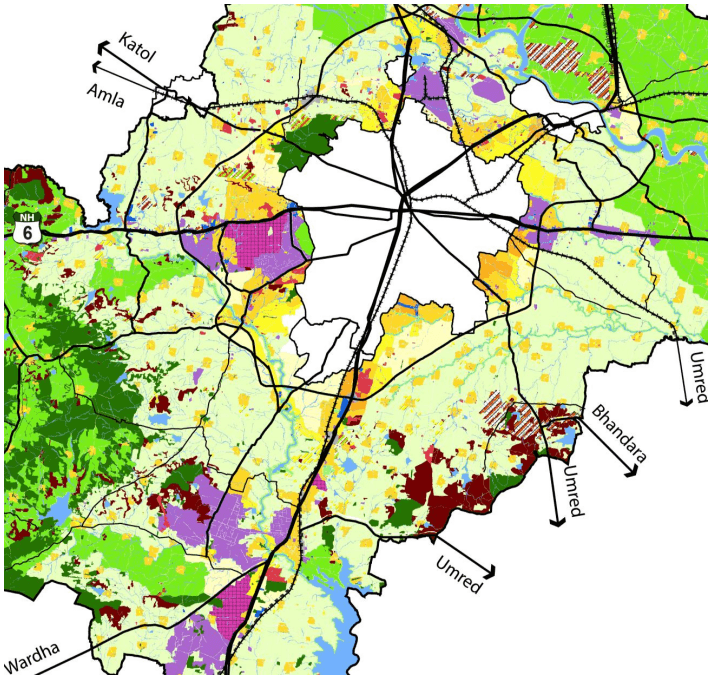
The structure plan and broad development policies discussed in chapter 11 form the base for the preparation of the proposed land use (PLU) plan. The PLU is shown in the Figure 13-1 and the areas under various land uses are given in the Table 13-1.
Table 13-1Areas under proposed land use zones
S. No.
Land use zone
Area (Sq km)
Percent of Urban land
Percent of Total area
1
Residential
381.81
50.53%
10.70%
2
Commercial
9.03
1.19%
0.24%
3
Industrial
101.20
13.39%
2.84%
4
Public-Semipublic
61
8.08%
1.71%
5
Public Utility
7.91
1.05%
0.22%
6
Recreation/Open space
67.98
9.00%
1.91%
7
Defense
23.64
3.13%
0.66%
8
Transportation
142.16
18.81%
3.99%
Subtotal Urban
755.64
100.00%
21.17%
9
Hills
108.62
3.04%
10
Mines/Quarries
28.49
0.80%
11
Agriculture
2007
56.26%
12
Forest
508.46
14.25%
13
Waterbodies
228.52
6.41%
Total Area
3,567.37
100.00%
It can be seen in the above table that about 755 km2 of land, which is about 21 percent of the total area of the NMA, is zoned under future urban uses.
13-1
13.3.1Residential
About 381 km2land is zoned under residential use which covers about 50.53 percent of the total land zoned for urban uses within the NMA, and about 10.7 percent area of the NMA. In response to the idea of managing the rural-urban transect, this is further categorized into four zones – R1, R2, R3, and R4. The four residential zones support varying intensity and character of development depending upon what a particular area is most suitable for.
13.3.1.1 Residential R1
The Residential R1 zone is allocated to areas close to existing employment centres such as Nagpur City, MIHAN, Hingana, etc., which are already witnessing development activity. In terms of real estate demand these are the defacto areas to house future growth and thus allow for most intense development and higher mix of uses among all residential zones in the NMA including hotels and service industries with certain conditions/limitations. The gross average density in this zone is considered to be 55-35 dwellings per hectare (du/ha) or approximately 220 - 150 persons per hectare (pph). Amenities and facilities supporting residential uses are considered with these and generally includes commercial, open space etc.
Spatially the R1 zone is mainly located within the outer ring road, along the city boundary in areas that are relatively urbanized and are currently witnessing real estate development activity such as parts of Besa-Beltarodi, Kapsi-Khurd, Wadi and so on.
13.3.1.2 Residential R2
The residential R2 zone is intended to be characterized with relatively higher intensity development, but lower than R1. It will also allow a wide range of non-residential compatible uses resulting in a mixed-use character, including hotels and service industries with certain conditions/limitations. The gross average
13-2
density in this zone is considered to be around 35- 25 du/ha or approximately 150- 110 pph. R2 Zone is allocated to areas close to R1 Zone.
Figure 13-1: The Proposed Land Use Plan
13-3
Figure 13-2: Proposed Land Use Plan - Urban Uses
13.3.1.3 Residential R3
The Residential R3 zone is intended to be developed with similar intensity as R2, but with fewer non-residential uses with a limitation on maximum permissible built-up area for certain commercial uses within mixed-use plots. Service industries are not permitted in this zone. The gross average density in this zone is considered to be around 25- 15 du/ha or approximately 110- 65 pph.
13-4
Within the outer ring road, the R3 zone is located in areas adjacent to R2 zone, in parts of Besa-Beltarodi etc., parts of Hingana near Hingana MIDC, parts along the north east of the city boundary along NH-7 (Kamptee road). Outside the outer ring road, land along the either side of the south corridor near Jamtha stadium and area north of Butibori industrial area is under R3 zone.
13.3.1.4 Residential R4
Areas which are currently rural in character, and in the future intended to support only low to very low density development, but which are in close proximity to other planned urban uses are zoned under R4. Thus intense commercial uses housed in mixed-use buildings along with residential use is not permitted. Other non-residential uses mainly comprise retail shopping, repair etc., which are essential for servicing the residential uses. Multi-storey apartments and shop line are not allowed in this zone. On the other hand, large format commercial developments (built-up area above 20,000 m2) that are not otherwise permitted in R2 and R3 zones are permitted in independent plots within the R4 zone. Agro-based cottage/ small scale industries registered with the DIC are also permitted in independent plots.
The gross average density is considered to be about 15- 10 du/ha or approximately 65- 45 pph. These areas are under least priority for being serviced with infrastructure and therefore development of a limited intensity is permitted in these location. Land parcels adjoining R2 and R3 zones but which lie on the rural side in areas such as: south-east and south-west of Nagpur city and some parts of north-west and northeast within the outer ring road, and along the south corridor are under R4 zone. Residential area south of Butibori industrial area is also zoned under R4 and so are residential areas within the rural centres.
13.3.1.5 Addressing the Future Need for Growth of Gaothans in Rural Areas
Out of all villages in the NMA, about 146 villages are included in urban sectors and rural centres (see Table 12-15). Based upon the assessment of demographic and socio-economic conditions, it is revealed that the remaining 574 villages have limited potential to grow or benefit from urban zoning. These are therefore intended to remain largely rural in character and continue supporting agriculture and allied uses. On the other hand the plan recognises the need for allowing future growth beyond the boundaries of the gaothans of these rural villages, mainly for residential purposes. Therefore areas upto 200 - 250m from the boundary of gaothans are zoned as Congested Areas. This zone is however not allocated in the 77 villages which are not inhabited (Rithi) as per the Census 2011.
Table 13-2Target densities and area allocated under each residential zone
S. No.
Residential Zone
Area (ha)
% land under residential zone
Average gross density Ppl/ ha*
1
Residential R1
2,116
5.87%
220- 150
2
Residential R2
5,393
60.71%
150- 110
3
Residential R3
4,646
12.88%
110- 65
4
Residential R4
7,408
20.54%
65- 45
5
Congested Area (Gaothans & gaothan expansion)
165,00
45.0%
Subtotal
36,064
100%
6
Existing residential outside Urban Sectors**
2,117
Total
38,180
*Gross density includes land under roads, open spaces and amenities/ utilities; ** Not target development areas
13-5
13.3.1.6 Non-conforming Residential Uses
Existing residential developments which are located in areas outside of the R1 to R4 zones are referred as non-conforming residential. For statistical purposes such non-conforming residential uses are also included in the residential zone. It is seen in the Table 13-2, that the area under R1 to R4 is 36,064 ha or 360.64 km2. Out of the total residential land 38,180 ha, balance land of 2,117 ha is under non-conforming residential use.
As long as such uses have valid development and building permissions, they will be allowed to continue in their existing density level (refer to section 5 of the Development Control Regulations). In the Development Plan, these are shown as ‘Residential in A1’, ‘Residential in A2’ and ‘Residential in Industrial’.
13.3Proposed Land Use Zones
With a view to guide future development in the NMA, 13 land use zones are delineated. The land use zones form the basis for regulating activities and uses.
Mix of uses is a fundamental aspect of every urban land use zone (except in restricted zones such as Defence, Mines/ Quarries and Forests and so on). As described in Chapter 11, the benefits of mixed uses are multi-fold – it reduces dependence on automobiles, encourages walkability, lowers crime incidents and fosters greater opportunities for collaboration within communities.
Section 22 of the Development Control Regulations gives a detailed description of the uses permitted in each land use zone. Aspects that define each of these land use zones are given below.
Provisions of the sanctioned Regional Plan for Nagpur District 1991- 2011 has been considered while allocating land for urban uses. Chapter 6 of this Report presents a detailed assessment of existing land uses within the growth sectors demarcated in the Regional Plan. Based on the actual development on ground (market response) it was concluded that these areas have not witnessed growth as envisioned. Thus, there are certain deviations from the Regional Plan. These deviations have been recorded and presented in Annexure 19.
13.3.3Industrial
Industries as employment hubs are zoned closer to the city and along major road corridors. Most of these are in existing established industrial areas such as Hingna, Butibori, Koradi-Khaparkheda and Mauda. Kapsi-Khurd on the east and Hingna on the west also have proposed industrial uses. About 13.39 percent urban land (and 2.84 percent of the overall NMA area) is under the industrial zone, which amounts to an area of about 101.20 km2.
Commercial uses such as offices, banks are allowed in the industrial zone. Limited residential uses can be developed in industrial plots, however high density typologies such as multi-storey apartments are not desired in proximity of industries and therefore restricted. On the other hand, housing for industrial workers is permitted with certain minimum requirements for access and safety.
13-6
13.3.4Public Semi-public
The public semi-public zone covers about 8.08 percent land under urban uses which amounts to about 61 km2. This includes existing government institutions, public and private social amenities and proposed reservations for schools, colleges, hospitals, etc., as public purpose facilities.
Land reservations for additional social amenities are proposed as per the 1976 State government norms. Reservations are provided for the resulting gap in provisions with respect to population for residential clusters based on the assumed residential densities. The provision of social amenities and public facilities is described in detail under 13.5, social amenities and public facilities.
13.3.2Commercial
The general approach towards land use zoning is to encourage mix of compatible uses. Therefore regular retail and commercial development is permissible in residential zones. It is intended for land under commercial zone to allow exclusive development of large retail and specialized commercial uses like offices, hotels etc.
About 8.7 km2land is under commercial zone which represents about 1.15 percent of the land intended to be under urban uses. It should be noted that once development commences the actual area under commercial use will be much more as some commercial uses, with certain limitations, are allowed within residential zones. It is also proposed that residential built-up area in any plot within the commercial zone be restricted so that the envisioned character of commercial zone is maintained.
Pockets of land around key corridors in which commercial real estate activity is being witnessed such as areas in Besa in south-east, Wanadongri along Hingna road on the west, Umred road on south-east and along NH-7 near Bhilgaon, Khairy Yerkhada in the north. In terms of new commercial areas (where this activity is not predominant at present but will be newly introduced), portion of land near the VCA stadium at Jamtha and near Dongargaon station along the south corridor is zoned for this use.
Chapter 13Planning Proposals
13.1 Introduction
This chapter details out the proposed planning interventions strategized to guide future development within the framework of envisioned goals and objectives for the NMA. These include:
Proposed land uses;
Social amenities and public facilities;
Transportation;
Water supply infrastructure;
Sewerage and drainage infrastructure;
Power supply infrastructure and
Solid waste disposal facility.
13.3.5Open Space and Recreation
The approach taken to zoning land under the open space and recreation zone prioritizes on using the development plan to protect and preserve ecologically sensitive areas along rivers. A buffer of 100 m along the entire stretch of rivers Kanhan and Pench within the NMA, 50 m along rivers Vena, Nag, Sur, Sand and Bor has also been included under this zone.
Reservations for public open spaces as per the 1979 state government norms are included under this zone. Land allocations under reservations are described in further detail under 13.5, social amenities and public utilities. As far as possible land under this zone utilizes government owned parcels, but it is not uncommon to find private land zoned for such uses to meet the needs of future residential population.
About 68 km2, which is about 9 percent land under urban uses is under open space and recreation zone. All types of open spaces such as parks, gardens, playgrounds, landscaped/theme based gardens etc., are permitted as principle uses. Certain other uses which involve construction of buildings as accessory uses with limitations on total built-up area. Buildings within the river buffers will be designed and constructed as ‘low impact developments’.
13.3.6Agriculture
The agriculture zone comprises of the largest share – about 56 percent of the total land (2007 km2) within the NMA. A significant portion in this zone comprises of land with fertile soils under the irrigation command areas and is treated as ‘prime agriculture land’ which should be preserved. This zone is therefore further divided into two sub-zones – A1 for farmlands under the irrigation command areas and A2 for farmlands which are not irrigated at present. Of the total land under Agriculture, about 65 percent and 35 percent agricultural lands are zoned under A1 and A2 respectively. Limited non-agriculture uses are allowed in both zones; however the restrictions for development in A1 zone are relatively more stringent with regard to intensity of development and uses permitted.
13.3.7Public Utility
Land under the public utility zone is intended for locating essential utilities and services such as sewage treatment plants, elevated storage reservoirs, water works, electric sub-stations, cremation and burial grounds, solid water management and disposal site, solid waste transfer stations and so on. Each urban sector contains land allocations towards public utilities based on the established norms and standards. The existing public utilities are included in this zone along with proposed land reservations. Specific proposals
13-7
are described in detail further in this chapter. In all about 1.05 percent of the urban uses or 7.91 km2 area is allocated to this zone.
13.3.8 Transportation
The Transportation zone includes land under public road and rail right of ways, proposed bus depots, truck terminals and railway stations and so on. Specific transportation proposals are described in further detail in 13.5. About 18.81 percent land under urban uses is zoned under transportation.
13.3.9 Forest
Lands shown under the forest zone are under the ownership of the forest department. No development shall be permitted in this zone. A significant proportion of the NMA – about 14.25 percent of the total NMA area amounting to over 508.46 km2 is covered by the forest zone.
13.3.10 Defence
Land owned by the defence department covers over 3.13 percent of the total area under urban uses. Development within this zone shall be managed and regulated by norms set out by Ministry of Defence.