The overall land development strategy focuses on growth largely within the Outer Ring Road and along the southern corridor. The road network intersection densities have been developed based on the urban-rural transect transition – denser in urban areas and sparse in rural/ forested zones.
The Plan emphasizes on mobility, access and safety for non-motorised transport. Road right of ways allow sufficient space for sidewalks and bicycle lanes shaded by trees and provided with street lights. The road network follows a ring radial pattern with major radials emanating from the city. In order to facilitate local traffic movement across the major radials, new connections are proposed between the radials. Capacity expansion of existing major radials is also proposed with a view to ease heavy traffic movement.
The road network plan is aligned with the PWD Master Plan. New roads are proposed in areas with allocated for urban uses within Urban Sectors road. Links are proposed to connect gaps in to create an outer radial road and complete a loop of the regional road network.
| S. No. | Land use zone | Area (Sq km) | Percent of Urban land | Percent of Total area |
|---|---|---|---|---|
| 1 | Residential | 381.81 | 50.53% | 10.70% |
| 2 | Commercial | 9.03 | 1.19% | 0.24% |
| 3 | Industrial | 101.20 | 13.39% | 2.84% |
| 4 | Public-Semipublic | 61 | 8.08% | 1.71% |
| 5 | Public Utility | 7.91 | 1.05% | 0.22% |
| 6 | Recreation/Open space | 67.98 | 9.00% | 1.91% |
| 7 | Defense | 23.64 | 3.13% | 0.66% |
| 8 | Transportation | 142.16 | 18.81% | 3.99% |
| Subtotal Urban | 755.64 | 100.00% | 21.17% | |
| 9 | Hills | 108.62 | 3.04% | |
| 10 | Mines/Quarries | 28.49 | 0.80% | |
| 11 | Agriculture | 2007 | 56.26% | |
| 12 | Forest | 508.46 | 14.25% | |
| 13 | Waterbodies | 228.52 | 6.41% | |
| Total Area | 3,567.37 | 100.00% |
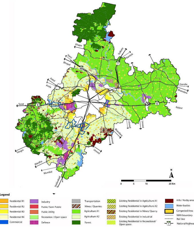

Figure 6: Proposed Land Use Plan