Water supply within the NMA and the larger region is sourced from surface and ground water sources. Based on the type and source of supply, the region can be categorised into three main categories:
urban areas including municipal corporation and municipal councils/ nagar parishads outside the NMA;
rural village settlements and census towns;
agricultural land
Water supply for urban areas is sourced from surface water sources like lakes, rivers and reservoirs to cater to the domestic, commercial, institutional, and industrial demands of city as well as ground water.
In the rural areas, water is being supplied through the rural water supply schemes implemented by agencies like the Zilla Parishad (ZP), the Maharashtra Jeevan Pradhikaran (MJP) or the Groundwater Survey and Development Agency (GSDA) that tap ground water by developing tube wells, hand pumps and bore wells. Surface water for domestic consumption is sourced from local water bodies or canals whereas irrigation of the agricultural land is being done through a combination of ground and surface water sources such as canals, tube wells and bore wells.
Water supply to the urban areas is dependent upon both surface and ground depending upon its availability. Details of major water sources available for the development of NMA are addressed below.
Chapter 8Utilities and Services
This chapter discusses the existing utilities infrastructure provisions such as water supply, power, sewerage, drainage, telecom and gas in the NMA. The collated data is based on the available information from published reports, studies and interactions with various government agencies supported by observations during site visits. As discussed earlier in this report, the major urban areas such as the NMC, Kamptee and Kalmeshwar Municipal Councils and MIDC areas are outside the NMA extents. The areas within NMA are either developing rural areas or growing urban areas on the fringes of NMC and Municipal councils, which currently are not being serviced with utilities.
Much of the available information pertaining to utilities infrastructure is limited to the NMC and municipal council limits. The Nagpur District Regional Plan 1991-2011 broadly addresses the issue of infrastructure development in the new urban areas and rural areas within the metropolitan area.
This chapter covers a summary of key findings for various utility components in the NMC and municipal councils, supported by available information pertaining to growing urban and rural areas. Although the corporation and council areas are outside NMA boundaries, study of infrastructure provisions for these urban areas helps provide some background to that in the NMA.
8.1.1Ground Water Sources
Ground water is the main source of NMA area and is being developed by two types of abstraction structures; bore wells and dug wells. Dug wells are the main ground water abstraction structures with yield
8-1
varying from 20 to 380 m3/day. Minor irrigation census data (2000-2001) indicates that area irrigated by ground water is 914.68 km2 whereas surface water accounts for 241.74 km2 of area. It shows that the ground water is main source of irrigation in the NMA accounting about 73 percent of net irrigated area. The district has a total number of 59,407 irrigation dug wells, creating an irrigation potential of 1,413.71 km2 out of which 1,236.25 km2 of irrigation potential is utilised (Source - Nagpur Regional Plan 1991-2011).
The Government of Maharasthra (GoM) has developed a large number of bore wells fitted with hand pumps and electric motors for rural drinking water supply purposes in the district. Upto the year 2006-2007, the GSDA and the GoM have developed about 9,953 bore wells for rural water supply, out of which 9,483 are fitted with hand pumps and 470 with electric pumps (Source – MJP).
The NMA lies in the Godavari river basin contributing to the catchments of Waingangā River through the Kanhan River passing from the centre of the district. The Central Ground Water Board (CGWB) has conducted several studies in the district to understand the characteristics of ground water reserves in the region and assess the development potential of Nagpur. Salient features of ground water availability within the tehsils of the NMA are summarised in Table 8-1.
Table 8-1Salient features of ground water availability
Tehsil
EW
Wells OW
PZ
Depth (mbgl)
SWL* (mbgl)
Discharge (lps)
Draw-Down (m)
Zones (mbgl)
Parshioni
17
4
2
27.5-199.64
4.05-19.6
0.08-7.76
-
6.0-163.05
Hingana
2
3
-
85.4-234.8
14.68-27.65
0.5-21.33
-
-
Nagpur (Rural)
2
-
1
76.59-159.45
24.15
1.37-2.64
-
7.0-75.0
Mauda
2
1
-
174.5-187.25
1.0
1.37-4.43
25.06-42.58
34.75-147.65
Kamptee
6
3
-
29.93-202.45
4.53-16.45
1.37-8.85
-
11.0-140.4
Saoner
8
17
1
43.0-307
2.30-29.05
0.38-14.40
8.05-31.06
5.25-140.2
Kalmeshwar
9
4
79.3-278
4.55-28.5
0.38-17.92
5.6-11.95
28.0-107
Umred
2
2
67.5-200
3.64-5.07
0.01-2.16
24.0-122
Kuhi
4
3
36.5-200
-
-
-
5.0-99.75
Total
52
35
6
27.5-307
1.0-29.05
0.01-21.33
5.6-42.58
5.0-163.05
Source: Ground Water Information Nagpur District Maharashtra, Central Region Nagpur 2009
EW -Exploratory wells, OW - Observation wells, PZ – Piezometers, mbgl – metre below ground level;* SWL: Shallow Water Level
The depths of wells vary from 6.5 to 307 metres below ground level (mbgl) across Nagpur district and ranges from 27.5-307 mbgl within the tehsils of the NMA. Quantity of discharge varies between 0.01 and 38.5 litres per second (lps) across Nagpur district and 0.01 and 21.33 lps within the NMA. The deepest water level has been recorded at Pipla village in Saoner Tehsil that is 29.05 mbgl and the deeper aquifer zones have been encountered in many wells beyond 50 m depth, the deepest being at 287.73-296.57 m at Sillewada exploratory well in Saoner Tehsil.
Dynamic ground water potential in Nagpur District:
o Net annual ground water availability: 1041.89 million cubic metres (mcm)
o Annual ground water draft (irrigation - domestic): 452.95 mcm
8-2
8-3
o Allocation for domestic and industrial requirement up to next 25 years: 102.28 mcm
o Stage of ground water development: 43.47%
Source: Ground Water Information Nagpur District Maharashtra, Central Region Nagpur 2009
Ground water control and regulation assessment in Nagpur District:
o Over-exploited tehsils None
o Critical tehsils None
o Semi-critical tehsils Katol and Narkhed
o Notified tehsil None
Source: Ground Water Information Nagpur District Maharashtra, Central Region Nagpur 2009
Ground Water Quality
The available data also reveals that the water quality in many of the villages in NMA is affected by the presence in excessive quantity of nitrate (NO3), chloride (Cl), fluoride (F), iron (Fe) and total dissolved solids (TDS). Use of the water in a particular area can be decided after getting the water quality tested. Ground water quality in parts of Nagpur city is adversely affected by nitrate contamination, whereas in Kalmeshwar and Hingna MIDC areas the contamination of ground water in the phreatic zone has been observed due to discharge of industrial effluents (Ground Water Information Nagpur District Maharashtra, Central Region Nagpur 2009).
Prevailing Ground Water level in NMA
The CGWB periodically monitors the National Hydrograph Network Stations (NHNS) across the Nagpur district four times a year that is January, May (pre-monsoon), August and November (post-monsoon) to assess the dynamics of water levels in the district. Water level depths in the area in different seasons of the year have been described under the following subheads:
o Pre-monsoon (May-2007)
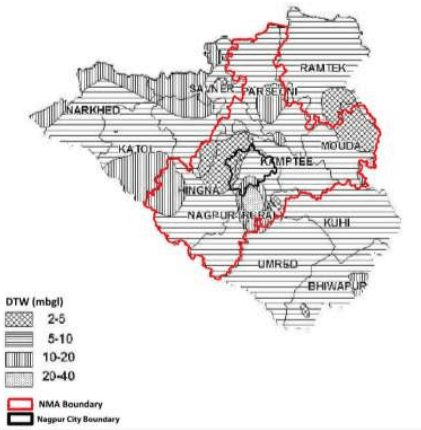
The depth to water levels in the district in May 2007 ranged between 2.00 mbgl (noted at VRCE, Nagpur) to 39.70 mbgl (noted at Panchgaon- PZ). Pre-monsoon water level depths across the district and within the NMA have been depicted in Figure 8-1. The studies show the shallow water levels within 10 mbgl in almost entire district and the shallowest water levels are observed near Nagpur city and area near Mauda. Water levels in the range of 10-20 mbgl are observed in the western and north western part of district in parts of Narkhed, Saoner and Katol Tehsil and isolated patches in Parshioni, Bhiwapur and Nagpur Rural Tehsil.
Figure 8-1 : Depth of ground water level (May 2007)
Source: Ground Water Information Nagpur District Maharashtra, Central Region Nagpur 2009
o Post-monsoon (Nov, 2007)
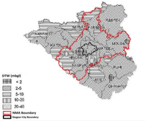
The depth to water levels in the district in November 2007 has been observed between 0.65 mbgl (noted at Waddhamna) and 28.65 mbgl (noted at Panchgaon-PZ). The spatial variation in post-monsoon depth to water levels is shown in Figure 8-2. In the entire district the water levels are shallow within 10 mbgl. The water levels of 2 to 5 mbgl is the most dominant range occupying major parts of Ramtek, Mauda, Kuhi and Bhiwapur Tehsils. Water levels of less than 2 mbgl are observed in isolated patches near Nagpur City and in parts of Mauda Tehsil. The northern peripheral part of the district from Narkhed to Ramtek Tehsil and two big patches in the middle portion covering parts of Katol, Hingana, Umred and Nagpur Rural Tehsils have deeper water level of more than 5 mbgl.
8-4
Figure 8-2 : Depth of water level (Nov 2007)
Source: Ground Water Information Nagpur District Maharashtra, Central Region Nagpur 2009
o Seasonal Water Level Fluctuation – (May to Nov 2007)
Rise in water levels has been observed in the entire Nagpur district and in major part of the district it has raised from 0.25 m (recorded at VRCE, Nagpur) to 11.05 m (recorded at Panchgaon - PZ). The rise in water level is mostly within 7.5 m. Major parts of the district covering entire Ramtek, Parshioni, Mauda, Umred, Hingna and Nagpur (Rural) show higher fluctuation of 4 m to 7.5 m. The western part comprising of Katol, Narkhed, Saoner and Kalmeshwar tehsil and Bhiwapur tehsil in the east have lower fluctuation of less than 4 m.
Ground Water Reserves in the NMA
The CGWB and GSDA have jointly estimated the ground water reserves of Nagpur district. Ground water reserves by tehsils and its use for different purposes have been presented in Table 8-2. The total annual ground water recharge in the district is about 1,102.27 mcm with the natural discharge of 60.38 mcm making 1,041.89 mcm water available for the annual extraction and for different purposes.
8-5
Table 8-2Ground water resources in the NMA by tehsil
Tehsil
Area Type
Net annual ground water availability (ha.m/yr.)
Annual Ground Water Draft (ha.m/yr.)*
Allocation for domestic and industrial requirement for next 25 years (ha.m/yr.)
Groundwater availability for future irrigation (ha.m/yr.)
Stage of Ground water development (%)
Category
Irrigation
Domestic and Industrial Uses
Total
Parshioni
Command
6822.35
638.09
218.53
856.62
437.06
5747.20
12.56
Safe
Non-command
1362.09
340.97
73.50
414.47
146.99
874.13
30.43
Total
8184.45
979.06
292.03
1271.09
584.05
6621.33
15.53
Hingna
Command
696.32
211.15
34.23
245.38
68.45
416.71
35.24
Safe
Non-command
7525.66
1857.59
401.93
2259.51
763.48
4904.59
30.02
Total
8221.98
2068.74
436.15
2504.89
831.93
5321.30
30.47
Nagpur (Rural)
Command
198.71
32.39
9.97
42.36
19.94
146.37
21.32
Safe
Non-command
6638.73
2427.29
369.17
2796.46
738.34
3473.09
42.12
Total
6837.44
2459.68
379.14
2838.83
758.28
3619.46
41.52
Mauda
Command
13711.98
1412.33
365.84
1778.17
731.67
11567.98
12.97
Safe
Non-command
373.80
88.68
43.93
132.61
87.86
197.26
35.48
Total
14085.78
1501.01
409.76
1910.78
819.53
11765.24
13.57
Kamptee
Command
5718.60
1605.01
339.00
1944.01
677.99
3435.60
33.99
Safe
Non-command
705.99
380.12
57.47
437.59
114.94
210.93
61.98
Total
6424.59
1985.13
396.47
2381.60
792.93
3646.53
37.07
Saoner
Command
3160.42
994.03
67.98
1062.01
92.16
2096.63
33.60
Safe
Non-command
3681.17
3467.50
275.84
3743.33
180.25
725.84
101.69
Total
6841.59
4461.52
343.82
4805.34
272.41
2822.47
70.24
Kalmeshwar
Command
334.78
349.73
14.64
364.37
5.48
2.05
108.84
Safe
8-6
Tehsil
Area Type
Net annual ground water availability (ha.m/yr.)
Annual Ground Water Draft (ha.m/yr.)*
Allocation for domestic and industrial requirement for next 25 years (ha.m/yr.)
Groundwater availability for future irrigation (ha.m/yr.)
Stage of Ground water development (%)
Category
Irrigation
Domestic and Industrial Uses
Total
Non-command
6839.21
5014.18
302.17
5316.34
572.95
1276.74
77.73
Total
7173.99
5363.91
316.81
5680.72
578.43
1278.79
79.18
Umred
Command
1252.81
163.79
107.69
271.47
208.58
880.45
21.67
Safe
Non-command
8876.41
1643.17
324.42
1967.59
648.84
6584.40
22.17
Total
10129.23
1806.96
432.10
2239.07
857.42
7464.85
22.10
Kuhi
Command
438.53
123.68
30.13
153.81
60.25
254.60
35.07
Safe
Non-command
7189.16
2189.78
472.05
2661.83
944.10
4055.28
37.03
Total
7627.69
2313.46
502.18
2815.64
1004.35
4309.88
36.91
Total
Command
32334.5
5530.2
1188.01
6718.2
2301.58
24547.59
22.19
Safe
Non-command
43192.22
17409.28
2320.48
19729.7
4197.75
22302.26
54.74
Total
75526.74
22939.47
3508.46
26447.9
6499.33
46849.85
43.47
Source: Ground Water Information Nagpur District Maharashtra, Central Region Nagpur 2009; *hectare metre/year