7.2.1 Regional Connectivity
7.2.1.1 Road Network
Three important national highways, NH-6 and NH-7, pass through the city and provide direct connectivity with a number of major cities of India. NH-69 is the third national highway that starts at Nagpur and connects the cities along it and further to national capital New Delhi through NH-3 and NH-2. The alignment of each of these highways and other roads is shown in Figure 7-1.
The NH-6 is an important connection between eastern and western parts of India. With a length of about 1,950 km, it starts at Kolkata in West Bengal and ends at Hazira in Gujarat passing through the states of Orissa, Chhattisgarh and Maharashtra.
7-1
Figure 7-1 : NMA Road Network
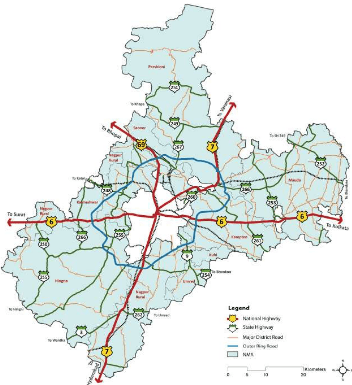
NH-7 is the longest highway in India with a length of about 2,370 km connecting Varanasi in Uttar Pradesh to Kanyakumari in Tamil Nadu. Passing through Madhya Pradesh, Maharashtra and Andhra Pradesh states, this acts as the major connection between Northern and Southern India. NH-69 connects Nagpur to Bhopal in Madhya Pradesh. Though the highway is only for a short distance, it provides good connectivity to the capital of Madhya Pradesh and also acts as the connection to NH-3 that leads to Gwalior, Agra, Delhi and North India through NH-2.
7-2
These national highways are being widened to 4/6 lanes under National Highway Development Programme (NHDP). NH-7 mainly has four lane configuration (except the part between Kamptee and Kanhan), while NH-6 is four laned only on western side of Nagpur at present. The part of NH-6 (between Pardi naka and Nagpur District boundary) and NH-69 has 2 lane configuration within the NMA.
7.2.1.2 Rail Network
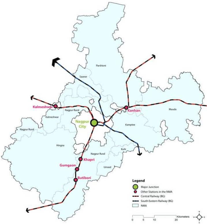
As is the case with roads, Nagpur is endowed with immense benefits on account of its strategic location at the intersection of nationally important broad gauge rail lines of the Central Railway and South Eastern Railway network (Mumbai-Kolkata and Delhi- Chennai). It is thus an important rail hub in India connected to major cities like Mumbai, Kolkata, Delhi, Chennai, Hyderabad, Bangalore, Pune, and Ahmedabad.
In addition to the broad gauge rail, narrow gauge rail connects Nagbhid and Chindwada (Madhya Pradesh) through Nagpur. About 50 trains ply on Nagpur – Delhi route, about 30 trains on Nagpur – Kolkata route and about 10 trains on the narrow gauge railway line every day. The total rail network length in the Nagpur Metropolitan Area is 126.44 km. The railway network in the NMA is shown in Figure 7-2. Besides the Nagpur City railway terminal, two important railway stations are located at Ajni and Itwari in the Nagpur City. Other important railway stations located in the NMA include Kanhan, Kamptee, Khapri, Gumgaon, Butibori and Kalmeshwar.
7.2.1.3 Air
The existing Nagpur airport is located near Sonegaon and it has been renamed as Dr. Ambedkar International Airport in year 2005. The air traffic control of Nagpur is the busiest in India because of its central location as more than 300 international flights fly over the city every day. The city is also connected with other cities of India through services operated by domestic carriers such as Air India, Jet Airways, Indigo, and GoAir connect Nagpur with major cities like Mumbai, Delhi, Ahmedabad, Pune, Bangalore, Hyderabad, Indore, and Kolkata. Around 37 destinations in India are within a time duration of less than an hour and half from Nagpur.
Nagpur is also emerging as an important player on the international aviation routes. It is connected to international destinations such as Bangkok, Singapore, Doha, Dubai, and Sharjah. Its unique location at the crossing of the air route between Europe and South- East Asia, as well as between South Africa and North-East Asia makes it a logical and ideal location for passenger and cargo hub. A multi-modal hub is being developed in Nagpur based on the hub-and-spoke system - the Multi-modal International Hub Airport (MIHAN).
7-3
Figure 7-2 : NMA Rail Network