Social infrastructure comprises of the facilities and mechanisms for provision of education, health care, community development, and social welfare to the people. Its availability, gamut and sophistication is a very important measure of any region’s overall development and quality of life.
This chapter provides an overview of the social infrastructure facilities, healthcare, education and recreation, available within the Nagpur Metropolitan Area (NMA). A detailed study was done to ascertain the availability of existing social amenities in the NMA. The Census 20011 and District Statistical Abstract 2010 are the two key datasets used to determine the number of available facilities. This would eventually help assess requirement for new facilities which need to be provided under the Development Plan proposals for the future population of the NMA. Additionally, these facilities would also serve the existing population if the existing amenities are found to be deficient in number, which would be determined by the established standards for provision of social amenities described in Chapter 12.
The different categories of social infrastructure which were studied are as follows:
1. Education
Primary School
Secondary School
Colleges & Higher education
2. Medical Facilities
Anganwadi
Primary health centres and Sub centres
Hospital
Recreation Facilities
1 At the time of publishing of this document, village wise detailed information for social infrastructure was not available for Census 2011. Therefore, Census 2001 data has been used for statistics regarding existing provision of education and health infrastructure.
9-2
9.3Medical Facilities
With rapid growth in privately operated medical facilities and services, healthcare provision in the current age no longer remains as an exclusive government domain. The discussion under this part relies heavily on the data available from District Statistical Abstract 2010 as well as the data available from the 2001 Census.
9.3.1 Rural health care system in NMA
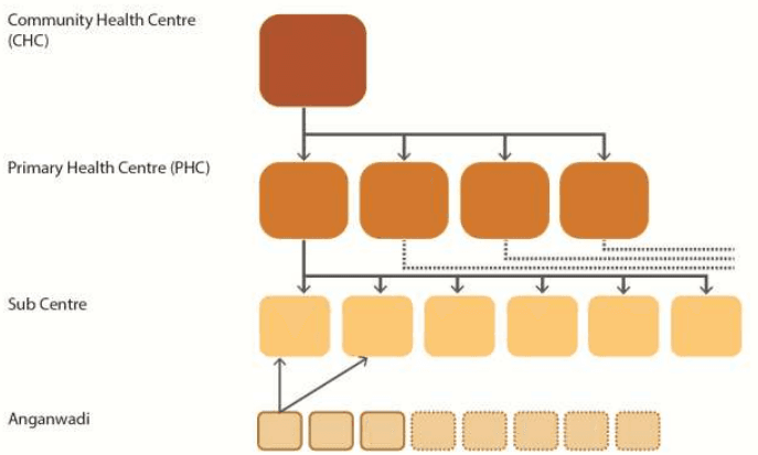
For rural areas, a tiered system of government medical facilities has been established by the State Government (See Figure 9-4: Tiered rural health care system
A Community Health Centre (CHC) which is 30 bedded hospital has about four to five Primary Health Centres (PHC) under it. Each PHC has 5-6 sub centres attached to it while Anganwadis form the widest base for healthcare in the villages. They are not attached to any sub centre but refer to the nearest sub centre. The Anganwadis play a very crucial role in this system as they are the first link for the rural populace, particularly children and women, to basic health care.
Additionally, on top of this tiered system are rural hospitals which serve population of about 2.5 lakh each.
Figure 9-4: Tiered rural health care system
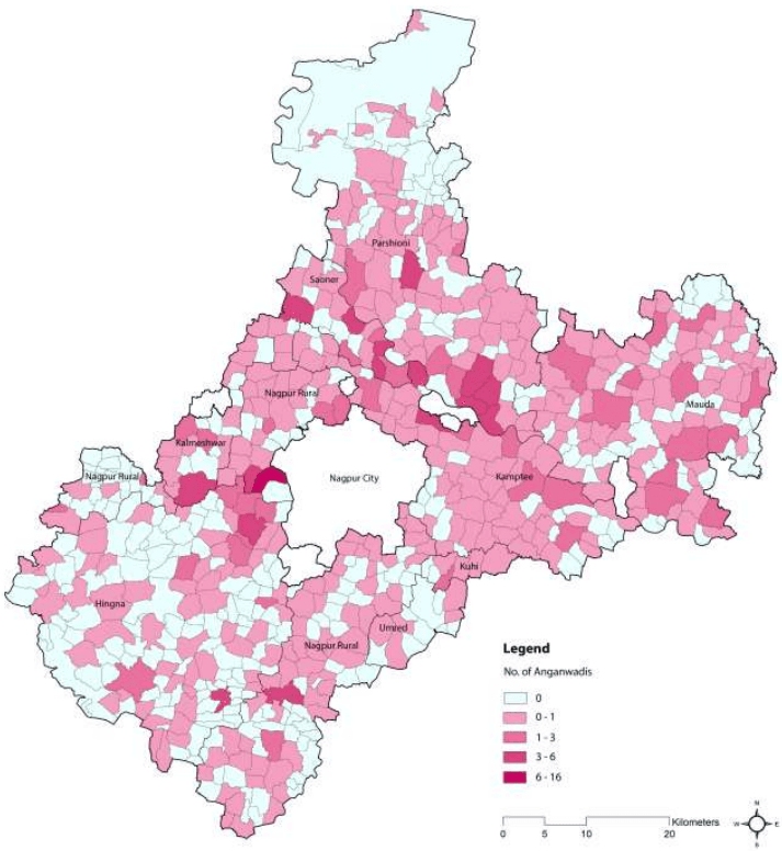
As per census 2001 and Integrated Child Development Services, there is at least one anganwadi in 390 out of 720 NMA villages. Out of the remaining 330, 131 villages have less than 100 population. Moreover, anganwadis are generally not present in urban areas which are catered by other categories of medical facilities. Figure 9-5 shows the distribution of anganwadis throughout the NMA.
The NMA has a wide coverage of government run medical facilities. Table 9-5 summarises the coverage of the facility in terms of the people it serves.
9-10
Table 9-5Summary of existing number of Sub centres, Primary Health Centres and Rural Hospitals
Facility
People it should serve ideally*
Number of existing facilities
Population (2001)
Number of people per facility (actual)
Sub centre
5,000
106
8,70,880
8,215
PHC
30,000
22
8,70,880
39,585
CHC
1,20,000
-
-
Rural Hospital
2,50,000
5
8,70,880
1,74,176
*Source: National Rural Health Mission
Figure 9-5: Distribution of Anganwadis in the NMA
It should also be noted that apart from the government run facilities there are privately run nursing homes and dispensaries, especially in the Census Towns, which increase the accessibility of people to health care facilities. A summary of existing health care facilities in Census Towns is given in Table 9-6. This includes health centre, hospital, dispensary, family welfare centre and nursing homes. It is observed that Hingna tehsil has the maximum number of health facilities as 74 followed by 9 in Nagpur rural tehsil, 5 in Saoner, 3 in Parsheoni and 1 in Kamptee tehsil within the NMA.
9-12
Table 9-6Summary of existing number of Health care facilities in Census Towns for NMA
Sr no.
Tehsil
Village
Health Centre
Hospital
Dispensary
Family welfare Centre
TB Clinic
Nursing home
Total
1
Hingna
Digdoh (Devi)
1
1
26
1
-
3
32
2
Hingna
Wanadongri
-
1
7
2
-
-
10
3
Hingna
Nildoh
1
-
20
1
-
-
22
4
Nagpur Rural
Wadi
1
0
5
0
-
1
7
5
Nagpur Rural
Davlameti
-
-
1
-
-
-
1
6
Nagpur Rural
Sonegaon (Nipani)
-
-
2
-
-
-
2
7
Parsheoni
Tekadi
1
-
-
-
-
-
1
8
Parsheoni
Kanhan (Pipri)
-
-
-
-
-
-
0
9
Parsheoni
Kandri
1
1
-
-
-
-
2
10
Kamptee
Yerkheda (Part)
-
-
1
-
-
-
1
11
Saoner
Chicholi (Kh)
2
-
-
-
-
-
2
12
Saoner
Sillewada
1
-
1
-
-
-
2
13
Saoner Total
Walani
-8
14
-63
-4
-0
-4
183
Source: District Census Handbook 2001
With increasing population densities in areas along the periphery of Nagpur City, there is need for better distribution of dispensaries and maternity homes for better access to primary health care.
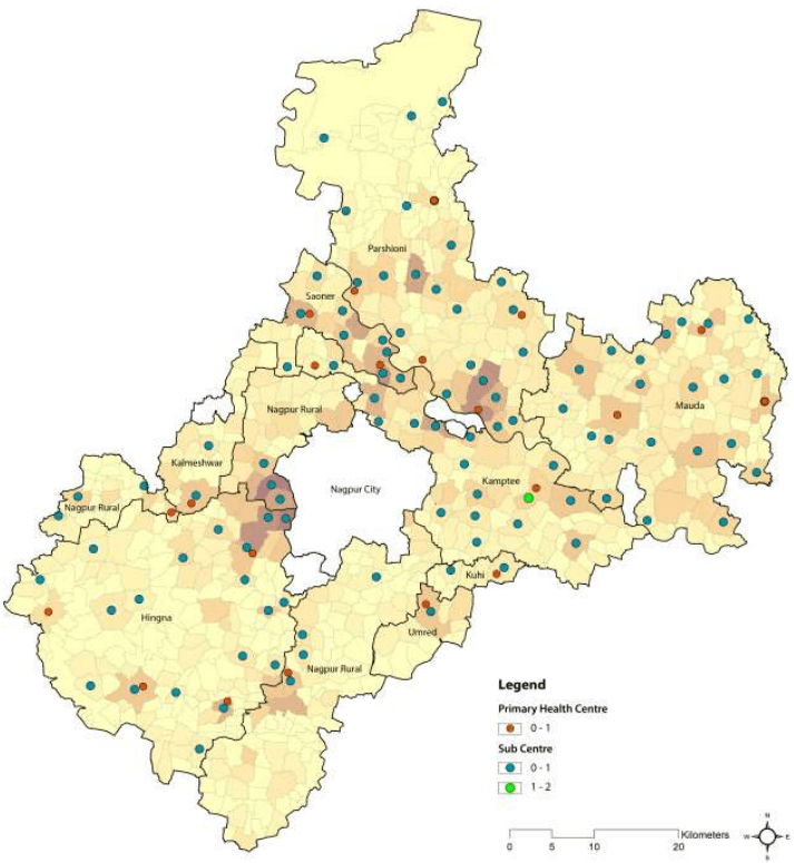
Figure 9-6 shows relationship between the most populous regions and availability of larger medical facilities such as the SCs and the PHCs.
Figure 9-6: Distribution of SCs and PHCs within NMA
9-14
9.3.2 Rural Hospitals
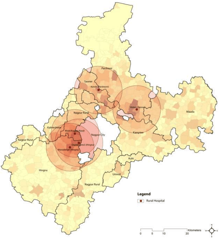
As per Census 2001 there are 5 rural hospitals in the NMA, namely at:
Kandri (Parsheoni)
Wadi (Nagpur Rural)
Digdoh (Devi) (Hingna)
Walani (Saoner)
Wanadongri (Hingna)
The norms stipulate provision of one rural hospital for 2.5 lakhs population. Although the current provision in terms of number of facilities is sufficient for the existing population as per the given norms, their distribution is not even resulting in issues of accessibility, particularly in areas along the south corridor. Figure 9-7 shows the distribution of rural hospitals in the NMA. Thus, there is a need to provide Rural Hospitals in regions which is far from the existing locations.
The presence of large private sector healthcare facilities in the NMA is lesser as compared to the public healthcare facilities. This could be primarily attributed to the fact that almost all of the private healthcare facilities are located in Nagpur City.
Figure 9-7: Distribution of rural hospitals within the NMA
9-16
9.2Education
At 88.39% the Nagpur District ranks third in literacy rate2in Maharashtra after Mumbai Suburban and Mumbai City. According to the District Statistical Abstract 2010, the District has 3,337 schools (Primary, secondary, senior-secondary schools together).
The Ministry of Human Resource Development (MHRD) has specified norms for provision of different educational facilities under the ‘Sarva Shiksha Abhiyan’ (SSA) Framework for Implementation, 2003. The norms stipulate that the student-teacher ratio should be maximum of 40:1. Table 9-1 gives the number of schools and colleges, the number of students and teachers employed for each category of educational facility in Nagpur District, demonstrating the overall standards of education in the District.
Table 9-1Number of facilities, attending students and employed teachers in Nagpur District
Number
No. of Students
No. of Teachers
Student-Teacher Ratio
Primary School
2,511
4,00,039
12,397
32:1
Secondary School
577
2,18,799
5,984
37:1
Senior Secondary School
249
2,18,989
7,189
30:1
Non-Technical College
368
1,12,504
3,842
-
9.2.1 Schools
There are a total of 684 primary schools in the complete tehsils within the NMA.3 There are 3,048 teachers teaching 83,076 students which gives a very favourable 1:28 ratio. There are 169 senior and senior secondary schools in the complete tehsils (See Table 9-2).
Table 9-2Existing Schools in the NMA (for full tehsils)
Tehsil
Primary Schools
Secondary Schools
Senior Secondary Schools
No.
Students
Teachers
No.
Students
Teachers
No.
Students
Teachers
Parsheoni
121
12,538
449
20
6,948
279
6
5,251
173
Mauda
139
12,424
544
18
5,848
181
9
7,848
207
Kamptee
132
20,081
658
25
10,944
358
10
11,588
264
Nagpur (Rural)
166
20,579
777
33
7,095
235
16
16,798
483
Hingna
126
17,454
620
21
6,869
214
11
7,718
225
Kalmeshwar
16
-
-
2
-
-
1
-
-
Kuhi
6
-
-
2
-
-
0
-
-
Saoner
33
-
-
9
-
-
8
-
-
Umrer
8
-
-
5
-
-
0
-
-
Source: District statistical abstract, 2010 & Census 2001
2Source: Census 2011
3 District statistical abstract of 2010 provides tehsil wise data only. Thus the detailed data provided henceforth is available for only the complete tehsils within NMA, namely Hingna, Kamptee, Mauda, Nagpur Rural and Parsheoni. The data for part tehsils is sourced from Census 2001, namely Kalmeshwar, Kuhi, Saoner and Umred.
The total number of students passing out of 1 2 t h standard can be an indicator of the demand for college seats and technical education seats. The total students passing out of 1 2 t h standard in 2010 (in complete tehsils under NMA) were 49,203 according to the District Statistical Abstract 2010. This accounts for around 28 percent of the total students within Nagpur District. Of all the students in the District passing out of 1 2 t h standard, Nagpur City takes the share of 56 percent.
Since the break-up of students of 1 2 t h standard across disciplines of commerce, arts and science is not available, assessment of the institutional capacities across NMA cannot be made.
9.2.2 Distribution of Primary Schools in the NMA
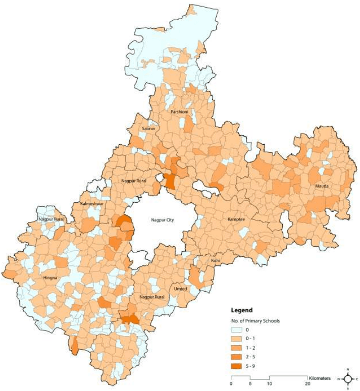
According to the census 2001 data, 554 out of 720 villages in NMA have at least one primary school. Figure 9-1 shows the distribution of primary schools within NMA. It is observed that the Census towns within NMA have more than one primary school.
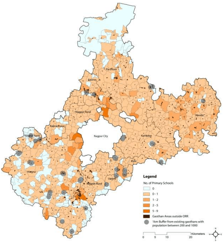
Of the 166 villages which do not have primary school, 141 have population less than 200. Only 25 villages with population in the range of 200 to 1,000 and do not have primary school. MHRD guidelines under SSA (Refer 9.2) stipulates that there should be a primary school within one kilometre of every habitation. For these 25 villages, one km buffer around the gaothan area was drawn to confirm the adherence to this standard. It was observed that there are 19 villages which do not fulfil this norm. Figure 9.2 shows 1 km radius from the gaothan area of the 25 villages. Village schools are generally located in gaothans; therefore if the 1 km buffer includes gaothan of a neighboring village, then it is assumed that direct access is available.
The villages with no primary school facility within 1km radius of its gaothan are:
Figure 9-1: Distribution of primary schools within the NMA
Figure 9-2: Populated villages with NMA which do not have direct access to a primary school
9-6
9.2.3 Distribution of Middle and Secondary Schools in the NMA
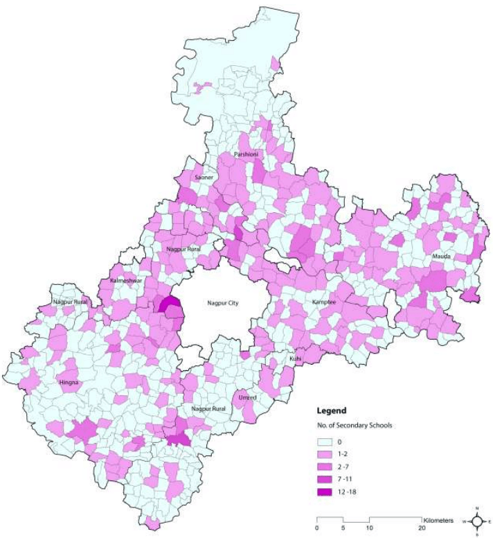
The middle, secondary and senior secondary schools were added to assess the existing provision of secondary schools in the NMA. Middle or secondary schools are available in 255 out of 720 villages of the NMA. With reference to 1979 government regulations on social amenities, population of at least 10,000 is needed to support a secondary school of capacity of 750 students. Considering that NMA population as per Census 2001 of approximately 8,70,000, there is a school for every 2,000 persons. Moreover, it was seen that the rest of the villages with no middle or secondary school, have a population of 3,700 or less. Hence, it can be reasonably concluded that the middle and secondary school facilities are sufficient in NMA at present. Figure 9-3 shows the distribution of the secondary schools over the entire NMA.
Figure 9-3: Distribution of middle and secondary schools within NMA
9-8
9.2.4 Higher education facilities
The complete tehsils under NMA have 78 colleges with the largest proportion concentrated in Nagpur (rural), Hingna, and Kamptee. Table 9.3 and 9.4 give an overview of the number of the colleges within various tehsils.
Table 9-3Colleges in NMA for full tehsils
Tehsil
No.
Students
Teachers
Technical and Professional Colleges
Engineering Colleges
Diploma
Degree
Colleges
Intake
Colleges
Intake
Colleges
Intake
Parsheoni
3
541
13
1
120
0
0
0
0
Mauda
4
854
30
0
0
1
225
0
0
Kamptee
22
5,167
195
1
120
2
660
0
0
Nagpur (R)
19
2,286
79
0
0
0
0
0
0
Hingna
12
1,680
67
1
120
4
2,200
8
3600
Total
60
10,528
384
3
360
7
3,085
8
3,600
Source: District statistical abstract, 2010
Table 9-4Colleges in NMA for part tehsils
Tehsil
Colleges
Industrial Training Centres
Kalmeshwar
0
0
Kuhi
0
0
Saoner
3
3
Umred
0
0
Total
3
3
Source: Census 2001
There are a total of 35 engineering colleges in Nagpur District with a total intake of little over 11,969. This offers a significant resource pool for the region. Of these 35 colleges, 8 colleges are within the complete tehsils under NMA with a total intake of 3,600. Besides these, there are 3 technical and professional colleges and 7 diploma colleges.
9.4Recreational and Entertainment Facilities
9.4.1 Overview
Nagpur district is rich in its biodiversity and natural heritage with the presence notable tourism sites such as wildlife sanctuaries, forts, temples and geological sites in close vicinity. Owing to its strategic location and being one of the major cities of Maharashtra, Nagpur is well connected by train, air and road with other parts of the State and the Country.
At the district level there are areas (outside NMA) which attract tourists from the entire region. The wildlife parks in the close vicinity of Nagpur district include the Kanha National Park, Melghat, Nagzhira, Umred Karhandla and the Tadoba-Andhari Tiger Reserve. There are organised excursions for Adasa, Khekranala, Markanda, Dhapewada, Nagardhan, Nawegaon Dam, Ramtek and Pavnar.
The Nagpur city forms an important context for NMA. It has number of destinations which attract tourists from the entire district such as Maharaj Baug and Zoo, Sitaburdi Fort, Bohra Masjid, Ambazari Lake and Garden, Telankadi Lake, Futala Lake, Telankhedi Hanuman Temple, and so on.
The total domestic visitor arrival in Nagpur district in 2009-2010 was estimated to be 4,013,137 which formed 4 percent of total domestic visitor arrivals in Maharashtra. The total international visitor arrivals in Nagpur district in 2009-2010 was estimated to be 9,754 which formed a mere 0.5 percent of international visitor arrivals in Maharashtra.
Based on the total visitor arrivals in the Nagpur district, it can be estimated that approximately 6,63,000 tourist arrivals were recorded for 2009-2010 4. This is further supported by observations of the ‘20 year Perspective Plan for Development of Sustainable Tourism in Maharashtra’ which estimated total tourist arrivals for Nagpur to be approximately 520,000 in 2003. These figures also indicate that tourist arrivals between 2003 and 2010 grew at a CAGR of 3.5 percent. Focused investments in the tourism sector in Nagpur district can catalyse the sector to a great extent and propel tourist growth even further.
9.4.2 Recreational areas and facilities within NMA
The recreational areas and facilities within NMA are categorised as follows:
Forest and parks
Lakes and dams
Religious institutions
Special facilities
4The break-up of visitors arriving by the purpose of their visit is not available for Nagpur district. Hence a proxy for Maharashtra state has been used wherein visitor arrivals for purposes of leisure (13 percent for domestic visitors and 20 percent for foreign visitors) have been considered to be most likely visit tourist locations.
9.4.2.1 Forest and parks
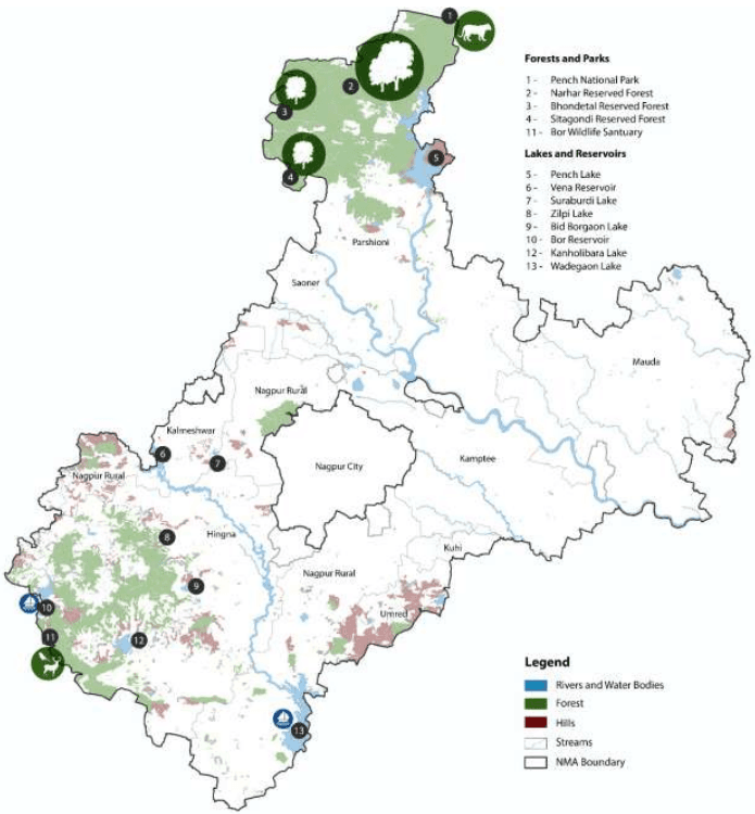
From the perspective a regional and national/international interests, the Pench national park and Bor wildlife sanctuaries, being home to Bengal Tigers, are a major attraction for wildlife tourism. The park is home to 33 species of mammals, 164 species of birds, 50 species of fish, 10 species of amphibians, 30 species of reptiles, and a wide variety of insect life. The Pench National Park and Tiger Reserve extends over an area of 257 sq. km. in the lower southern reaches of the Satpura hill ranges, along the northern boundary of Nagpur District, adjoining the northern boundary of NMA. The buffer area around the Pench National park lies within NMA covering around 243 sqkm. The buffer comprises of a number of smaller forests namely Narhar Reserved Forest (RF), Bhondetal RF, Sitagondi RF and Bhiwsen RF. The entrance to Pench National Park is from within NMA also.
The Bor wildlife sanctuary along with the dam on Bor River, is a very popular picnic spot. The sanctuary showcases a wide spectrum of wildlife, including sambhar, cheetal, barking deer, nilgai, tigers, leopards and wild dogs. It is situated 80 km away from Nagpur city in the south west part of NMA.
Gorewada International zoo covering an area of around 1800 hectares is planned in the vicinity of the Gorewada Reservoir. This zoo is expected to attract 1.5 million tourists per year and can fetch a revenue Rs.150 crore annually. The southern part of the zoo covering 800 hectares is being taken up as Phase 1. This will comprise of Indian and African Safari and a Bio park.
9.4.2.2 Lakes and dams
NMA region has many lakes, dams and reservoirs, along with rivers (Kanhan, Pench) and streams. These water bodies cover 224.91 km2 of area, which is 6.3 percent of the total NMA Region. The lakes which are more popular among visitors are Pench, Bor, Gorewada, Suraburdi, Zilpi, Wadegaon, Vena and Kanholibara. Among these, Wadegaon and Bor lakes have tourism related development around them. Mainly boating and fishing activities are carried out at such places.
9.4.2.3 Religious institutions
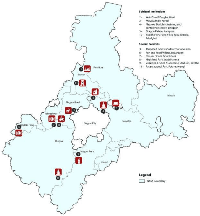
There are institutions of different religions in NMA. The more prominent are Dragon Palace Temple, Kuwara Bhimsen, Waki woods, Waki Sharif Dargha, Nagloka Buddhist training and conference centre, Takalghat Buddha Vihar along with Viktu Baba Temple, Koradi Devi temple.
9.4.2.4 Special facilities
Along with Religious and natural scenic tourist places, there are many entertainment places in NMA which are mostly privately run. Some of them are listed below.
Fun and Food Village and Highland Park are located in Nagpur Rural Tehsil along NH-6 which are famous picnic spots for young crowd.
Chokar Dhani, a Rajasthani Heritage Style Resort spread over ten acres of fully developed green land on a Hill Top near Wadi village on NH6. It is also the venue to host events like conference sessions, seminars, training programmes, workshops and weddings.
9-18
Vidarbha Cricket Association Stadium is located in the Jamtha village, about 15 km from Nagpur city. It is spread over 13 hectares. It has a capacity to seat 45,000 people. VCA Stadium features include media box, gym for players, VIP and corporate box. The venue also has world-class training and practice facilities.
Figure 9-8 and 9-9 show the major areas of interest and recreational facilities within the NMA.
9.4.3 Existing condition of tourism infrastructure
The quality of tourism infrastructure in the destinations within the NMA does not meet the standards prescribed by the National Tourism Policy 2002. The policy defines six broad areas of tourism infrastructure which include Swagat (Hospitality), Soochana (information), Suvidha (facilitation), Suraksha (security/protection), Sahyaog (cooperation) and Sanrachana (infrastructure). The Maharashtra Tourism Development Corporation (MTDC) has its regional office located in Nagpur city and has a tourist information service at the Nagpur Airport. The MTDC is also currently constructing its tourist orientation centre in Ramtek with an estimated cost of INR 2.4 million. However, the region requires additional tourist orientation centres strategically located at the entry points such as railway stations and bus stations.
Accessibility to the tourist hotspots is a critical issue with respect to promoting tourism in the area. Transportation connectivity to national parks within Vidarbha region is very low. Moreover, the state transport department has also terminated its connectivity to tourism destinations in Madhya Pradesh.
For tourism to develop as a key economic sector in the NMA, provision of improved tourism infrastructure is necessary along with an effective branding and marketing strategy.
Figure 9-8: Major natural features attractions within the NMA
9-20
Figure 9-9: Location of major areas of interest and recreational facilities within NMA
A discussion on the education infrastructure available within Nagpur City is warranted since the dependency on the city for higher education is high. It serves as a regional centre for education, where students from surrounding regions move to for higher education. There are 609 colleges affiliated to Nagpur University of which approximately 200 colleges are in Nagpur city and 103 are in Nagpur rural area.