11.1 Introduction
The NMA is a vast area with diverse uses, geographies, and functions. Yet it needs to function as a single entity in order for it to harness its strengths to create a vibrant centre for trade and commerce within the larger region.
The long term vision for the NMA is that of a vibrant place that provides a platform for healthy economic growth across the cross section of the urban rural transect.
This can be achieved by promoting quality urban space, preserving natural resources and farmland, promoting industries, tourism and allied activities, all to provide an even better quality of life to the residents of the region. Fundamentally, there are three working components of the above vision statement:
Economic growth
Environmental and natural resource stewardship
Development and integration of urban systems
The vision statement provides a sound basis for formulation of goals and objectives which provide a framework for the Development Plan.
In order to facilitate an environment which promotes healthy economic growth the plan would aim at facilitating quality urban spaces and infrastructure for the services sector, industrial manufacturing activity, tourism, and advanced technology. This will be supported with robust transport infrastructure (road and rail) and logistics facilities.
Objective 1: Allocate sufficient employment land (opportunity for industrial growth)
Goal 2: Efficient movement of goods
Objective 2: Minimize congestion on freight routes
Goal 3: Efficient movement of people
Objective 3: Address provision for quality public transport
The forests of the NMA are ecologically rich and sensitive areas which house a variety of flora and fauna. Rivers Pench, Kanhan, and Vena traversing the NMA provide ample fertile land resulting in rich agriculture activity. The concept plan aims at recognizing the eco-sensitive areas and non-renewable resources like its forests and farmland in the NMA to draw up a strategy to preserve the same.
11-1
Goal 3: Protect the natural environment
Objective 3: Maintain forest reserves, water bodies and natural corridors
Goal 4: Conserve resources
Objective 4: Protect agricultural lands for future generations
Goal 5: Reduce impact of natural hazards
Objective 5: Avoid habitation in flood prone areas
In order to facilitate high quality infrastructure for new developments, the plan will focus on compact development and prioritize key development areas. This will also enable the provision of housing closer to place of work and mix of uses and hence reduce travel distances, thus encouraging walkable urban environments. This, coupled with efficient public transport orientated to areas of development focus, will enable public access to areas of opportunity providing the ridership numbers for efficient functioning of the public transport system.
Goal 6: A balanced urban structure
Objective 6: Locate housing near jobs
Goal 6: Good supply of housing
Objective 6: Balance supply and demand
Goal 7: Minimize infrastructure costs
Objective 7: Optimise network lengths
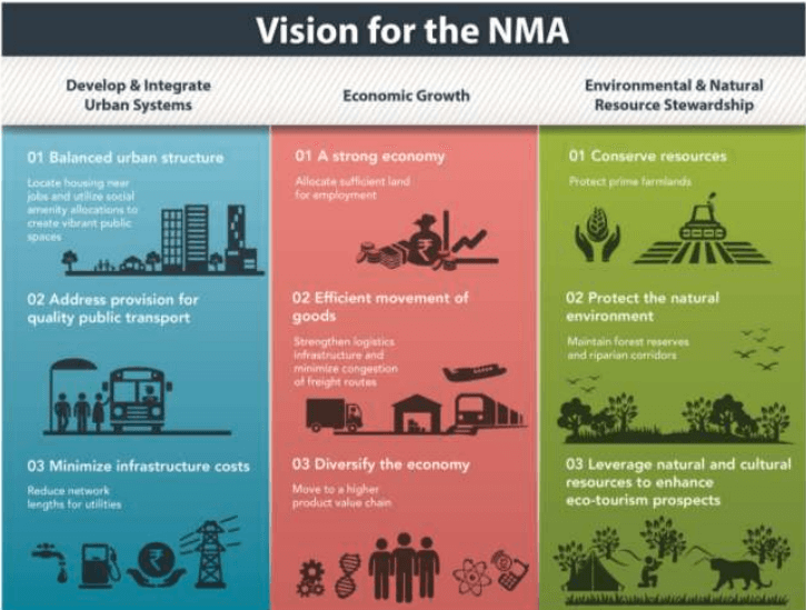
The Figure 11-1 summarises the vision and planning framework for the NMA.
11-2
Figure 11-1: Vision for the NMA
The goals and objectives are further developed into policy guidance that forms the backbone of planning proposals. It sets out a structure to help achieve the stated vision for the NMA.
The structure plan for the NMA has some key themes that basically revolve around the idea of growth management and the management of resources and potential future sprawl that might affect the region. Several strategies have to come into play to make the management of resources possible and the structure plan makes use of 4 key themes in that regard.
It is not sufficient to look at land use alone or transportation in isolation - these two components are very closely interlinked. There are numerous examples around the world which demonstrate that successful places are those which are able to establish a strong land use - transportation nexus. These two components have a long-term impact each other and uncoordinated land use – transportation decisions can lead to long-term mismanagement of limited resources and potentially unplanned growth that can be harmful to the success and growth of a region.
The NMA has a very strong network of key regional routes that provide for east-west and north-south connectivity through Nagpur. The proposed structure plan recognizes the conflicts that are generated by
11-3
the intertwining of regional connections and the need for local connections. Much of these conflicts come about because local streets are not enough to serve the range of land uses that are currently in place. So, while areas undergo land use transformation through the development process, which in this case is through the development plan, it will be equally important to develop, build and manage a network of roads that allows building connectivity for local people. This will be vital to ensure that the conflict between regional routes and local routes is minimized.
The current structure of the regional transportation framework consists of key regional routes that radiate away from Nagpur city. The outer ring road is regional level loop road that allows regional traffic to bypass the city. To effectively serve as a bypass, the outer ring road and the regional connectors need to be populated with uses that depend on and serve regional connections. For example: multi-modal stations, long distance transportation hubs, industrial areas and warehouses that depend on freight and cargo movements. Some of these key uses are located along the regional routes.
Effective functioning of regional routes warrants support of local connections. We also want to make sure that the regional connections we develop do not end up dividing places. A network of arterial and collectors integrates with the regional corridors to provide enhanced connectivity and in several instances across these regional corridors through at-grade junctions or grade-separated junctions are envisioned.
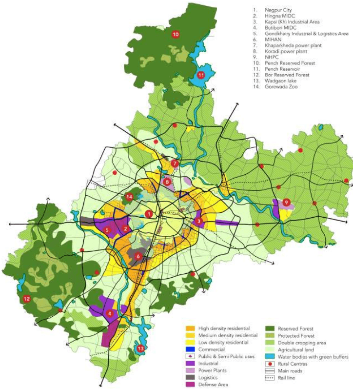
The pattern of streets and roads all lead to the core – the city of Nagpur. Because of the radial pattern, one of the key strategies of the plan is to focus on the “spokes” that lead into the city. The existing significant transportation investment that is taking place along these regional corridors, has lead to the adoption of a ‘corridors and wedges’ strategy which guides the Development Plan. This strategy allows the focus of development along key corridors and directs investment towards these corridors. The wedges are areas that are recognized as regional resources that are necessary to support investments in the region. Generally, neighbourhoods and housing, agriculture areas and farm land, environmentally sensitive areas, water catchments etc., are all a part of the ‘wedges’ in the NMA.
Even with the corridors and wedges strategy, the outer ring road plays a key role in providing a sense of boundary to the expanse of the urban agglomeration of Nagpur. We also recognize that there are parts of the city especially in the southern portions, the fringe areas of the city of Nagpur, which are currently witnessing intense new growth and development. The proposed structure plan recognizes these growth zones and allows these areas to grow in a relatively intense manner to allow the basic idea of promoting a compact development for the region.
One of the key benchmarks of a good quality sustainable development is a healthy scale of the jobs to housing balance, which means that within a given catchment area each job is served by corresponding housing. This implies that smaller the geography in which one is able to attain jobs to housing balance, the better is the sustainability performance of the place.
There are two key benefits to pursuing such a strategy. Firstly, there is a clear transportation benefit in the form of lesser trips and shorter trip lengths owing to close proximities of origins and destinations resulting in smaller commutes. The secondly benefit is of a better quality of life for residents measured through more time for recreation and work rather than long commutes and better environmental quality.
11-4
With regard to land use, it is important to locate employment and residential destinations close by. It is also important to intertwine live and work areas with for retail markets, public amenities and recreation activities. When such compatible uses are located close together a community's level of access increases significantly. Mix of land uses attracts more people and businesses together, fostering communication and collaboration within a community. It also promotes creation of compact, walkable, and transit friendly activity centres. It also helps reduce crime incidents by allowing ‘eyes on the street’. As a result, areas with mix of uses often attract higher property values. A key aspect of such developments is a range of commercial and residential unit sizes and options to accommodate different socio-economic classes.
The Development Plan has identified 4 to 5 key employment destinations as major employment locations like in Butibori, MIHAN, Hingna and industrial areas along the eastern corridor towards Bhandara. The Development Plan supports these key employment destinations by strengthening the residential and commercial uses in close proximity - through the proposed improvement scheme near MIHAN; through the planning of new residential areas as infill developments near Hingna and Kapsi-Khurd and so on. Apart from spatial planning and location of compatible land uses, this policy is reflected in the wide range of allowable activities under specific land use zones given the Development Control Regulations.
Open space and natural resource management is a key focus area of this plan. The NMA is very vast region which exhibits diverse range of land cover. Much of the land within the NMA is very fertile and vital resource for farming and agriculture. In fact, the large irrigation command areas of Pench allow for most of the portion within the NMA north of the Kanhan River to be used as a resource for agriculture with two or three crops per year. Rest of the un-urbanized portion of NMA too has good fertile soil even though it is not as yet irrigated. It is important to recognize that unless they are protected, reversing the fertile lands lost to sprawled development back to economic or agriculture related uses shall be impossible.
Besides agricultural land, there are several other resources within the NMA which are rich in their biodiversity. The development plan actively recognizes these areas and tries to weave these together by greenways, river buffers and open spaces to create an as connected network as possible of these natural resources. Wherever such natural resources interface with urban areas, the plan tries to bring about an open space strategy that allows for the transition of wilderness areas, farming land, greenway buffers, into areas that can be used as natural and open space resources for the urban community. This is done through a variety of open spaces like large-scale regional parks on the fringes of urban areas, large scale community parks and playgrounds, neighbourhood parks at a community level, and through the setting aside of amenity open spaces, playgrounds, and tot lots at the scale of localized developments.
Open space buffers along streams are an important part of this open space strategy. They essentially serve two main needs. Firstly, to manage and maintain natural waterways so that these can be kept open and not encroached upon for flood management and water quality management in the longer run. Secondly, they allow for continuous strips of open spaces that can be used as connections for domestic or wild animals, birds and other species and also at times where possible as off road connections between neighbourhoods through non-motorized means of travel through pedestrian connections and bicycle trails.
The NMA has several large water bodies that form a part of the natural resource and open space structure. These have been protected through the development plan by zoning tools that do not allow for future development in their subsidence areas. However, it is possible to consider these large areas as an amenity
11-5
and resource for regional open spaces and park spaces that can become a larger resource for the community.
Natural resource management and open space preservation strategy also has economic benefits in the form of management of agriculture land and its utilization as an economic resource. It also accrues benefits from active management and stewardship of natural resources and open spaces and forest areas for the potential of tourism and allied activities. Keeping this in mind, tourism centres and destinations have been planned for in areas of natural and cultural significance like the Pench national park, the Pench dam, the Waki sharif, Bor sanctuary etc. and such other areas.
The plan also hinges on the provision of social amenities as a key component of the development plan. It is important to be able to set aside land for key public facilities and social amenities that provide for everyday use and special occasions. Within the urban area, various social amenities have been identified in the form of education centers at a primary and secondary school level and higher education resources, potential locations for hospitals and healthcare facilities to meet future demands of a growing population within the NMA, and open space infrastructure as described above. Aside from these, several other social amenities have been provided for in the development plan, like the provision of community centres, cremation and burial grounds, vegetable markets, and utility infrastructure areas.
The distribution of some of these facilities in the rural parts of the NMA has been done taking into account the concentrations of populations in village clusters. So, rather than to provide for social amenities in every village or every other village, the decision to provide social amenities has been taken on the basis of the relative proximities of villages and those village clusters. One of the key assumptions behind this model is that social amenities at the NMA level will work in a hub and spoke format. This means that basic amenities are provided at a rural level and amenities of the next order are provided in urban centres. Tertiary level facilities that serve the larger region will be provided within Nagpur city or within its urban agglomerations and these will work together to help serve the larger NMA.
11-6
Figure 11-2: The Structure Plan