The overall strategy for allocation of land for future urban uses builds on the idea of growth management to prevent future sprawl and conservation of the region’s natural assets. A combination of five key themes have to come into play to achieve the broad outlined vision and goals for the NMA.
Jobs to Housing Balance and Mix of Uses – People should live close to work and within walking distance from community amenities
One of the key benchmarks of a good quality sustainable development is a healthy scale of the jobs to housing balance, which means that within a given catchment area each job is served by corresponding housing. It is also important to intertwine live and work areas with for retail markets, public amenities and recreation activities. When such compatible uses are located close together a community's level of access increases significantly. The Plan thus allocates several residential clusters that allow a range of mixed activities close to employment centers.
Land Use and Transportation Nexus - While areas undergo land use transformation a network of roads should be developed. This will enable local connectivity thereby minimizing conflict between regional and local routes.
Land use and transportation have a long-term impact each other and uncoordinated decisions between the two can lead to long-term mismanagement of limited resources and potentially unplanned growth that can be harmful to the success and growth of a region.
The Rural Urban Transect - Development intensity and typology should be managed by recognizing areas where future development is suitable and intended while preserving the natural, rural character of other areas.
The NMA is a vast area spreading across 3,567 km2, exhibiting areas with diverse characters. A transect based approach enables to clearly recognize certain areas where future development is suitable and intended while preserving the natural, rural character of other areas. This approach has led to the identification of seven existing character zones ranging from highly urban to rural to natural conservation providing a framework for managing the development intensity and typology across the NMA.
In the spatial development plan, the idea of the rural urban transect will be manifested through land use zoning proposals – thus, rather than having one residential zone with associated single FSI and ground coverage, there will be four residential zones R1, R2, R3 and R4 with highest intensity development (FSI) allowed for R1 and the lowest intensity development in R4. Areas close to Nagpur City, MIHAN, Hingna and areas along major nodes within the Outer Ring Road that are already witnessing development activity will allow higher intensity development.
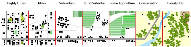
Figure 5: The rural-urban transect