This chapter discusses the existing utilities infrastructure provisions such as water supply, power, sewerage, drainage, telecom and gas in the NMA. The collated data is based on the available information from published reports, studies and interactions with various government agencies supported by observations during site visits. As discussed earlier in this report, the major urban areas such as the NMC, Kamptee and Kalmeshwar Municipal Councils and MIDC areas are outside the NMA extents. The areas within NMA are either developing rural areas or growing urban areas on the fringes of NMC and Municipal councils, which currently are not being serviced with utilities.
Much of the available information pertaining to utilities infrastructure is limited to the NMC and municipal council limits. The Nagpur District Regional Plan 1991-2011 broadly addresses the issue of infrastructure development in the new urban areas and rural areas within the metropolitan area.
This chapter covers a summary of key findings for various utility components in the NMC and municipal councils, supported by available information pertaining to growing urban and rural areas. Although the corporation and council areas are outside NMA boundaries, study of infrastructure provisions for these urban areas helps provide some background to that in the NMA.
8.1Water Supply
Water supply within the NMA and the larger region is sourced from surface and ground water sources. Based on the type and source of supply, the region can be categorised into three main categories:
urban areas including municipal corporation and municipal councils/ nagar parishads outside the NMA;
rural village settlements and census towns;
agricultural land
Water supply for urban areas is sourced from surface water sources like lakes, rivers and reservoirs to cater to the domestic, commercial, institutional, and industrial demands of city as well as ground water.
In the rural areas, water is being supplied through the rural water supply schemes implemented by agencies like the Zilla Parishad (ZP), the Maharashtra Jeevan Pradhikaran (MJP) or the Groundwater Survey and Development Agency (GSDA) that tap ground water by developing tube wells, hand pumps and bore wells. Surface water for domestic consumption is sourced from local water bodies or canals whereas irrigation of the agricultural land is being done through a combination of ground and surface water sources such as canals, tube wells and bore wells.
Water supply to the urban areas is dependent upon both surface and ground depending upon its availability. Details of major water sources available for the development of NMA are addressed below.
8.1.2Surface Water Sources
The total surface water runoff from the geographical area of Nagpur district is estimated to be about 4039 mcm, out of which about 984 mcm can be utilised for irrigation as well as other purposes. The catchments have only two perennial rivers that is Kanhan and Pench which confluence near village Bina. After this confluence, the Pench River merges into the Kanhan River, which is a tributary of the River Wainganga. There are some seasonal rivers like Kolar and Nag which are tributaries of the Kanhan River and contribute to Kanhan during monsoon. Vena is another main seasonal river which is tributary of the Wardha River. These rivers have been intercepted by constructing dams and runoff water from the catchments is stored and is used for irrigation as well as domestic and other purposes.
Nave Gaon Kheri and Totla dam projects are the two major projects in the region on the Pench River. The Right Bank canal of Pench project on Pench River which originates from Totla dam is the main source of water supply for the NMC and NMA.
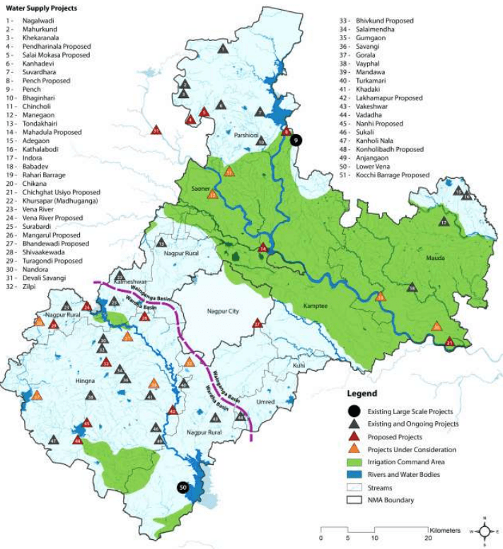
Kochi Barrage and Rehari barrage are two major projects in the region that are proposed on Kanhan River as shown in the Figure 8-3. The Rehari barrage is located near village Rehari at downstream of confluence point of Pench and Kanhan rivers. This was being considered as a potential source for Nagpur City, however the project was not undertaken by the NMC subsequently.
There are some smaller projects constructed on the seasonal rivers to store the run off to be used for irrigation purposes and for smaller developments. The Lower Vena project has been constructed on Vena River located near village Bela and Butibori. It has been designed to provide water for irrigation as well as drinking purposes in its command area. Existing and proposed potential surface water sources and tentative allocations of water from them are described in Table 8-3 and Table 8-4.
8-8
Table 8-3Potential surface water sources (existing) for the NMA
S No
Name of Scheme
Available Water (Total Live Storage)
Allocation of water for
Remarks
Drinking/Non Irrigation Uses
Industrial Uses
Irrigation Uses
mcm
mcm
mcm
mcm
1
Pench Project (Nave Gaon Kheri dam and Totla dam, constructed on Pench River) Full Water Levels (FWL): • Totla Dam – 490 m • Navegaon Kheri dam – 325 m Minimum Water Levels (MWL): • Totla Dam – 464 m • Navegaon Kheri dam – 31 4m
1,328.00
168.00
76.00
961.00
Water allocated for NMC from RBC at Mahadula: I. 112 mcm permanent allocation II. 78 mcm after paying to irrigation department about Rs. 100 crore Total allocation from Pench project is 190 mcm against 168 mcm planned non-irrigation water. Further, there would be no surplus water in pench project for future allocation to NMC/NIT. The “Pench Diversion” is another project proposed by the Government of Madhya Pradesh to tap pench river at upstream in the state of Madhya Pradesh to fulfil irrigation and non-irrigation demands of the state from this river in that region. Once the project is implemented, the surplus availability of water in Pench Project would be greatly reduced and only the allocated water from the Pench project would be available for allocated uses.
2
Lower Vena River Project: This project is constructed across the river Vena, a tributary of Wardha river located near
189.18
90.02
-
53.79
Total non-irrigation water allocation from the reservoir is 90.02 mcm and has been budgeted as follows: • Drinking water demand of Hinganghat and Sindhi towns of district Wardh – 7.27 mcm
8-9
S No
Name of Scheme
Available Water(Total Live Storage)
Allocation of water for
Remarks
Drinking/Non Irrigation Uses
Industrial Uses
Irrigation Uses
mcm
mcm
mcm
mcm
village Bella right near Buti Bori and river Nand.FWL:Badgaon – 255 mNand – 247 mMWL:Badgaon – 245.80 mNand – 241 m
MIDC Butibori area (MIDC)- 19.18 mcmDRDO - 0.18 mcmKesalapar – 0.015 mcmBarkhedi Railway – 0.54Ruch Soya Industries, Butibori – 0.21 mcmPurti power sugar factory – 1.31 mcmMIHAN - 26. 16 mcmIdeal Energy Power Centre-1 – 7.80 mcmVidarbha Industries – 12.35 mcmIdeal Energy Power Centre-2 – 10.00 mcmAparna Infra Energy – 5.00 mcmTotal budgeted water is 90.02 mcm. There is no additional water available for NMC/NIT.Source:Office of the superintending Engineer and secretary (Maharashtra-Madhya Pradesh interstate control board for Joint Hydel and Irrigation Projects) and the irrigation department
3
Kanholi Project:This project has been developed on the river Krishna.FWL: 314.24mMWL: 301.600m
22.213
-
-
20.485
No allocation for drinking and other non-irrigation uses.
8-10
S No
Name of Scheme
Available Water (Total Live Storage)
Allocation of water for
Remarks
Drinking/Non Irrigation Uses
Industrial Uses
Irrigation Uses
mcm
mcm
mcm
mcm
4
Upper Vena River project: This project is constructed on upstream of Vena river in Hingana TahsilFWL: 337.415mMWL: 330.405m
21.64
11.55
7.59
2.50
Out of 11.55 mcm, 9.9 mcm is allocated for MJP for rural and suburb water supply. There is no surplus water for future allocation. Also, many times the reservoir does not fill completely to provide the designed allocation of water.
5
Wakeshwar DamFWL: 275.69 mMWL: 271.29 m
2.07
2.07
-
-
0.2 mcm allocated for Sahara city and demand is 0.5 mcm. The balance water can be used for NMA
6
Kanhan intake works (at Kamptee)
Pumping
65.71 mcm (180 mld) allocated for NMC area and 4.38 mcm (12 mld) allocated for Kamptee municipal council.
7
Vishvasariya Barrage
100.00 (assumed)
100.00 (assumed)
-
-
The barrage has been abandoned, however if the river changes its course, the project can be revived as it has good water potential and can be considered as an important and sustainable source of water for future development
Source: Book of Progress and Current Status of Irrigation Projects in Nagpur District: Jal Sampada Department
8-11
This page is intentionally left blank.
8-12
Table 8-4Potential surface water sources (proposed) for the NMA
S No
Name of Scheme
Available Water
Allocation of Water for
Remarks
Drinking uses
Industrial uses
Irrigation uses
mcm
mcm
mcm
mcm
1
Kochi BarrageThe project has been proposed at Kanhan River near Kochi village in M.P.Maximum Water Level(MWL)318.00 mMaximum Draw Down Level (MDDL) - 311.00 m
75.07
5.39 (for rural water supply)
15.0 to MACB
48.48
The project has been approved and is under construction. There is no further scope to increase the size of the project and storage of water for further allocation.
2
Rehari BarrageA proposed scheme near Rahari village on Kanhan river in tehsil Mauda.The catchment area of the project is 11,753 km² Gross annual yield is 90% dependable - 3,172.41 mcmNet annual yield 90% dependable - 564.32 mcmGross storage at the barrage site - 65.86 mcmLive storage at the barrage site - 65.69 mcmMWL - 271mFull Resevoir level (FRL) - 270mReservoir bed level (RBL) - 251.1mCrest Level - 256m
128
128
-
-
175mld water is proposed for the NMC area as per 2011 demand and about 350mld water for the future demand in 2031. This scheme has been approved for implementation and was abandoned due to the shortage of funds.The project has a very good potential for tapping the flood water from the upstream catchments as well as perennial water flowing through the river and use it to cater to the water demands of the NMC and NMA areasThis project can be seen as a long term sustainable source for the region. The project, however, seems to be high in operational cost as the barrage is quite downstream of the region and the NMC.The operational cost of the scheme can be brought down by having an interdepartmental understanding with the irrigation department and the NMC/NIT. NMC/NIT may provide water from the barrage to irrigation department for irrigation purpose to the Downstream command area and in return receive water from irrigation department from the right bank canal from Pench project at higher elevation and transport it to the desired location of treatment by gravity.
3
Lakhma pur Irrigation project on local nallah
6.783
0.5
2.7
3.583
0.5 mcm water for Butibori water supply and 2.7 mcm water for MIDC area
4
Bhiv Kund SchemeConstructed on Local nallahFWL: 113.80 mMWL: 101.25 m
2.853
-
8-13
S No
Name of Scheme
Available Water
Allocation of Water for
Remarks
Drinking uses
Industrial uses
Irrigation uses
mcm
mcm
mcm
mcm
Preliminary study and survey work is in progress.
8
Savangi Project:FWL - 319.25mMWL - 311.50m
4.976
1.171
-
Water is yet to be allocated.
9
Nirgandi project to tap surplus water from Lower Vena during monsoon.Total proposed storage- 13.16 mcmTotal proposed utilisation-23.15 mcm
-
-
-
-
For irrigation use and rural water supply.
10
Vena Feeder: Mordham Nala is to be diverted to feed Upper Vena reservoir to contribute about 6 mcm water.
-
-
-
-
Currently the Vena reservoir is not filling up to its full capacity if rain fall in the region is less. Allocated water from the Vena project is not available to fulfil the desired demand in its command area.
11
Jamghat Project:The project has been proposed on Kanhan River in MP at Jamghat. The project has been formulated and the master plan has been prepared.Total water availability at the Jamghat HEP project would be 14.25 TMC (Thousand Million Cubic Metre) out of which:- 4.25 TMC (150 mcm) will be utilised by MP from Saledhana Reservoir/barrage; and- 10.00 TMC (353 mcm) will be provided to Maharashtra through canal.
This 353 mcm (970 mld) water would be available at high altitude and could be transported to Upper Vena reservoir by gravity for further storage and utilisation at the downstream. This project if commissioned may prove as a boon for the NMA and could fulfil more than half of the entire NMA demand including the NMC area.
Source: Book of Progress and Current Status of Irrigation Projects in Nagpur District: Jal Sampada Department
8-14
Figure 8-3 : Location of potential existing and proposed schemes for surface water sources
Data Source: Book of Progress and current status of Irrigation projects in Nagpur District: Jal Sampada Department; Map prepared by Halcrow.
8.1.1Ground Water Sources
Ground water is the main source of NMA area and is being developed by two types of abstraction structures; bore wells and dug wells. Dug wells are the main ground water abstraction structures with yield
8-1
varying from 20 to 380 m3/day. Minor irrigation census data (2000-2001) indicates that area irrigated by ground water is 914.68 km2 whereas surface water accounts for 241.74 km2 of area. It shows that the ground water is main source of irrigation in the NMA accounting about 73 percent of net irrigated area. The district has a total number of 59,407 irrigation dug wells, creating an irrigation potential of 1,413.71 km2 out of which 1,236.25 km2 of irrigation potential is utilised (Source - Nagpur Regional Plan 1991-2011).
The Government of Maharasthra (GoM) has developed a large number of bore wells fitted with hand pumps and electric motors for rural drinking water supply purposes in the district. Upto the year 2006-2007, the GSDA and the GoM have developed about 9,953 bore wells for rural water supply, out of which 9,483 are fitted with hand pumps and 470 with electric pumps (Source – MJP).
The NMA lies in the Godavari river basin contributing to the catchments of Waingangā River through the Kanhan River passing from the centre of the district. The Central Ground Water Board (CGWB) has conducted several studies in the district to understand the characteristics of ground water reserves in the region and assess the development potential of Nagpur. Salient features of ground water availability within the tehsils of the NMA are summarised in Table 8-1.
Table 8-1Salient features of ground water availability
Tehsil
EW
Wells OW
PZ
Depth (mbgl)
SWL* (mbgl)
Discharge (lps)
Draw-Down (m)
Zones (mbgl)
Parshioni
17
4
2
27.5-199.64
4.05-19.6
0.08-7.76
-
6.0-163.05
Hingana
2
3
-
85.4-234.8
14.68-27.65
0.5-21.33
-
-
Nagpur (Rural)
2
-
1
76.59-159.45
24.15
1.37-2.64
-
7.0-75.0
Mauda
2
1
-
174.5-187.25
1.0
1.37-4.43
25.06-42.58
34.75-147.65
Kamptee
6
3
-
29.93-202.45
4.53-16.45
1.37-8.85
-
11.0-140.4
Saoner
8
17
1
43.0-307
2.30-29.05
0.38-14.40
8.05-31.06
5.25-140.2
Kalmeshwar
9
4
79.3-278
4.55-28.5
0.38-17.92
5.6-11.95
28.0-107
Umred
2
2
67.5-200
3.64-5.07
0.01-2.16
24.0-122
Kuhi
4
3
36.5-200
-
-
-
5.0-99.75
Total
52
35
6
27.5-307
1.0-29.05
0.01-21.33
5.6-42.58
5.0-163.05
Source: Ground Water Information Nagpur District Maharashtra, Central Region Nagpur 2009
EW -Exploratory wells, OW - Observation wells, PZ – Piezometers, mbgl – metre below ground level;* SWL: Shallow Water Level
The depths of wells vary from 6.5 to 307 metres below ground level (mbgl) across Nagpur district and ranges from 27.5-307 mbgl within the tehsils of the NMA. Quantity of discharge varies between 0.01 and 38.5 litres per second (lps) across Nagpur district and 0.01 and 21.33 lps within the NMA. The deepest water level has been recorded at Pipla village in Saoner Tehsil that is 29.05 mbgl and the deeper aquifer zones have been encountered in many wells beyond 50 m depth, the deepest being at 287.73-296.57 m at Sillewada exploratory well in Saoner Tehsil.
Dynamic ground water potential in Nagpur District:
o Net annual ground water availability: 1041.89 million cubic metres (mcm)
o Annual ground water draft (irrigation - domestic): 452.95 mcm
8-2
8-3
o Allocation for domestic and industrial requirement up to next 25 years: 102.28 mcm
o Stage of ground water development: 43.47%
Source: Ground Water Information Nagpur District Maharashtra, Central Region Nagpur 2009
Ground water control and regulation assessment in Nagpur District:
o Over-exploited tehsils None
o Critical tehsils None
o Semi-critical tehsils Katol and Narkhed
o Notified tehsil None
Source: Ground Water Information Nagpur District Maharashtra, Central Region Nagpur 2009
Ground Water Quality
The available data also reveals that the water quality in many of the villages in NMA is affected by the presence in excessive quantity of nitrate (NO3), chloride (Cl), fluoride (F), iron (Fe) and total dissolved solids (TDS). Use of the water in a particular area can be decided after getting the water quality tested. Ground water quality in parts of Nagpur city is adversely affected by nitrate contamination, whereas in Kalmeshwar and Hingna MIDC areas the contamination of ground water in the phreatic zone has been observed due to discharge of industrial effluents (Ground Water Information Nagpur District Maharashtra, Central Region Nagpur 2009).
Prevailing Ground Water level in NMA
The CGWB periodically monitors the National Hydrograph Network Stations (NHNS) across the Nagpur district four times a year that is January, May (pre-monsoon), August and November (post-monsoon) to assess the dynamics of water levels in the district. Water level depths in the area in different seasons of the year have been described under the following subheads:
o Pre-monsoon (May-2007)
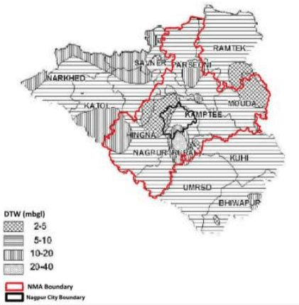
The depth to water levels in the district in May 2007 ranged between 2.00 mbgl (noted at VRCE, Nagpur) to 39.70 mbgl (noted at Panchgaon- PZ). Pre-monsoon water level depths across the district and within the NMA have been depicted in Figure 8-1. The studies show the shallow water levels within 10 mbgl in almost entire district and the shallowest water levels are observed near Nagpur city and area near Mauda. Water levels in the range of 10-20 mbgl are observed in the western and north western part of district in parts of Narkhed, Saoner and Katol Tehsil and isolated patches in Parshioni, Bhiwapur and Nagpur Rural Tehsil.
Figure 8-1 : Depth of ground water level (May 2007)
Source: Ground Water Information Nagpur District Maharashtra, Central Region Nagpur 2009
o Post-monsoon (Nov, 2007)
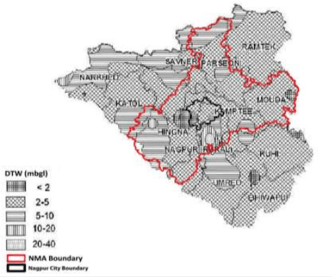
The depth to water levels in the district in November 2007 has been observed between 0.65 mbgl (noted at Waddhamna) and 28.65 mbgl (noted at Panchgaon-PZ). The spatial variation in post-monsoon depth to water levels is shown in Figure 8-2. In the entire district the water levels are shallow within 10 mbgl. The water levels of 2 to 5 mbgl is the most dominant range occupying major parts of Ramtek, Mauda, Kuhi and Bhiwapur Tehsils. Water levels of less than 2 mbgl are observed in isolated patches near Nagpur City and in parts of Mauda Tehsil. The northern peripheral part of the district from Narkhed to Ramtek Tehsil and two big patches in the middle portion covering parts of Katol, Hingana, Umred and Nagpur Rural Tehsils have deeper water level of more than 5 mbgl.
8-4
Figure 8-2 : Depth of water level (Nov 2007)
Source: Ground Water Information Nagpur District Maharashtra, Central Region Nagpur 2009
o Seasonal Water Level Fluctuation – (May to Nov 2007)
Rise in water levels has been observed in the entire Nagpur district and in major part of the district it has raised from 0.25 m (recorded at VRCE, Nagpur) to 11.05 m (recorded at Panchgaon - PZ). The rise in water level is mostly within 7.5 m. Major parts of the district covering entire Ramtek, Parshioni, Mauda, Umred, Hingna and Nagpur (Rural) show higher fluctuation of 4 m to 7.5 m. The western part comprising of Katol, Narkhed, Saoner and Kalmeshwar tehsil and Bhiwapur tehsil in the east have lower fluctuation of less than 4 m.
Ground Water Reserves in the NMA
The CGWB and GSDA have jointly estimated the ground water reserves of Nagpur district. Ground water reserves by tehsils and its use for different purposes have been presented in Table 8-2. The total annual ground water recharge in the district is about 1,102.27 mcm with the natural discharge of 60.38 mcm making 1,041.89 mcm water available for the annual extraction and for different purposes.
8-5
Table 8-2Ground water resources in the NMA by tehsil
Tehsil
Area Type
Net annual ground water availability (ha.m/yr.)
Annual Ground Water Draft (ha.m/yr.)*
Allocation for domestic and industrial requirement for next 25 years (ha.m/yr.)
Groundwater availability for future irrigation (ha.m/yr.)
Stage of Ground water development (%)
Category
Irrigation
Domestic and Industrial Uses
Total
Parshioni
Command
6822.35
638.09
218.53
856.62
437.06
5747.20
12.56
Safe
Non-command
1362.09
340.97
73.50
414.47
146.99
874.13
30.43
Total
8184.45
979.06
292.03
1271.09
584.05
6621.33
15.53
Hingna
Command
696.32
211.15
34.23
245.38
68.45
416.71
35.24
Safe
Non-command
7525.66
1857.59
401.93
2259.51
763.48
4904.59
30.02
Total
8221.98
2068.74
436.15
2504.89
831.93
5321.30
30.47
Nagpur (Rural)
Command
198.71
32.39
9.97
42.36
19.94
146.37
21.32
Safe
Non-command
6638.73
2427.29
369.17
2796.46
738.34
3473.09
42.12
Total
6837.44
2459.68
379.14
2838.83
758.28
8.1.3Short and Medium Term Availability of Fresh Water in NMA
Based on the observations on the dynamics of surface water in the region and its utilisation by different water projects (as shown in the Table 8-3 and Table 8-4), the medium term sources mentioned below can
8-15
be considered. These sources can fulfil the water requirement in the region during the development stages in addition to the existing uses and allocation from other sources.
Upper Vena River project: Upper Vena project can provide about 6.00 mcm water to the region can by diverting Mordham nala to feed upper Vena reservoir.
Lower Vena River project: Lower Vena lies close to the NMA boundary and can be considered as a potential fresh water source for medium term development of the region. Though the total water available at the Vena reservoir has been already allocated for different uses as mentioned in the Table 8-3 there may be some scope of a supplement/swapping arrangement. The wastewater to be produced near the command area of the project can be treated up to the desired standards and used for irrigation purposes in the command area and an equivalent amount of fresh water from the reservoir can be used for the domestic purposes in the surrounding areas of NMA.
Nirgandi project: This project has been proposed to tap surplus water from Lower Vena during monsoon. It can be developed for potable water supply as well as irrigation purposes. The availability of water is still to be ascertained.
Akoli Barrage: The project has been planned to tap water from Nag River which is basically untreated sewage from the Nagpur city during the lean period. About 50 mcm (140 mld) of water can be made available for the region for irrigation as well as domestic purposes by treating the water up to the desired standards. The river carries untreated sewage from the town and disposes it to Kanhan River at the upstream of the Kampti intake works. The water is polluted in the river and it becomes necessary to treat the sewage before its disposal in to the river.
8.1.4Long Term Availability of Fresh Water in NMA
As per the information shown in Table 8-3 and Table 8-4, following sources can be considered as long term and reliable water sources for the NMA:
Pench Project (Nave Gaon Kheri dam and Totla dam): This project is the backbone for the area and will continue to provide the allocated water for irrigation domestic and industrial purposes.
Vishvasariya Barrage: This is an existing barrage on the Kanhan River. The river has changed its course and the barrage is not functional. If the project gets revived due to the course of river it can produce about 100 mcm (275 mld) water for the region.
Rehari Barrage: This project has been proposed on the Kankan River near Rahari at the downstream of the proposed NMA. This project will provide about 128 mcm (350 mld) water to the region if commissioned. Operation and maintenance cost of the project may be higher due to high pumping head but it can also be brought down with inter departmental understanding with NIT/NMC and irrigation department as mentioned in Table 8-4 If commissioned and proper O&M is assured, this project may prove to be boon for the region.
8-16
Jamghat Project: The project has been proposed on Kanhan River in Madhya Pradesh at Jamghat. The project has been formulated and the master plan is ready. This project would provide about 10.00 TMC (353 mcm/970 mld) fresh water to Maharashtra if commissioned. This could be an ultimate fresh water source for the region and could contribute to more than half of the total demand in NMA including NMC.
This water could be transported by gravity up to the water treatment plant site closest to the development area and would safeguard huge energy by avoiding pumping requirements.
8.1.5Existing Water Supply Mechanism in Nagpur District
The Maharashtra Water Supply and Sewerage Board (MWSSB), Rural Development Department, Zilla Parishad, Jeevan Pradhikaran Nigam, Environmental Engineering Department (EED), MIDC, NMC, and the State Irrigation Department are the government agencies responsible for the supply and development of water in the district. The Irrigation Department does not have any direct role in water supply though it supplies bulk quantity to MWSSB, MIDC and NMC from the dams constructed for irrigation purpose. Zilla Parishad is involved in small rural water supply schemes and Environmental Engineering Department implements the large rural water supply schemes. These agencies develop water resources to suit their individual requirements.
Within the NMA, the existing water supply schemes are mainly dependent on ground water sources like tube wells, bore wells, hand pumps etc. As per Nagpur District Regional Plan 1991-2011 Part - I, the EED and Zilla Parishad are mainly involved for preparation of water supply schemes. Scheme costing less than Rs 10 lakh are implemented by Zilla Parishad and more above are implemented by EED.
As discussed with the Irrigation Department (Pilot Project), 15 percent of the irrigation water from the irrigation schemes (storage created at the dam sites) is allocated for drinking purposes and the allocation is considered from the planning stages of the schemes.
8.1.7Existing Rural Water Supply Status in the NMA
Existing water supply in rural areas is mostly dependent on the ground water reserves and few of the villages situated in suburbs are covered by regional water supply schemes. The Zilla Parishad and EED are engaged in preparation and execution of water supply schemes in rural areas. Departments that are responsible for planning and implementation of the schemes in the region have implemented a large number of water supply schemes based on different sources. The different water supply schemes in rural areas of the NMA have been summarised by tehsils in the Table 8-9.
8-21
Table 8-9Existing rural water supply status in NMA
S No
Block
No of villages
Total population
Water Supply Status and water sources
Total no of individual PWS
No. of functional individual scheme
No. of working stand post
No. of hand pump
No of functional hand pump
No. of Public well
No. of Public well actually used
Total water supplied with PWS in litres per day
Regional PWS
Fully covered block
1
Parshioni
113
158949
87
79
481
460
374
239
230
4500341
0
2
Hingna
134
208355
110
110
777
682
566
392
390
5449320
18
3
Nagpur
141
223130
135
119
381
1034
941
320
75
482655
12
4
Mauda
119
151629
87
84
628
545
429
451
8.1.6Existing Water Supply Scenario in the Surrounding Municipal Corporation and Councils
Nagpur Municipal Corporation
o Water Supply Sources for the NMC
The main sources of water supply for NMC are the Kanhan River and right bank canal of Pench project. Water for the Nagpur city is drawn from the following three surface sources:
- Gorewada Tank
一 Kanhan river
Pench canal
Ambazari Lake and the Vena irrigation tank are used for supplying water to the MIDC area, defence area and its surroundings respectively. The NMC produces about 582 mld of treated water from the different surface water sources. Table 8-5 indicates the present supply to the city from
8-17
different sources and capacities of water works and Table 8-7 below indicates the command areas of water supply by various sources in NMC.
Table 8-5Present treated water supply in NMC and capacities of Water Works
S No
Name of Water Works
Supply (mld)
Capacities of Water Treatment Plants
A
Surface Source
1
Old Gorewada WW
16
16
2
Kanhan WW
170*
240*
3
Pench Phase - I
136
136
4
Pench Phase - II
140
133
5
Pench Phase - III, Stage-I
120
118
Total
582
643
* After modification of Kanhan water works 170 mld (120+50). Capacity of WTP has been increased to 240 mld
Source: 1) MJP Project Report – May’98 / Master Plan for Water Supply: TCE Consulting Engineers Limited.
DPR on rehabilitation plan to implement 24x7 water supply project for Nagpur city- Dinesh Rathi and Associates 3) City Sanitation Plan report, March 2011, NMC
8.1.8Existing Water supply for irrigation in Nagpur district
The Nagpur district has a total geographical area of 9,931 km2 out of which 709,500 hectare is cultivable area. The total surface runoff from the geographical area of the District is estimated to be about 4039 mcm out of which about 984 mcm can be utilised for surface irrigation purposes by construction of dams, canal systems and lift irrigation schemes.
Irrigation schemes (medium irrigation and minor irrigation schemes in both state and local sector) with irrigation potential of 68,867 hectare, have been completed as on July 1990 contemplating use of 565 mcm of surface water.
After the completion of all feasible schemes (utilising 984 mcm), the area that can be brought under irrigation will be 2.68 lakh hectare from surface water resources from the District which is covered by Wardha and Wainganga basins. The future available source of water for the District from river Wardha and Wainganga is 4,031 mcm and 10,872 mcm respectively.
There are many other small tributaries also in the district namely Warna, Jam, Kar, Kanhan, Pench, Kolar, Bawanthari, Sur and Gaotala and have been taped by constructing small irrigation schemes for the irrigation uses. By end of June 1990, 941 projects of irrigation schemes were completed with a potential of 154,066 hectare in the district. Full surface utilisation of 2.68 lakh hectare of land was proposed to be achieved by providing and completing various irrigation schemes. Position of completed irrigation schemes in the District as on 30 June 1990 have been given in the Table 8-10.
Table 8-10List of completed irrigation schemes
S No
Type of irrigation scheme
No. of schemes completed
Net irrigation potential in ha
1
Major Projects
1
83,076
2
Medium Projects
15
6,257
3
Minor (state sector)
114
43,677
4
Minor (Local Sector)
811
21,056
-
2.853
There is no surplus water at this source for future allocation
5
Salai (Mokasa)Minor Irrigation project, constructed on tributaries of Kanhan river
2.143
-
-
2.143
There is no surplus water at this source for future allocation
6
Makardhokara project:FWL: 298.10mMWL: 291.50m
18.921
5.685
-
8.506
There is no surplus water at this source for future allocation
7
Akoli Barrage planned at Nag River
50 (assumed)
50 (assumed)
-
-
Nag river is contaminated due to the disposal of untreated sewage from the Nagpur town. This water can be tapped by constructing barrage at Akoli and treated up to the irrigation standards. The treated water can be used for the irrigation purposes in the command area of pench project and fresh water can be allocated for the drinking purpose from the pench project at higher elevations. Nag water can itself be treated up to the drinking standards by providing a proper treatment plant and supplied for domestic purposes.
3619.46
41.52
Mauda
Command
13711.98
1412.33
365.84
1778.17
731.67
11567.98
12.97
Safe
Non-command
373.80
88.68
43.93
132.61
87.86
197.26
35.48
Total
14085.78
1501.01
409.76
1910.78
819.53
11765.24
13.57
Kamptee
Command
5718.60
1605.01
339.00
1944.01
677.99
3435.60
33.99
Safe
Non-command
705.99
380.12
57.47
437.59
114.94
210.93
61.98
Total
6424.59
1985.13
396.47
2381.60
792.93
3646.53
37.07
Saoner
Command
3160.42
994.03
67.98
1062.01
92.16
2096.63
33.60
Safe
Non-command
3681.17
3467.50
275.84
3743.33
180.25
725.84
101.69
Total
6841.59
4461.52
343.82
4805.34
272.41
2822.47
70.24
Kalmeshwar
Command
334.78
349.73
14.64
364.37
5.48
2.05
108.84
Safe
8-6
Tehsil
Area Type
Net annual ground water availability (ha.m/yr.)
Annual Ground Water Draft (ha.m/yr.)*
Allocation for domestic and industrial requirement for next 25 years (ha.m/yr.)
Groundwater availability for future irrigation (ha.m/yr.)
Stage of Ground water development (%)
Category
Irrigation
Domestic and Industrial Uses
Total
Non-command
6839.21
5014.18
302.17
5316.34
572.95
1276.74
77.73
Total
7173.99
5363.91
316.81
5680.72
578.43
1278.79
79.18
Umred
Command
1252.81
163.79
107.69
271.47
208.58
880.45
21.67
Safe
Non-command
8876.41
1643.17
324.42
1967.59
648.84
6584.40
22.17
Total
10129.23
1806.96
432.10
2239.07
857.42
7464.85
22.10
Kuhi
Command
438.53
123.68
30.13
153.81
60.25
254.60
35.07
Safe
Non-command
7189.16
2189.78
472.05
2661.83
944.10
4055.28
37.03
Total
7627.69
2313.46
502.18
2815.64
1004.35
4309.88
36.91
Total
Command
32334.5
5530.2
1188.01
6718.2
2301.58
24547.59
22.19
Safe
Non-command
43192.22
17409.28
2320.48
19729.7
4197.75
22302.26
54.74
Total
75526.74
22939.47
3508.46
26447.9
6499.33
46849.85
43.47
Source: Ground Water Information Nagpur District Maharashtra, Central Region Nagpur 2009; *hectare metre/year
8-7
331
4708910
12
5
Kamptee
76
125100
78
78
510
558
468
137
115
2709268
3
Partially covered block, villages covered in the project area
6
Saoner
27
89577
30
30
249
95
95
24
22
1962750
0
7
Kalmeshwar
21
19439
17
17
90
76
69
23
23
133000
0
8
Umred
10
12068
9
8
27
20
20
17
15
314500
1
9
Kuhi
07
5570
7
7
32
43
43
9
9
122000
0
Source: Data collected from Zilla Parishad
8-22
o Present Water Allocation from different sources to the NMC
Total allocation of water for the Nagpur city is about 261.51 mcm from the different sources as mentioned in the table below, out of which NMC is already drawing about 246.80 mcm fresh water.
Table 8-6Water sources for NMC
Sr No
Sources
Quantity allocated
Actual withdrawal
mcm
mld
mcm
mld
1
Kanhan Intake work at Kampti
65.71*
180.00
65.71*
180.00
2
Pench Project (PRBC) from Mahadula
112.00(Permanent allocations)
306.88
174.29*
477.50
78.00to be procured by NMC
213.72
3
Gorewada Lake
5.80
16.00
6.80
19.00
Total
261.51
716.6
246.80
676.50
Source: 1) DPR on rehabilitation plan to implement 24x7 water supply project for Nagpur city- Dinesh Rathi and Associates 2) Nagpur Municipal Corporation. * NMC data
Amba Kheri Lake having storage capacity of about 3.67 mcm also lies with NMC and NMC can integrate this water with city water supply though the quantity is less.
8-18
There is no other potential water source available in the region to provide fresh water to the NMC or NMA. NIT/NMC has to be dependent either on the proposed schemes or have to develop new sources for long term development of the NMA.
Existing Water Distribution System in the NMC
The existing water distribution system of Nagpur city consists of piped network of about 2100 km of which has been broadly divided in to three areas:
- North / east / south part of Nagpur city with water supply from Kanhan Head Works and WTP;
North / west / south / central part of Nagpur city with water supply from Pench project and WTP at Gorewada;
North / central part of Nagpur city with water supply from both the sources i.e. Pench and Kanhan
The total city area has been divided into ten water supply zones for better operation and maintenance. Water is supplied to the city by Master Balancing Reservoirs at Seminary Hills (SH) and Government Houses (GH). The population, service area, and approximate water supply to respective zone are given in Table 8-7.
Table 8-7Water supply service areas within NMC
S No
Zone
Population (2004)
Area (Ha)
Quantity of water supplied (mld)
1.
Dharampeth
261,666
4084.63
78.55
2.
Laxmi nagar
257,960
3516.31
54.05
3.
Hanuman nagar
165,717
2181.52
27.91
4.
Dhantoli
236,701
815.37
36.16
5.
Nehru nagar
198,411
1423.69
27.22
6.
Sokta bhawan
290,076
556.07
61.03
7.
Satranjipura
336,267
744.48
91.98
8.
Lakhadganj
176,716
2406.16
16.04
9.
Ashi nagar
225,881
3225.02
23.14
10.
Mangalwari
204,606
2109.06
44.26
11.
Pumping/feeder main Total
2,354,001
21,062.00
29.65490.00
Source: DPR on rehabilitation plan to implement 24x7 water supply project for Nagpur city- Dinesh Rathi and Associates -Water Audit and leak detection Report March 2004
As per the population projections, the city is expected to attain a population of 4.75 million by the year 2031 (Source: 24x7 water supply project for Nagpur city). NMC has taken enough initiatives and actions to augment
8-19
the existing system to supply adequate water to the consumers and several new schemes have been propose for the implementation in the near future.
Based on the statistical analysis conducted by NEERI and the standards recommended by the Central Public Health and Environmental Engineering Organisation (CPHEEO) manual on water supply, the domestic water supply (lpcd) rates adopted for different housing categories in Nagpur for the present conditions are indicated in Table 8-8. In Nagpur, the domestic water supply on an average is not more than 130 lpcd, whereas in outer skirts of Nagpur city it is even less than 40 lpcd.
Table 8-8Adopted water supply rates by housing category
Water Supply Category
Water Demand (lpcd)
2001
2011
2021
2031
Residential area other than slums (HIG)
170
180
190
200
Residential area other than slums (MIG)
150
160
170
180
Residential area other than slums (LIG)
100
110
120
130
Slum area through distribution system
100
100
100
100
Public stand post
40
40
40
40
Source: Master Plan for Water Supply, Nagpur Municipal Corporation, September 2000
Kamptee Municipal Council
Kamptee Municipal council is receives water from an existing intake well on the Kanhan river. The total yield of water lifted from intake is 12 mld against the 10 mld demand of the town. The demand is based on 100 lpcd water supply for Kamptee town and 55 lpcd for villages close proximity to the town i.e. Ranala, Yerkheda, Gada, Ajjani and Ghorpad. A raw water transmission main of 610 mm diameter in a length of about 7.0 km has been laid from intake pump house to water treatment plant (WTP) of 15 mld treatment capacities.
Total length of the existing water supply distribution network is about 82 km with the construction material of CI, DI and PVC. Water is supplied to the town with the help of an existing GLSR of capacity 1.2 million litre capacity and three Over Head Storage Reservoirs (OHSRs) of capacities 0.26, 0.9 and 1.5 milion litres each.
Kalmeshwar Municipal Council
Water is pumped to Kalmeshwar from Itangoti Village Lake which is about 20 km away from the City. The total yield of water from this lake is 3.0 mld. Other source of water supply to the town is ground water and about 3.8 mld water is being extracted from six number of bore wells and three number of tube wells to cater to the demand of the town. Total length of distribution system is around 15 km.
The city receives an alternate day’s water supply due to less shortage capacity which is about 5.4 million litres in three OHSRs. Three new OHSRs of capacities 0.115, 0.1, 0.8 million litres have been proposed to augment the storage capacity.
8-20
5
Lift irrigation schemes Total
-941
-1,54,066
Source: Nagpur Regional Plan 1991-2011
8.1.10Demand Supply Gap from the Potential Water Sources
The demand and gap assessment in water supply has been illustrated in Table 8-12. The assessment is made on the basis of existing and proposed water schemes to fulfil future demand. It is considered that partial demand will be fulfilled by private owners through individual bore wells/tube wells, however this is not accounted in this assessment.
Table 8-12Total supply of water from existing and proposed schemes and demand by year
S No
Description
Year-wise supply and demand
2011
2021
2031
1
Existing Schemes
Pench project
396
396
396
Kanhan water works
180
180
180
Old Gorewada
16
16
16
2
Proposed Schemes
Pench Project. Phase-III, Stage-II
113
113
113
Kochi Barrage on Kanhan Rivers
-
108
108
Rehari Barrage on Kanhan Rivers
-
175
350
Total Supply (including distribution losses)
695
978
1153
Total Demand (within the NMC limits)
532
709
934
Total treated water demand including NMC limits, fringe area and special projects (CIDCO and MIHAN)
558.72
738.38
987.8
Total raw water demand including NMC limits, fringe area and the special projects (CIDCO and MIHAN)
690(252 mcm)
915(334mcm)
1,222(446 mcm)
8-24
The table shows that there is likely to be surplus water which can be made available for the future growth within the NMA.
8.1.9Ongoing and Proposed Water Supply Projects
Nagpur Municipal Corporation
NMC has prepared the master plan for water supply to meet the water supply up to 2031 from identified sources. The proposed schemes for the supply of water for irrigation as well as for the city are Rahari barrage and Kochi barrage on Kanhan River. The development need of water supply for the city up to the year 2031 would be met from these future potential schemes. Year wise development of the water supply sources for the city water supply is presented in Table 8-11.
8-23
Table 8-11Proposed water supply sources for NMC and their capacities
Sr No
Source
Year wise cumulative capacities(mld)
2011
2021
2031
1
Pench Stage III Phase II (mld)
113
113
113
2
Rahari Barrage 30 kms from Nagpur City
-
175
350 (128 mcm)
3
Kochi Barrage, 33 kms from Nagpur City Total
-113
108396
108571
Source: Master Plan for Water Supply, Nagpur Municipal Corporation, September 2000
Rural Water supply
The rural water supply schemes of villages are implemented by three departments – The MWSSB, ZP and GSADA. MWSSB implements schemes costing above INR 5.0 lakh, ZP implements schemes costing less than INR 5.0 lakh and GSDA implements the bore well program. A total of 151 of 726 villages of the NMA have been selected by the ZP under the annual action plan for the year of 2011-12 for the development of water supply schemes. Details for this have been summarised in Annexure 8.