The primary goals of the Disaster Management are to reduce the likelihood that the City will experience disaster and to mitigate the impact of any disasters that do occur in the City. Intensity of disaster can be reduced by identifying and correcting hazardous conditions by encouraging alertness in detecting and reporting. This calls for a preliminary identification of the major disasters affecting the city and the areas prone to disaster. The Kerala State Action Plan on Climate Change was drafted by the Directorate of Environment and Climate Change (DoECC) with relevant departments, agencies and institutes providing inputs. This was endorsed by the Government of India in 2014. The Ernakulum city currently holds a Disaster Management Plan prepared in the year 2015 by Kerala Disaster Management Authority. However, events like the flood of 2018 and unpredictable climactic events that may occur in the future owing to climate change needs to be considered while planning for the Kochi city.
Climate change effects in Kochi
The effects of climate change on the Earth’s environment will be manifested most directly through four mechanisms. First, although some anomalies are to be expected, most climate experts agree that human-induced climate change will increase average global atmospheric and sea surface temperatures. Second, temperature increases will be associated with changes in precipitation patterns worldwide. Third, changes in storm tracks and intensities are likely to occur. Fourth, the sea level is expected to rise due to a combination of thermal expansion and the melting of mountain glaciers and the polar ice caps. Although most climate change forecasting models imply relatively gradual changes in these regards, it is widely agreed that climate change is likely to be accompanied by increased climate variability and by an increased risk of extreme events and surprise2.The draft report of the United Nations Intergovernmental Panel on Climate Change released in 2019 , which warns of devastating rise in temperature and sea level, has raised concern about possible inundation of Kochi with the global sea level rise ranging from 0.5 – 2m for the next century, as the elevation from sea level is less for Kochi.
The major impacts of this would be
615
• Loss of large chunks of urban and rural areas in Cochin.
2Possible Vulnerabilities of Cochin, India, to Climate Change Impacts and Response Strategies to Increase Resilience, June 2003, Oak Ridge National Laboratory and Cochin University of Science of Technology
Kochi Municipal Corporation
DISASTER MANAGEMENT
• Increased chances of coastal flooding and water logging along with intense storm events which might even affect structural stability of buildings.
• Loss of tourist places and thereby economic and livelihood support gained from them.
• Salt water intrusions in both surface and ground water along with loss of fertile lands
• Increase in temperature which would cause higher demand for potable water and electricity for cooling.
• Negative impact on the fishes and corresponding fisheries community.
Combination of change in temperature and precipitation can change local human and natural ecologies, like for example impacts on human health with changes in pests and pathogens to which people are exposed and the associated health requirement.
22.2.1Sea level rise
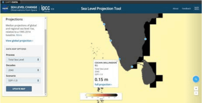
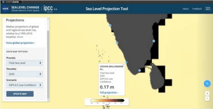
The recent IPCC (Intergovernmental panel on climate change) study released in 2021 gives out a much more alarming picture for Kerala and especially Kochi. Based on the report by NASA it expected that 12 coastal cities of India may be submerged by the end of the century due to climate change. These cities may be filled with sea water upto 3 feet as per the projections. The sea level projection tool developed by NASA predicts the following.
NASA has developed a projection tool (https://sealevel.nasa.gov/ipcc-ar6-sea-level-projection-tool ) and distilled the report for policy makers. In Kochi Willington island is considered as the base station. There are 5 SSP scenarios (Shared Socio economic pathways). The greenhouse gas concentrations for these 5 scenarios with different future socio-economic projection and political environment are considered. SSP1-1.9 aims for a world with green growth (sustainable environment) whereas SSP 5-8.5 depicts the worst case scenario with no control over usage of fossil fuels. On an ideal level , SSP1-1.9 is the best scenario but the highest priority is given to achieve the SSP 1-2.6 scenario which reflects close to the target 1.5oC under Paris agreement. ‘SSP 1-2.6 low confidence’ is the worst case exclusive to that category.
Kochi Municipal Corporation
DISASTER MANAGEMENT
Figure 22:1 A rise of 0.15m predicted for 2040 in best case scenario (SSP1-1.9) Source : sealevel.nasa.gov/ipcc-ar6-sea-level-projection-tool
Figure 22:2 A rise of 0.17 m predicted for 2040 in worst case scenario (SSP5-8.5) Source : sealevel.nasa.gov/ipcc-ar6-sea-level-projection-tool
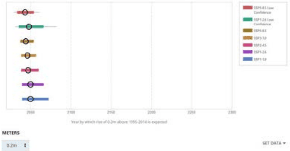
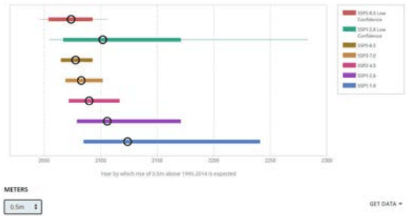
The figure below shows a confirm rise in sea level of 0.2 m on reaching the year 2050 in all scenarios and Figure 22:4 shows a sea level rise of 0.5 m in a gap between 2050 to 2100.
Kochi Municipal Corporation
DISASTER MANAGEMENT
Figure 22:3 0.2m sea-level rise expected at 2050
Figure 22:4 0.5 m sea-level rise expected at a gap of 2050 to 2100
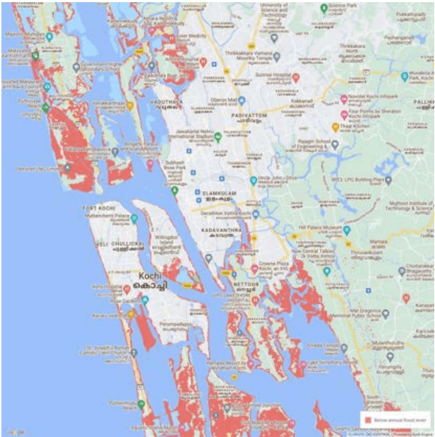
"Annual flood level" is used to denote the water level at the shoreline that local coastal floods exceed on average once per year. In other words, ten floods are statistically expected to exceed this level over ten years, although some years might have two or more incidents, and other years none. Below is the areas that expected to be below annual flood level in the year 2050 as per the screening tool developed by Climate Central, USA. Areas lower than the selected water level and with an unobstructed path to the ocean are shaded red. The
Kochi Municipal Corporation
DISASTER MANAGEMENT
maps are based on global-scale datasets for elevation and tides in addition to sea level rise projections.
Figure 22:5 Land projected to be below annual flood level in 2050
Disaster risks in Kochi
The geographical location and urbanization have made Kochi one of the most disaster prone areas. The major risks involved are,
• Geological;
• Water and Climate related
• Chemical and Industry related
• Biological
• Accident related
Kochi Municipal Corporation
DISASTER MANAGEMENT
Table 221 Hazard Seasonality mapping of the district
Disaster
Jan
Feb
Mar
Apr
May
Jun
Jul
Aug
Sept
Ooct
Nov
Dec
Earthquake
Drought
Wildfire
Lightning
Flood
Cyclone
Coastal erosion and storm surges
Tsunami
Landslide
Epidemics
Road/waterrelated accidents
Source: District Disaster Management Plan, 2015 Ernakulam and KSDMA data
The monsoon season ticks majority of the disaster risk categories with likely occurrence of disasters like flood, landslides , viral infections and mosquito related diseases, coastal erosion and storm surges. The storm surge also occurs during the November to December with occurrence of more high tides. Summer season also holds a break out water related diseases like jaundice, typhoid etc. Occurrence of earthquake and tsunami is majorly geological related and is expected at any time of the year.
Vulnerability of Kochi
The terrain of Kochi within the coastal wetland zone is highly fragile. Indiscriminate reclamation is permanently damaging the eco system. Cyclones and local severe storms have occurred in Kochi at 5 to 6 times during the last 100 years. Coastal erosion and storm surges are constant phenomena in Kochi. Flooding and water logging is another calamity occurring every year during monsoon, disrupting the activities of the region. The recent Flood in 2018 affected the coastal areas of Kochi resulting in losses of life and belongings. The location of the major chemical industries and petroleum installations pose serious threats of disaster occurrence like oil spills into the ocean and disasters related to leakage of gases which could be spread to the major city area with the westerlies. The very common biological threat includes mosquito vector diseases occurring with the rain showers. Apart from this the recent advent of CORONA virus disease has shook the world being classified as a global pandemic. Proper hazard management programme relating to all the vulnerable conditions is essential in city development.
Kochi Municipal Corporation
DISASTER MANAGEMENT
Kochi city is specifically vulnerable to the changing climatic dynamics owing to its location along the sea coast and steep gradient along the western slopes of the Western Ghats. High population density in coastal areas adds to the vulnerability. Therefore, as a consequence of global warming and climate change, sea level rise poses a very major threat.
Table 222 Damages caused in past years due to Disasters
Type of Disaster
Year
No. of Houses Damaged/ Individuals affected
Floods
2018
2315 Houses
Cyclone (Okhi)
2017
2648 evacuated
Others (Sea erosion, Wind, Rain)
2013
224 Houses
2014
347 Houses
2015
147 Houses
2016
197 Houses
2017
170 Houses
Source: Taluk office, Kochi and Kanayannur
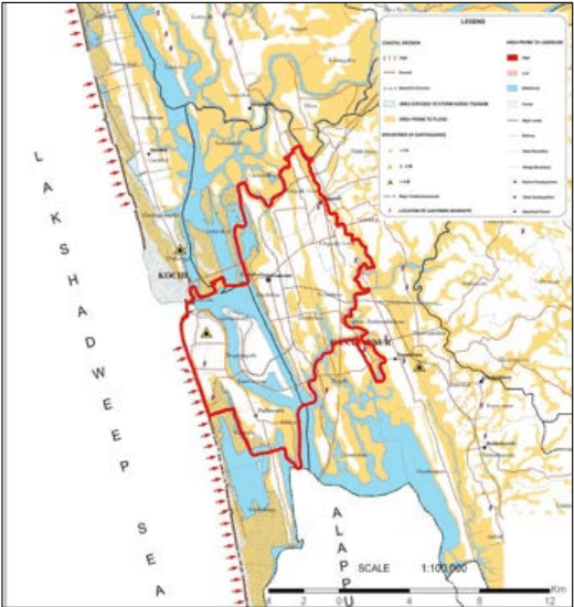
Figure 22:6 Multiple hazard zonation map
Source: Kochi Municipal Corporation website, prepared by KSDMA in 2009
Kochi Municipal Corporation
DISASTER MANAGEMENT
22.4.4Tsunami
They are high waves occurring for longer period and associated with earthquakes of oceanic origin. The effect of Tsunami in Kochi was seen in the year 2004, characterised by waves of height greater than 2.8m in Kochi. The flooding was maximum in wide stretches along the coast of Puthuvypin. Less inundation was experienced near Kochi backwaters. As part of the Tsunami Rehabilitation programme in the district Kerala State Housing Board has been designated as nodal agency for the implementation of the Coastal Housing and Re-settlement Programmes (CHRP) which includes flat reconstruction and in situ houses to restore livelihood and ensure sustainability in Post Tsunami rehabilitation activities which is majorly focused in the Puthuvypin area. The disaster management plan 2015 includes a Tsunami Crisis Management Plan for the district which focuses on actions to be taken in the warning, alert, watch and threat passed stages of a Tsunami. SEOC and DEOC play a key role in all the four stages.
Kochi Municipal Corporation
DISASTER MANAGEMENT
22.4.5Cyclones
The district witnesses myriad of events of mild cyclone and associated destruction during June –August (Southwest monsoon) and September –November (North east monsoon). Intense cyclones have become more frequent over the North Indian Ocean, especially in Bay of Bengal region, posing a more serious threat to the vulnerable coastal population of the region, and rise in oceanic temperature has backed and stimulated this trend.
This causes frequent winds and heavy rain fall occurrence in the western coast as well. Recent cyclones like Ockhi in 2017, Megh in 2015 etc. had created havoc in the coastal regions of Kochi. The Ockhi cyclone affected the population of not more than 100 fishing villages in the two states of Kerala and Tamilnadu and a crop area of less than 14,000 hectares. Rise in ocean temperature has led to increase in cyclogenesis rendering the occurrences to be unpredictable compared to the past. The coastal areas of Kochi are becoming more vulnerable as the industrial development and urbanisation progresses along the coast. Mangroves which act as natural and solid wall of protection against cyclones, storm surges and tsunami are become rare and is being confined into small pockets of neglect. Sea walls along the coast are also not a sustainable solution to beat the coastal calamities.
22.4.6Lightning
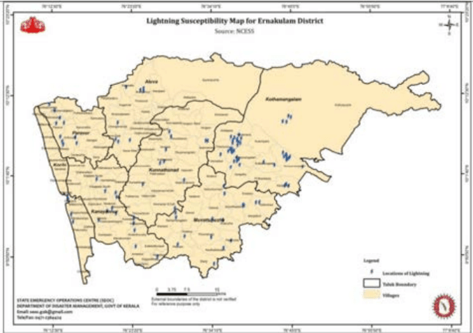
Occurrence of causalities during monsoon season is common within the district and therefore can be considered as thunder and lightning prone district of the state. The lightning phenomena majorly occur during the summer showers and the N-E monsoons. The lightning crisis management plan of the district as mentioned in the disaster management plan is distributed to four stages. ‘Normal’ stage where the preparation and updating of inventory occurs with participation from line departments. The second stage when ‘warning’ is received SEOC/IMD play major role. After the ‘emergency ‘stage with considerable impact, the agriculture department plays a key role in the recovery process. Palluruthy, Mattanchery, Puthuvype, central city area are prone to lightning
Kochi Municipal Corporation
DISASTER MANAGEMENT
Figure 22:12 Lightning susceptibility map for Ernakulam district Source: KSDMA
22.4.1Earthquake
Kerala has been placed in zone III, where the maximum expected intensity is 5.6 ML. Ernakulam district which falls under the low-lying terrain has high probability of occurrence of earthquake which is anticipated due to the rising building construction activities in the area.3 Kerala has experienced occasional mild tremors since historical times. However, pockets of higher ground acceleration have been identified in central Kerala. In this region higher levels of earthquake hazard are expected calling for the introduction of better building practices. In Kerala, several deep-seated faults exist, the notable among them are Periyar fault, Idamalayar fault, Muvattupuzha fault, Bhavali fault and Kuthuparamba fault. Besides there are many more minor faults and fractures that can generate minor tremors as a result of crustal readjustment.
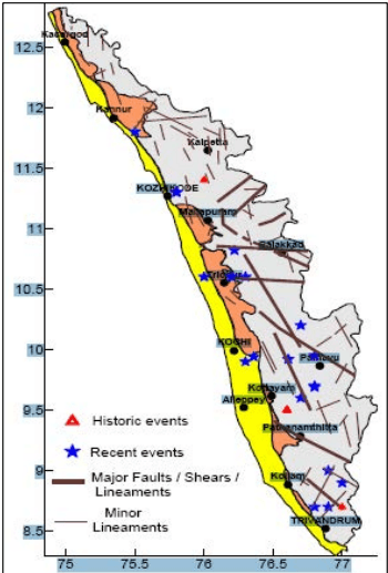
The locations of the earthquakes that have occurred in the Kerala region for which records are available are plotted in Figure 22:7 . Higher levels of seismicity are seen in Kottayam-Idukki districts and Thrissur-Palakkad districts. Detailed seismic micro-zonation of the urban areas especially those situated on reclaimed wetlands such as parts of Kochi city are still lacking. In Kochi amplification of seismic energy due to landfills and liquefaction of sub surface rocks are some of the major areas of concern. Kochi is located on a thick sedimentary pile consisting of alternating layers of sand and clay. Any seismic event can disturb these sediments.
Moderate earthquakes of Magnitude 6 are a possibility both on land as well as offshore sources.(Area falling within zone III of seismic zonation map) So far moderate earthquakes (M5) experienced in Kerala at distant sources( Erattupetta, Wadakkancherry sequence) from Kochi has not caused any damaging effects on these sedimentary piles. But in case such a seismic event takes place at or adjacent to this sedimentary pile (onshore or offshore) the effect is unpredictable. Such a calamity can seriously affect the foundation of multi-storeyed structures to cause its collapse. The clayey plastic soil of Kochi can be disastrous during tremors and the filling of water bodies and wetlands can amplify the disaster. Puthuvype and Mattancherry are hotspots of an earthquake occurrence within the corporation.
3 Disaster Management Plan Ernakulum district - KSDMA
Kochi Municipal Corporation
DISASTER MANAGEMENT
Figure 22:7 Location of historic and recent earthquakes in Kerala, Source: Kerala State Disaster Management Plan Profile
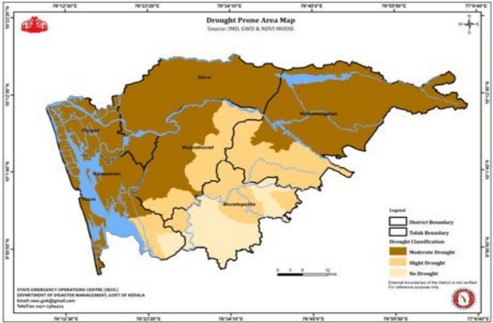
22.4.7Drought
The State of Kerala experiences seasonal drought like conditions every year during the summer months (KSCSTE, 2007). Even in the years of normal rainfall, summer water scarcity problems are severe in the midland and highland regions. In the period 1881 to 2000, Kerala experienced 66 drought years. It is noticed that aridity index of different parts of the state has increased which is an indication of increase in the frequency of drought years. The changes in the land and water management practices affected the fresh water availability during summer months. Although the deviation in the annual rainfall received in Kerala, in any year from the long term average is very small, there is considerable variation in the rainfall availability during the different seasons.
4 Draught situation assessment report , 2016
Kochi Municipal Corporation
DISASTER MANAGEMENT
Figure 22:13 Drought Prone area Map for Ernakulam Source: KSDMA
As per the map the region of Cochin Corporation can be seen falling under the category which experiences moderate drought. In 2017 Kochi faced a draught like condition which was followed by torrential rain 2018 and 2019. As the rainfall pattern has become more unpredictable and the unprecedented use of ground water has increased over time, Kochi now faces the major threat of depletion in potable water. In coastal stretches there is limited top sand layer and at places its hydraulic continuity with tidal backwater renders it saline during summer months. Although city receives rainfall of 3233 mm GW recharge does not happen much due to diversion into canals and sea without much permeation due to urbanisation.
22.4.8Biological
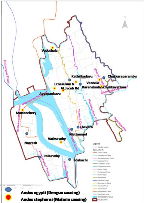
The biological issues are concerned with mass food poisoning, mosquito vector diseases etc. Among this the food poisoning generally happens due to human negligence. Health care in Kochi City is rendered through a network of hospitals and dispensaries run by the government and private organizations, with a large contingent of private practitioners. There is no record of indigenous transmission of malaria. But there are cases of malaria, imported from elsewhere.
Kochi Municipal Corporation
DISASTER MANAGEMENT
The occurrence of Aedesaegypti the vector of dengue has also been reported in these areas. Many areas are perennially water logged and thereby prone to mosquito genic conditions. The magnitude of the mosquito menace of Kochi has drawn the attention of health planners as well as the common man. Despite the will and efforts of all concerned, the problem still continues unabated. All activities pertaining to health services for the people of Kochi are under the charge of the Corporation Health Officer (CHO), who is also responsible for mosquito control activities. Profused breeding of mosquitoes in drains and canals is due to stagnation of water at various points and also faulty gradient. Further, accumulation of silt and garbage invariably blocks the drains. Extreme and scattered rainfall events which are common now lead to outbreaks of vector diseases.
Figure 22:14 Spread of Mosquito vectors in Kochi Source: Socio Economic survey -2019
Kochi Municipal Corporation
DISASTER MANAGEMENT
22.4.8.1 COVID-19
The district disaster management plan 2015 for Ernakulam has not considered the probability of an epidemic outbreak and the possibilities of containment as the occurrence of a global pandemic of biblical proportion is a new occurrence. The global pandemic COVID19 has led to death, devastation, migration and economic slowdown throughout the world. The first case in Kerala was reported in January 3 0 t h 2 0 2 0 and ever since the wave has been going up and down while being declared a state specific disaster demanding isolation and containment. The future possibilities of such outbreaks is high and therefore adopting early planning measures to arrest the outbreak and defining of containment zones needs to be considered.
22.4.9Chemical, industrial and fire related
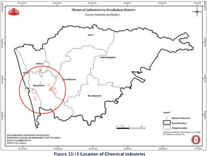
Industrial pollution due to effluents / waste discharge, accidents, gas leak etc., Oil spills, pesticide contamination of air water land etc. are common in almost all fast developing urban areas. The Kochi area with its fast developing industrial infrastructure is not any exception. The lack of proper facilities for waste disposal, waste treatment, sewage disposal, lack of alertness in treating industrial effluents before their ultimate disposal to the soil or nearby water bodies etc. cause severe pollution of air water and land. Compared to other cities in the State the level of vulnerability of Kochi City is high due to it being a prime harbour city handling huge quantities of chemicals, oil and gas for consumption in the country.
The major industrial firms in the district are the Fertilizers and Chemicals Travancore, Indian Rare Earths, Hindustan Machine Tools, Apollo Tyres, Hindustan Insecticides, Forest Industries of Travancore, Travancore Cochin Chemicals, Cominco Binani Zinc, Cochin Shipyard, Cochin Refineries, The Brahmapuram Diesel plant and Pathalam Naphtha plant are in the District. Approximately 29,037 small scale industrial units are functioning in this district. So there is a wide possibility of occurrence of chemical disasters. At present, no information on chemical and industrial risk reduction is available for the state. Individual industrial complexes such as the Kochi Refineries Limited have their own off-Site and on-Site DM Plans. However, considering the fact that hazardous chemicals are transported across the state by road, there is a need to address the transportation of hazardous substances under prevention and management of chemical accidents by respective ministries / State Departments in fine tuning the present legislative framework by introducing fresh rules, guidelines and facilities for the prevention and management of transportation emergencies. Although reasons for urban fire outbreaks are known, there is hardly any hazard or vulnerability assessment carried out in this regards and hence specific risk reduction strategies are very less.
Kochi Municipal Corporation
DISASTER MANAGEMENT
Figure 22:15 Location of Chemical industries Source: KSDMA
Westerlies carry pollutants towards eastern direction and Easterlies which are which are weak or absent during night accumulates pollutants at the source. During SW monsoon the pollutants are removed with scrubbing effect. Obnoxious industries causing air pollution are not recommended in the western coastal area. However majority of the industries and industrial areas like LNG terminal are located along the coast which calls for a vulnerability assessment in terms of chemical disaster risk in Kochi. Landward flow of wind from the coastal area where the industries are located makes the region more vulnerable
Response measures
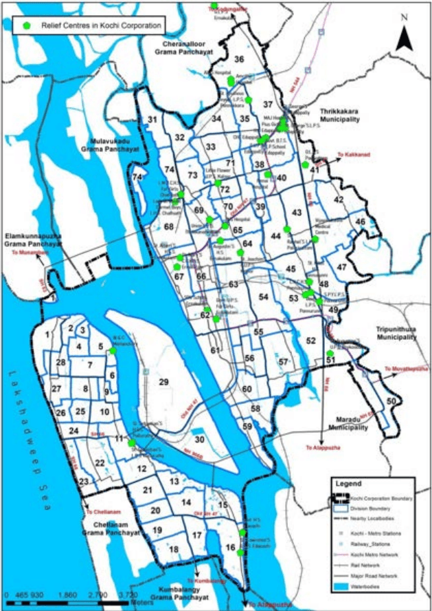
22.5.1Relief centres identified in Kochi and Kanayannur Taluk
KSDMA has identified relief centres in Kochi and Kanayannur Taluk and following are the locations within Kochi Corporation. Out of these while considering the return probability of flood as 1 in 50 years; AIMS hospital, C.K.C H.S. Ponnurunny, Sree Rudra Vilasom U.P.S. Ernakulam, SRV (D) L.P.S Ernakulam are found to be in areas likely to be flooded.
Kochi Municipal Corporation
DISASTER MANAGEMENT
Table 224 Relief centres in Kochi corporation
Sl no:
Relief centres in Kochi Corporation
Taluk
Return probability (1 in 50 Year)
1
W & C Mattanchery
Kochi
2
Govt. H.S. Edacochi
3
St. LawrenceS U.P.S. Edacochi</td><td></td></tr><tr><td>4</td><td>St. SebastianS H.S.S. Palluruthy
5
St. Sebastian`S. L.P.S. Palluruthy
6
AIMS Hospital
Kanayannur
7
Amritha Hospital
8
CHC Edappally
9
Gitanjali Hospital
10
MAJ Hospital
11
Pauls Kaloor
12
PVS Hospital
13
Renai Hospital
14
Shanti Hospital
15
Vijayalakshmi Medical Centre
16
C.K.C H.S. Ponnurunny
17
G.B.T.S L.P.S Edappally
18
G.L.P.S Ernakulam
19
G.L.P.S Padivattom
20
G.U.P.S Edappally
21
Govt. B.T.S. L.P.School Edappally
22
Govt. L.P.S. Ponnurunni
23
Govt. St. George L.P.S. Thiruvankulam
24
Govt. U.P.S. Edappally
25
Govt. U.P.S. For Girls Ernakulam
26
L.M.C.C.H.S. For Girls Chathiath
27
Lady Of Mount Carmel Boys L.P.S. Chathiath
Kochi Municipal Corporation
DISASTER MANAGEMENT
28
Little Flower U.P.S. Kaloor
29
Pius Girls H.S Edappally
30
S.P.Y.L.P.S. Ponnurunni
31
Sree Rudra Vilasom U.P.S. Ernakulam
32
SRV (D) L.P.S Ernakulam
33
SRV (D) U.P.S Ernakulam
34
St. AlbertS H.S.S. Ernakulam</td><td></td></tr><tr><td>35</td><td>St. AugustinS H.S. Ernakulam
36
St. AugustineS L.P.S. Ernakulam</td><td></td></tr><tr><td>37</td><td>St. AugustineS U.P.S. Thykoodam
38
St. GeorgeS H.S Edappally</td><td></td></tr><tr><td>39</td><td>St. GeorgeS.L.P.S. Edappally
40
St. Ignatious Leyola. L.P.S. Ponel
41
St. Joachim'S G.U.P.S. Kaloor
42
St. MaryS C.G.H.S.S. Ernakulam</td><td></td></tr><tr><td>43</td><td>St. MaryS C.G.L.P.S. Ernakulam
44
St. Raphel`S L.P.S. Palarivattom
45
St. Ritas H.S. Ponnurunny
46
Union L.P.S. Thrikkanarvattom
Source: KSDMA
Kochi Municipal Corporation
DISASTER MANAGEMENT
Figure 22:16 Location of disaster relief centres in Kochi corporation Source: KSDMA
Health & Family Welfare: Chemical, biological, radiological & nuclear disasters Factories & Boilers Dept., Dept. of Industries and the industry: Industrial accidents
• Agriculture: Pest attacks
Animal Husbandry: Cattle epidemics
Water resources: Dam break
Public Works: Building collapse
Forests: Forest Fire
• Airport: Air accidents
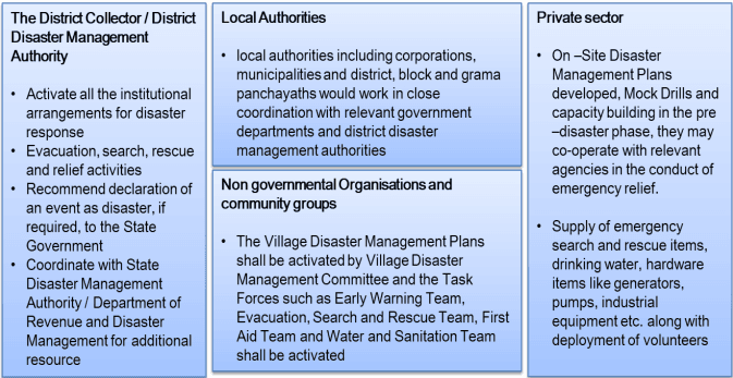
The disaster response phase involves emergency relief measures taken in anticipation of, during and immediately in the aftermath of a disaster event to ensure that the effects of the disaster are minimized. The stakeholders involved are as following:
Figure 22:17 Location of Chemical industries
The key activities in the disaster response phase is activating The Incidence Command System for the district which is an organized system of government departments and other agencies that are to be worked under a structured pattern for response and recovery with other bodies into ‘Emergency Support Functions’ like Communication, Search and Rescue, Law and Order, Emergency medical Care, Public Works (debris / road clearance, equipment support), Logistics (Water, Electricity and Transportation) and Coordination (warning, evacuation, relief, shelter, damage assessment, NGO / volunteers Coordination, Public Information / Help lines) as per their nature and type of assistance they
Kochi Municipal Corporation
DISASTER MANAGEMENT
can provide in a crisis situation. The State and District Emergency Operation Centres would facilitate the State Disaster Management Authority / Department of Revenue and Disaster Management and District Disaster Management Authority / District Collectors in Coordination, Operation Management, Information Collection and Documentation, Public Information and Resource Management in this phase.
For the evacuation search and rescue the District Collector guided by relevant Disaster Management Plans and supported by government departments particularly Police and Fire and Rescue Services, Department of Health, local authorities and Community Task Forces, would be responsible for evacuation, search and rescue. The relevant government departments should give priority to ensure sufficient food and water supply, sanitation mechanisms and temporary shelters to the affected population. The multipurpose community centres shall be converted to temporary shelters to accommodate the displaced population. Next, the district administration and local authorities would work in close coordination with relevant Government departments to restore the basic infrastructure and essential services to normal operating condition. It is necessary that law and order is maintained properly and security to the affected population and aid workers is provided to ensure uninterrupted relief operations. The immediate relief packages should be need based and customized to the specifics of the disaster and affected community and adhered to the minimum standards set for relief distribution. The state government shall explore additional sources of funding from central government agencies, if budgetary allocations of the state government for relief activities and funds available under Calamity Relief Fund and National Calamity Contingency Fund are inadequate to meet the requirements. In order to ensure optimum utilization of limited resources in the most efficient manner and to avoid duplication and over stretching, preliminary assessments should be carried out by the government departments and local authorities. All of this is shortly followed by Reconstruction, Rehabilitation &Recovery measures.
The disaster management plan of Ernakulam district 2015 lacks a futuristic framework which is a dire need in the wake of several extreme rainfall and flood events that has happened in city recently. The plan also needs updation in terms of measures to be taken in case of a pandemic spread. Overall the city needs to be ready for all types of disaster events Kochi have come out to be one of the most vulnerable cities in the world in terms of disaster events in the wake of climate change.
22.4.2Coastal erosion and storm surges
A detailed examination of the present erosion / accretion status of Kerala coast by the NCESS (Centre for Earth Science Studies) indicate that the coastal sites can be classified into low, medium and high erosion / accretion zones. The Coastal Climate is influenced by S-W and N-E monsoons. Strong S-W monsoon winds, with speed sometimes exceeding 60 km/hr blow over the coast during June to September. The waves are also highest during this period. The wave climate is governed by the south west monsoon when wave action can be strong with prevailing wave directions from north-west to south-west. Deep water (15m) wave observations in the past indicate the significant wave heights of 4m, 2m, and 1 m at the water depths of 10m, 5m and 2m respectively, the predominant wave direction being west. During the fair weather period of November-May the wave height is far below 1 m. The wave energy is not uniformly distributed along the coast and shows a general reduction towards the North. Corresponding to the wave climate, the long shore currents are stronger during S-W monsoon with a general southerly wind. During the other seasons the directions are governed by local conditions.
Kochi Municipal Corporation
DISASTER MANAGEMENT
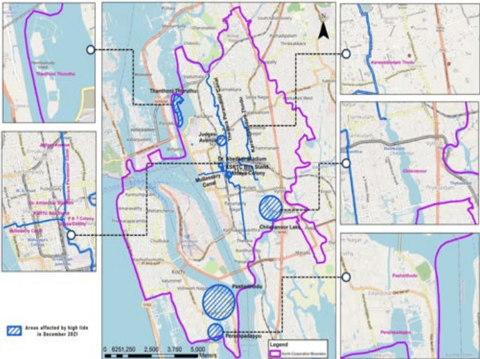
The tide is diurnal with a maximum range of 90 cm at Kochi. Maximum recorded high tide value is +0.44m and the maximum recorded low tide value is +0.158m with respect to Indian mean sea level. The tidal range decreases or increases towards the south and north respectively. The coastal area adjoining the Kochi Corporation is categorized by scientists as medium accretion sites. However, unusual monsoonal conditions can disturb the situation. The presence of harbour further assures proper maintenance of this zone. Further, the Vembanad estuarine wetland acts as a buffer to protect this coast line. As such the vulnerability to coastal erosion for the area within Kochi City is lower. The ‘Virschika veliyettam’ (the highest tides during a year) occur during mid-December. The tides that has occurred in December 2021 has affected several low lying areas like KSRTC bus stand and Ambedkar stadium, P& T Colony, Udaya colony, Thanthoni thuruth, Kaloor Judges avenue , banks of Thevara Perandoor canal, Karanakodam thodu, TP Canal outflow area to the backwater ( clogged with silt), Chilavannoor lake bank, Mullaserry canal bank area, Palluruthy south etc. Unlike previous years, from primary studies it is understood that more time is taken for the water to recede back into the backwaters.
Figure 22:8 Areas affected by high tide in December 2021 Source: Primary survey, 2019
Kochi Municipal Corporation
DISASTER MANAGEMENT
Storm surges are slow flooding of coastal areas. This happens due to unusual wind patterns developing waves and forcing sea water to flood low lying coastal terrain. This is normally a localized phenomenon and not of major concern as a disaster threat for Kochi.
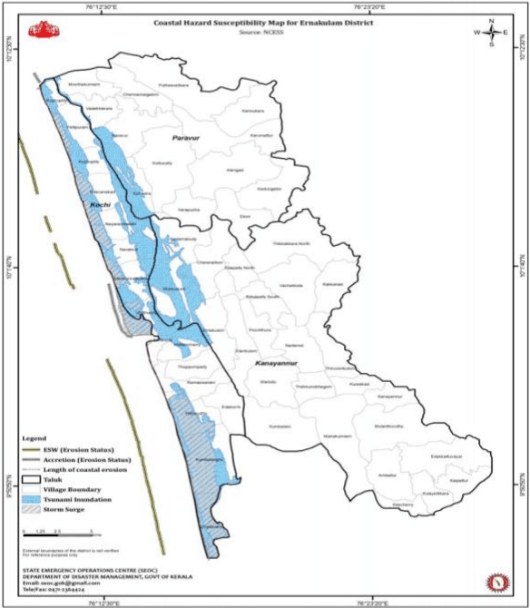
A coastal flood occurs in areas that lie on the coast of a sea, ocean or other large body of open water. It is typically the result of extreme tidal conditions. The direction of storm, wave height, velocity, onshore-offshore topography, size, speed and strength determines the severity of coastal flood. This phenomenon is observed in Fort Kochi to Mattanchery, Njarackal to Vypin near sea mouth, Willington Island and Bolghatty.
Figure 22:9 Coastal Hazard susceptibility map of Kochi, Source: KSDMA
Kochi Municipal Corporation
DISASTER MANAGEMENT
22.5.5‘Break the chain’, ‘Crush the curve’ Campaign for COVID-19 crisis
Break the chain was launched as campaign by Kerala Govt on March 15 2020 by health department through mass hand washing by installing hand wash kiosks, encouraging use of sanitisers, maintaining respiratory hygiene, wearing masks, social distancing, guidelines of movement, temperature checks and crowd control in public places in order to prevent the explosive outbreak of COVID-19 which is currently spreading in a rapid rate. With the participation of institutions, associations and groups in the state several kiosks all were placed all over Kerala. For the second wave of COVID-19, new strategies under ‘Crush the curve’ campaign were launched.
22.5.6 Orange book for disaster management
In the wake of the flood 2018 and Ockhi cyclone, As per section 22(2)(f) of Disaster Management act 2005 it was decided to develop a handbook for public in order to obtain all disaster related information , codes and details in order to brace better. A framework of incident response system integrating various departments comprises the core of the book. It has been revised after 2019 floods.
Kochi Municipal Corporation
DISASTER MANAGEMENT
22.5.7 Prathyuthanam
Scheme for the vulnerable families whose houses were damaged (15%-100%) during floods & landslides of July, August 2018. The financial aid is of Rs 25,000/- (Twenty Five Thousand Only) per family.
22.5.8 Ncrmp
The Government of India has initiated the National Cyclone Risk Mitigation Project (NCRMP) with a view to address cyclone risks in the country. NDMA is the implementing agency. Govt. of India has approved Phase II in July, 2015 for five years up to March, 2020 including Kerala.
Component A: Strengthening of existing Early Warning Dissemination System (EWDS)
Component B: Developing Cyclone Risk Mitigation Infrastructure like Construction of Multi-Purpose of Cyclone Shelter
• Component C: Capacity Building
• Component D:Project Management and Implementation Support
22.4.3Flooding
Kochi Corporation area lies in the low land area of the Ernakulam District. Flooding occurs due to filling up of stream or river up to banks and often spilling over the adjoining flood plains. In the case of Kochi, it may occur along the coastline and areas bounding backwaters due to various marine meteorological phenomenon other than riverine origin. Intense rainfall can be another cause for water logging and flooding in urban areas. The presence of blockages in urban tidal canals and infilling of flood plains in Kochi city can act as major causative factors in making the city vulnerable to Flood prone disasters. Kochi gets flooded during intense rainfall (KSDMP, 2016). Natural flood plains and levees act as buffers during flood. But the current pace of urban sprawl is encroaching the flood zone and flood fringe zone. 323.3 sqkm in the district is identified as flood plain. I.e. Almost 13% of land in the district lies in flood plain. The high rate of occupancy in areas close to flood plains, encroachment of banks, tidal canals and infilling of wetlands and paddy lands are detrimental to cause risk in terms of flood in the city.
During the last 25 years, the extreme rainfall incident was reported in 1991, when peak daily rainfall recorded was 236.8mm. Taking the case of District; it can be observed from the table that the highest rainfall recorded was at Perumbavoor during 1983, with rainfall for 1st, 2nd and 3rd days as 660, 780 and 1080mm respectively.
Table 223 Taluk wise area susceptible and population exposed to floods in Ernakulam
Name of Taluk
Area Susceptible to flood (Sq. Km)
Population exposed
Average population exposed per Sq.Km
Rank
Kanayannur
167.2
601323
3596
4
Kunnathunadu
164.48
179650
1092
3
Kochi
88.14
88308
1002
2
Paravoor
130
55215
425
1
Source: Disaster management plan for Ernakulam District, 2015
In Kochi Taluk, flood affected villages are chellanam, Kumbalangi, Palluruthy, Edakochi, Rameswaram, Thoppumpady, Mattanchery, Fort Kochi, Puthuvype, Elamkunnapuzha and Njarakkal. In Kanayannur Taluk areas like Edapally South, Edapally North, Ponnithura, and Elamkulam which falls within Corporation boundary are areas susceptible to flood.
Kochi Municipal Corporation
DISASTER MANAGEMENT
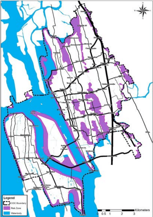
Figure 22:10 Flood risk area within Kochi Corporation based on climate change scenario for a period of next 50 years Source: KSDMA 2023
Kochi Municipal Corporation
DISASTER MANAGEMENT
Within the corporation area, water gets logged due to flatness of terrain. In these areas with impervious clay layer, the depth of inundation is directly proportional to the intensity of rainfall. In case of islands present within the corporation area; there is no source for flood other than precipitation. Water gets logged in depressions and areas where there are no drains or where there is waterlogging due to blockage of the drains. The other reasons can be attributed to inadequate size of drains and unnecessary meandering of drains in low-lying area. Dumping of solid waste and infestation of water hyacinth is worsening the scenario. Other contributing factors include encroachment by slums, silting of channels, and insufficient vent way in culverts, overloading of drains and canals and filling up of flood plains by construction activities. Also, wetlands which provide regulatory services in terms of controlling flood are also prone to degradation.
22.4.3.1 Flood -2018
Cause factors:
47% excess rainfall
• over flowing rivers& canals
poor drainage
Ernakulam district receives an average annual rainfall of 3289 mm. As per IMD data, the district received 2477.8 mm of rainfall from 1 June 2018 to 19 August 2018 n contrast to an expected 1680.4 mm of rainfall. This was 47% excess to the normal. The rains and subsequent overflow of Periyar, whose major portion in the district caused severe flooding and a significant damage to the inhabitants, existing built fabric and infrastructure of the city. Amid fears of the water from the Idukki dam spilling over, shutters were opened on the morning of August 10, increasing the flow of the Periyar River by 125,000 litres per second. The river being in full spate along with heavy downpours and rising water levels led to the flooding of Ernakulam district in 2018.
Out of the 14 urban local bodies, 13 local bodies were affected with flooding except Koothattukulam. In total, 290 divisions of 495 divisions were flooded in the urban area. Also 79 GramaPanchayats out of 82 with a total of 923 wards were affected with flood. Kochi Corporation was also affected by flood. The situation was worse in the western part of Kochi city as many areas were flooded. The areas that have been hit include Koovappadam, Manthra, Thoppumpady, Karuvelippady, Nazreth, Mundemveli and Palluruthy. Major canals in the area, including Rameshwaram, Kalvathy and Boundary canals, were not desilted before the onset of the monsoon. The mouth of the canals, which opened to the backwaters, could not be desilted. The accumulated silt prevented the rainwater from flowing into the backwaters. Around 1,500 families occupying Kammattipadam and P and T Colony in Gandhi Nagar
Kochi Municipal Corporation
DISASTER MANAGEMENT
division were hit by flooding. At Jose Junction, the flooding was caused by the block in the drains. Issues faced due to the flooding are discussed below:
1. Extent of Damages to Service Line and Utilities
Plenty of transformers were submerged and power was shut down due to inundation. Absence of power even affected cell phone towers and antennas
2. Loss of Critical Infrastructure
According to the Public Works Department (PWD), around ₹5.5 crore was estimated to repair damaged roads in Ernakulam division alone. 831 public buildings were affected by flood in rural areas where as 541 public buildings were affected in urban areas.
3. Problems in Identifying Safe Location of Rescue Shelters
Many of the rescue shelter started initial time of inundation were forced to shift due to rising water level. Also some of the relief camp opened were surrounded by water and were isolated.
4. Loss of Connectivity
22.4.3.2 Flood -2019
Cause factors:
Extreme rainfall event
Siltation of Urban drainage
Consequent to continuous rain exceeding 16 cm and inadequate urban drainage a flood occurred on 21stOctober 2019 affecting the functioning of main electric power station and vehicular movement through arterial roads and railway lines of the city creating an exceptional situation. The Ernakulam North, MG Road, Menaka, Ernakulam Junction etc were flooded. Within the Kanayannur Taluk areas that fall within the corporation boundary like Edapally North, Edapally South, Elamkulam and other areas like Cheranallur, Amballoor, Thrikkakara North, Vazhakkala, Nadama and within Kochi Taluk areas like Edavanakad, Njarakkal, Nayarambalam and Elamkunnapuzha was seriously affected leading to displacement of families. Following this urban flood mitigation project named ‘operation breakthrough’ for Kochi city was accorded as per the govt. order (Ms) no. 35/2019/DMD dated 11/11/2019 as decided in the executive committee meeting of SDMA.
22.4.3.3 Flood -2020
Cause factors:
Extreme rainfall
Poor maintenance and capacity urban drainage
• Tidal effects & sea storm
630
In extreme rain fall event that followed Panampillynagar, Stadium link road, Kaloor, MC road etc. were flooded within the city. Colonies like Udaya Colony, P&T colony, Mattancherry in West Kochi was affected by drains and sewers overflowing into houses and areas like Edapally-Aroor NH bypassin the east was also flooded. Other areas outside the Corporation boundary especially those along the banks of river Periyar and Muvattupuzha were threatened likeAluva,
Kochi Municipal Corporation
DISASTER MANAGEMENT
Pathalam, Kanakkankadavu , Kadungalloor, choornikara, karamaloor , Aalangad and Eloor. Several relief camps had to be set up amidst the COVID-19 crisis in Kochi, Kothamangalam and Paravur Taluk and the flood waters inundated several homes in Chellanam.
In Vypin east area, Najarackal Tidal effects had led to coastal flooding and in the Vypin west, Chellanam, Fort Kochi , Saudi, Manassery flooding was caused by the effects of Sea storm.
Based on the above the following functions can be undertaken in these zones: The safe zone can contain these functions that are imperative for rescue operations
• Hospitals,
Ambulance stations,
Police stations,
Fire stations,
• Transport facilities,
Communications facilities,
Community shelters and schools
The medium risk zone can contain
• Intermediate rescue camp and control station points.
• Flood resilient works along with green infrastructure to reduce flood
Improve the connectivity of green spaces
The high-risk zone can contain
Existing development in these areas must be prioritized for protection, retrofitting and preventive settlement.
• Low occupancy uses, including recreation, ecosystem-based livelihoods, eco-tourism.
22.5.3Operation Breakthrough for urban flood management
‘Operation breakthrough’ came about as result of the urban flash flood that shook the Kochi city in October 2019 affecting the functioning of electrical power station and vehicular movement through arterial roads and railway lines of the city. The district Disaster Management committee has been empowered to meet assess and accord administration sanction to the works proposed by the technical committee (comprising of 15 executive
Kochi Municipal Corporation
DISASTER MANAGEMENT
engineers with executive engineer, Minor irrigation as the chairman and executive engineer , Kochi Municipal corporation as the convenor. The field team is headed by AE and AEE who submits the estimates of One crore and below to DDMA and One crore and above to KSDMA which is examined by the Technical committee. The works undertaken (accorded with administration sanction) by various bodies like Kochi Corporation, GCDA, LSGD, Irrigation, PWD and IIP is mentioned in the Chapter 12 Drainage.
22.5.4 Rebuild Kerala
643
50 Crores were allotted from the state disaster relief fund to rebuild houses damaged in August 2018 floods in Ernakulam.
Table 225 : Status of Kochi and KanayannurTaluk in Rebuild Kerala Scheme
Kochi
Kanayannur
Paravur
Aluva
Kunnathunadu
Kothamangalam
Muvattupuzha
BENEFICIARY LED HOUSES
46
20
1265
164
64
48
16
CARE HOUSES
13
12
170
113
15
4
9
NGO HOUSES
2
9
47
17
1
12
3
Source: KSDMA
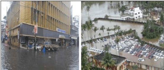
Bus services to Kochi were also affected after national highways connecting the city submerged in Kalamaserry area. Due to rise in water level at Bridge No. 176 on Down line between Angamali and Aluva, the services on this bridge were suspended from 15th August. The rail link between north and south Kerala was closed as railways suspended train traffic at Aluva and Angamaly stations over flooding. Later it was restored on 18th August. The Kochi Metro Rail Ltd has suspended its operations on 16th August after its yard in Muttom near Aluva submerged in the Kerala flood waters. The service was resumed once the water receded and the systems are back in good condition but was mainly for relief work. Kochi airport, among India’s busiest handling 1,460 flights every week, had been closed. Operations were suspended due to very high flood situation and key essential facilities like runway, taxiway, and navigation aids got submerged.
Kochi Municipal Corporation
DISASTER MANAGEMENT
Figure 22:11 Flooding in MG Road and Edapally
Source: Kerala Flood 2018 Documentation (Draft) Ernakulam District