Kochi is characterized by an almost flat topography and high water table. On an average, the eastern parts of the district are situated approximately 7.5 metres above mean sea level, while much of Corporation of Kochi lies between 1 - 2.5 metres above mean sea level. Further, the city has sand bars running from the north to the south, with several tidal canals in between. The climate in Kochi is tropical and the city enjoys monsoons twice a year, translating to annual rainfall of approximately 3,099 mm. The southwest monsoon, which usually lasts between June and September, brings around 60% of the annual precipitation, while the Northeast monsoon, which takes place between October and mid-November, typically brings about 25% of the annual rainfall in the region.
Drainage system
Cochin is dissected by numerous canals and backwaters which forms part of the Vembanad backwaters. Managing the quality and quantity of the waters in these tidal canals is of utmost importance so far as the quality of life is concerned. The drainage system in the area can be categorized into three levels as:
12.1.1 Primary canals:
These are major natural canals, which are running in north-south direction and a few natural canals that cut across the sand bars. The primary canals which convey the storm water runoff to the back water system which were once navigable are now highly degraded because of encroachments, waste dumping, silting, weed growth, low maintenance and lack of protective measures.
Table 121 Table showing the Primary Canals in Kochi Municipal Corporation Area
1. Thevara - Perandoor canal
2. Chilavannoor Lake
3. Changadampokkuthodu (Barge Way Canal)
4. Karanakkodamthodu
5. Edappally Canal
6. Mullassery canal
7. Chittoor puzha
8. Rameswaram canal
9. Punchathodu
10. Karee thodu:
11. Adimurythodu
12. Pashnithodu
13. Pallichalthodu
14. Thevara Canal
15. Market Canal
16. Muttar River
17. KannachanThodu
18. Poornipuzha
Kochi Municipal Corporation
DRAINAGE
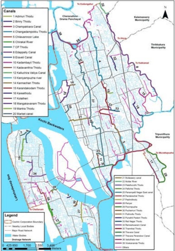
The important canals flowing in the corporation area are listed in the table above. Canals that are identified for the study are illustrated in figure 12-1.
Figure 12:1 Map showing major canals in Kochi Corporation area Source: Irrigation department, CoC 2020
Kochi Municipal Corporation
DRAINAGE
Thevara - Perandoor canal: Thevara – Perandoor canal also known as TP Canal is the primary drainage artery of Kochi Corporation. Having a length of about 9.95 km, it connects Perandoor on the north with Thevara in the south. It is a man-made canal that was once used for navigation, fishing, irrigation, recreation, flood alleviation and goods transportation. Kottayam-Ernakulam railway line has divided this canal into two. TP Canal runs through the centre of Kochi Corporation ie Panampilly Nagar, Kadavanthra, KSRTC, Kaloor and drains to Perandoor Kayal near Elamakkara/ Ponekkara. The catchment area of TP canal is about 30 sq. km and storm water/ Drainage water reaches TP Canal even from 1.5 km on both sides of the canal. The catchment area of TP canal is about 30% of the area of Kochi Corporation. Over the years, TP canal has become the repository of urban liquid and solid discharges. This canal has significant urban relevance in the present settings. Rejuvenation and committed maintenance of this canal could give a tremendous boost to the aesthetic appeal of the urban environment. .
Thevara - Perandoor Canal near Kaloor market
403
Changadampokkuthodu (Barge Way Canal): This canal links Kaloor with the Chittoor puzha/ Perandoor river. The Changadampokku Thodu and Karanakkodam thodu was originally connecting Perandoor puzha on the north and Chilavannoor kayal in the south and flows in between them. As the name indicates, this canal was developed for inland navigation. As the name implies, large wooden rafts or Changadams was plying through this canal for conveying materials from Perandoor river. However the connectivity of the two canals were lost in the developments that happened at Jawaharlal Nehru International Stadium near Kaloor. The water was used for fishing, washing, irrigation and bathing. Paddy fields flourished on either side of the canal. The canal tails out at the western boundary of the international stadium and south flowing Karanakkodom thodu begins where Changadompokkuthodu ends. Excessive waste load has ripped off the economic utility of the canal.
Kochi Municipal Corporation
DRAINAGE
Karanakkodamthodu: Karanakodam thodu is a part of Chilavannoor canal and it starts from the western side of JLN Metro station traversing towards south and ends at Elamkulam, where the water drains to Chilavannor kayal. Railway marshalling yard has altered the natural course of the canal. Once it was used for fishing, navigation, washing, bathing and irrigation. Earlier people depended this thodu to reach Edappally from Thripunithura and were used for the transportation of goods also. Now this thodu is seen separated into two at the Banerjee road near JLN metro Station. Now the thodu towards north is Changadampokku thodu and towards south is Karanakkodam thodu. Discharges from the sewage treatment plant have led to conspicuous eutrophication at Chettichira. Domestic and Municipal wastes are directly discharged into the water body. At the beginning of the canal, water is anoxic and stinking during dry spells whereas, down south water is comparatively better.
404
Mullassery canal: The Mullassery canal is a 1.4 km long waterbody passing through the prime commercial area of Kochi city in east – west direction. It begins from Perandoor Canal near KSRTC bus station and discharges into Kayal near children’s park at Marine Drive. Urban development has transgressed into the canal space in many parts along its length. Most of the portions of the canal are covered by concrete slabs and are being used as roadway, parking space, access to commercial establishments/ residences etc. Water is stagnant and anoxic. The canal begins at a low-lying area around Ernakulam South Railway Station and the natural gradient is not conducive to smooth flow of floodwaters. Water is turbid and coloured. Concrete slabs have been built on top of the canal at some places. The canal traverses towards west along Mullassery Canal road and afterwards crossing major roads such as Chittoor Road, MG Road, TD Road, Market Road and Park Avenue Road.
Mullassery Canal
Kochi Municipal Corporation
DRAINAGE
Chilavannoor Lake: Chilavannoor lake is a prominent water body located near Chilavannoor in the heart of Kochi City. It is the part of Vembanad back waters. The Rail Nagar thodu and Karanakkodam thodu discharges to the Chilavannoor lake. The Chilavannor lake extends from Subhash Chandra Bose road towards south upto Chilavannoor bridge on the tank bund road. The Chilavannor lake is heavily silted due to the lack of proper maintenance. Hence water carrying capacity of the lake has reduced.
Edappally thodu: This major canal connects the Muttar River on the northwest with the Chithrappuzha on the southeast. Edappally thodu forms the boundary of Cochin Corporation at the eastern side. Before urbanization reached the present levels, this canal was the chief commercial link of Edappally. It is the link between the two industrial hubs, Udyogamandal and Ambalamugal. It functioned as the boundary between erst while Travancore and Kochi kingdoms. The water was reportedly less turbid and was used for fishing, irrigation, recreation and navigation. At present NH-47 has cut the canal into two halves. The northern half is in a very bad shape by siltation, unwieldy outgrowth of weeds, clandestine solid waste disposal and neglect. The southern half is comparatively better off. Since agricultural activities have tapered off water is not any more used for irrigation. To the east of this canal the lateritic midland undulations become more pronounced. The alluvial bars and associated wetlands in between Edappallythodu and the backwaters are being subjected to anthropogenic modifications as part of accommodating the demands of urbanization.
Adimurythodu: It begins at Palarivattom and joins Karanakkodamthodu behind the International stadium. Domestic biological waste, mostly faecal contamination, has turned the water unhygienic. Water is anoxic at the confluence.
Punchathodu: This was developed as a natural drainage amidst the paddy fields (Punchappadam). The canal begins at Palarivattom and crosses NH Bypass north of Vyttila, flows south and joins Kaniyampuzha. The water was once used for irrigation, fishing and navigation.
Karee thodu: It runs parallel to Punchathodu and joins Kaniyampuzha. It evolved as a farmland drainage system. Once it was used for irrigation, fishing and small-scale navigation.
Poornipuzha: It is one of the arms of Champakkara canal stretching to Trippunithura and down south to Vembanad estuary. The canal crosses a flat wetland, where Andhakaranthodu joins it. It was used extensively for navigation and fishing. Now fishing continues to a limited extent. The water is saline for most part of the year. Municipal waste from Trippunithura municipality ends up here.
Kochi Municipal Corporation
DRAINAGE
Chittoor puzha/ Periyar river: It is a circular water body having direct link to the Periyar estuary and the Muttar River. Both Thevara-Perandoor canal and Changadompokkuthodu end up in Chittoor puzha which is a part of Periyar River. The constriction of Perandoor railway culvert obstructs smooth exchange of water between Thevara-Perandoor canal and Chittoor puzha. It receives a heavy dose of municipal waste from T P canal, Changadompokkuthodu and Aryanpadom thodu.
The north-western side of the canal merges with a branch of Periyar, which is part of the ammonia barge route to FACT, Udyogamandal. There are two freshwater courses ending up in this canal – Perandoor thodu and Changadompok thodu. Siltation and outgrowth of grass and aquatic weeds have thwarted the smooth flow of water further north..
Pashnithodu: It is a man-made canal built during the world war famine connecting Kaithappuzha kayal and Perumpadappu kayal. Water is turbid and unhealthy. Discharges from various fish processing industries make its waters unfit for any economic activity. Fish kills are regularly reported. However, fishing is going on at the kayal opening.
Pallichalthodu: It is a small canal running across Thoppumpady evening market to Kochi kayal: The water is ash-coloured anoxic slurry. It drains the market refuse and tidal action purges the canal to a certain degree.
Rameswaram canal: Remeswaram Canal represents the state of all the canals of Fort Cochin Mattanchery region. This is a man – made canal constructed by Portuguese for sailing boats. It starts from Vembanad lake near Cochin Fisheries Harbour at Karuvelippady and meets Vembanad lake where Periyar merges with the Arabian sea near Fort Kochi boat jetty. Rameswaram canal and its allied canal systems had been a hub of international trade in Kochi for centuries. Its present condition portents regular outbreaks of water borne epidemics. Navigation is possible in limited segments at the openings.
Rameswaram Canal
Kochi Municipal Corporation
DRAINAGE
Thevara Canal: Thevara Canal starts from Vembanadu kayal and ends at Chilavannur kayal. This kayal is having a length of 1.4 km and average width of 20 m. Koithara Canal, Konthuruthy canal and Thevara-Perandoor Canal are connected to Thevara Canal. The outflow from these canals reaches to the backwaters through Thevara canal.
Market Canal: Market canal starting from Ernakulam market at Bannerji road for a length of 730m discharges into the Kayal at the rainbow bridge having an average width of 9.60 m. History of Market canal starts at the era of “ The Maharaja of Cochin” about 150 years back who gave the Market area to Jewish traders for business. The northern end of Broadway, Basin Road and Jew street together forms the Ernakulam market with a row of temporary shacks come up on the side of Basin road with their back to the canal. Hence the canal also known as Basin Road Canal. Market canal used to be the lifeline of business in the market with the country boats bringing in goods until the 90’s as it is directly linked to the Vembanadu lake. As such the centre had trade connections from as far as Ponnani and Chavakkad in North and Kollam, Changanassery, Kottayam in south. The wide platform that protrudes the canal is the jetty where hundreds of large canoes carrying goods used to arrive from these places.
Muttar river: Muttar River is a major tributary of Periyar. The river is a major source of water for Aluva, Choornikkara, Kalamassery, Kadungaloor, Alangad, Cheranalloor, Varapuzha and parts of Kochi Corporation. Muttar river is currently under threat of pollution from nearby industries. It is the connecting link between Edappally canal and Periyar river
407
Kannachanthodu: Kannachan Thodu was one of the Hero distributary originating from Perandoor canal and driving down the shortest distance to reach Vembanadu kayal through Mangalavanam bird sanctuary near Terminus Railway station and High Court of Kerala. Many parts of the original Kannachanthodu is currently blocked thereby causing water logging in the surrounding areas.
It is found that almost all the tidal canals are in filthy condition. This is due to the dumping of wastes into the canals and lack of facilities for cleaning them due to inaccessibility of cleaning vehicles and machines. It is necessary that this canal and the shorelines are protected and maintained properly for better living conditions. Many of these canals were man-made when wetlands were reclaimed for paddy cultivation. Canals were developed to drain away excess water. This explains the genesis of canals like Punchathodu, Khari thodu, Karanakkodamthodu, Adimurythodu etc. Edappallythodu, TP Canal, Changadompokkuthodu, Pashnithodu etc were developed by man to facilitate navigation.
Kochi Municipal Corporation
DRAINAGE
12.2.1 Natural and manmade secondary drains:
Natural secondary drains are the feeder drains/canals of primary canal. The man-made secondary drain encompasses major roadside drains, which go beyond the level of area drains. They link with the Primary drains (tidal canals) running in north-south direction.
12.2.2Area Drains:
408
The area drains are the drains which discharge the storm water and sullage from a neighbourhood to secondary drain. The city has large network of area drains, which act as major storm water receivers. The area drains are absent in many of the areas especially in areas with urban proliferation. These drains need immediate attention. These are the primary cause for water logging in the various neighbourhoods in the city. In the traffic and transportation study conducted for the City Development plan reveals that 87.5% of the roads network had drainage facility. However, only 8% of these roads were having covered drainage.
Table 122 Table showing the length of drains in Kochi Corporation
Sl. No.
Description of item
Quantity (Km)
Kochi Corporation
1
Total length of the primary canal
77
2
Total length of the natural and manmade secondary drains
222
3
Total length of area drains
740
Source: Irrigation Division - Ernakulam, Kochi Municipal Corporation
Above mentioned eighteen major canals traverse through the Corporation area serving as primary or arterial drains. These canals discharge into the back waters. The secondary drains join the arterial canals that discharge the storm and sullage coming from tertiary drains of the Corporation area. The total length of secondary drains is approximately 222 km. At present, total length of area drains is 740 km within Corporation of Kochi.
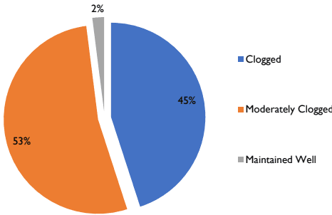
Actual Capacity of these drains cannot be calculated due to heavy silt deposition, discharge of solid wastes and growth of vegetation. Figure 12:2 shows the condition of the drains as given in City Sanitation Plan, 2011. As per the sample study of city sanitation plan, 2011, 45% of the drains are clogged and 53% of the drains are moderately clogged and the remaining of them is maintained well. 80% of the drains in the Corporation area are inadequate to carry the discharge during peak flow due to inadequate capacity in certain culverts and bottle necks.
Kochi Municipal Corporation
DRAINAGE
Also, missing links in the existing drainage networks, irregular/ inadequate maintenance of existing canals and storm water drains act as constraints leading to inefficiency of drains.
Figure 12:2 Condition of the drains
Source: City Sanitation Plan, 2011
After Operation Break Through (OBT), which was aimed at renovating and removing the blockage of the canal and backwater mouths, small canals etc, the conditions of drains have gradually improved. The project was implemented in two stages. In the first phase, the drains in the city were renovated to avoid flooding and in the second phase, the kayal mouths were concentrated to remove the obstruction. Now, the third phase of OBT is under way.
Backwaters and Water Bodies
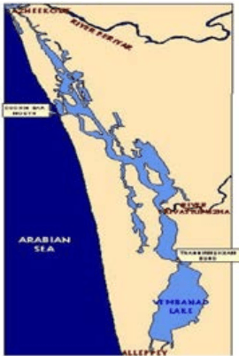
Drains and canal networks in Kochi are inextricably linked to the Vembanad Lake and backwaters, which form part of a long chain of lakes and canals with its northern boundary at Azheekodu and southern boundary at Thaneermukam bund (Figure 12:3). The total area of the Backwater is about 157sq.km (from Survey of India toposheet, 1981) with depth ranging from 2m to 8m. Two rivers, Periyar and Muvattupuzha discharge into these backwaters. Their ecological importance stems from the following:
➢ The salinity gradient in Kochi Backwaters supports diverse species of flora and fauna, according to their tolerance for saline environment.
➢ This tropical estuary, with high productivity acts as a nursery ground for species of marine estuarine fin-fishes
➢ The low-lying swamps and tidal creeks dominated by sparse patches of mangroves provide shelter to juveniles of many species.
➢ The areas of the backwaters with fine sediments and organic matter supports fauna.
➢ The changes in the hydrology of backwaters controlled by the seas play an important role in regulating the migrant fauna of the estuary.
Major threats to Kochi Backwaters and related concerns include massive reclamation for development, creation of hydraulic barrier bunds that impact natural flushing in the canal systems, and disposal, pollution due to coconut husk retting, industrial pollution from the Eloor - Kalamassery belt and over-exploitation of fish and other resources.
410
Storm water Drainage System
The city has a separate storm water drainage network but lacks a sewerage network. So grey water and black water is also discharged in to the canals and drains. According to census 2011, 87.41% of the Household wastewater outlets in the Corporation area are connected to storm
Kochi Municipal Corporation
DRAINAGE
drainage. The high water table, tidal effect and malfunctioning of septic tanks all aggravates the issues related to drainage.
Table 123 Household wastewater outlet connected to drainage
Indicator
Kochi Municipal Corporation
Kerala (State)
% of Household wastewater outlet connected to drainage
87.41
54.55
Source: Household amenities and assets, Census of India 2011
Major locations where the storm water mixes with sewer water includes Fort Kochi-Mattancherry, Thoppumpadi – Palluruthy – Edakochi, Vaduthala – Pachalam, Kaloor – Kathirikkadavu, Edappally – Palarivattom, Thammanam – Karanakodam, Padivattom, Pipeline – Vyttila, Vyttila – Petta, Vyttila – Vennala, Vyttila – Thykoodam and Thevara – Konthuruthy. The major reasons can be attributed to absence of sewerage system, inadequate capacity of septic tank and poor condition of septic tanks. Table 12:4 provides comparative information of service levels with respect to the service level bench marks prescribed by MoUD and sustainable standards for service levels under the National Mission on Sustainable Habitat (NMSH) for Corporation of Kochi. Coverage of storm water drainage network in the city is only 68% when compared to the sustainable standards.
Table 124 Status of Storm Water service levels
Indicators
Sustainable standard
Black (Caution for improvement)
Red (Immediate action for improvement)
Present Status
Coverage of Storm water drainage network
100%
<75%
<50%
68%
Incidence of sewerage mixing in the drains
0%
<25%
<50%
40%
Incidence of water logging
0%
<25%
<50%
62Nos
Source: CSP, CDP and municipal registers
Out of the total length of the drain length, 1400km of drains are required to be up graded and covered. 38km of the drains have been covered and upgraded in 2016-17. Incidents of water logging in the city, varies according to the tidal effect and rain during monsoon, which are unpredictable due to climate change.
12.5.1Operation Breakthrough
The project envisages clearing of obstacles in the drains, identifying the drains leading to major canals and also identifying the canals that need to be desilted. It was an urban flood mitigation measure. The District Disaster Management committee has been empowered by the government for the implementation of operation breakthrough as an immediate and emergency action.
The Project was implemented in two Phases. In the first phase, the drains in the city were renovated to avoid flooding. A total amount of Rs. 10 Crores was utilized for implementing Phase 1 works. Phase 2 works were mainly concentrated on clearing the Kayal mouths and obstructions in major canals in the city. The third phase of Operation Break Through is under way. The third phase mainly focusses on the deepening and widening of Mullassery Canal from TD Road to the bar mouth. Irrigation department is implementing the project in the city. The project is expected to resolve the flooding of KSRTC bus stand, railway station and MG Road as a result of the blocked canal.
12.4.1Topography
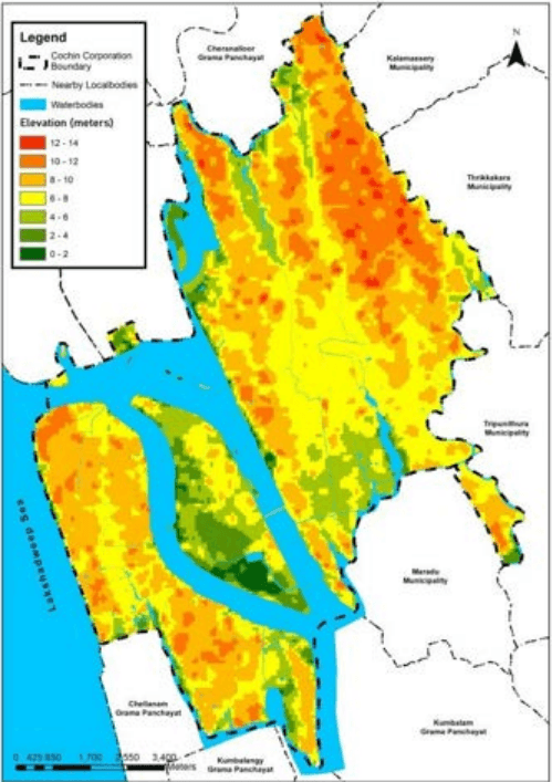
Being a coastal district majority of the city is within the low land regions of the district. The average altitude towards the eastern fringes is about 7.5 m above MSL, and towards the west
Kochi Municipal Corporation
DRAINAGE
the altitude is less than one meter on an average. The elevation map of Kochi Corporation area is shown in Figure 12:4.
Figure 12:4 Elevation Map of the Kochi City Source: Generated from DEM
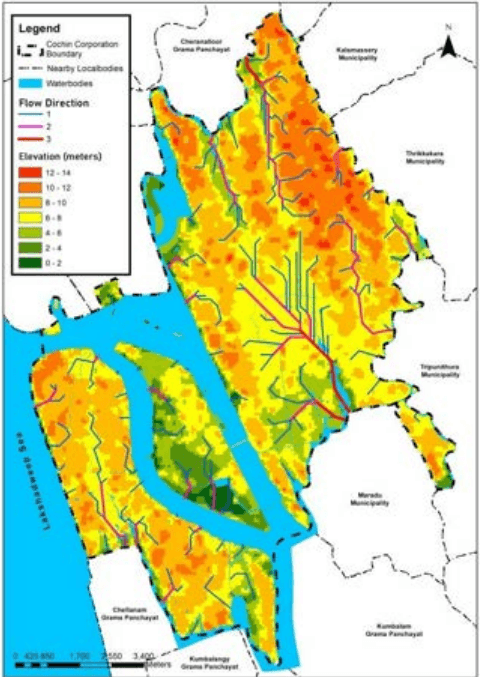
The whole of the land slopes gradually from east to west. Figure 12:5 shows the flow direction map prepared, based on the elevation map. It shows a lower elevation in the middle portion of the mainland creating a trough shape structure. Water from this area has to flow mainly
Kochi Municipal Corporation
DRAINAGE
through Thevara – Champakkara area to drain to backwaters which underlines the periodic canal deepening and desilting operations of these areas increasingly important. The flat terrain of the central city with the low altitude interspersed with a network of canal system provide link to the backwaters. The terrain features have also adverse influence on the sewerage and drainage system of the area. To ensure ruling gradient the drains have to be deepened often below the sea level and the sewage has to be regularly pumped to its outfall regions for disposal.
Figure 12:5 Flow analysis in Kochi Corporation area Source: generated from DEM
Kochi Municipal Corporation
DRAINAGE
Initiatives to Improve Drainage
12.5.2Integrated Urban Regeneration and Water Transport System Project (IURWTS) by KMRL
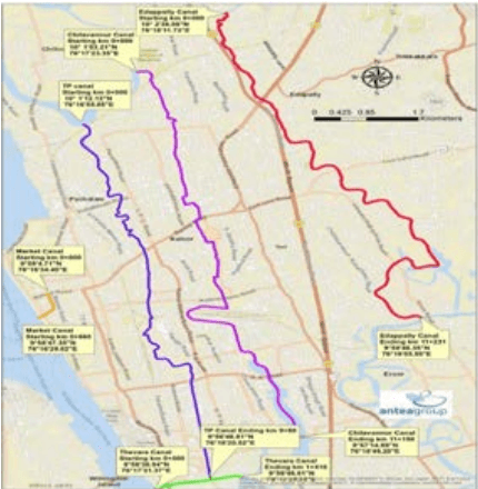
KMRL under IURWTS (Integrated Urban Regeneration and Water Transport System Project) has taken up the project of rejuvenating and renewing major canals in Kochi. It also aims to reclaim the canal edges as a public asset, improve its spatial structure and develop an inland navigation canal network that could promote tourism and other recreational purposes. The total length of the project is 34.98 km which includes Edappally Canal (11.23 km), Chilavannoor Canal (9.88 km), Perandoor Canal (11.15 km), Thevara Canal (1.41 km), Market Canal (0.66 km) and Konthuruthy Canal (0. 65 km).
The project consists of Canal development that includes canal cleaning, canal deepening and widening, canal shore protection and canal lock arrangements; Canal bank infrastructure development that includes reconstruction of roads along the canal, construction of jetties, construction of foot over bridges, landscaping and road bridges. It also includes other ancillary infrastructure development like Non – Motorized Transport, Navigational Aids, Sewage Treatment Plants and Solar installations.
Kochi Municipal Corporation
DRAINAGE
Figure 12:6 Canals included under IURWTS Source: KMRL
12.6 Issues
12.6.1Water Logging
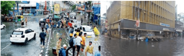
The city is facing severe water logging problems. A number of places in the city suffer from water logging due to heavy rainfall in the monsoon. During the period of water logging, normal life and traffic movements of the city gets disrupted. Water logging in some roads persists for few hours whereas that in certain lowlands continues for a few days. The problem of water logging is handled as a case by case process. Corporation maintains two mobile squads which respond to complaints of water logging; the squad inspects the location and clears the problem. In some locations, excavator machine and heavy truck is hired by the corporation and water logging is cleared by making channels from water logged areas to natural drains located in the area. These remedies are only temporary and do not provide a satisfactory outcome.
Kochi is embedded in a complex network of rivers, tidal creeks, backwaters, lakes and the sea which are vital to supporting the city’s coastal communities in addition to being effective channels that can drain off water in the event of extreme rainfall. Studies done by the Cochin University of Science and Technology found that canals that were once vital lifelines for the city have been reduced to stagnant, polluted pools, such as the Edappally thodu, Perandoor,
Kochi Municipal Corporation
DRAINAGE
Mullassery, Thevara canals. Building over these waterbodies has significantly reduced Kochi’s ability to cope with the monsoon
Photo showing Flooding along metro line and Marine drive, Kochi
12.6.3Decrease in the width of the canals
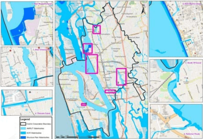
On comparing the existing width of the canals with the width of the canals in the earlier planning documents as well as the satellite images, it can be seen that the width of the canals have reduced considerably over the years thereby reducing the water carrying capacity. The reduction in width of the canals at five major points inside the Kochi Corporation near Goshree bidge, Chilavannoor canal, Thevara canal, Marine drive, North TP Canal and Pallichal Thodu is shown below.
Figure 12:7 Comparative study of the Width of canals in Kochi Corporation based on previous master plans
Source: Generated from google earth historic imagery, primary survey, structure plan for central area 2001, Draft master plan for KCR region 2031
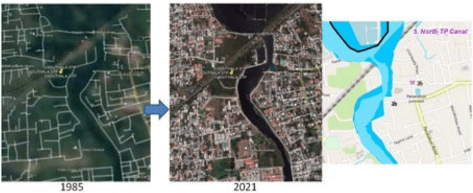
The comparison of North TP Canal is shown with satellite picture as an example in Fig. The comparative study of North TP Canal with reference to the previous planning documents and satellite picture is shown in Figure 12:8. The comparison clearly shows how the width of the canal has reduced considerably over the years thereby reducing the water carrying capacity.
417
Kochi Municipal Corporation
Figure 12:8 Comparative study of the width of North TP Canal
Source: generated from google earth historic imagery, primary survey, structure plan for central area 2001, Draft master plan for KCR region 2031
MASTER PLAN FOR KOCHI MUNICIPAL CORPORATION AREA -2040
DRAINAGE
12.6.2Land use changes
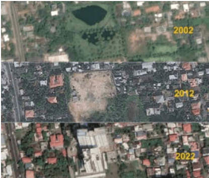
The land use changes that has resulted as result of rapid urbanisation has resulted in the loss of wetlands which would otherwise have acted as sponge spaces to absorb the excess runoff. Fig shows the satellite picture of a site in Kumaranashan Nagar, near Elamkulam taken during 2002, 2012 and 2022 over a course of 20 years. In the 2012 image a green space was clearly seen. By 2012 the greenery was lost and within the next 10 years a building has also come up. The same issue can be seen in the surrounding areas. The image shows how Kochi rapidly grew from 2002 to 2012 to 2022, with the built-up area gradually growing over the city’s various interconnected canals and water bodies.
Photo showing destruction of natural sponge spaces over a span of 20 years in Kumaranashan Nagar near Elamkulam, Kochi Source: Generated from google earth historic imagery
Kochi Municipal Corporation
DRAINAGE
12.6.4Issues in achieving service levels
Major challenges faced in the city with regards to achieving service levels are as follows:
The Tidal effect. If rain occurs during the high tide time intruding tidal water prevents the discharge of storm water from the main canals to the back waters.
Reduction of canal width due to road construction and encroachment, inadequate vents way of the bridges and culverts.
Unscientific gradient of the drain affects the free flow of storm water.
Poor condition of the existing canals resulting in over flow and flooding in adjoining area.
Obstruction by utility lines, such as water mains, power and communication network cables etc. crossing the canals, drains and culverts.
The railway line divides the city in vast areas, which is affecting the continuity of the drain.
Railway culverts are perennial bottlenecks both in height and width.
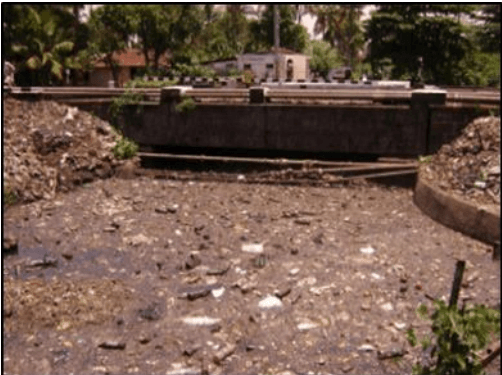
Waste dumping and sullage flows into the canal and drains are adding on to the ineffectiveness of the drain and are making them vulnerable pollution hotspots. Image shows the Mullassery canal filled with debris and solid wastes.
418
Lack of a city wide drainage and canal master plan, lack of integration and inadequate focus on design requirements further limit the functioning of the cities drain network.
Kochi Municipal Corporation
DRAINAGE
Mullassery canal filled with debris and Solid waste
Agencies Responsible
The Kochi Municipal Corporation (KMC), State Irrigation Department and Public Works Department are jointly responsible for operation and maintenance of the existing drainage system of the city. The type of drains and the agencies responsible for their O&M is tabulated in Table 12:5.
Table 125 Agencies Responsible for Drainage
Type of Drain/ Canal
Agency Responsible
Drains along internal roads
Kochi Municipal Corporation
Drains along the National Highways
PWD (National Highways)
Drains along State Highways, District Roads &anyother major roads
PWD (Road & Bridge)
Drainage Canal & other water bodies
State Irrigation Department
Source: TA 4106 –IND: Kerala Sustainable Urban Development Project Preparation, 2005
Kochi Municipal Corporation
DRAINAGE
Other stakeholders are the contractors who are given the task to clean drainages. One major issue they face is the transportation of the silt, as it is difficult to transport wet silt. This result in the accumulation of the debris collected adjacent to the drains, which may easily flow back to these if not transported. Unavailability of land for proper disposal of the silt collected is another problem that needs to be addressed.
The main sources of input to canals and drains are storm water and waste water. Ensuring the implementation of the rainwater harvesting system as mentioned in the Kerala Municipal Building Rules would help in reducing the amount of runoff that may result in floods. Urban planning measures such as identifying catchment areas and incorporating it into physical planning (e.g., creating recreational, multi-purpose spaces, etc.) at different levels should also be looked into.
420
12.6Inference
It is observed that even though the Corporation of Kochi is enriched with many canals and drains; the issue of Water logging pertains. Actual Capacity of the drains present in the City cannot be utilised to its potential due to heavy silt deposition, discharge of solid wastes, growth of vegetation, reduced width and interrupted connectivity of drains. Due to rapid urbanisation the natural green spaces in the city have also reduced considerably. There is a need for the natural drainage system to be recovered and conserved. The canal edges of water bodies also need to be protected to avoid encroachment. At present there is mixing of wastewater and storm water in these waterbodies thereby posing many major health risks. Thus the absence of a sewerage network triggers load on the existing drainage network along with narrow roads and drains. Therefore, a separate drainage has to be developed for wastewater disposal in the Corporation area with adequate treatment facilities before it is discharged to open source of water. The above factors make managing drainage a challenge in Kochi.