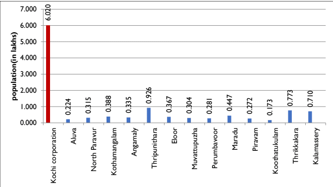
Kochi Municipal Corporation being the only first order settlement in the district is the most highly populated urban local body in the district as shown in the figure below. It has a geographical area of 94.88 Sq.km. Its population is more than 6 folds the highest populated Thripunitura and 35 times the least populated Koothattukulam among the other urban local bodies in the district. Figure 4-3 shows the comparison and Table 4-2 shows population of Kochi Corporation area and other urban local bodies in Eranakulam District
Figure 4:3 Comparison of the population of Kochi Municipal Corporation with other Urban Local Bodies in the district Source: Census 2011
Table 42 Population of Kochi corporation area and other urban local bodies in Ernakulam District
LSG's
2001
2011
Kochi corporation
595575
602046
Aluva
24110
22428
North Paravur
30059
31503
Kothamangalam
37173
38837
Kochi Municipal Corporation
DEMOGRAPHY
Angamaly
33409
33465
Thripunithara
59884
92550
Eloor
35573
36722
Muvattupuzha
29246
30397
Perumbavoor
26547
28110
Maradu
41012
44704
Piravam
27263
27229
Koothatukulam
17253
17253
Thrikkakara
65984
77319
Kalamassery
63116
71038
Source: Census data
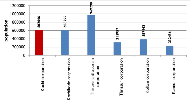
It is the third highly populated municipal corporation in the state after Thiruvananthapuram corporation (969298) and Kozhikode corporation (608255) as shown in figure below. Kannur being the recently formed municipal corporation has the least population among the municipal corporations.
Figure 4:4 Comparison of Population of Kochi with other municipal corporations in the state-2011 Source: Census -2011
Kochi Municipal Corporation
DEMOGRAPHY
Chapter 4Demography
47
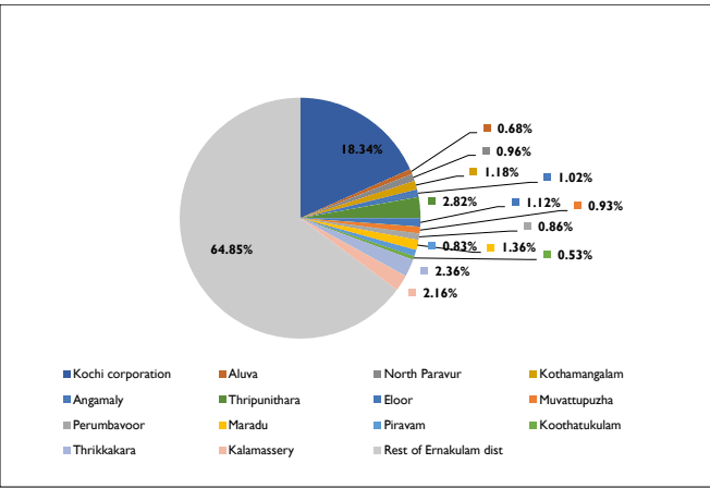
The Demographic parameters help in understanding the pattern of population within a city. This chapter gives a brief account on the Population size, Population density and other demographic aspects.Ernakulam district has the credit of being the economic nerve centre of the state. It is the industrially advanced and flourishing district of Kerala. According to 2011 Census, Ernakulam district has a population of 3,282,388 persons with an average density of 1,072 persons per sq. km. Out of the total Ernakulam population as per 2011 census, 35.15% lives in urban regions of district. Figure below shows percentage share of population in Kochi and other urban local bodies, Ernakulam district.
Figure 4:1 Percentage share of population in Kochi and other urban local bodies, Ernakulam district. Source : Census 2011
As per census 2011, the population of Kochi Municipal Corporation is 602046 which amounts to 18.34% of the total population in the district. Area wise, Kochi Corporatiom amounts to just over 3% of the total area of the district. When compared to the other urban local bodies
Kochi Municipal Corporation
DEMOGRAPHY
in the district, Kochi has the highest share of urban population in the District, even higher than the total share of population of other urban local bodies in the district. Percentage share of population of Kochi Municipal Corporation and that of Eranakulam District is shown in figure 4.2.
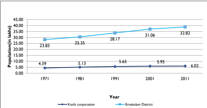
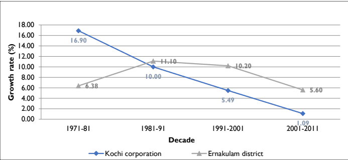
The municipal population is also growing in a very slow pace. It is evident that the growth within the municipal limits is witnessing saturation .The variation of the population from 1971 onwards, in comparison with the District is shown in figure below.The population for Kochi Municipal Corporation had increased from 4.39 lakh in 1971 to 5.95 lakh in 2001 and eventually reached 6.02 lakh in 2011. Table 4-1 shows population growth trend of Eranakulam District and Kochi Municipal Corporation.
Figure 4:2 Temporal variation of population of Kochi and Ernakulam district 1971-2011 Source: Census data
Table 41 Population growth trend of Ernakulam District and Kochi Corporation (1971-2011)
Name / Year
Population per year
1971
1981
1991
2001
2011
Kochi corporation
439066
513249
564589
595575
6,02,046
Ernakulam District
2383178
2535294
28,17,236
31,05,798
32,82,388
Source: Census data
Kochi Municipal Corporation
DEMOGRAPHY
Population Growth Rate
Kerala started showing a constant decline in population growth rate since 1981 census. The net addition to the population has also been continuously less ever since. The population growth rate of the state in the last decade (2001-2011) is 4.86, less than the growth rate of 1991-2001. The growth of population during 2001-2011 has declined in all the districts of the State including Ernakulam, when compared to the growth rate in 1991-2001. Even so, Ernakulam district is among those districts having population growth rate of 5.69, higher than the State average during 2001-2011, together with Kasaragod, Malappuram, Palakkad and Kozhikode, all of which fall in the middle and North Kerala. (Source: Census 2011).
In the recent years due to many large scale development projects, especially in the construction sector and information technology, substantial employment opportunities are generated in Kochi and this is a positive factor for migration. However, sharp increase in land values and scarcity of developable land prevent lower and middle income group families from buying land within the city for residential purposes. This has made a good percentage of people to opt for residences in the outskirts of the city. Though the trend reduces migration, it increases floating population in the city.
The contributing factors of population growth in the area are mainly the natural increase and the migration from nearby rural areas for trade and employment. Even though the natural growth rate of population does not show exorbitant increase, floating population and migration in Kochi are to be considered while proposing infrastructure requirements. Facility for daily commutation from the region around adds to the increased number of floating population in the city.
Population growth from 1971 to 2001 shows a gradual decreasing trend in the corporation in tune with the Urban Local bodies. Declassification of some of the urban settlements of 1991 and the resultant reduction in urban areas is a major factor leading to this situation. This is a pattern of urban growth contrary to the popular belief that there is in migration of people into the urban area. Table 4.6 shows the temporal variation of decadal population growth rates of Kochi Municipal Corporation with that of Ernakulam district.
The comparison of decadal growth rate with other local bodies in the district is shown in Figure 4-7. The growth rate of Kochi Municipal Corporation decreased from 10% in 1981-91 to 1.09% in 2001-11. The present decadal population growth rate of Kochi city is 1.09 %, which is very low when compared to the decadal growth rate of the district and state being 5.6% and 4.87%.
Kochi Municipal Corporation
DEMOGRAPHY
Figure 4:5 Temporal variation of Decadal population growth rates of Kochi Municipal Corporation and Ernakulam District 1971-2011 Source: Census -2011
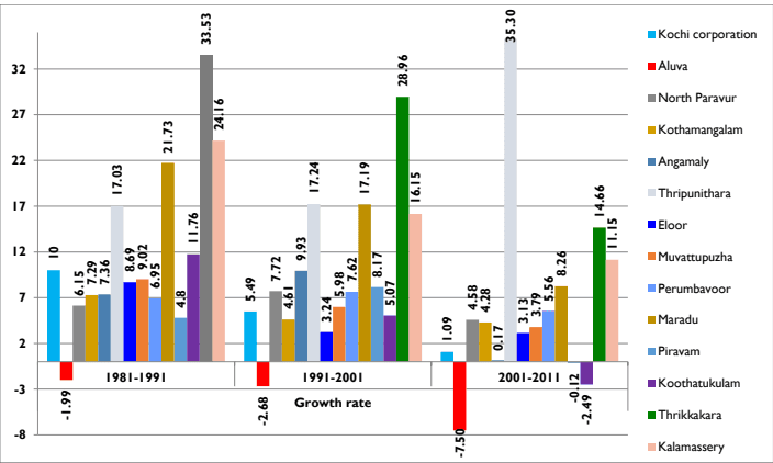
When compared to the other urban local bodies in the district, Kochi has a very low decadal population growth rate. Neighbouring towns like Thripunithura, Thrikkakkara and Kalamassery are the fastest growing urban local bodies in terms of population with growth rates of 54.55%, 17.18% and 12.55%.The high growth rate of Thripunitura is associated with the change in its administrative area after adding Thiruvamkulam to it. However the growth rates of all these urban local bodies show a declining trend with Aluva, Piravom and Koothattukulam showing negative growth rates. Table 4-3 shows the population growth rates of other urban local bodies in the district for the past three decades. This is graphically represented in Figure below. The lower growth rate in Kochi Corporation area can be attributed to the increasing land value, thereby forcing people to settle in the suburbs. Since the urban spread has extended far beyond the limits of the corporation area and availability of better transportation facilities to connect with the corporation area have increased, more and more people are attracted to settle in the neighbouring local bodies also. This can also be a rationale behind lower growth rate of Kochi Corporation.
Table 43 Population Growth rates of urban local bodies in Ernakulam District 1981-2011
LSGs
Population
Growth rate
1981
1991
2001
2011
1981-1991
1991-2001
2001-2011
Kochi corporation
513249
564589
595575
602046
10
5.49
1.09
Aluva
25278
24774
24110
22428
-1.99
-2.68
-7.50
Kochi Municipal Corporation
DEMOGRAPHY
North Paravur
26288
27906
30059
31503
6.15
7.72
4.58
Kothamangalam
33122
35535
37173
38837
7.29
4.61
4.28
Angamaly
28307
30391
33409
33465
7.36
9.93
0.17
Thripunithara
43646
51078
59884
92550
17.03
17.24
35.30
Eloor
31701
34455
35573
36722
8.69
3.24
3.13
Muvattupuzha
25313
27595
29246
30397
9.02
5.98
3.79
Perumbavoor
23064
24667
26547
28110
6.95
7.62
5.56
Maradu
28749
34995
41012
44704
21.73
17.19
8.26
Piravam
24048
25203
27263
27229
4.8
8.15
-0.12
Koothatukulam
15057
16828
17682
17253
11.76
5.07
-2.49
Thrikkakara
38318
51166
65984
77319
33.53
28.96
14.66
Kalamassery
43767
54342
63116
71038
24.16
16.15
11.15
Source: Census -2011
Figure 4:6 Comparison of population growth rates with other urban local bodies in the district 1981-2011 Source: Census -2011
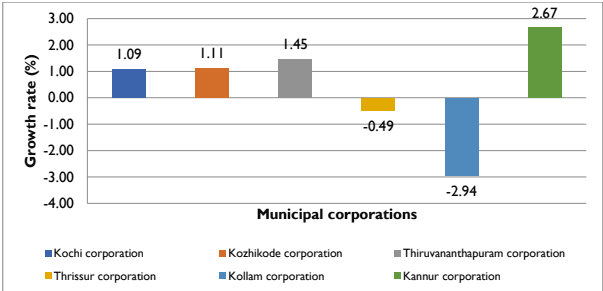
When compared with other municipal corporations,Thiruvanathapuram, Kozhikode and Kannur corporations have slightly higher population growth rates while Thrissur and Kollam exhibits negative population growth rates as shown in figure below.
Kochi Municipal Corporation
DEMOGRAPHY
Figure 4:7 Comparison of Population growth rates with other municipal corporations in the state- 2011 Source: Census -2011
Population Density
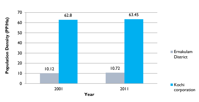
The Corporation of Kochi has a very high density as compared to the surrounding area and it is also the most densely populated city in the state. It has a geographical area of 94.88 Sq.km, which is 1/4th of the total area of KCR, but more than 50% of the total population of the region resides here. The gross, net and residential density was computed from Census 2011 and Land Use survey 2020. The gross density is obtained by dividing number of persons to the net area. The Net area is obtained by deducting the water bodies from the gross area. The density of Kochi Corporation area is 6345 persons per Sq. km which is almost double of the density in Kochi City Region (3190). Population density of Kochi Corporation was 6280 persons/sq.km in 2001 which increased to 6345 persons/sq.km in 2011.The net density of Kochi Corporation is 7857 persons per sq.km while the net density is highest in the state being 16802 persons per sq.km as shown in Table 4-4. The decadal variation of population density of Kochi Municipal Corporation and the district is shown below.
Table 4:4 Gross , Net and Residential Density of Kochi from in 2011
54
Gross area (sq.km)
Gross density (persons/sq.km)
Net area* (sq.km)
Net density (persons/sq.km)
Residential area (sq.km)
Net Residential density(persons/sq.km)
94.88
6345
76.63
7857
35.83
16802.85
Source: LSGD (Planning)
Kochi Municipal Corporation
DEMOGRAPHY
Figure 4:8 Comparison of Population density with Ernakulam district and Kochi Municipal Corporation 2001 - 2011 Source: Census -2011
Table 45 Temporal change of Population Density in Kochi from 2001-2011
Administrative divisions
Area (Ha)
Population in Lakh
Population Density (P/Ha)
2001
2011
2001
2011
Ernakulam District
306300
31.05
32.82
10.12
10.72
Kochi Corporation
9486
5.95
6.02
62.8
63.45
Kochi city region
36972
11.6
11.8
31.5
31.9
Source: Development Plan of Kochi City Region-2031 (draft), Census data
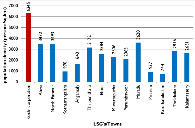
The comparison of population density with other urban local bodies in the District is shown in Table 4:6 and Figure 4:9 . When compared with other Towns, Kochi Corporation has the highest population density. Maradu, North Parvur and Aluva are the next densely populated urban local bodies in the district. Koothatukulam has the least population density of 744 persons per Sq.km.
Kochi Municipal Corporation
DEMOGRAPHY
Figure 4:9 Comparison of population density of Kochi with other urban local bodies in the District Source: Census 2011
Table 46 Comparison of population density of Kochi Corporation with LSGs in the District
District/LSG
Density (Persons per Sq. Km)
Ernakulam District
1072
Kochi corporation
6345
Aluva
3472
North Paravur
3493
Kothamangalam
970
Angamaly
1640
Thripunithara
3172
Eloor
2584
Muvattupuzha
2306
Perumbavoor
2065
Maradu
3620
Piravam
927
Koothatukulam
744
Thrikkakara
2816
Kalamassery
2631
Source: Census 2011
Kochi Municipal Corporation
DEMOGRAPHY
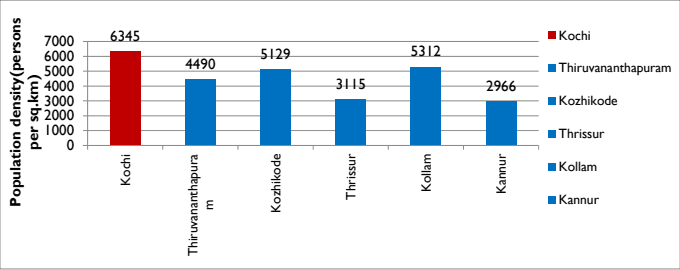
The comparison of population density with other municipal corporations in the state in Figure 4-10 shows that Kochi has the highest gross population density of 6345 among them followed by Kollam and Kozhikode. The density of Thrissur is almost half that of Kochi while Kannur has the least density.
Figure 4:10 Population size comparison Source: Census 2011
Division wise population distribution of Kochi Municipal Corporation is shown in Table below.
Table 47 Division wise population and Area in Kochi Corporation
Division No:
Name
Population
Division Area (sq.km)
1
Fort Kochi
10025
1.23
2
Kalvathy
7825
0.39
3
Earaveli
6455
0.22
4
Karippalam
8917
0.4
5
Mattancherry
10172
0.55
6
Kochangadi
7132
0.25
7
Cheralayi
7721
0.69
8
Panayappilli
11467
0.58
9
Chakkamadam
5066
0.33
10
Karuvelippady
7714
0.41
11
Thoppumpady
9307
1.04
12
Tharebhagam
8829
0.85
13
Kadebhagam
10248
0.54
14
Thazhappu
10753
1.01
15
Edakochi North
9619
1.1
16
Edakochi South
7836
1.99
17
Perumpadappu
9480
0.74
18
Konam
9949
1.26
Kochi Municipal Corporation
DEMOGRAPHY
19
Palluruthy-Kacherippady
11196
0.67
20
Nambyapuram
8782
0.51
21
Pullardesom
11086
0.71
22
Mundamveli
10949
1.15
23
Manassery
8443
0.84
24
Moolamkuzhi
8151
0.71
25
Chullikkal
6644
0.47
26
Nasrath
7310
0.47
27
Fort Kochi Veli
6295
0.67
28
Amaravathy
9487
0.67
29
Island North
3133
5.38
30
Island South
2382
2.27
31
Vaduthala West
7835
1.03
32
Vaduthala East
8996
0.62
33
Elamakkara North
9053
0.91
34
Puthukkalavattom
8592
1.04
35
Ponekkara
9018
1.19
36
Kunnumpuram
8787
1.12
37
Edappalli
7631
2.06
38
Devankulangara
9215
1.62
39
Karukappilli
8647
1.44
40
Mamangalam
7645
0.71
41
Padivattom
5795
1.01
42
Vennala
4420
1
43
Palarivattom
11782
1.54
44
Karanakodam
9756
1.22
45
Thammanam
9394
1.21
46
Chakkarapparambu
8619
1.12
47
Chalikkavattom
9984
1.89
48
Ponnurunni East
6559
0.98
49
Vyttila
4974
1.02
Kochi Municipal Corporation
DEMOGRAPHY
62
Ernakulam South
4378
1.49
63
Gandhi Nagar
5971
1.35
64
Kathrukadavu
8764
1.59
65
Kaloor South
9900
1.34
66
Ernakulam Central
8099
1.29
67
Ernakulam North
8774
0.91
68
Ayyappankavu
4113
1.1
69
Thrikkanarvattom
5998
1.98
70
Kaloor North
9049
1.4
71
Elamakkara South
10215
0.74
72
Pottakkuzhi
10542
0.82
73
Pachalam
5965
0.61
74
Thattazham
7911
1.23
Source: Kochi Municipal Corporation and LSGD (Planning)
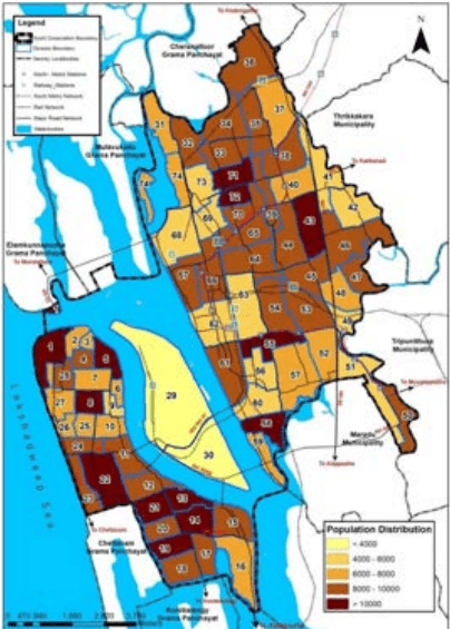
Figure 4:11 Division wise distribution of population of Kochi Corporation 2011 Source: Census 2011
Kochi Municipal Corporation
DEMOGRAPHY
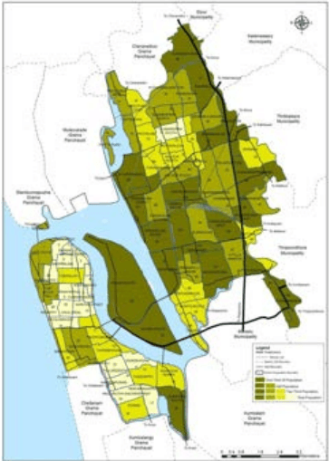
Palarivattom division (Dn 43) is having the maximum population of 11782 persons and Island South (Dn 30) is having the minimum population with 2382 persons. More populated divisions are located in the eastern sides of the mainland and Fort Kochi –Mattancherry area. Divisions in the central city area are less populated.
4.4.1 Net population density
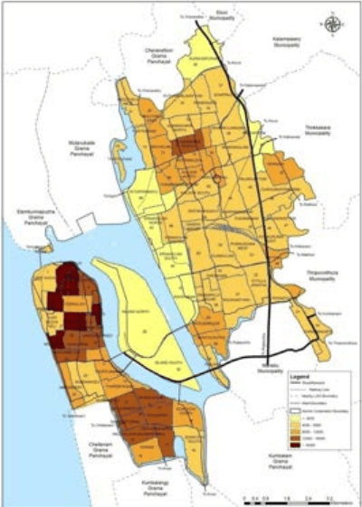
Net population density is highest in Earaveli Dn (3), 35608 pp/sq.km followed by Kochangadi Dn (6) with 27370 pp/sq.km. This is followed by Amaravathy Dn (28), Nasrath Dn (26) and Kalvathy Dn (2) which is almost equal to 20000 pp/sq.km. The division wise net population density of Kochi Municipal Corporation is shownin Figure below.Island North division (30) in Willingdon has the least population density of 581 pp/sq.km.
Figure 4:12 Division wise net population density of Kochi Corporation (2011census) Source: Census 2011
60
Kochi Municipal Corporation
DEMOGRAPHY
Highest population density is seen in the Fort Kochi –Mattancherry area and southern divisions of West Kochi. Northern and southern divisions of the mainland also show relatively high population density while the least in seen in the Island area. Central city area has very low population density compared to the other areas. (Below 4000 pp/sq.km)
4.4.2 Population concentration pattern
The population concentration pattern within the town, derived by mapping the cumulative population in the order of their gross densities, is presented in Figure below. Comparing with the slope of the terrain, it can be seen that population is concentrated in the low-lying and well-connected areas. While 1 / 3 r d of the total population in the town is concentrated in 43% of the municipal area, half the population is concentrated in less than 65% and 2 / 3 r d of the population is concentrated in less than 77% of the total area.While this reveals the areas where infrastructure and service provisions need more focus, it also suggests the presence of vast tracts of less-developed land in the peri-urban areas of the town.
Figure 4:13 Division wise population Concentration pattern of Kochi Corporation (2011census) Source: Census 2011
Kochi Municipal Corporation
DEMOGRAPHY
4.4.3 Net Residential Population density
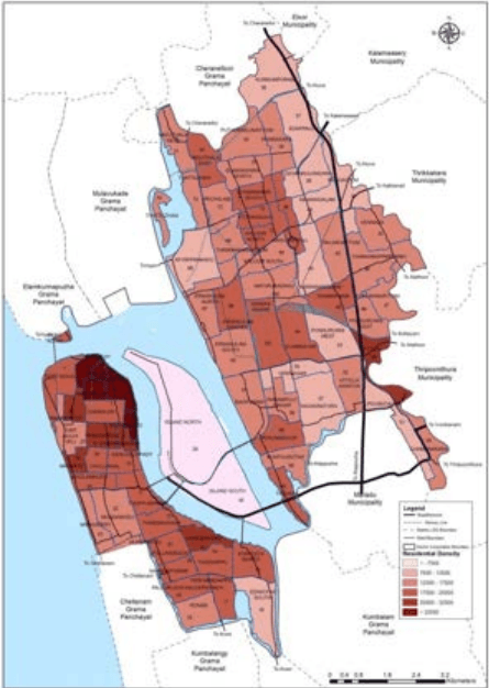
Net residential population density of 20 divisions in the city is more than 20000pp/sq.km. It is highest in Earaveli Dn (3), 59617 pp/Sq.km Kochangadi Dn (6), 54259 pp/sq.km followed by divisions Mattancherry (5), Karipalam (26) and Kalvathy (2) as shown in Figure below. Island North division (30) in Willingdon has the least net residential population density of 5073 pp/sq.km. Highest population density is seen in the Fort Kochi –Mattancherry area and southern divisions of West Kochi. Northern divisions of the mainland also show relatively high population density while the least in seen in the Island. Central city area and Island has very low population density compared to the other areas.
Figure 4:14 Division wise Net Residential Density of Kochi Corporation (2011 census) Source: Generated from Census 2011, Landuse survey 2020