The primary goals of the Disaster Management are to reduce the likelihood that the City will experience disaster and to mitigate the impact of any disasters that do occur in the City. Intensity of disaster can be reduced by identifying and correcting hazardous conditions by encouraging alertness in detecting and reporting. This calls for a preliminary identification of the major disasters affecting the city and the areas prone to disaster. The Kerala State Action Plan on Climate Change was drafted by the Directorate of Environment and Climate Change (DoECC) with relevant departments, agencies and institutes providing inputs. This was endorsed by the Government of India in 2014. The Ernakulum city currently holds a Disaster Management Plan prepared in the year 2015 by Kerala Disaster Management Authority. However, events like the flood of 2018 and unpredictable climactic events that may occur in the future owing to climate change needs to be considered while planning for the Kochi city.
Climate change effects in Kochi
The effects of climate change on the Earth’s environment will be manifested most directly through four mechanisms. First, although some anomalies are to be expected, most climate experts agree that human-induced climate change will increase average global atmospheric and sea surface temperatures. Second, temperature increases will be associated with changes in precipitation patterns worldwide. Third, changes in storm tracks and intensities are likely to occur. Fourth, the sea level is expected to rise due to a combination of thermal expansion and the melting of mountain glaciers and the polar ice caps. Although most climate change forecasting models imply relatively gradual changes in these regards, it is widely agreed that climate change is likely to be accompanied by increased climate variability and by an increased risk of extreme events and surprise2.The draft report of the United Nations Intergovernmental Panel on Climate Change released in 2019 , which warns of devastating rise in temperature and sea level, has raised concern about possible inundation of Kochi with the global sea level rise ranging from 0.5 – 2m for the next century, as the elevation from sea level is less for Kochi.
The major impacts of this would be
615
• Loss of large chunks of urban and rural areas in Cochin.
2Possible Vulnerabilities of Cochin, India, to Climate Change Impacts and Response Strategies to Increase Resilience, June 2003, Oak Ridge National Laboratory and Cochin University of Science of Technology
Kochi Municipal Corporation
DISASTER MANAGEMENT
• Increased chances of coastal flooding and water logging along with intense storm events which might even affect structural stability of buildings.
• Loss of tourist places and thereby economic and livelihood support gained from them.
• Salt water intrusions in both surface and ground water along with loss of fertile lands
• Increase in temperature which would cause higher demand for potable water and electricity for cooling.
• Negative impact on the fishes and corresponding fisheries community.
Combination of change in temperature and precipitation can change local human and natural ecologies, like for example impacts on human health with changes in pests and pathogens to which people are exposed and the associated health requirement.
22.2.1Sea level rise
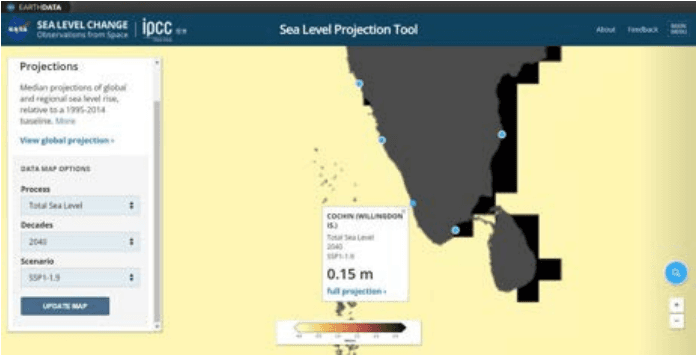
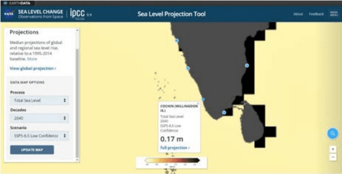
The recent IPCC (Intergovernmental panel on climate change) study released in 2021 gives out a much more alarming picture for Kerala and especially Kochi. Based on the report by NASA it expected that 12 coastal cities of India may be submerged by the end of the century due to climate change. These cities may be filled with sea water upto 3 feet as per the projections. The sea level projection tool developed by NASA predicts the following.
NASA has developed a projection tool (https://sealevel.nasa.gov/ipcc-ar6-sea-level-projection-tool ) and distilled the report for policy makers. In Kochi Willington island is considered as the base station. There are 5 SSP scenarios (Shared Socio economic pathways). The greenhouse gas concentrations for these 5 scenarios with different future socio-economic projection and political environment are considered. SSP1-1.9 aims for a world with green growth (sustainable environment) whereas SSP 5-8.5 depicts the worst case scenario with no control over usage of fossil fuels. On an ideal level , SSP1-1.9 is the best scenario but the highest priority is given to achieve the SSP 1-2.6 scenario which reflects close to the target 1.5oC under Paris agreement. ‘SSP 1-2.6 low confidence’ is the worst case exclusive to that category.
Kochi Municipal Corporation
DISASTER MANAGEMENT
Figure 22:1 A rise of 0.15m predicted for 2040 in best case scenario (SSP1-1.9) Source : sealevel.nasa.gov/ipcc-ar6-sea-level-projection-tool
Figure 22:2 A rise of 0.17 m predicted for 2040 in worst case scenario (SSP5-8.5) Source : sealevel.nasa.gov/ipcc-ar6-sea-level-projection-tool
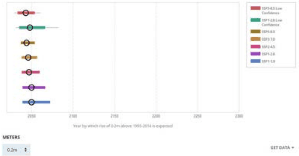
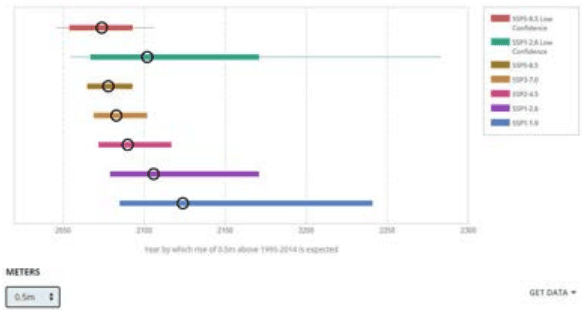
The figure below shows a confirm rise in sea level of 0.2 m on reaching the year 2050 in all scenarios and Figure 22:4 shows a sea level rise of 0.5 m in a gap between 2050 to 2100.
Kochi Municipal Corporation
DISASTER MANAGEMENT
Figure 22:3 0.2m sea-level rise expected at 2050
Figure 22:4 0.5 m sea-level rise expected at a gap of 2050 to 2100
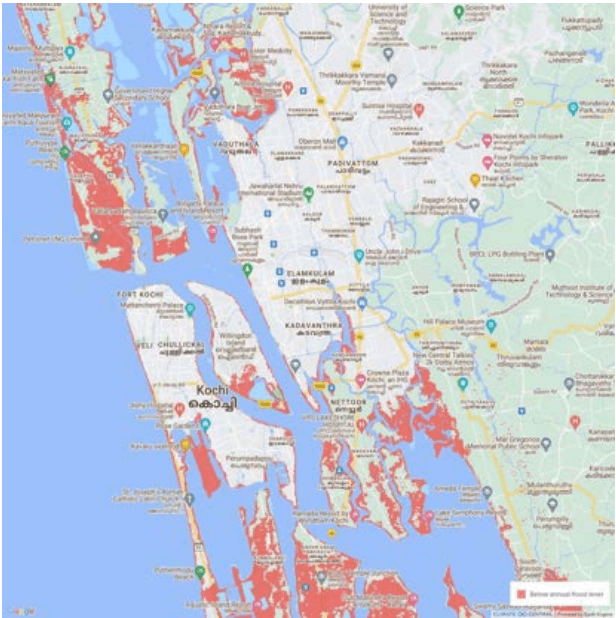
"Annual flood level" is used to denote the water level at the shoreline that local coastal floods exceed on average once per year. In other words, ten floods are statistically expected to exceed this level over ten years, although some years might have two or more incidents, and other years none. Below is the areas that expected to be below annual flood level in the year 2050 as per the screening tool developed by Climate Central, USA. Areas lower than the selected water level and with an unobstructed path to the ocean are shaded red. The
Kochi Municipal Corporation
DISASTER MANAGEMENT
maps are based on global-scale datasets for elevation and tides in addition to sea level rise projections.
Figure 22:5 Land projected to be below annual flood level in 2050
Disaster risks in Kochi
The geographical location and urbanization have made Kochi one of the most disaster prone areas. The major risks involved are,
• Geological;
• Water and Climate related
• Chemical and Industry related
• Biological
• Accident related
Kochi Municipal Corporation
DISASTER MANAGEMENT
Table 221 Hazard Seasonality mapping of the district
Disaster
Jan
Feb
Mar
Apr
May
Jun
Jul
Aug
Sept
Ooct
Nov
Dec
Earthquake
Drought
Wildfire
Lightning
Flood
Cyclone
Coastal erosion and storm surges
Tsunami
Landslide
Epidemics
Road/waterrelated accidents
Source: District Disaster Management Plan, 2015 Ernakulam and KSDMA data
The monsoon season ticks majority of the disaster risk categories with likely occurrence of disasters like flood, landslides , viral infections and mosquito related diseases, coastal erosion and storm surges. The storm surge also occurs during the November to December with occurrence of more high tides. Summer season also holds a break out water related diseases like jaundice, typhoid etc. Occurrence of earthquake and tsunami is majorly geological related and is expected at any time of the year.
Vulnerability of Kochi
The terrain of Kochi within the coastal wetland zone is highly fragile. Indiscriminate reclamation is permanently damaging the eco system. Cyclones and local severe storms have occurred in Kochi at 5 to 6 times during the last 100 years. Coastal erosion and storm surges are constant phenomena in Kochi. Flooding and water logging is another calamity occurring every year during monsoon, disrupting the activities of the region. The recent Flood in 2018 affected the coastal areas of Kochi resulting in losses of life and belongings. The location of the major chemical industries and petroleum installations pose serious threats of disaster occurrence like oil spills into the ocean and disasters related to leakage of gases which could be spread to the major city area with the westerlies. The very common biological threat includes mosquito vector diseases occurring with the rain showers. Apart from this the recent advent of CORONA virus disease has shook the world being classified as a global pandemic. Proper hazard management programme relating to all the vulnerable conditions is essential in city development.
Kochi Municipal Corporation
DISASTER MANAGEMENT
Kochi city is specifically vulnerable to the changing climatic dynamics owing to its location along the sea coast and steep gradient along the western slopes of the Western Ghats. High population density in coastal areas adds to the vulnerability. Therefore, as a consequence of global warming and climate change, sea level rise poses a very major threat.
Table 222 Damages caused in past years due to Disasters
Type of Disaster
Year
No. of Houses Damaged/ Individuals affected
Floods
2018
2315 Houses
Cyclone (Okhi)
2017
2648 evacuated
Others (Sea erosion, Wind, Rain)
2013
224 Houses
2014
347 Houses
2015
147 Houses
2016
197 Houses
2017
170 Houses
Source: Taluk office, Kochi and Kanayannur
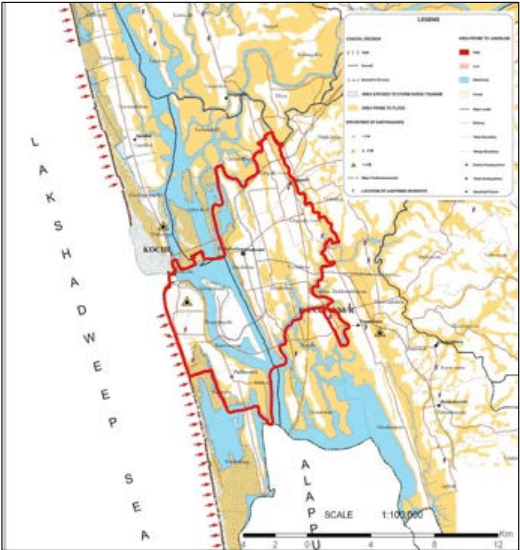
Figure 22:6 Multiple hazard zonation map
Source: Kochi Municipal Corporation website, prepared by KSDMA in 2009