Kochi is characterized by an almost flat topography and high water table. On an average, the eastern parts of the district are situated approximately 7.5 metres above mean sea level, while much of Corporation of Kochi lies between 1 - 2.5 metres above mean sea level. Further, the city has sand bars running from the north to the south, with several tidal canals in between. The climate in Kochi is tropical and the city enjoys monsoons twice a year, translating to annual rainfall of approximately 3,099 mm. The southwest monsoon, which usually lasts between June and September, brings around 60% of the annual precipitation, while the Northeast monsoon, which takes place between October and mid-November, typically brings about 25% of the annual rainfall in the region.
Drainage system
Cochin is dissected by numerous canals and backwaters which forms part of the Vembanad backwaters. Managing the quality and quantity of the waters in these tidal canals is of utmost importance so far as the quality of life is concerned. The drainage system in the area can be categorized into three levels as:
12.1.1 Primary canals:
These are major natural canals, which are running in north-south direction and a few natural canals that cut across the sand bars. The primary canals which convey the storm water runoff to the back water system which were once navigable are now highly degraded because of encroachments, waste dumping, silting, weed growth, low maintenance and lack of protective measures.
Table 121 Table showing the Primary Canals in Kochi Municipal Corporation Area
1. Thevara - Perandoor canal
2. Chilavannoor Lake
3. Changadampokkuthodu (Barge Way Canal)
4. Karanakkodamthodu
5. Edappally Canal
6. Mullassery canal
7. Chittoor puzha
8. Rameswaram canal
9. Punchathodu
10. Karee thodu:
11. Adimurythodu
12. Pashnithodu
13. Pallichalthodu
14. Thevara Canal
15. Market Canal
16. Muttar River
17. KannachanThodu
18. Poornipuzha
Kochi Municipal Corporation
DRAINAGE
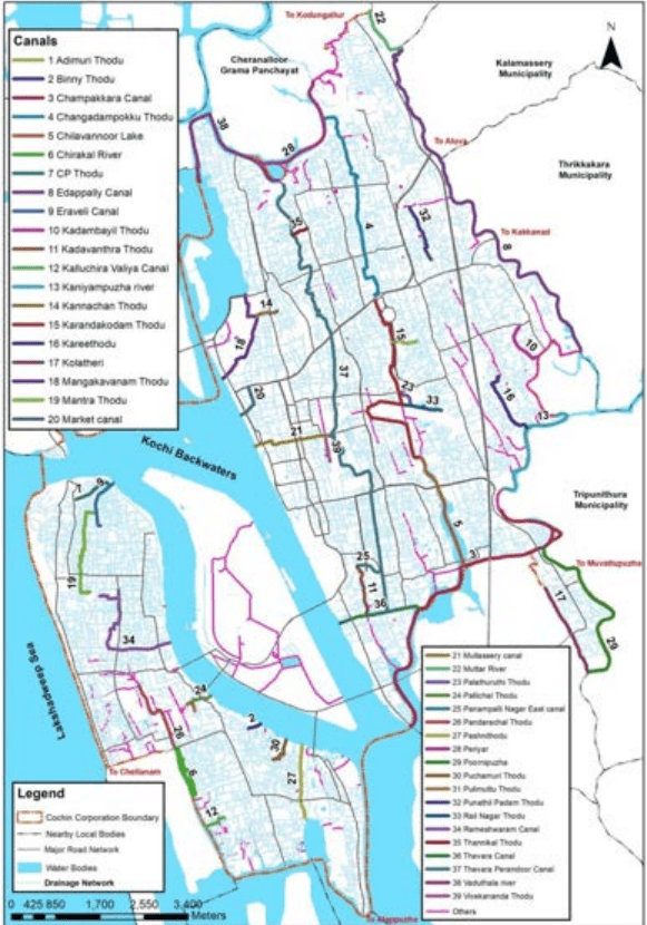
The important canals flowing in the corporation area are listed in the table above. Canals that are identified for the study are illustrated in figure 12-1.
Figure 12:1 Map showing major canals in Kochi Corporation area Source: Irrigation department, CoC 2020
Kochi Municipal Corporation
DRAINAGE
Thevara - Perandoor canal: Thevara – Perandoor canal also known as TP Canal is the primary drainage artery of Kochi Corporation. Having a length of about 9.95 km, it connects Perandoor on the north with Thevara in the south. It is a man-made canal that was once used for navigation, fishing, irrigation, recreation, flood alleviation and goods transportation. Kottayam-Ernakulam railway line has divided this canal into two. TP Canal runs through the centre of Kochi Corporation ie Panampilly Nagar, Kadavanthra, KSRTC, Kaloor and drains to Perandoor Kayal near Elamakkara/ Ponekkara. The catchment area of TP canal is about 30 sq. km and storm water/ Drainage water reaches TP Canal even from 1.5 km on both sides of the canal. The catchment area of TP canal is about 30% of the area of Kochi Corporation. Over the years, TP canal has become the repository of urban liquid and solid discharges. This canal has significant urban relevance in the present settings. Rejuvenation and committed maintenance of this canal could give a tremendous boost to the aesthetic appeal of the urban environment. .
Thevara - Perandoor Canal near Kaloor market
403
Changadampokkuthodu (Barge Way Canal): This canal links Kaloor with the Chittoor puzha/ Perandoor river. The Changadampokku Thodu and Karanakkodam thodu was originally connecting Perandoor puzha on the north and Chilavannoor kayal in the south and flows in between them. As the name indicates, this canal was developed for inland navigation. As the name implies, large wooden rafts or Changadams was plying through this canal for conveying materials from Perandoor river. However the connectivity of the two canals were lost in the developments that happened at Jawaharlal Nehru International Stadium near Kaloor. The water was used for fishing, washing, irrigation and bathing. Paddy fields flourished on either side of the canal. The canal tails out at the western boundary of the international stadium and south flowing Karanakkodom thodu begins where Changadompokkuthodu ends. Excessive waste load has ripped off the economic utility of the canal.
Kochi Municipal Corporation
DRAINAGE
Karanakkodamthodu: Karanakodam thodu is a part of Chilavannoor canal and it starts from the western side of JLN Metro station traversing towards south and ends at Elamkulam, where the water drains to Chilavannor kayal. Railway marshalling yard has altered the natural course of the canal. Once it was used for fishing, navigation, washing, bathing and irrigation. Earlier people depended this thodu to reach Edappally from Thripunithura and were used for the transportation of goods also. Now this thodu is seen separated into two at the Banerjee road near JLN metro Station. Now the thodu towards north is Changadampokku thodu and towards south is Karanakkodam thodu. Discharges from the sewage treatment plant have led to conspicuous eutrophication at Chettichira. Domestic and Municipal wastes are directly discharged into the water body. At the beginning of the canal, water is anoxic and stinking during dry spells whereas, down south water is comparatively better.
404
Mullassery canal: The Mullassery canal is a 1.4 km long waterbody passing through the prime commercial area of Kochi city in east – west direction. It begins from Perandoor Canal near KSRTC bus station and discharges into Kayal near children’s park at Marine Drive. Urban development has transgressed into the canal space in many parts along its length. Most of the portions of the canal are covered by concrete slabs and are being used as roadway, parking space, access to commercial establishments/ residences etc. Water is stagnant and anoxic. The canal begins at a low-lying area around Ernakulam South Railway Station and the natural gradient is not conducive to smooth flow of floodwaters. Water is turbid and coloured. Concrete slabs have been built on top of the canal at some places. The canal traverses towards west along Mullassery Canal road and afterwards crossing major roads such as Chittoor Road, MG Road, TD Road, Market Road and Park Avenue Road.
Mullassery Canal
Kochi Municipal Corporation
DRAINAGE
Chilavannoor Lake: Chilavannoor lake is a prominent water body located near Chilavannoor in the heart of Kochi City. It is the part of Vembanad back waters. The Rail Nagar thodu and Karanakkodam thodu discharges to the Chilavannoor lake. The Chilavannor lake extends from Subhash Chandra Bose road towards south upto Chilavannoor bridge on the tank bund road. The Chilavannor lake is heavily silted due to the lack of proper maintenance. Hence water carrying capacity of the lake has reduced.
Edappally thodu: This major canal connects the Muttar River on the northwest with the Chithrappuzha on the southeast. Edappally thodu forms the boundary of Cochin Corporation at the eastern side. Before urbanization reached the present levels, this canal was the chief commercial link of Edappally. It is the link between the two industrial hubs, Udyogamandal and Ambalamugal. It functioned as the boundary between erst while Travancore and Kochi kingdoms. The water was reportedly less turbid and was used for fishing, irrigation, recreation and navigation. At present NH-47 has cut the canal into two halves. The northern half is in a very bad shape by siltation, unwieldy outgrowth of weeds, clandestine solid waste disposal and neglect. The southern half is comparatively better off. Since agricultural activities have tapered off water is not any more used for irrigation. To the east of this canal the lateritic midland undulations become more pronounced. The alluvial bars and associated wetlands in between Edappallythodu and the backwaters are being subjected to anthropogenic modifications as part of accommodating the demands of urbanization.
Adimurythodu: It begins at Palarivattom and joins Karanakkodamthodu behind the International stadium. Domestic biological waste, mostly faecal contamination, has turned the water unhygienic. Water is anoxic at the confluence.
Punchathodu: This was developed as a natural drainage amidst the paddy fields (Punchappadam). The canal begins at Palarivattom and crosses NH Bypass north of Vyttila, flows south and joins Kaniyampuzha. The water was once used for irrigation, fishing and navigation.
Karee thodu: It runs parallel to Punchathodu and joins Kaniyampuzha. It evolved as a farmland drainage system. Once it was used for irrigation, fishing and small-scale navigation.
Poornipuzha: It is one of the arms of Champakkara canal stretching to Trippunithura and down south to Vembanad estuary. The canal crosses a flat wetland, where Andhakaranthodu joins it. It was used extensively for navigation and fishing. Now fishing continues to a limited extent. The water is saline for most part of the year. Municipal waste from Trippunithura municipality ends up here.
Kochi Municipal Corporation
DRAINAGE
Chittoor puzha/ Periyar river: It is a circular water body having direct link to the Periyar estuary and the Muttar River. Both Thevara-Perandoor canal and Changadompokkuthodu end up in Chittoor puzha which is a part of Periyar River. The constriction of Perandoor railway culvert obstructs smooth exchange of water between Thevara-Perandoor canal and Chittoor puzha. It receives a heavy dose of municipal waste from T P canal, Changadompokkuthodu and Aryanpadom thodu.
The north-western side of the canal merges with a branch of Periyar, which is part of the ammonia barge route to FACT, Udyogamandal. There are two freshwater courses ending up in this canal – Perandoor thodu and Changadompok thodu. Siltation and outgrowth of grass and aquatic weeds have thwarted the smooth flow of water further north..
Pashnithodu: It is a man-made canal built during the world war famine connecting Kaithappuzha kayal and Perumpadappu kayal. Water is turbid and unhealthy. Discharges from various fish processing industries make its waters unfit for any economic activity. Fish kills are regularly reported. However, fishing is going on at the kayal opening.
Pallichalthodu: It is a small canal running across Thoppumpady evening market to Kochi kayal: The water is ash-coloured anoxic slurry. It drains the market refuse and tidal action purges the canal to a certain degree.
Rameswaram canal: Remeswaram Canal represents the state of all the canals of Fort Cochin Mattanchery region. This is a man – made canal constructed by Portuguese for sailing boats. It starts from Vembanad lake near Cochin Fisheries Harbour at Karuvelippady and meets Vembanad lake where Periyar merges with the Arabian sea near Fort Kochi boat jetty. Rameswaram canal and its allied canal systems had been a hub of international trade in Kochi for centuries. Its present condition portents regular outbreaks of water borne epidemics. Navigation is possible in limited segments at the openings.
Rameswaram Canal
Kochi Municipal Corporation
DRAINAGE
Thevara Canal: Thevara Canal starts from Vembanadu kayal and ends at Chilavannur kayal. This kayal is having a length of 1.4 km and average width of 20 m. Koithara Canal, Konthuruthy canal and Thevara-Perandoor Canal are connected to Thevara Canal. The outflow from these canals reaches to the backwaters through Thevara canal.
Market Canal: Market canal starting from Ernakulam market at Bannerji road for a length of 730m discharges into the Kayal at the rainbow bridge having an average width of 9.60 m. History of Market canal starts at the era of “ The Maharaja of Cochin” about 150 years back who gave the Market area to Jewish traders for business. The northern end of Broadway, Basin Road and Jew street together forms the Ernakulam market with a row of temporary shacks come up on the side of Basin road with their back to the canal. Hence the canal also known as Basin Road Canal. Market canal used to be the lifeline of business in the market with the country boats bringing in goods until the 90’s as it is directly linked to the Vembanadu lake. As such the centre had trade connections from as far as Ponnani and Chavakkad in North and Kollam, Changanassery, Kottayam in south. The wide platform that protrudes the canal is the jetty where hundreds of large canoes carrying goods used to arrive from these places.
Muttar river: Muttar River is a major tributary of Periyar. The river is a major source of water for Aluva, Choornikkara, Kalamassery, Kadungaloor, Alangad, Cheranalloor, Varapuzha and parts of Kochi Corporation. Muttar river is currently under threat of pollution from nearby industries. It is the connecting link between Edappally canal and Periyar river
407
Kannachanthodu: Kannachan Thodu was one of the Hero distributary originating from Perandoor canal and driving down the shortest distance to reach Vembanadu kayal through Mangalavanam bird sanctuary near Terminus Railway station and High Court of Kerala. Many parts of the original Kannachanthodu is currently blocked thereby causing water logging in the surrounding areas.
It is found that almost all the tidal canals are in filthy condition. This is due to the dumping of wastes into the canals and lack of facilities for cleaning them due to inaccessibility of cleaning vehicles and machines. It is necessary that this canal and the shorelines are protected and maintained properly for better living conditions. Many of these canals were man-made when wetlands were reclaimed for paddy cultivation. Canals were developed to drain away excess water. This explains the genesis of canals like Punchathodu, Khari thodu, Karanakkodamthodu, Adimurythodu etc. Edappallythodu, TP Canal, Changadompokkuthodu, Pashnithodu etc were developed by man to facilitate navigation.
Kochi Municipal Corporation
DRAINAGE
12.2.1 Natural and manmade secondary drains:
Natural secondary drains are the feeder drains/canals of primary canal. The man-made secondary drain encompasses major roadside drains, which go beyond the level of area drains. They link with the Primary drains (tidal canals) running in north-south direction.