Structure Plan for the Central City of Kochi was prepared by the GCDA, with the technical advice and helps of the Department of Town Planning, as per the provisions of the Travancore Town Planning Act 1108 and Madras Town Planning Act 1920 and was sanctioned by Government as per G.O. (Ms) No. 103/91/LAD dated 20.3.1991.This is a Policy Plan for the development of the region with broad land use proposals for the area within the city and the immediate surrounding areas.
The Plan period assumed in the Structure Plan was from 1991 to 2001.Urban expansion during 1971- 81 outgrew the limits of the Central City area delineated in the Development plan for Cochin Region, 1976.
Growth trend of settlements of the region was different from what was anticipated and the population growth of rural areas far exceeded that of the urban areas. Hence the suburbs showed higher growth rates than the city proper. The Cochin Urban Agglomeration, as per 1981 census, included the Cochin Corporation, Thripunithura Municipality and census towns of Eloor and Kalamassery and Thrikkakara (Urban OG).In the light of the above, certain modifications were effected in the boundaries of the Central City considering the following norms:
i. The central city should include the whole of the UA to account for the existing urban spread
ii. The central city should include census towns contiguous to the urban agglomeration to accommodate potential urban growth
iii. The central city should include areas intervening between the boundary of UA and census towns satisfying the conditions of growth possibility and viability
iv. The boundary of the central city should encompass the full administrative boundaries of the constituent local bodies for effective implementation of plan proposals
v. The central city should necessarily form a compact area wherein developmental efforts could be focused.
Kochi Municipal Corporation
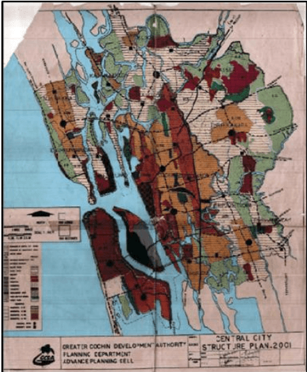
Figure 2:1 Sanctioned map of Structure Plan for Central City Kochi-2001 Source: Structure Plan for Central City Kochi-2001
Structure Plan, the Central City as newly delineated include the Cochin UA (Cochin Corporation, Eloor, Thrippunithura, Kalamassery and Thrikkakara), Census Towns (Mulavukadu and Maradu) and viable panchayats (Njarakkal, Elamkunnappuzha, Cheranelloor, Thiruvankulam and Kadamakkudy) and covered an area of 275.85 sq km with population of 8.55 lakhs as per 1981 census and was estimated to be 10.07 lakhs in 1991 and 11.42 lakhs in 2001. The population of Cochin Region as per 1981 Census was 14.82 lakhs.
The Structure Plan envisages long-term and short-term measures for ensuring the cohesive development of the Central Area. The plan mainly deals with control mechanisms for guiding the future urbanisation and positive actions to be taken up by various development Agencies. The plan calls for concentrated and programmed course of actions among various development agencies functioning within the area as well as healthier interaction of the public and government agencies. The Structure Plan contains scheme for population distribution and plans for traffic network and land use. The plan for population distribution was aimed towards restricting the urban growth within the boundaries of the Central City and ensuring a balanced
Kochi Municipal Corporation
distribution of future population within a central city for optimum utilization of urban land consistent with the economics of the land market mechanism and the socio-cultural values of the people. It was proposed to divide the Central City into seven planning divisions. These divisions were envisaged as more or less self-contained settlement of communities with regard to their requirement of work places, residential accommodation, shopping, community facilities and recreation. The details are as follows:
The Corporation of Cochin was sub divided into three areas.
The oldest settlement on the western side of the city constituting Fort Cochin and Mattancherry together with Edacochin and Wellington Island formed the first planning division
Northern side of the city consisting of Pachalam and Edapally zones of the Corporation, a contiguous area with identical planning problem, formed the second planning division.
The Central Business District (CBD), Panampally Nagar zone and Maradu Panchayat formed the third planning division
Thrippunithura Municipality and Thiruvankulam Panchayat possessed close interaction in social, economic and physical function, and formed fourth planning division.
Thrikkakara and Kalamassery Panchayat had similarity of terrain and type of development and hence were identified as fifth planning division.
The Panchayats of Eloor, Cheranellur and Kadamakkudy formed a homogeneous unit for planning purpose as they had interdependency for transportation, work and community facilities. This formed the sixth planning division.
The coastal panchayats of Njarakkal and Elamkunnappuzha together with Mulavukadu Panchayat constituted the seventh planning division.
Future population and densities were assigned to the planning divisions based on the holding capacity and future growth trend of each of the divisions. The assigned population formed the basis of working out the plan for each of the divisions. Each of the planning divisions was further sub divided into communities with population ranging from 30000 to 40000. Such a division was meant to facilitate the provision of community needs and services without imbalances in the development of division. Area under each of the planning divisions was divided into well-defined zones specifying the land use and density of population. The control of land use and density was to be achieved through zoning regulations. The density in the core
Kochi Municipal Corporation
division was kept high because of the restrictions imposed by the services in this area. In the peripheral divisions, the density was assigned low so as to provide space for future planned growth. The traffic network plan was aimed as arteries of urban mobility. The city level plan proposed the following:
Eight radial roads (primary distributors), providing direct linkage between the city and major growth centres in the region and environs (Cochin-Munambam, Cochin –Parur, Cochin – Alwaye, Cochin – Perumbavur, Cochin- Moovattupuzha, Cochin –Vaikkom, Cochin – Cochin –Alleppey and Cochin – Chellanam)
Three ring roads, to link the radial roads together to achieve inter connection between them at various distances from the centre of the town (Inner ring road – Elamkulam – Kaloor, Kaloor – Perandoor Road forms part of this, Middle ring road – Segment of NH bypass, NH 47 and coastal highway NH-17 formed part of this; and outer ring road – proposed to link directly the industrial zones and other work centres lying in the peripheral areas of the city. This would also open up the sparsely built up land for industrial and housing development)
Secondary road network, to ensure accessibility for all parts of the city to the public transportation. This linked to the radial roads and ring roads formed the basic network of development. One major policy in allocating the secondary road network was to ensure that no point in the city is located farther than 1 km walking distance from the bus routes. Other proposals included improvement of junctions, creation of grade separated foot paths and cycle lanes, allocation of parking space, two central bus stations (one for KSRTC and another for all the private buses to be located close to each other), city service stations, transit stations at interchanges road, rail and water ways wherever they are integrated, truck terminals and proposals for improvement of inland water ways and renovation of canal system.
The land use plan of the Central City was evolved with consideration (i) to make sufficient land available for the prime activities as per space standards; (ii) to achieve a balanced development of the city by decentralizing the work centres related to the population distribution; and (iii) to guide the urban development in an orderly manner by emphasizing the services at different level. The land use plan proposed to accommodate major share of the future land requirement for commercial use in the CBD areas and planned sub centres and community centres, to promote a concentration of activities in specific nodes of the city thereby preventing the proliferation of such activities all over the urban area. It was proposed to keep the CBD areas and the heavily built up areas of the city for detailed study and area redevelopment in a phased manner. The CBD functions were to be decentralized by initiating 8 planned sub centres in the city. The sub centres were conceived as an integrated facility of
Kochi Municipal Corporation
commercial, institutional and industrial uses to serve the population of the planning division. For the community needs of the urban population 24 Community Centres, (each serving a population of about 30000 to 40000) were proposed. The land use plan also proposed for extension of land under industrial use near existing large scale industries, allocation of land for new industrial zones for export production and planned industrial growth. The institutional buildings, offices etc were proposed to be distributed in the CBD area, the sub centre and the administrative complex at Thrikkakara. The community uses were to be distributed in the residential areas and community centres. The land presently under agriculture was proposed to be retained as a buffer stock and only very low density permitted, but part of land was proposed to be converted into developed land The major proposals in allocation of land under traffic and transportation were (a) development works of port, airport and railways (b) completion of all roads and bridges in the primary and secondary network designated in the plan and widening of roads at the tertiary level (c) development of traffic terminals (d) development of boat jetties and inter-change points. Proposal for development of a major city park, a botanical garden, a green strip with parks and specialized recreational activity areas, play grounds and sports fields and community open areas catering to different levels were also included in the Plan. Government , as per GO(MS)NO.143/07/LSGD dated, TVM, 31st May 2007, have varied ‘Part IV, Zoning and Sub division regulations’ of the Structure Plan for Central City, Kochi for the purpose of making the zoning regulations compatible to the present development scenario, as an immediate measure, until the scheme is further varied after detailed studies.