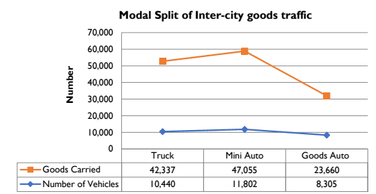
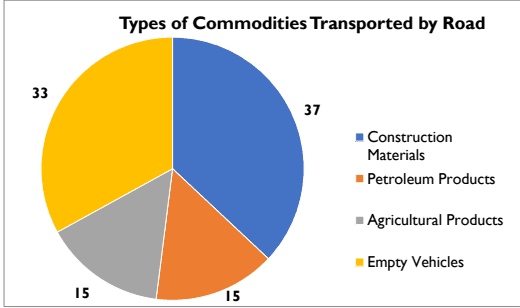
Origin-destination surveys and link volume surveys were conducted to study the inter-city passenger and goods movement pattern in Kochi city. An analysis of these traffic movements will give the proportion of bye-passable traffic along with the major external interaction areas. The survey was conducted at nine entry/exit points of the city. The list of the cordon points are given in the table below.
| Sl.No | Name of Location | Name of Road |
|---|---|---|
| 1 | Near Vyppin | High Court -Vyppin - Munambam road |
| 2 | Near Vaduthala bridge | Chittoor road |
| 3 | Near Kunnumpuram | NH-66: Paravoor road |
| 4 | Edappally bridge | NH-544: Aluva road |
| 5 | Alinchuvadu | Kakkanad road |
| 6 | Petta bridge | Thrippunithura road |
| 7 | Chembakkara bridge | NH-66 Bypass |
| 8 | Aroor Old bridge | Old NH-66 |
| 9 | Corporation boundary | Chellanam road |
Source: NATPAC study report, 2019
O-D surveys were carried out continuously for a period ranging from 16 to 24 hours on a normal working day depending upon the intensity of traffic flow. During the survey, passenger and goods vehicles were stopped at random with the help of police to collect trips particulars of the traveling public and motor vehicles. Particulars like origin of trip, final destination, travel
Kochi Municipal Corporation
TRANSPORTATION
distance, number of passengers in the vehicle, purpose of journey, occupation etc., were collected from the passenger vehicles crossing the survey station. In the case of goods vehicles, details like origin and destination of goods traffic, type of commodity carried, quantity carried etc. were collected. An analysis of the survey data has revealed the proportion of inter-city traffic that could be diverted from the town roads. Besides this, the analysis has identified the major traffic generating points within the influence area of the town.
8.4.1.1 Inflow and Outflow of vehicular traffic
The outer-cordon survey of vehicles entering and exiting Kochi city revealed that during the survey period of 24 hours, the maximum of 72,000 PCU of vehicles either entered or exited the City through Pathadipalam located on Ernakulam – Thrissur NH-544, followed by 50,000 PCU of vehicles each through Thykkoodam on Ernakulam – Alappuzha NH 66 and Petta on Ernakulam -Thrippunithura road, 45,000 through Alinchuvadu on Ernakulam – Kakkanad road, 33,000 PCU through Kunnumpuram on Ernakulam – Paravoor NH 66.Other surveys locations witnessed traffic between 18,000 and 22,000 PCU only.
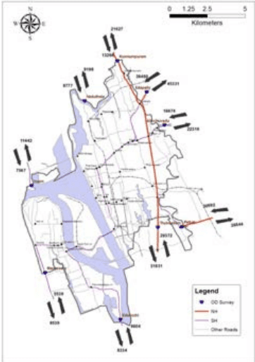
Figure-8:12 Inbound and outbound traffic in PCU at outer cordon locations Source: NATPAC study report, 2019
Kochi Municipal Corporation
TRANSPORTATION
8.4.1.2 Zoning Pattern adopted for the study
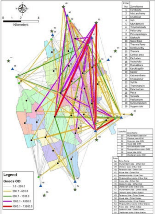
The study area and the surrounding regions were divided into traffic zones for spatial distribution of traffic within the study region. The Kochi Corporation area has been divided into 29 internal zones corresponding to the one or more wards of the city. The area outside the Corporation limits has been divided into 26 outer zones. The zoning of outside city has followed survey location wise intra district, inter district and interstate regions. Accordingly, first nine zones are intra district, next eight zones are outside Ernakulam district but within Kerala State and the rest are outside State. The zoning pattern would help to identify the traffic distribution within the district, inter-district and inter-state movement.
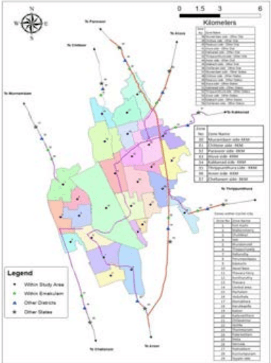
Figure 8:13 Zoning Pattern adopted for the study in Kochi City Source: NATPAC study report, 2019