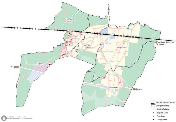
Kedgaon is located between Pune-Solapur Highway and the Pune-Daund Railway route. This provides a perfect setting for developing it into a “Commuter Town”, leveraging its potential for a railhead town. It is also a mid-town located over SH-118, connecting Shirur to Satara.
Promoting commercial development along the railway station to maximise the economic potential of railway land.
Maximise the economic potential of available government-owned land of 182 ha.
Effect of a bypass to SH 118 at Boripardhi village, avoiding the congestion alongside the railway station.
Increase residential zone with amenities at Kedgaon station, Kedgaon, Boripardhi and Dhaygudewadi to promote the work-live concept
Promote consolidated industrial clusters along the Pune- Solapur Highway.
Establish green-blue links by connecting forest and streams
Town Centre at Kedgaon.
Affordable housing, sports complex and cultural centre at Kedgaon.
Truck terminal at Kedgaon.
37.4Proposed Reservation Statement, Costing and Phasing
Table 37.10Proposed Reservation Statement
No
Purpose of Reservation
Planning Standard
Planning Standard
Total Re-quirement
Total Re-quirement
Existing/ Available
Existing/ Available
Proposed Reservations
Proposed Reservations
Total Reser-vations
Total Reser-vations
Area (Ha.)
Min unit re-quired
No of sites
Area in Ha
No of sites
Area in Ha
No of sites
Area in Ha
No of sites
Area in Ha
1
Primary School (I-V)*
0.4
1/5000 ppl, 1/500 students,
9
3.7
12
11.81
0
0
12
11.81
2
Secondary School (VI-XII)*
1
1/7500 ppl, 1/1000 students
6
11.11
5
10
0
0
5
10
3
Health Centre
0.08-0.12
1/15000 ppl
3
0.371
6
1.62
2
0.3
8
1.92
4
Community Hall
0.2
1/15000 ppl
3
2.22
0
0
1
0.5
1
0.5
5
Garden
1
1/15000 ppl
3
3.08
0
0
2
2.22
2
2.22
6
Playground
1.5
1/15000 ppl
3
4.63
0
0
5
5
5
5
7
Shopping Centre/Market
0.3-0.45
1/15000 ppl
3
1.421
1
2.39
1
0.5
2
2.89
Town Level
Town Level
Town Level
Town Level
Town Level
Town Level
Town Level
Town Level
Town Level
Town Level
Town Level
Town Level
1
College
5
1/1.25 lac ppl,
0
0
6
16.15
0
0
6
16.15
2
Hospital
1
1/ 1 lac ppl,
0
0
1
0.4
0
0
1
0.4
3
Residential
0
0
0
5
21.2
5
21.2
4
Socio-Cultural Centre
0.6-1
1/1lac,
0
0
0
0
1
1.3
1
1.3
5
Town Park
3-5
1/1lac,
0
0
0
0
1
3
1
3
6
Sports Complex
3-5
1/1lac,
0
0
0
1
4.24
1
4.24
7
Multipurpose Ground
1/1lac,
0
0
0
1
2.1
1
2.1
8
Burial Ground
4
1/5 lac,
0
0
1
3.54
0
0
1
3.54
9
Cremation Ground
2.5
1/5 lac,
0
0
5
0.71
1
0.91
6
1.62
10
Fire Brigade Station
0.4
1
0.4
1
0.38
1
0.38
11
Solid Waste Management Site
5 Ha . (As per land availability)
0
0
0
0
1
6.3
1
6.3
12
Sewerage Treat-ment Plant
80% of water supply may be expected to reach the sewers
Land area requirement is as per URDPFI i.e. For activated Sludge Process (ASP)-0.15 Ha/MLD
0
0
0
0
2
2.65
2
2.65
No
Purpose of Reservation
Planning Standard
Planning Standard
Total Re-quirement
Total Re-quirement
Existing/ Available
Existing/ Available
Proposed Reservations
Proposed Reservations
Total Reser-vations
Total Reser-vations
Area (Ha.)
Min unit re-quired
No of sites
Area in Ha
No of sites
Area in Ha
No of sites
Area in Ha
No of sites
Area in Ha
13
Water Works (Water Treatment Plant, Tanks and Pipes)
Land area requirement is as per URDPFI i.e. 1) 5MLD-0.10 Ha 2) 10MLD-0.19Ha 3) 50MLD-0.93 Ha 4) 100MLD-1.87Ha 5) 200MLD-3.73Ha 6) 500MLD-9.34Ha
Water require-ment of PMR is 72 lpcd as per Report 'Integrat-ed Master Plan Of Water Supply, Sewerage, Storm Water and Solid Waste Management in the PMR'. It is distributed to each Growth center.
0
0
0
0
1
0.25
1
0.25
14
Effluent Treatment Plant
-
-
0
0
0
0
0
0
0
0
15
Police Station
As per Government Authority requirement
0
0
0
0
1
1.2
1
1.2
16
District Court
0
0
0
0
1
2.7
1
2.7
Regional level
Regional level
Regional level
Regional level
Regional level
Regional level
Regional level
Regional level
Regional level
Regional level
Regional level
Regional level
1
Regional Centre
14 Ha. (As per concept plan)
2
Regional Park
0
0
0
0
3
Town Centre
0
0
0
0
1
5.8
1
5.8
4
Authority Purpose
0
0
0
0
3
12.4
3
12.4
5
Medical College & Hospital
15 Ha
1/10 lac
0
0
0
0
1
9.8
1
9.8
Transport
Transport
Transport
Transport
Transport
Transport
Transport
Transport
Transport
Transport
Transport
Transport
1
Bus Stand
As per Government Authority requirement
0
0
0
0
1
0.74
1
0.74
2
Truck Terminal
0
0
0
0
1
5.01
1
5.01
35
72
Chapter 37: Growth Centre: Kedgaon
Table 37.11Cost and Acquisition Statement for Proposed Reservations
Res-er-va-tion_No
Purpose of Reservation
Taluka
Village Name
S. No/ Gut No./ CTS No./F.P.No
Area (ha)
Land Ownership(Govt/GP/PMRDA/Private)
Total Cost of Acqui-sition (IN Cr.)
Total Cost of Devel-opment (Const.) (INR Cr)
Total Cost (INR Cr.)
Appro-priate Authority
1
Truck Terminal
Daund
Kedgaon
11
5.02
Government
0
31.27
31.27
PMRDA
2
Water Treat-ment Plant
Daund
Kedgaon
11P
0.25
Government
0
0
0
PMRDA/Govern-ment
3
Medical College & Hospital
Daund
Kedgaon
1P
9.83
Government
0
244.77
244.77
PMRDA
4
Fire Brigade Station
Daund
Kedgaon
1P
0.39
Government
0
10.97
10.97
PMRDA
5
Public Housing
Daund
Kedgaon
1P
6.83
Government
0
192.64
192.64
PMRDA
6
Police Station
Daund
Kedgaon
1P
1.23
Government
0
142.02
142.02
Police Depart-ment
7
Authority Purpose
Daund
Kedgaon
1P
6.30
Government
0
118.82
118.82
PMRDA
8
Solid Waste Management Site
Daund
Kedgaon
1P
6.30
Government
0
118.82
118.82
PMRDA/ZP
9
Town Park
Daund
Kedgaon
1P,118P
3.05
Government
0
18.95
18.95
PMRDA
10
Socio-Cultural Centre
Daund
Kedgaon
118P
1.30
Government
0
91.25
91.25
Table 37.12Phase-wise Programme
Purpose of Reservation
Phase I (Res-ervation No)
Phase II (Res-ervation No)
Phase III (Reservation No)
Phase IV (Reservation No)
Phase V (Res-ervation No)
Neighbourhood level
1
Primary School (I-V)*
2
Secondary School (VI-XII)*
3
Health Centre
24
27
4
Community Hall
32
5
Garden
25
29
6
Playground
30
23,34
28
26
7
Shopping Centre/ Market
22
Town Level
Chapter 37: Growth Centre: Kedgaon
Purpose of Reservation
Phase I (Reservation No)
Phase II (Reservation No)
Phase III (Reservation No)
Phase IV (Reservation No)
Phase V (Reservation No)
1
College
2
Hospital
3
3
Residential
4
Socio-Cultural Centre
10
5
Social Welfare Centre
13
6
Town Park
9
7
Sports Complex
15
8
Burial Ground
9
Cremation Ground
16
10
Fire Brigade Station
4
11
Solid Waste Management Site
8
7
12
Sewerage Treatment Plant
35
19
13
Water Works (Water Treatment Plant, Tanks and Pipes)
2
14
Effluent Treatment Plant
15
Multipurpose Ground
12
16
Public Housing
5,11
17
31
17
Town Centre
18
18
Authority Purpose
7
14,20
19
Police Station
6
20
Truck Terminal
1
21
Bus Stop
33
22
District Court
21
1
Regional Centre
2
Regional Park
3
Hospital & Medical College
Total Cost of development of Reservations of UGC : Kedgaon
Total Acquisition cost of Reservations ( in Rs.CR.)
Total Construction cost of Reservations ( in Rs.CR.)
Total Cost of development of Reservations( in Rs.CR.)
Road construction cost
Total Development Cost
Reservation on Amenity Space/TP scheme/Government (A)
0.00
1703.70
1703.70
881.21
2622.32
Reservations on Private land
1.53
73.28
74.81
50% of the total cost of reservations on private land with an assumption that 50% of reservations will be developed through TDR/AR & In-situ FSI (B)
0.77
36.64
37.41
Total Cost (A+B)
0.77
1740.34
1741.11
Chapter 38: Rural Growth Centres
The Rural Growth Centre concept is proposed in the Regional Plan 1997. It implies reducing the dependence of rural areas on urban areas by providing higher-order amenities at the most prominent/ accessible village within its rural catchment.
Rural planning strategies are shaped by the rural growth centre concept where the planning intent is to:
Make rural areas self-reliant for amenities & employment;
Improve the quality of living for rural residents by providing amenities within reach;
Avoid rural-urban trips to reduce congestion of Urban Areas;
Thus, the objective is to chart out the growth trajectory for the self-reliant rural area without succumbing to the vicious circle of urbanisation.
To facilitate the planning of the rural areas, rural settlements are organised into a hierarchy of two tiers as below and planning norms are proposed for each tier.
Rural Growth Centre
Village
PMRDA
11
Public Housing
Daund
Kedgaon
1P
4.13
Government
0
116.51
116.51
PMRDA
12
Multipurpose Ground
Daund
Kedgaon
118P
2.10
Government
0
4.25
4.25
PMRDA
13
Social Welfare Centre
Daund
Kedgaon
118P
2.00
Government
0
91.25
91.25
PMRDA
14
Authority Purpose
Daund
Kedgaon
118P
4.39
Government
0
82.75
82.75
PMRDA
15
Sports Complex
Daund
Kedgaon
118P
4.24
Government
0
79.99
79.99
PMRDA
16
Cremation Ground
Daund
Kedgaon
118P
0.91
Government
0
3.80
3.80
PMRDA
17
Public Housing
Daund
Kedgaon
118P
3.84
Government
0
185.23
185.23
PMRDA
18
Town Centre
Daund
Kedgaon
118P
5.86
Government
0
12.07
12.07
District and Session Court
19
Sewage Treatment Plant
Daund
Kedgaon
118P
1.71
Government
0
32.22
32.22
MHADA
20
Authority Purpose
Daund
Kedgaon
118P
1.71
Government
0.00
32.22
32.22
PMRDA
21
District Court
Daund
Kedgaon
1P
2.77
Government
0.00
64.58
64.58
PMRDA
22
Shopping Centre
Daund
Bori-pardhi
3
0.50
Private
91.89
12.05
103.94
PMRDA
23
Play ground
Daund
Bori-pardhi
3P(P)
1.64
Private
302.12
3.14
305.26
PMRDA
24
Health Centre
Daund
Bori-pardhi
117P(P)
0.17
Private
30.98
4.35
35.32
PMRDA
25
Garden
Daund
Bori-pardhi
154P(P)
1.02
Private
187.61
2.96
190.57
PMRDA
26
Play ground
Daund
Bori-pardhi
155P
0.62
Private
114.43
2.32
116.75
PMRDA
27
Health Centre
Daund
Bori-pardhi
258P
0.12
Private
17.03
3.67
20.70
PMRDA
28
Play ground
Daund
Bori-pardhi
238P
0.65
Private
87.41
2.32
89.73
PMRDA
29
Garden
Daund
Dhaya-gudewa-di
152P,151P
1.21
Private
220.35
3.51
223.86
PMRDA
30
Play ground
Daund
Dhay-gudewa-di
141P
0.62
Government
0.00
1.19
1.19
PMRDA
31
Public Housing
Daund
Dhay-gudewa-di
141P
6.41
Government
0.00
185.23
185.23
PMPML
32
Community Hall
Daund
Dhay-gudewa-di
141P
0.49
Government
0.00
14.38
14.38
PMRDA
33
Bus Stand
Daund
Dhay-gudewa-di
138P
0.75
Govern-ment(1HA)+Private(0.4)
0.00
10.84
10.84
PMRDA
34
Play ground
Daund
Dhaya-gudewa-di
176P
1.46
Private
304.31
2.95
307.26
PMRDA
35
Sewage Treatment Plant
Daund
Dhay-gudewa-di
120P
0.94
Private
171.82
0.00
171.82
PMRDA
37.2Existing Situation Analysis
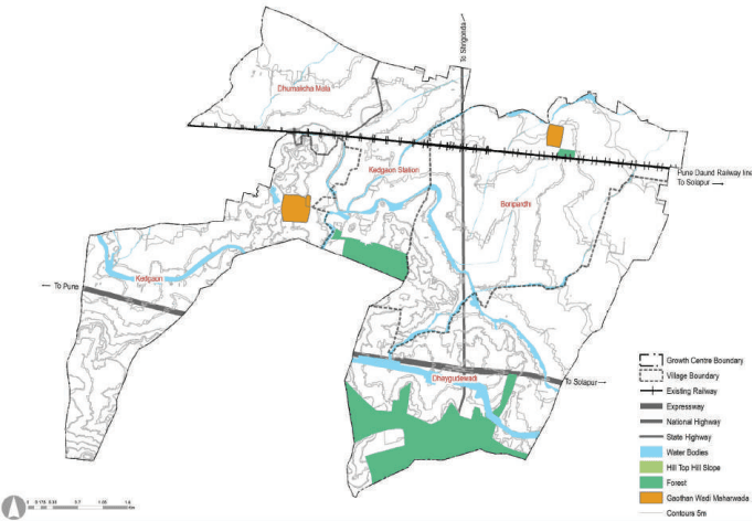
Kedgaon Growth Centre consists of five villages namely, Kedgaon, Kedgaon Station, Dhumalichamala, Boripardhi and Dhaygudewadi, all falling under Daund Taluka. The total area of Kedgaon GC is 2799.85 ha. According to Census 2011, Kedgaon Growth Centre population was 25,009 in 2011, and the estimated population for 2018 is 35,652.
Kedgaon Growth Centre’s key strength is it being a rail-head town along the Pune-Daund rail route, and it has good regional connectivity via NH-65 and SH-118.
Kedgaon GC is situated on the eastern side of PMR, 63 km from Pune city. Kedgaon is surrounded by Daund Taluka towards the east, Shirur Taluka towards the north, Yavat Growth Centre towards the west and Baramati Taluka towards the south-east.
Three major roads passing through the GC are Pune-Solapur Highway (NH-65), Shirur-Satara Highway (SH-118) and MDR-98.
Kedgaon has plain topography with a minimal area under the hilltop hill slope. No village in Kedgaon falls under the category of the Western Ghats. Most of the settlements of Kedgaon are situated along the railway line and highways with linear development.
Figure 37.1: Location and Physiography
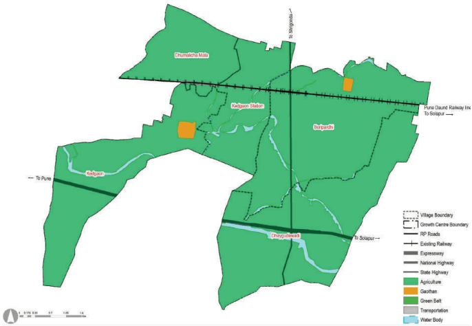
Regional Plan 1997 Analysis
This Growth Centre was not part of any urban sector of RP 1997. The entire area was proposed for agricultural activities.
Table 37.1Regional Plan 1997 Zone Area Statement
Land use category
Area (ha)
Proportion of Total Developed Area (%)
Proportion of Total Area (%)
Residential
20.47
72.82
0.73
Commercial
0
0.00
0.00
Industrial
0
0.00
0.00
Public and semi public
0
0.00
0.00
Garden, Playground and Recreation
0.00
0.00
Public Utility
0
0.00
0.00
Chapter 37: Growth Centre: Kedgaon
Transportation
7.64
27.17
0.27
Defense
0
0.00
0.00
Total Developed Area
28.11
Agriculture
2666.93
96.22
95.25
Water bodies
104.82
3.78
3.74
Green Belt
0
0.00
0.00
Hill_Top_Hill_Slope
0
0.00
0.00
Forest
0
0.00
0.00
Total Undeveloped Area
2771.75
Total Area
2799.86
Figure 37.2: RP 1997 Zoning Map
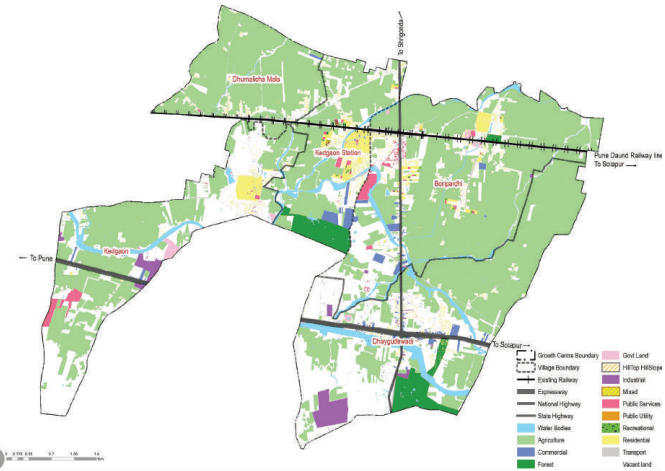
Existing Land Use
The most dominant land use in Kedgaon Growth Centre is Agriculture, which covers 1,510 hectares. There is minimal residential development currently in this Growth Centre. Brick-kilns are found along the highways with few dotted industrial developments.
Figure 37.3: Existing Land Use Map
Table 37.2Existing Land Use Area Statement
Land use category
Area (ha)
Proportion of Total Developed Area (%)
Proportion of Total Area (%)
Residential
67.98
22.51
0.82
Commercial
28.92
9.58
1.05
Industrial
38.4
12.72
1.40
Public and semi public
127.39
42.18
4.65
Garden, Playground and Recreation
2.91
0.96
0.11
Special Area
1.63
0.54
0.06
Public Utility
0.93
0.31
0.03
Transportation
35.45
11.74
1.29
Defense
0
0.00
0.00
Total Developed Area
301.98
Agriculture
1568.13
55.08
Water bodies
113
4.12
Vacant Land*
665.41
24.27
QUARRY
0
0.00
Chapter 37: Growth Centre: Kedgaon
Forest
151.34
5.52
Hill Top Hill Slope
0
0.00
Total Undeveloped Area
2439.87
98.40
Total Area
2799.86
Traffic congestions along the MDR-98 crossing a railway station
Critical junctions: NH-65 and SH-118 junction
Scattered development in Kedgaon Station
Absence of sewerage, stormwater drainage and solid waste management sites
37.3Proposed Role and Strategies
Kedgaon is envisioned to be developed as ‘Commuter Hub’, and the key reasons for this are as follows:
Strong regional connectivity realised through its location between Pune-Solapur Highway and Pune-Daund Railway Route
Leverage upon its potential of a railhead town
Potential for residential development along the railway corridor, improving the railway ridership and cross-subsidise railway station development
Development of amenities, serving not only the GC but surrounding rural area, arresting the urban-rural migration.
Protection of irrigation command area through compact development
Increase in demand for the standard of living through the development of social infrastructure
Understanding the above, three new-towns, i.e. three new nodes, are proposed at Kedgaon Station, Boripardhi and Dhayagude Wadi with a balanced distribution of amenities and infrastructure. A good quality living with accessibility to social infrastructure will enable its transformation into a ‘Commuter Town.’
Based on the URGD method, the projected population for the Growth Center is presented in Table 37.3.
Table 37.3Population Projections
Village
2011
2018
2031
2041
Boripardhi
13,415
16807
20794
23316
Dhaygudewadi
-
700
1000
1000
Dhumalicha Mala
1,748
2465
2976
3183
Kedgaon
3,492
4102
4844
5327
Kedgaon Station
6,354
11578
16709
19858
Total
19,769
35652
46323
52684
The projected employment (URGD method) for the Growth Centre for the year 2041 is 52,684 whereas the proposed residential density is about 150 PPH (15,000 persons/sq km).
Kedgaon Growth Center is proposed with only one sector as the projected population for the year 2041 is only 52,684. The projected sector-wise population statement is in Table 37.4.
Table 37.4Projected Population - Sectors
Sector
2011
2018
2031
2041
Sector 1
19,769
35652
46323
52684
Total
19,769
35652
46323
52684
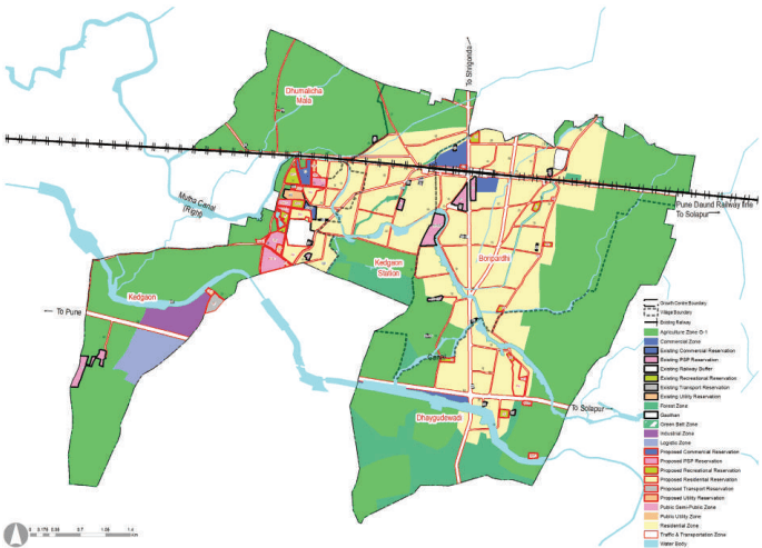
The proposed zoning would guide and determine the optimal and efficient land use for the next 20 years. The proposed zoning plan is an output of existing land use and physical conditions analysis, understanding of most pressing issues of the Growth Center, local knowledge of the place and deployment of five planning goals and allied physical planning strategies. The proposed zoning area statement is presented in Table 37.5.
Figure 37.4: Proposed Zoning Map
Table 37.5Proposed Zoning Area Statement
Land use category
Area (ha)
Proportion of Total De-veloped Area (%)
Proportion of Total Area(%)
Residential
703.28
65.76
25.12
Gaothan
18.19
1.70
0.65
Commercial
32.75
3.06
1.17
Industrial
33.05
3.09
1.18
Chapter 37: Growth Centre: Kedgaon
Logistics
39.38
3.68
1.14
Tourism Development
0
0
0
Public and semi public
48.92
4.57
1.75
Public Utility
9.86
0.92
0.35
Traffic & Transportation
183.98
17.20
6.57
Defense
0
0
0
Total Developed Area
1069.41
100
Agriculture (G1)
1443.19
51.55
Water bodies
46.36
1.66
Green Belt
62.19
2.22
Forest
163.07
5.82
Hilltop Hillslope
0
0
Regional Park
0
0
Recreational
0
0.56
Quarry
0
0
Afforestation
15.54
0
Total Non-Developable Area
1730.35
Total
2799.85
Translating Goals into the Plan
Proposed zoning ensures that the sectoral development goals are clearly conveyed through it. Proposed sectoral goals and their corresponding physical planning strategies are mentioned in Table 37.5.
Table 37.6Goals and Physical Planning Strategies
Goals
Development Sector Addressed
Physical Planning Strategies
Prudent
Employment and housing
Work- Live Hubs
Convenient
Roads and mass transport
Movement Lattice
Resilient
Environment protection
Green- Blue connectors
Efficient
Infrastructure and utilities
Decentralized resource management
Self- sufficient
Social facilities
Walkable Neighbourhoods
For Kedgaon Growth Center, the Work-Live concept is applied by:
Designating residential zones within 500 m around existing railway stations and town centre to minimize work-related trips for at least 30% of the resident workforce
Allocating 103 ha new industrial and commercial zones along the highways to reduce travel time for commuting within the Growth Centre and to and fro from other Growth Centres
Town Centre is proposed at Kedgaon Station, at a central location within the Growth Centre.
Out of the total industrial zone of 188.5 sq km proposed for the Study Area, based on 50 workers/ha, 1 sq km of industrial development is envisaged at Kedgaon Growth Centre.
The industrial zone as per ELU was 38.4 ha, whereas RP 1997 did not reserve lands for industrial use in the Growth Centre. Considering the existing industrial development scenario, strategic infrastructure proposals within the Growth Centre and the planning intent of RP 1997, industrial use over an area of 33.06 ha is proposed in Kedgaon Growth Centre.
The planning intent is to initiate industrial development along national and state highways in the GC in a consolidated manner. It is also connected to a rural catchment utilizing MDR/SH and village roads to support the agriculture sector. This industrial zone would be directly accessible from the bus terminal proposed within the industrial area along the NH-65.
The total logistic land use requirement of the Study Area is estimated to be 20.2 sq km considering projected demographics and area requirement of 55 sqm built-up area per person. 1 sq km of this estimated area is anticipated in Kedgaon Growth Centre. However, considering the proposed role of the GC, the prevailing trend of warehousing and supplementary industries and the proposed strategic infrastructure projects, logistic use is proposed over 39.39 sq km.
Land requirement for residential use is estimated based on a net residential density of 125 PPH. Considering 45% top-up (15% amenity, 10% open spaces and 20% roads), the gross area required for the projected population of 52,684 in Kedgaon Growth Centre is estimated to be 7 sq km.
Considering existing mature settlements at Kedgaon Station, Boripardhi and Dhayagudewadi, these residential nodes are expanded to accommodate the future population. With the above mentioned projected higher density, around 186 ha is proposed around Kedgaon Station while 7.51 ha is proposed around Dhumalichamal. A new residential node with 32.75 ha of the area is introduced at Boripardhi, aligning the SH-118.
Three commercial nodes are proposed at Kedgaon Station, Boripardhi and Dhayagude Wadi. Brick kiln and logistic activities are observed at Dhayagude Wadi. Thus the commercial zone is proposed supporting the service industry activities complementing industrial development. In contrast, the commercial zone at Kedgaon Station is proposed to encourage the hospitality and logistic sector development supporting railway station activity. Land requirement for the commercial zone is estimated based on URDPFI guidelines, i.e. 0.4 ha per 1,000 population and topping up 30% (15% road, 10% open space, 5% amenity). The total commercial zone works out to be 0.24 sq km, while the proposed 0.26 sq km commercial zone area aligns with the guidelines.
The movement lattice concept also includes a mass transit corridor running through the Growth Center centre, high-speed rail crossing the Centre and Ring Road to encourage >50% of the residents to use mass transport for their daily commute.
Chapter 37: Growth Centre: Kedgaon
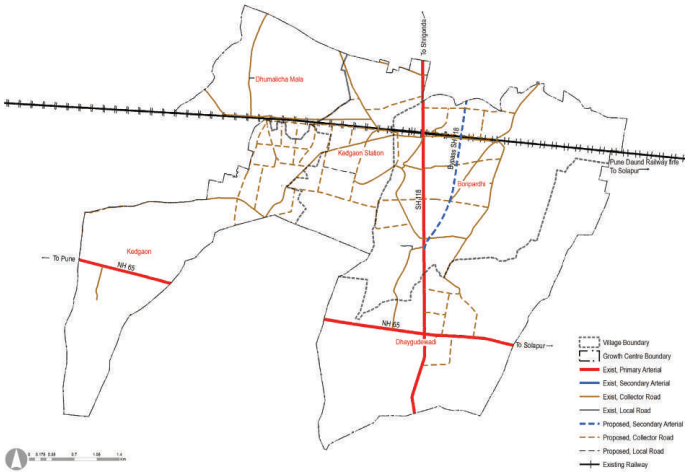
A parallel system (24 m road) to SH-118 is proposed on its eastern side, bypassing the congested section starting Boripardhi until Dhaygudewadi.
An alternate route to MDR-98 crossing Kedgaon Station is proposed on the north of the station connecting SH-68, SH-118 to the proposed Town Centre.
A radial grid of collector roads (15-24 m wide) is proposed at Boripardhi.
Collector roads (15-24 m wide) follow spacing of 300-500 m, which Secondary arterial (30-45 m wide) follow a grid of 1 to 2 km.
Secondary arterials have the flexibility to run a dedicated bus service for faster transport and support the feeder system and last-mile connectivity.
All existing roads to be redeveloped and proposed roads are to be designated with at least 3m wide footpath on either side of the road, as the ‘pedestrian right of way’ and ‘hawker-free zone.’
Figure 37.5: Proposed Transport Network Map
Table 37.7Proposed Transport Network Statement
Road Category
Road names/ ROWs
Proposed ROWs Authority
Total Length Cost of Road (km) development
Primary
NH65
60
NHAI
4.45
Secondary
SH118
45
PWD
5.51
Tertiary
MDR118MDR95MDR82MDR98
24242424
PWD PWD PWD PWD
3.630.5470.075.297
Local
VR (Total)
15
ZP
7.3
DP Roads
Primary
MSRDC Ring Road
110
MSRDC
0
0
Expressway
90
MSRTC
0
0
PMRDA Ring Road
65
PMRDA
0
0
Secondary
45
PMRDA
0
0
30
PMRDA
0
0
Tertiary
24
PMRDA
2.24
30.5228609
18
PMRDA
9.33
95.289228
15
PMRDA
36.32
124.1324797
Local
12
PMRDA
0.9
6.2051376
Total Road Length
75.58
All existing streams to be protected
These protected Green-Blue features are recommended to be connected by a 30-45m wide secondary arterial road that would be upgraded as a tree-lined avenue by developing NMT corridors (>3 m each) on both sides of the road and segregated from footpaths.
Green lungs are proposed within 500 m walkable distance covering an area of 74.58 ha. These green lungs include active and passive recreational spaces. The total active recreational space works out to be 7.08 ha that include playgrounds, sport complex, stadium and multi-purpose ground. And the total passive recreational space works out to be 67.49 ha that include gardens, town park/ regional park, bio diversity park and green belt.
3 Sewerage Treatment Plants are proposed at Kedgaon(0.76 ha) and Dhaygudewadi(0.94 ha.) and at Kedgaon.
Renewable energy sites could be proposed and are recommended in areas with high elevation. However, they would be finalised after a detailed study.
Chapter 37: Growth Centre: Kedgaon
Currently, 4 cremation grounds and 1 burial ground are present in the Growth Centre. Thus no new additions are proposed.
Fire brigade station is proposed on government land at Kedgaon along MDR-98
1 Solid Waste Mangenment Site is proposed at Kedgaon.
Table 37.8Proposed Infrastructure Demand
Infrastructure Sys-tem
Demand (2041)
Unit
Utility Sites
Total Area (Ha)
Water Supply
3.82
MLD
0 WTPs
0
Sewerage
3.79
MLD
3 STPs
2.58
Solid Waste
15.81
Tones/day
1 SWM
0.80
Self-sufficient: Walkable Neighbourhoods
This goal is set to increase the liability index of the Growth Centre. To do that, amenities are proposed within 500 m distance, leveraging the concept of Walkable Neighbourhoods. The concept entails providing basic infrastructure and services for education, health, sports, and recreation within the neighbourhood to have easy access to them by foot.
Amenity provision is made for the projected population by 2031 (46,323 people)
Neighbourhood level amenities are located within a 500 m radius from residential zones and are connected by collector/local roads to improve their accessibility from other neighbourhoods.
81.13 ha of government land is present in Kedgaon. The government land is well planned providing good quality plots and access to the majority of public amenities.
Education: The existing number of schools in the Growth Centre is more than sufficient to serve the projected population. Thus, no new schools are proposed.
Health: Health Centres are provided considering walking radius within a Neighbourhood. 2 health centres are proposed at Boripardhi. A medical college and hospital (9.8 ha) is proposed at Kedgaon village.
Socio-Cultural: One community hall is provided at Dhaygudewadi considering walking distance within a neighbourhood. A sociocultural centre and socio-welfare centre is proposed at Kedgaon on government land
Open Space: 5 playgrounds are proposed, 3 at Boripardhi and two at Dhaygudewadi. 2 neighbourhood gardens are proposed, one at Dhaygudewadi and another at Boripardhi. Town Parks is provided along/near pons over government-owned land. Sports Complex is provided adjoining to the town centre, in order to serve the surrounding rural areas.
Commercial: Shopping Centre is provided at Boripardhi. Town Centre over an area of 5.97 ha is proposed on government land along Pune- Daund railway line, adjacent to the sports complex.
Residential: 3 Public housing projects are proposed at Kedagaon adjacent to Gaothan over the government land. Also public housing is proposed at Dhaygudeadi.
• Transport: A bus stand is proposed on NH-65, while a truck terminal is proposed at Kedgaon.
Civic facilities requested by various government authorities: District court is proposed over the government land in Kedgaon as per the requirement of District and Session court, Pune. Police station is provided adjacent to Kedgaon gaothan as per requirement of Superintendent of Police, Pune (Rural)
Table 37.9Summary of Land Ownership of Proposed Amenities
Land Ownership
No of Amenity
Total Area (ha)
Government Land
24
66.04
Private Land
10
8.33
Amenity Space
0
0
Other
1
0.74
Total
35
75.11
Implementation Strategy for the Proposed Reservations
The proposals/reservations of the Development Plan are proposed to be acquired and developed through the mechanism of Accommodation of Reservation and Transfer of Development Rights (TDR) policy. It is estimated that all proposed roads and 50% of the public reservations will be acquired through TDR/FSI/AR. Remaining
The remaining reservations will be acquired under the provision of the Land Acquisition Act by paying monetary compensation.