Loni Kalbhor Growth Centre is envisioned to be developed as ‘Life Sciences and Smart Agriculture Hub’. The primary reason to assign this economic role to Loni Kalbhor is to leverage prevailing biopharma activities in this area with the presence of a strong pharmaceutical ecosystem, renowned organisations such as Serum Institute of India, robust institutional base and significant area falling under irrigation command area along with sustainable agriculture practices in the area. It also enjoys a locational advantage due to its proximity to the proposed Chhatrapati Sambhaji Raje International Airport at Purandar.
Develop a Life Sciences Corridor to foster activities such as Biotechnology, Pharmaceutical, Healthcare Devices through the development of Town Planning Scheme at Manjari Kh.
Promote logistic and warehousing activities by consolidating cluster development leveraging existing high demand along the Pune-Saswad Road and capitalising on the metro corridor (Hadapsar-CSR International Airport)
Promote Work-Live hub concept by increasing residential development adjacent to existing industrial activities.
Develop bypasses to primary roads for avoiding congestion due to logistic, commercial activities.
Develop a grid network of secondary and tertiary roads for a smooth movement within the Growth Centre.
Develop facilities complementing the Palakhi activities along Pune-Saswad State Highway and Pune-Solapur National Highway.
Develop a parallel road system to Ring Road helping modulate the traffic.
Develop a multi-modal hub to facilitate smoother movement across Metro, High-Speed Rail, and existing railway.
Protect all the natural streams in the Growth Centre.
Establish green-blue links by connecting streams, forest and green belt Mula-Mutha River.
Promote self-sufficient town by proposing required amenities and utilities for the projected population.
Town Planning Scheme at Manjari Khurd themed as Life Sciences Park
Town Planning Scheme at Vadki themed as Logistic Park to support food processing and other industries
Town Planning Scheme of Manjari Kh-Kolavadi, Holkarwadi, Autade-Handewadi and Wadachiwadi for
development of 17.7 km of Ring Road
Logistic Park at Vadki along NH 965 and Airport Metro
Cultural Centres at Loni Kalbhor and Vadki adjoining Palakhi Sthal
Town Centre at Kadamwak Wasti
Multimodal Hub at Manjari Bk
High-Speed Rail and its station at Manjari Bk
Airport Metro line (Hadapsar-Loni Kalbhor and Hadapsar-New Airport)
Metro Depot at Loni Kalbhor
Town Park and Bird Watching Centre along Mula-Mutha river in Manjari Bk
Town Park along Mastani Talav
Sports Complex at Vadki
Renewable Energy Park at Holkarwadi
30 m wide road Vadki-Manjari-Awhalwadi
23.2Existing Situation Analysis
Loni Kalbhor Growth Center is in Haveli taluka and comprises 11 villages, namely, Shewalwadi, Manjari Bk, Manjari Kh., Kadamwak Wasti, Kolwadi, Loni- Kalbhor, Vadki, Wadachiwadi, Autad Handewadi, Pisoli and Holkarwadi. Its total area is 141.83 sq km. According to Census 2011, Loni Kalbhor Growth Centre population was 1,12,358, and the estimated population for 2018 is 174,693 with 74,277 employment.
Loni Kalbhor Growth Centre enjoys great locational advantage with its proximity to adjoining PMC developments and Pune-Solapur National Highway. Further, it enjoys strong regional connectivity through existing and proposed infrastructure developments such as Ring Road, national highway, state highways, new airport metro and highspeed rail project.
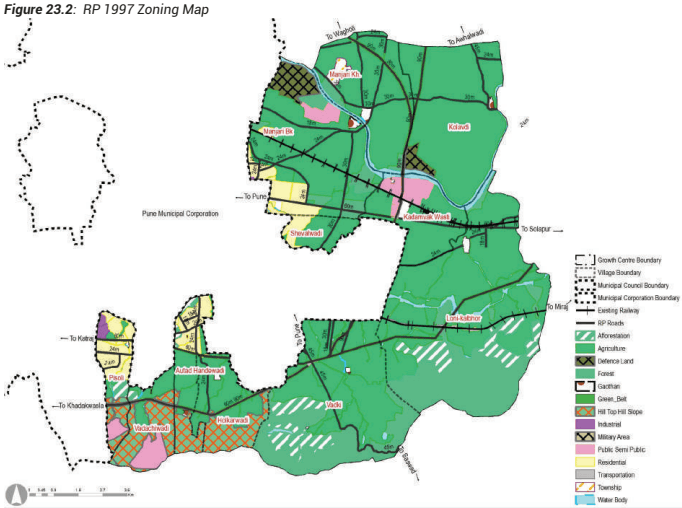
A portion of the GC was part of the RP 1997, falling under Sector G and PMR. RP 1997 recommended residential and industrial zones in the GC, attracting many planned layout developments in the area.
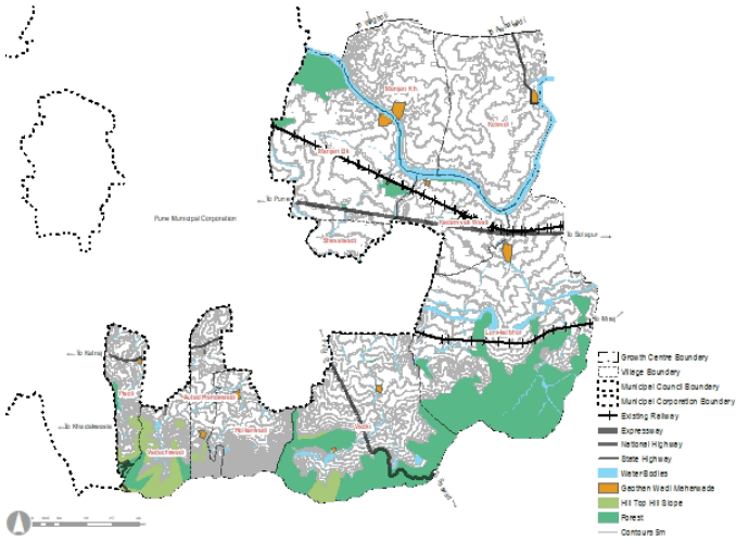
Loni-Kalbhor is located on the south-eastern side of PMC. It shares a boundary with PMC on its entire western edge. Loni Kalbhor is surrounded by Wagholi on the northern side, Uruli Kanchan on the eastern side, Saswad on the south-eastern side. Mula-Mutha River passes on the north side of Loni-Kalbhor. The southern tip of Loni-Kalbhor is a hilltop hillslope area, while the rest of the Growth Centre has plain terrain.
Loni Kalbhor is situated along the Pune-Solapur National Highway (NH-65) as well as Pune-Saswad NH-965 and NH-548DD. NH-548DD runs through the area connecting Katraj via Vadki to Pune- Solapur Highway further connecting northwards to Pune-Ahmednagar Road (NH-753F). NH-548DD connects the industrial developments of Katraj, Pisoli, Vadki, Loni Kalbhor, Lonikand and Markal. MDR-136 is a long connector road connecting Vadki to Ahwalwadi via Manjari. MDR-34 connects Hadapsar to Manjari Bk. Thus Loni Kalbhor GC is well connected to industrial developments within PMC and Lonikand/Markal, an agro-processing segment of Uruli Kanchan and further connected to the proposed CSR International Airport at Saswad. Two existing railway lines, i.e. Pune-Daund and Pune-Miraj pass through the GC, and the Railway administration has proposed to quadruple these routes.
The southern edge of the GC that includes Holkarwadi, Vadki, Pisoli, Wadachiwadi and Autade Handewadi are lined with steep slopes with 769 ha falling under the hilltop hill slope. Many streams, including revenue streams, run from these slopes towards Vadki, Fursungi, Uruli Devachi and Loni Kalbhor. These streams need to be protected. Forest land is located in Manjari Bk, abutting the Mula-Mutha river. The northern area of Manjari and Kolwadi has a gentle slope towards the river. Mutha right bank canal cuts across the GC, firstly through Shewalwadi and then passing through Loni Kalbhor.
Chapter 23: Growth Centre: Loni Kalbhor
Figure 23.1: Location and Physiography
Loni Kalbhor town was one of the four urban growth centres proposed in RP 1997, for which a separate Development Plan was sanctioned for Pune Zilla Parishad, while the remaining area of the Loni Kalbhor GC was included in Sector G and Sector PMR of the RP 1997. RP 1997 recommended revision of the Loni Kalbhor Development Plan for developing a township of 50,000 population.
Within Sector G of the RP 1997, residential zoning over 1,575 ha was proposed at Fursungi, Shewalwadi and Manjari Bk, approximately half of which falls in the GC. It also proposed industrial zoning over 118 ha at Hadapsar, Pisoli, Fursungi and Uruli Devachi, out of which 51 ha industrial area in Pisoli village is part of the GC.
In terms of transport planning, the Regional Plan proposed connectivity to Vadgaonsheri-Kharadi residential/ industrial area, Awhalwadi and Lonikand via a bridge over the Mula-Mutha river at Manjari Kh. A 90 m wide easterly diversion (Ring Road) was proposed connecting Vadki via Fursungi, crossing NH-65, to Pune-Ahmednagar Road (NH-753F). A 90m road was proposed connecting Vadki to Pune-Solapur Highway, which has now been proposed as NH-548 DD.
Table 23.1Regional Plan 1997 Land Use Area Statement
Land use category
Area (ha) Poproepdo Artrieoa
n of Total Devel- Proportio(%) (%)
n of Total Area
Residential
787.74
37.80
5.55
Commercial
10.63
0.51
0.07
Industrial
30.00
1.44
0.21
Public and semi public
373.19
17.91
2.63
Public Utility
6.29
0.30
0.04
Transportation
640.14
30.72
4.51
Defence
236.07
11.33
1.66
Total Developed Area
2084.06
100
14.69
Agriculture
8284.35
58.41
Water bodies
540.79
3.81
Forest
1832.58
12.92
Hill top Hill slope
770.40
5.43
Afforestation
670.89
4.73
Total Undeveloped Area
12099.01
85.30
Total Area
14183.07
100.00
Chapter 23: Growth Centre: Loni Kalbhor
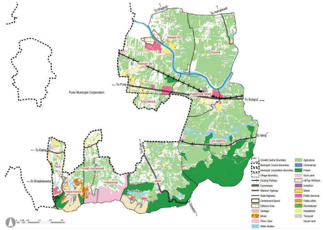
Areas such as Manjari, Shewalewadi, Vadki, Autade Handewadi and Pisoli have rapidly grown due to proximity with PMC, Kharadi IT Park, Lohegaon Airport and Shikrapur industrial area. However, most of the Growth Centre land is still under agricultural use (43.6%), with built-up areas concentrated around villages mentioned above.
The total area of Loni Kalbhor Growth Center is about 14,183.07 ha. As compared to agricultural land use (43.6%), residential and commercial areas are only 3.86% and 0.49%, respectively. This lower proportion of the development indicates underutilisation of the strategic location of the Growth Centre. Although the area under development is relatively small, this mixed-use development has dispersed across the area, especially within Manjari Bk and Shewalwadi area. HTHS and forest cover 3.89% and 12.78 % of the total land use. Public utilities contribute about 0.03% only of the existing land use.
This Growth Centre hosts the well-known Serum Institute of India, MIT University, Trinity College and Vasantdada Sugar Institute and area under agricultural research institutes and grape research academy. Hindustan Petroleum, along with its storage containers, occupies an area around the Loni Kalbhor railway station. Mastani Talav and bird watching destinations along Mula-Mutha bank are the major tourist attractions of the place. During the Wari proceedings, both Loni Kalbhor and Vadki transform their spaces into hosting the pilgrims. Ramdara Temple is another famous religious place located in a scenic location in Loni Kalbhor village.
Loni Kalbhor Development Plan
Loni Kalbhor development plan was sanctioned in 1975, which included the current Kadamwak Vasti and Loni Kalbhor villages. Government of Maharashatra in Urban Development Department had appointed (Pune Metropolitan Region Development Authority ) PMRDA as special planning authority under section 40 (1) (d) of the said Act vide Notification No.TPS-1817/CR173/2017UD -13 dated 18th January 2018 with retrospective effect from 31st March 2015 for notified area. PMRDA is the planning authority for this area now, and thus, this new Development Plan will supersede the previous plan. PMRDA had declared intention for preperation of Development plan of Loni Kalbhor and Kadamwak wasti on 20th November 2020.The Growth Centre has two integrated townships at Manjari Kh and Manjari Bk/Kadamwak Wasti and five proposed town planning schemes at Holkarwadi, Autade Handewadi, Wadachiwadi, Manjari Kh and Kolwadi as part of Ring Road implementation strategy. Three more Town Planning Schemes are under consideration, two near Vadki and one at Manjari Kh.
Figure 23.3: Existing Land use Map
Table 23.2Existing Land Use Area Statement
Land use category
Area (ha)
Proportion of Total Developed Area (%)
Proportion of Total Area(%)
Residential
547.08
26.49
3.86
Commercial
69.69
3.37
0.49
Industrial
71.81
3.48
0.51
Public and semi public
224.45
10.87
1.58
Garden, Playground and Recreation
9.68
0.47
0.07
Public Utility
4.06
0.20
0.03
Transportation
407.69
19.74
2.87
Defence
324.86
15.73
2.29
Mixed
6.00
0.29
0.04
Govt. Land
399.87
19.36
2.82
Total Developed Area
2065.19
100.00
14.56
Agriculture
6183.92
43.60
Water bodies
23.3Proposed Role and Strategies
Loni Kalbhor is positioned as a ‘Life Sciences and Smart Agriculture Hub’, and the key reasons for this are as follow:
Opportunity to leverage prevailing biopharma activities in this area with the presence of a robust pharmaceutical ecosystem and renowned organisations such as Serum Institute of India and strong institutional base
A significant area of the GC falls under the irrigation command zone with an opportunity to promote smart
Chapter 23: Growth Centre: Loni Kalbhor
and sustainable agriculture practices
Opportunity to foster the development of FMCG/Food Processing due to robust regional connectivity and proximity to the proposed CSR International Airport at Purandar and connectivity via Pune-Nashik High-Speed Rail Route
Considering the above, five distinct nodes are proposed in the GC - first at Manjari Bk., integrating residential and commercial development with Pune-Nashik High-Speed Railway station; second at Loni Kalbhor, integrating institutional and commercial hub with the existing railway station, proposed metro station; Third at junction of MDR 135 and 136 at Holkarwadi and Autad Handewadi forth at Shewal wadi, and the last at Vadki, promoting consolidate clustered development of logistic activities.
Loni Kalbhor Centre is proposed to be one of the major high-density residential Growth Centres. It is expected to host the finest institutional and commercial enterprises that would leverage its role as Life Science Hub.
Socio Economic Projections
Table 23.3Population Projections
Villages
2011
2018
2031
2041
Autadwadi Handewadi
2556
8196
39541
71535
Holkarwadi
2913
3332
99312
195140
Kadamwak Wasti
19239
28357
75648
125029
Kolwadi
4967
5587
6656
7504
Loni-kalbhor
22518
27948
33485
37867
Manjari Bk (N.V.)
36816
58395
69563
78380
Manjari Kh.
4559
7715
89658
171986
Pisoli (N.V.)
5417
15730
18555
20775
Shewalwadi
4059
7178
10320
13784
Wadachiwadi
929
1321
44572
88070
Vadki
8385
10935
17067
23640
Total
112358
174693
504376
833710
The projected resident workforce based on the projected population through the URGD method is 3,96,750. Considering the proposed economic activities of all the growth centres, employment distribution was proposed based on the envisaged sectoral split for that Growth Centres. Accordingly, the employment to be generated for the Growth Centre for the year 2041 is estimated to be 129,297. The proposed residential density is about 125 PPH (12,500 persons/sq km).
For the planning of public facilities distribution, Loni Kalbhor GC is divided into three sectors: Manjari Bk, Manjari Kh and Kolawadi form the northern sector Shewalwadi, Kadamwak Wasti and Loni Kalbhor together form the middle sector and Vadki, Holkarwadi, Autade Handewadi, Wadachiwadi and Pisoli make up the southern sector.
The boundaries of this planning division are shown on the Proposed Zoning Map. The projected sector-wise population statement is in Table 23.4.
Table 23.4Projected Population - Sectors
Sector
2011
2018
2031
2041
Sector 1
46,342
71697
165876
257870
Sector 2
45,816
63482
119453
176680
Sector 3
20,200
39513
219047
399160
Total
112,358
174693
504376
833710
Proposed Zoning
The proposed zoning would guide and determine the optimal and efficient land use for the next 20 years. The proposed zoning plan is an output of existing land use and physical conditions analysis, understanding of most pressing issues of the Growth Center, local knowledge of the place and deployment of five planning goals and allied physical planning strategies. The proposed zoning area statement is presented in Table 23.5.
Figure 23.4: Proposed Zoning Map
Table 23.5Proposed Zoning Area Statement
Land use category
Area (Ha.)
Proportion of Total Devel-oped Area (%)
Proportion of Total Area(%)
Residential
4180.91
60.49
29.48
Gaothan
44.88
0.65
0.32
Commercial
312.72
4.52
2.20
Chapter 23: Growth Centre: Loni Kalbhor
Industrial
279.65
4.05
1.97
Logistics
85.65
1.24
0.60
Public and semi public
490.27
7.09
3.46
Public Utility
36.26
0.52
0.26
Traffic & Transportation
1146.82
16.59
8.09
Defence
129.92
1.88
0.92
Recreational
163.14
2.36
1.15
Special Economic Zone
41.00
0.59
0.29
Total Developed Area
6911.22
100.00
48.73
Agriculture (G1)
3389.52
23.90
Water bodies
510.90
3.60
Green Belt
280.59
1.98
Forest
2062.09
14.54
Hilltop Hillslope
781.90
5.51
Ouarry
37.37
0.26
Afforestation
209.48
1.48
Total Non-Developable Area
7271.85
51.27
Total
14183.07
100.00
Translating Goals into the Plan
Proposed zoning ensures that the sectoral development goals are clearly conveyed through it. Proposed sectoral goals and their corresponding physical planning strategies are mentioned in Table 23.6.
Table 23.6Goals and Physical Planning Strategies
Goals
Development Sector Addressed
Physical Planning Strategies
Prudent
Employment and housing
Work- Live Hubs
Convenient
Roads and mass transport
Movement Lattice
Resilient
Environment protection
Green- Blue connectors
Efficient
Infrastructure and utilities
Decentralized resource management
Self- sufficient
Social facilities
Walkable Neighbourhoods
For Loni Kalbhor Growth Center, the Work-Live concept is applied by:
Designating residential zones within 500 m around industrial, logistics, commercial zones and town centre to
minimise work-related trips for at least 30% of the resident workforce
Expanding the existing logistic zones and commercial zones along PMRDA Ring Road and Pune Saswad State Highway junction to reduce travel time for the workforce to commute within the Growth Centre as well as to and fro other Growth Centers
Proposing Town Centre at Kadamwak Wasti adjoining the proposed Metro Depot, serving the matured settlement of Manjari, Kadamwak Wasti and Loni Kalbhor
Out of the total proposed industrial zone over 18660 ha, industrial use over 280 ha is envisaged in Loni Kalbhor Growth Centre, both based on projected employment and 50 workers/ha density.
The industrial zone as per ELU was 71.81 ha while 30 ha was proposed in RP 1997. Thus considering the existing scenario of industrial development, the strategic infrastructure proposals and planning intent of Regional Plan, 279.65 ha of industrial zone is proposed for general industrial activity
The Development Plan intent is to foster ‘Life Sciences activities’ as per the envisioned role, by proposing an industrial zone at Manjari Kh, that supports the existing pharma and biotechnology eco-system. This zone is strategically proposed around the intersection of PMRDA Ring Road and the Pune-Nashik high speed rail, which provides good connectivity. A town planning scheme is proposed encompassing this industrial zone, enabling its implementation and that of the Ring Road. The existing industrial activities around the Loni Kalbhor railway station and at Pisoli (based on RP 1997) are maintained.
The total logistic land use requirement of the Study Area is estimated to be 2020 ha considering projected demographics and area requirement of 55 sqm built-up area per person.50 ha of this estimated area is anticipated in Loni Kalbhor Growth Centre. However, considering the proposed role of the GC, the prevailing trend of warehousing and supplementary industries and the proposed strategic infrastructure projects, logistic use is proposed over 85.65 ha.
Currently logistic activities are observed north of the Ring Road at Vadki. These activities are supported by the Saswad Road railway station and NH 965, connecting Pune- Hadapsar- Saswad. With the proposal of Airport metro along the national highway, a logistic zone is proposed at southern part of Vadki along NH 965 that will enable the food processing, packaging and other industries, supporting the role. In order to implement Logistic Park/ activities, Town Planning Scheme is proposed encompassing this zone.
Land requirement for the residential zone is estimated based on a net residential density of 125 PPH. Further, 45% add-on is considered to account for amenity (15%), open spaces (10%) and roads (20%). The total population of ITP & TPS in the Growth Centre is 538,600, while the projected population for the rest of the Growth Centre area is 295,110. Accordingly, the total gross area required for the total projected GC population of 833,710, is estimated to be 4420 ha.
Considering the projected population, net residential density, proposed role and existing growth trends within the Growth Centre, 4180.91 ha of gross residential zone is proposed.
As per the Work Live hub concept, three distinctive residential sectors are proposed in the Growth Centre. Manjari Bk, Shewalwadi, Kadamwak Vasti and Loni Kalbhor are the areas where high density residential is observed. Understanding the existing matured residential development, current development trend, work hubs, multi-modal hub and infrastructure projects such as Ring Road, High Speed Rail, existing railway and metro, almost 2484 ha of residential zone is proposed in Sector 1 (Manjari Bk, Manjari Kh and Kolawadi). In its continuation, Shewalwadi, Loni Kalbhor, Kadamwak Vasti forming the second sector, 1237 ha of residential zone is proposed surrounding the existing Loni Kalbhor station, industrial, institutional, warehousing activities along the national highway while supporting the Town centre. Vadki, Autad Handewadi, Pisoli and four town planning schemes together form the third major residential areas of the Growth Centre. Two new Town Planning Schemes are proposed, each at Vadki and Manjari Kh.
Land requirement for the commercial zone is estimated based on URDPFI guidelines, i.e. 0.6 ha per 1,000
Chapter 23: Growth Centre: Loni Kalbhor
population. An additional 30% is considered to account for roads (15%), open spaces (10%) and amenities (5%). Accordingly, the total commercial zone requirement for the Study Area is estimated to be 2377 ha. 312.72 ha from this area is proposed in the Growth Centre such that equitable distribution of commercial activities is facilitated.
Commercial node at Manjari Bk is proposed to integrate with High Speed Rail Station and existing Railway Station on Pune- Daund railway line. Another major commercial development is proposed along Pune- Saswad NH 965 with Metro alignment, building upon the existing trend of warehousing and other allied services, strengthening the transit corridor. Third node is proposed along the National Highway at Kadamwak Vasti, leveraging on the existing commercial activities of the highway and that of the proposed Metro alignment, as well as complementing the logistic activities proposed north of Ring Road. Commercial zone proposed at Holkarwadi is for supporting convenient shopping and other neighbourhood needs.
The movement lattice concept also includes a mass transit corridor running through the Growth Center centre, high-speed rail crossing the Centre and Ring Road to encourage >50% of the residents to use mass transport for their daily commute.
A parallel system (30 m road) to NH65 is proposed on its either sides in Manjari Bk and Shewalewadi, bypassing the congested sections and disconnecting it from local traffic.
Another parallel system to Ring Road is proposed by developing the Vadki-Manjari-Awhalwadi connector road, as suggested in RP 1997, that will help modulate the traffic. A slight deviation in the RP alignment of this road is proposed, as the existing alignment of MDR-136 will be followed.
A bypass to Manjari Bk Gaothan is proposed connecting MDR 34 to connect the Hadapsar area with Solapur Road, avoiding the congestion with Gaothan.
NH 548 DD connecting Katraj, Pisoli, Vadki to Kunjirwadi and further to Lonikand via Theur is proposed (60 m road) as per the PWD alignment.
Grid-iron pattern of collector roads (15-24 m wide) is proposed at Manjari and Vadki, while radial pattern is proposed at Loni Kalbhor based on the existing alignments.
Collector roads (15-24 m wide) follow spacing of 300-500 m, while Secondary arterial (30-45 m wide) follow a grid of 1 to 2 km.
Two metro lines, i.e. Hadapsar-Loni Kalbhor and Hadapsar-CSR International Airport, proposed along the Pune-Solapur Highway and Pune-Saswad Highway, respectively.
Pune-Nashik High Speed Rail proposed with stations at Manjari Bk and Manjari Kh.
Existing railway routes of Pune-Daund and Pune-Miraj also act as major mass transit systems of the GC.
Secondary arterials have the flexibility to run a dedicated bus service for faster transport and support the feeder system and last-mile connectivity.
All existing roads to be redeveloped and proposed roads are to be designated with at least 3m wide footpath on either side of the road, as the ‘pedestrian right of way’ and as ‘hawker-free zone.’
Figure 23.5: Proposed Transport Network Map
Table 23.7Proposed Transport Network Statement
Road Category
Road names/ ROWs
Proposed ROWs
Authority
Total Length (km)
Cost of Road De-velopment (Cr.)
Primary
NH65
60
NHAI
9.30
NH965
60
NHAI
6.73
NH548 DD
60
NHAI
11.71
Secondary
SH131
45
PWD
2.32
SH116
30
PWD
2.48
Tertiary
MDR34
24
PWD
7.26
MDR56
24
PWD
8.74
MDR135
24
PWD
2.69
MDR 136
24
PWD
11.66
MDR 139
24
PWD
0.29
Local
VR (Total)
15
ZP
38.06
DP Roads
RP
84
PMRDA
7.75
42629.13893
PMRDA Ring Road
65
PMRDA
22.27
25222.68426
Secondary
30
PMRDA
28.00
22049.41678
Chapter 23: Growth Centre: Loni Kalbhor
Tertiary
24
PMRDA
70.87
123984.0968
18
PMRDA
66.82
47016.49187
15
PMRDA
44.22
35862.24665
Local
12
PMRDA
14.95
9088.55667
Total Road Length
356.13
622.63
4.39
Vacant Land*
2891.05
20.39
Forest
1812.13
12.78
Hill Top Hill Slope
551.91
3.89
Special Areas
56.24
0.40
Total Undeveloped Area
12117.88
85.44
Total Area
14183.07
100.00
Note: Only building footprint is considered to calculate areas under residential, industrial, commercial and PSP use. It excludes the vacant areas adjoining such building footprint. Thus, such vacant spaces are covered under the Vacant Land Use category, along with barren lands
Traffic congestions along the NH-65 and NH-965, no bypass developed
Critical junctions: at Vadki Gaothan
High-density development, especially at Manjari Bk, with a lack of infrastructure provision
Narrow and unpaved roads
Lack of amenities, such as healthcare and social centres.
Lack of recreational areas such as playgrounds and gardens.
Absence of sewerage, stormwater drainage and solid waste management sites