Nasrapur is envisioned as ‘Heritage Tourism & Education Hub’. It leverages upon its natural setting created by hill ranging over the northern and eastern boundary. Nasrapur region is bestowed with many popular and some unexplored forts, along with the religious attractions with a potential for growth in tourism related activities. Considering present trend of city institutions setting up campuses at the outskirts and advent of new national/ international universities at fringes of the city to avail cheaper lands and conducive environment for learning, Nasrapur Growth Centre provides a perfect setting for development of Education Hub.
Promote consolidated clustered development of tourism related activities at potential tourism nodes.
Promote consolidated development of educational hub in vicinity of transport corridor.
Consolidate industrial zone around existing and industrial zone proposed in RP 1997;
Open up residential zone around proposed industrial and commercial zone, within 500m to promote work live concept.
Develop a grid network of secondary and tertiary roads for a smooth movement within the Growth Centre
Establish green and blue network by designating green belts along Shivganga and Gunjavani river .
Promote self-sufficient town by proposing required amenities and utilities for the projected population.
Tourist Centre near Baneshwar Temple at Nasrapur along ODR 96.
Development of tourism activity adjoiing to Devadi Dam and Tourist Centre therein.
Educational Complex at Kelavade.
30 m. bypass to SH 106.
Town Planning Scheme proposed in Kelavade and Nasrapur village.
Public Housing proposed in Kelavade village within TPS.
34.2Existing Situation Analysis
Nasrapur Growth Centre comprises of 12 villages from Bhor and PurandarTalukas as below:
Bhor taluka comprises of 9 villages namely, Varve Kh., Varve Bk., Kelavade, Naygaon, Kamthadi, Nasrapur, Harishchandri, Kapurhol and Divele.
Purandar taluka comprises of 3 villages, Ketkawale, Devadi and Chivhewadi. 2 villages out of total 12 falls under Western Ghat villages, namely, Ketkavale and Chivhewadi.
Area of the Growth Centre is about 5754.41 Ha. and it’s population was about 19,605, as per Census 2011.
Key strengths of the Growth Centre are established tourism nodes and its connectivity to Pune via Mumbai-Bangalore Highway (NH 48). Existing trend of well-planned low density residential enclaves and amusement parks and has potential to become hub for tourists, visiting salient forts with heritage tourism potential. Saswad Airport is made accessible by MSRDC Ring Road and SH 119.
Location & Connectivity
Nasrapur Growth Centre is located on the south of PMR Region along the Mumbai-Bangalore Highway (NH 48). It shares Northen boundary with KhedShivapur Growth Centre. It is connected to PMC to the north by Mumbai-Bangalore Highway (NH 48). It’s future connectivity is likely to be strengthened by widening of NH 48. Connectivity to, proposed Saswad Airport is strengthened by proposed MSRDC Ring Road and SH 119. Proximity to proposed Chatrapati Sambhaji Maharaj Airport near Saswad (approx.18 KM) and MSRDC 110M ring road (approx. 0.16 Km from boundary)has potential for extension of existing Industrial Cluster in the growth center. Devadi dam, PratiBalaji and Baneshwar temple is the main tourist attraction in Nasrapur Growth Centre and a well known Navsahyadri College of Engineering of Navsahyadri Education Society is in Naygaon village. The approximate distance of Nasrapur, from PMC and PCMC is 26 km and 51 km, respectively.
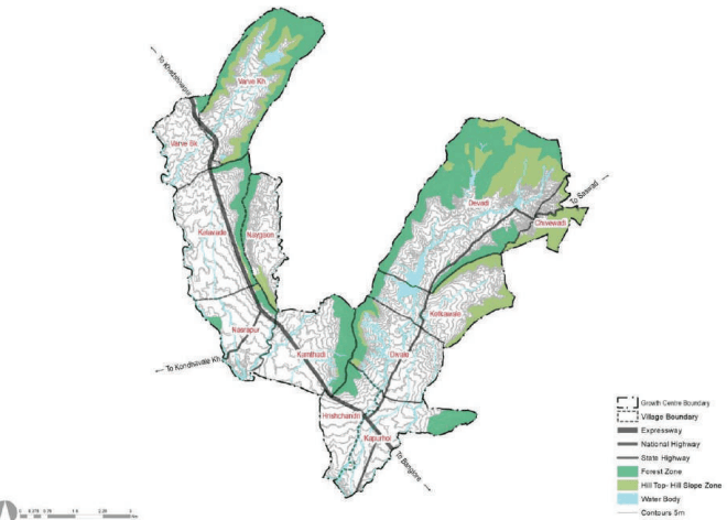
Terrain of Nasrapur is sloping towards south west with presence of hills on Northern and Eastern edge. Shivganga and Gunjavani rivers flow along western and southern boundary of the Growth Centre. Physiography of the area is greatly influenced by the presence of Sahyadri Hills.
Figure 34.1: Location & physiographic
Chapter 34: Growth Centre: Nasrapur
Regional Plan (RP) 1997 Analysis
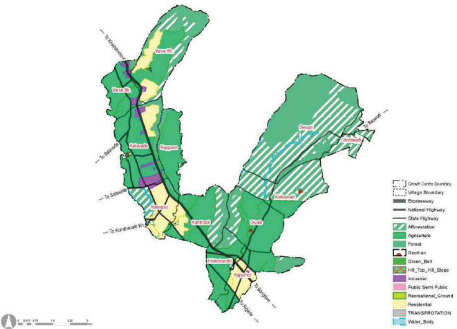
Nasrapur Growth Centre lies under Sector Q and Pune District of RP 1997. As per RP 1997, most of the area under Growth Centre was proposed to be agriculture, with four major residential nodes at Kapurvhol, Nasrapur , Varve Khurd and Kelavade villages and an industrial node at Kelavade. Small industrial parcel were also proposed along NH 48. Two bypasses were proposed to NH 48 in RP. In terms of implementation of RP1997, Industrial zone is mostly implemented and extended along NH 48. Residential area is witnessed, under-developed. 2081.73 ha of agriculture zone proposed in the Regional Plan dominates the Growth centre.
Figure 34.2: RP 1997 Zoning Map
Table 34.1RP 1997 Area Statement
Land use category
Area (Ha)
Proportion of Total Devel-oped Area (%)
Proportion of Total Area (%)
Residential
510.66
62%
9%
Gaothan
61.36
7%
1%
Industrial
79.31
10%
1%
Transportation
171.00
21%
3%
Total Developed Area
822.34
100%
14%
Agriculture
2081.73
36%
Forest
1083.75
19%
Afforestation
1657.91
29%
Water bodies
107.35
2%
Total Undeveloped Area
4930.75
86%
Total Area
5753.09
100%
Existing Land Use
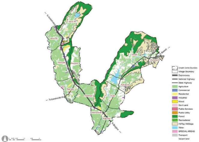
Agriculture (about 38.4%), Hill Top Hill Slope and forest (about 30.1%) and Vacant land (about 21%), dominates existing landuse composition of the Growth Centre. Sum of non-developable areas (about 92.8%) that includes agriculture, forest, hill top hill slope, special areas, recreational, and water bodies conveys environmental sensitivity of the planning area. Developed areas are about 7.2% of the total area of Growth Centre. It is dominated by residential and commercial zones.
Implementation of industrial zone proposed under RP 1997 can be seen at Kelavade. Commercial development is seen along NH 48 and in villages like Kelavade, Nasrapur and Harishchandri. Share of agricultural land is significant (38.4%) due to the presence of Shivganga and Gunjavani River and its topographic setting. Share of vacant land is also sizeable, since residential zone proposed in RP 1997 is is remained undeveloped due to lack of roads and social infrastructure. Compared to the existing demand and surge in growth of industries along NH 48, road and transport infrastructure is not adequate, has led to traffic congestion issues.
Figure 34.3: Existing land use map
Chapter 34: Growth Centre: Nasrapur
Table 34.2Existing land use area statement
Land use category
Area (Ha.)
Proportion of Total Developed Area (%)
Proportion of Total Area (%)
Residential
113.59
28%
2%
Gaothan
38.43
9%
0.7%
Commercial
40.75
10%
0.7%
Mixed
8.24
2%
0.1%
Industrial
33.41
8%
0.6%
Public - semi Public
47.25
11%
0.8%
Transport
127.57
31%
2.2%
Public Utilities
2.72
1%
0.05%
Total Developed Area
411.97
100%
7.2%
Agriculture
2206.52
38.4%
Forest
1031.20
17.9%
Hilltop Hillslope
702.79
12.2%
Special areas
4.88
0.1%
Recreational
0.53
0.0%
Water Body
189.20
3.3%
Vacant land
1206.09
21 %
Total Non-Developed Area
5341.20
92.8%
Total
5753.17
100.0%
Key Challenges:
Residential zone proposed in RP 1997 is not developed to its full potential.
Compared to the existing demand and surge in growth of industries along NH 48, road and transport infrastructure is not adequate, has led to traffic congestion.
Scattered development has seen surrounding to Gaothans.
Absence of sewerage, storm water drainage and solid waste management sites.
34.3Proposed Role & Strategies:
Nasrapur is envisioned as ‘Heritage Tourism & Education Hub’ weighing upon following assets:
Natural setting created by hill ranging over the Northern and Eastern boundary as well as Shivganga and Gunjavani Rivers flowing on the Western and Southern edge.
Bestowed popular and some unexplored forts, along with the religious attractions (Dargah, Temples) with a potential for growth in tourism related activities and has potential to become hub for tourists, visiting salient forts with heritage tourism potential.
Considering present trend of city institutions setting up campuses at the outskirts and advent of new national/ international universities at fringes of the city to avail cheaper lands and conducive environment for learning, Nasrapur Growth Centre provides a perfect setting for development of Education Hub.
Socio - Economic Projections
Based on the URGD method, projected population for the Growth Center would be as below:
Table 34.3Population Projections
Village
2011
2018
2031
2041
Chivhewadi
738
826
990
1,117
Devadi
1,201
1,255
1,354
1,430
Divale
1,269
1,371
1,560
1,706
Harishchandri
904
2,760
3,708
3,861
Kamthadi
2,452
2,779
3,134
3,350
Kapurhol
1,533
1,651
1,869
2,036
Kelawade
2,888
6,298
8,131
8,503
Ketkawale
1,250
1,878
2,294
2,441
Nasrapur
3,812
7,034
8,767
9,118
Naygaon
402
403
405
407
Varve Bk.
926
1,201
1,461
1,604
Varve Kh.
2,230
3,413
4,362
4,805
Total
19,605
30,869
38,037
40,378
The projected resident workforce based on the projected population through the URGD method is 19,180. Considering the proposed economic activities of all the growth centres, employment distribution was proposed based on the envisaged sectoral split for that Growth Centres. Accordingly, the employment to be generated for the Growth Centre for the year 2041 is estimated to be 19,582. The proposed residential density is about 100 PPH (10,000 persons/sq km).
For the planning of sustainable and self-sufficient infrastructure and amenities distribution with less population density, the Growth Centre is considered as a single sector.
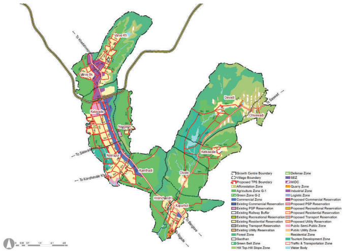
Proposed zoning would determine efficient use of land for the next 20 years. Proposed zoning plan is an output of existing landuse and physical conditions analysis; understanding of most pressing issues of the Growth Center; local knowledge of the place; and deployment of five planning goals and allied physical planning strategies. The proposed zoning area statement is presented in Table 34.4.
Chapter 34: Growth Centre: Nasrapur
Figure 34.4: Proposed zoning map
Table 34.4Proposed zoning area statement
Land use category
Area (ha)
Proportion of Total Devel-oped Area (%)
Proportion of Total Area (%)
Residential
722.13
42.26%
12.55%
Gaothan
34.29
2.01%
0.60%
Commercial
146.88
8.60%
2.55%
Industrial
111.45
6.52%
1.94%
Public semi Public
80.86
4.73%
1.41%
Tourism Development
275.54
16.13%
4.79%
Transport
330.88
19.36%
5.75%
Public Utilities
6.64
0.39%
0.12%
Total Developable Area
1708.68
100.00%
29.70%
Agriculture (G-1)
1996.29
34.70%
Forest
1033.61
17.97%
Afforestation
177.93
3.09%
Hilltop Hill slope
609.58
10.60%
Green Belt
25.28
0.44%
Recreational
15.08
0.26%
Water Body
173.49
3.02%
Quarry
13.19
0.23%
Total Non-Developable Area
4044.45
70.30%
Total
5753.13
100.00%
Translating Goals into the Plan
Proposed zoning ensures that the sectoral development goals are clearly conveyed through it. For brevity, proposed sectoral goals and their corresponding physical planning strategies are mentioned in figure below:Proposed zoning ensures that the sectoral development goals are clearly conveyed through it. Proposed sectoral goals and their corresponding physical planning strategies are mentioned in Table 34.5
Table 34.5Goals and physical planning strategies
Goals
Development Sector addressed
Physical planning strategies
Prudent
Employment and housing
Work- Live Hubs
Convenient
Roads and mass transport
Movement Lattice
Resilient
Environment protection
Green- Blue connectors
Efficient
Infrastructure and utilities
Decentralised resource management
Self- sufficient
Social facilities
Walkable Neighbourhoods
‘Prudent’ goal would be addressed by Work-live concept that implies working closer to homes. As explained in proposed vision framework, in context of metropolitan regions it is assumed that maximum 30% of the resident workforce would be employed within a suburb/ town where they reside.
For Nasrapur Growth Center, work-live concept is applied by
Designating residential zones within 500m around industrial and commercial zones to minimize work related trips for atleast 30% of resident workforce.
Expansion of industrial zone at Kelavade, Varve Bk, Varve Kh.of total area 112.81 Ha. along NH48.
Designating commercial zone area from Kelavade to Kamthadi village of total area 147.33 Ha. , along NH 48.
Designating tourism development zones to foster employment to the local population by promoting tourism related economic activities.
Town Centre is proposed in Kelvade village.
Adjoining to Education complex , District court , Trauma care centre, residential zone is proposed in Kelavade village.