Khed Shivapur is envisioned as an Ancillary Industrial Hub. It leverages upon the potential for extension of existing Industrial Cluster with land reserved by RP Zoning. Existing accessibility from NH 48, and enhanced location potential created by vicinity of 110M MSRDC Ring Road and new proposed Chhatrapati Sambhaji Raje International Airport makes it potential hub for MSME industries. Its nearness to Shirval MIDC (about 22km) in Satara District and PMC (about 23km) attracts industrial development.
Promote ancillary industrial activities by consolidating cluster development leveraging upon high existing demand.
Promote logistic and warehousing activity, Truck Terminal and Bus Depot leveraging upon high demand along Mumbai Bangalore National Highway (NH 48) and proposed Chhatrapati Sambhaji Raje International Airport Road (MDR 36).
Encourage residential development around proposed industrial zone and along NH 48, promoting work-live concept.
Developments of all major social amenities for residential and industrial zone are within walk able distance.
Establish green and blue network by designating green belt along Shivganga River and protecting all natural streams.
Development of bypass to Mumbai Bangalore National Highway (NH 48) and Proposed Airport Road (MDR 36) to avoiding congestion.
Development of Trauma care with air ambulance along with fire station and bus depot facility on Mumbai Bangalore National Highway (NH 48).
Industrial zone and Logistic zone along Mumbai Bangalore National Highway.
Integrated Industrial Town Planning Scheme in Kasurdi and Khed Shivapur village ( 362.89 Ha).
Town Centre at Shivapur (3.76 ha).
Wholesale Market at Shivapur (1 ha).
Bus Depot at Khed Shivapur, Kasurdi (2.0 ha)
Sport Complex at Shivapur, Velu (1.21 ha)
Educational Complex at Shivapur and Velu (2.94 ha)
Multi Purpose Ground at Kasurdi (0.61 ha)
Hospital and Trauma Care Centre at Khed Shivapur (1.50 ha)
Bypass roads to Mumbai-Bangalore National Highway (NH 48).
Truck Terminal at Kasurdi (1.61 Ha).
Public Housing at Shivapur (3.67 Ha).
33.3Proposed Role and Strategies
Khed Shivapur Growth Centre is envisioned as an ‘Ancillary Industrial Hub’ leveraging upon following assets;
Potential for extension of existing Industrial Cluster, with land reserved by RP Zoning.
Existing accessibility from NH 48, and enhanced location potential created by 110M MSRDC Ring Road and Proposed CSR International Airport makes it potential hub for MSME industries, logistics and warehousing activities.
Residential development around Work Hub encouraged through Integrated Town planning Scheme.
Protection of Green-Blue lattice by designated green belt along blue line of Shivganga river,
Protection of Hills and water bodies
Table 33.3Population Projections
Village
2011
2018
2031
2041
Kasurdi
1,512
2,849
3,832
4,242
Khed Shivapur
3,665
4,421
5,076
5,406
Ramnagar
2,349
2,624
3,134
3,526
Sasewadi
1,198
1,349
1,630
1,845
Shindewadi
2,054
2,680
3,344
3,738
Shivapur
2,588
2,814
3,234
3,557
Shivare
2,412
3,349
4,088
4,426
Velu
4,256
4,980
6,074
6,859
Total
20,034
25,066
30,411
33,599
The projected resident workforce based on the projected population through the URGD method is 16063. Considering the proposed economic activities of all the growth centres, employment distribution was proposed based on the envisaged sectoral split for that Growth Centres. Accordingly, the employment to be generated for the Growth Centre for the year 2041 is estimated to be 50,702. The proposed residential density is about 125 PPH (12,500 persons/sq km).
For the planning of sustainable and self-sufficient infrastructure and amenities distribution with less population density, the Growth Centre is considered as a single sector.
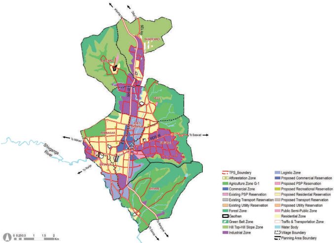
The proposed zoning would guide and determine the optimal and efficient land use for the next 20 years. The proposed zoning plan is an output of existing land use and physical conditions analysis, understanding of most pressing issues of the Growth Center, local knowledge of the place and deployment of five planning goals and allied physical planning strategies. The proposed zoning area statement is presented in Table 33.4.
Chapter 33: Growth Centre: Khed Shivapur
Figure 33.4: Proposed Zoning Map
Table 33.4Proposed Zoning Area Statement
Land use category
Area (ha)
Proportion of Total Devel-oped Area (%)
Proportion of Total Area (%)
Residential
476.48
31.15%
12.50%
Gaothan
30.87
2.02%
0.81%
Commercial
63.91
4.18%
1.68%
Industrial
465.30
30.42%
12.21%
Public semi Public
36.67
2.40%
0.96%
Transport
260.23
17.01%
6.83%
Logistic Zone
190.73
12.47%
5.00%
Public Utilities
5.46
0.36%
0.14%
Total Developed Area
1529.65
100.00%
40.12%
Afforestation Zone
29.93
0.79%
Agriculture
803.52
21.08%
Forest
656.56
17.22%
Hilltop Hillslope
716.29
18.79%
Green Belt
7.93
0.21%
Recreational
11.86
0.31%
Water Body
56.54
1.48%
Total Non-Developable Area
2282.64
59.88%
Total
3812.29
100.00%
Proposed zoning ensures that the sectoral development goals are clearly conveyed through it. Proposed sectoral goals and their corresponding physical planning strategies are mentioned in Table 33.5.
Table 33.5Goals and Physical Planning Strategies
Goals
Development Sector Addressed
Physical Planning Strategies
Prudent
Employment and housing
Work- Live Hubs
Convenient
Roads and mass transport
Movement Lattice
Resilient
Environment protection
Green- Blue connectors
Efficient
Infrastructure and utilities
Decentralized resource management
Self- sufficient
Social facilities
Walkable Neighbourhoods
For Khed Shivapur Growth Center, the Work-Live concept is applied by:
Designating residential zones following RP zones within 500 m around industrial and commercial zones along transport corridor to minimize work-related trips for at least 30% of the resident work force.
Expansion of industrial zone at Shindewadi, Kasurdi, Velu, Shivapur and along NH48.
Designating logistic zone at junction of NH 48 and MDR 36 sandwitched betweeen residential area of Kasurdi village and Ramnagar village.
Town Centre is proposed in Shivapur near gaothan.
Wholesale market is proposed in village Shivapur.
Out of the total proposed industrial zone over 18,660 Ha, industrial use over 470 Ha is envisaged in Khed Shivapur Growth Centre, both based on projected employment and 50 workers/ha density.
The industrial zone as per ELU was 65.3 ha while 194.28 ha was proposed in RP 1997. The planning intent is to consolidate industrial zone around existing and balance industrial zone proposed at Shindewadi, Kasurdi, Shivapur, Velu and along NH 48. Integrated Industrial Town Planning Scheme is proposed at Kasurdi to consolidate the industrial development, enabling better trunk infrastructure. Thus, considering the existing scenario of industrial development, strategic infrastructure proposals within the growth centre and planning intent, 464.32 Ha of industrial zone is proposed.
The total logistic land use requirement of the Study Area is estimated to be 2020 Ha. considering projected demographics and area requirement of 55 sqm built-up area per person. 200 Ha of this estimated area is anticipated in Khed Shivapur Growth Centre. However, considering the proposed role of the GC, the prevailing trend
Chapter 33: Growth Centre: Khed Shivapur
of warehousing and supplementary industries and the proposed strategic infrastructure projects, logistic use is proposed over 190.73 Ha. This zone, being proposed in Integrated Industrial Town Planning Scheme at Kasurdi and Khed Shivapur village near Industrial zone adjoining to Mumbai Bangalore National Highway (NH 48) and Proposed Airport Road (MDR 36).
Land requirement for the residential zone is estimated based on a net residential density of 125 PPH. Further, 45% add-on is considered to account for amenity (15%), open spaces (10%) and roads (20%). Accordingly, the total gross area required for the projected GC population of 33,599 by 2041 is estimated to be 390 Ha.
Considering the projected population, net residential density, proposed role and existing growth trends within the Growth Centre, 476.48 Ha of gross residential zone is proposed. As per the Work Live hub concept, consolidated residential zoning is proposed in the Growth Centre. Existing gaothans at villages such as Shivapur, Khed Shivapur and Ramnagar are considered as social nucleus and residential real estate hot spots. To drive the future growth, a residential zone is allocated at periphery of 200m along the gaothan of these villages for future expansion. Residential spread is proposed in Velu and Kasurdi villages, supporting the work live concept.
Land requirement for the commercial zone is estimated based on URDPFI guidelines, i.e. 0.6 ha per 1,000 population.The total commercial zone works out to be 26 Ha, while 63.91 Ha commercial zone is proposed to account for equitable distribution of commercial activities. Commercial zone is proposed at 2 major nodes, along NH 48 in Khed Shivapur village and other near town center in Shivapur village.
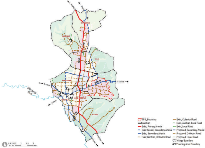
30M wide Bypass to NH 48 is proposed in two parts. One runs from Shindewadi to Kasurdi on the east of NH 48, while the other runs from Khed Shivapur to Varve Bk in Nasrapur Growth Centre, on the west of NH 48.
For connectivity to Airport, MDR 36 is proposed as 30M wide secondary road.
Grid-iron pattern of collector roads is proposed in the Growth Centre covering the entire residential and industrial zone.
Collector roads (15-24m wide) follow spacing of 300-500m while Secondary arterial (30-45m wide) follow a grid of 1 to 2 km covering the entire residential zone.
Secondary arterials have the flexibility to run a dedicated Bus service for faster transport and support the feeder system & last mile connectivity.
All the proposed roads are to be designated with at least 3m wide footpath on either side of the road, as the ‘pedestrian right of way’ and as a ‘hawker-free zone’.
Figure 33.5: Proposed Transport Network Map
Table 33.6Proposed Transport Network Statement
Road Category
Road names/ ROWs
Proposed ROWs
Authority
Total Length (km)
Total road development cost (INR Cr)
Primary
NH48
60
NHAI
11.11
Secondary
SH 126
30
PWD
1.22
MDR 36
30
PWD
5.25
MDR 41
30
PWD
0.35
VR (Total)
30
ZP
3.56
Tertiary
MDR 36
24
PWD
1.44
ODR 108
18
ZP
0.88
VR (Total)
15,18,24
ZP
13.69
Local
MDR 41
12
PWD
0.29
VR (Total)
9,12
ZP
0.95
DP Roads
Secondary
30
PMRDA
9.07
132.30
Internal Road
30
PMRDA
2.92
42.55
Tertiary
24
PMRDA
7.21
39.67
18
PMRDA
36
254.00
15
PMRDA
10.99
59.38
Local
12
PMRDA
2.57
7.58
Chapter 33: Growth Centre: Khed Shivapur
12
NHAI
22.18
-
9
PMRDA
0.42
2.20
Total Road Length
91.36
537.68
Application of this concept is carried out as follow:
Afforestation zone is proposed at undulating plains at the bottom of hill.
The existing forest areas are designated as protected areas.
Green belt is reserved between river bank up to blue line for Shivganga River ;
All existing streams and water bodies are marked and to be protected.
These protected Green-Blue features are recommended to be connected by a 30-45 m wide secondary arterial road that would be upgraded as a tree-lined avenue by developing NMT corridors (>3 m each) on both sides of the road and segregated from footpaths.
Green lungs are proposed within 500 m walkable distance covering an area of 19.79 ha. These green lungs include active and passive recreational spaces. The total active recreational space works out to be 8.6 ha that include playgrounds, sport complex, stadium and multi-purpose ground. And the total passive recreational space works out to be 11.16 ha that include gardens, town park/ regional park, bio diversity park and green belt.
A water treatment plant over an area of 0.91 ha is proposed at Shivapur.
Two Sewage Treatment Plant of area 0.40 ha, and 0.48 ha is provided for the Growth Centre at Khed Shivapur and Shivapur village considering the topography and gravity system away from the residential development.
Two Solid Waste Management site of area 0.70 ha and 0.33 ha are proposed at Velu and Shivapur village based on clustered approach to serve few Growth Centers and is located central to the cluster.
Effluent Treatment Plant (0.41) is proposed centrally in Industrial and Logistics zone proposed at Kasurdi.
Fire station is provided along MDR 36 in Kasurdi village, Existing crematorium and burial grounds are maintained and expanded wherever required and feasible.
Table 33.7Proposed Infrastructure Demand
Infrastructure Sys-tem
Demand (2041)
Unit
Area Require-ment (In Ha)
33.2Existing Situation Analysis
Khed-Shivapur Growth Centre comprises of 8 villages, three from Haveli Taluka and rest five from Bhor Taluka. Khed Shivapur, Shivapur and Ramnagar Village lies in Haveli Taluka, whereas Shivare, Kasurdi, Velu, Sasewadi and Shindewadi villages lie in Bhor Taluka. Area of the Growth Centre is about 3812 Ha.and its population was about 20,034 as per Census 2011.
Key strength of the growth centre is its location is divided on both side of Mumbai Bangalore National Highway which is acting like major spine and its in the vicinity of the PMC, Shirval MIDC in Satara District.
Khed-Shivapur Growth Centre is located on the south of PMR Region along the Mumbai-Bangalore National Highway (NH 48). It shares its boundary with Khadakwasla Growth center on the north and Nasrapur Growth center on its south.
It is connected to PMC to the north by Mumbai-Bangalore National Highway (NH 48) and State Highway (SH 126). It is also connected to proposed CSR International Airport Saswad through MDR 36 at a distance of 28 km. The approximate distance of Khed-Shivapur, from PMC and PCMC is 23 km and 46 km, respectively. Shirval MIDC in Satara District is 22 kms away from the Growth Centre.
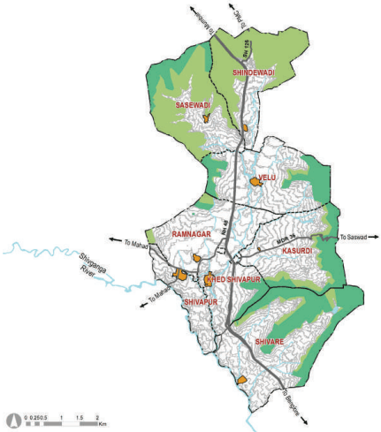
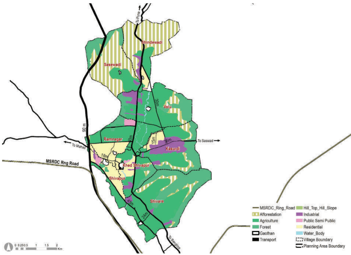
Terrain of Khed Shivapur is a flat in the centre to hilly on northern and eastern side. Shivganga River flows along the south-western boundary of the Growth Centre. Hilly topography is observed in the northern and eastern side of the Growth Centre. Forest cover is mostly observed along eastern boundary of Growth centre and also in Sasewadi and Velu village on western boundary.
Figure 33.1: Location and Physiography
Contours 5m NH SH -MDR Other District Road Gaothan Forest Zone Hill Top-Hill Slope Zone Water Body Village Boundary Planning Area Boundary
Chapter 33: Growth Centre: Khed Shivapur
Regional Plan (RP) 1997 Analysis
Khed Shivapur is a part of Sector Q which was ‘around Shivapur-Nasarapur-Kikwi in the developing belt of land on Pune-Satara road from Sindewadi to Shirval’ in Sanctioned Regional Plan Pune 1997. It was a long belt of 35 Km and comprising 32 villages, among which Khed Shivapur growth centre covers 11Km belt. 194.28 Ha of Industrial development to be developed by 2011 in Khed Shivapur Growth centre was expected. Pune Bangalore National Highway (NH 48) is proposed to be widened to 60m with including 12 m wide parallel service road on either side. 90m Expressway is proposed as a diversion to Pune Kolhapur NH from Bhambavade upto Kolavadi , Bypass link of 45m parallel on its western side of NH 48 from Sarole village upto Shivapur village. Truck terminal cum parking zone of 9 Ha was proposed in Khed Shivapur village so as to cater truck parking and allied activities which are currently taking place on highway but this reservation is not developed as per RP.
Utility Sites
Total Area
Water Supply
2.43
MLD
0.1
1 WTP
0.91 ha
Sewerage
2.42
MLD
0.36
2 STPs
0.87 ha
Solid Waste
6.72
Tones/day
NA
2 SWM
1.03 ha
This goal is set to increase the livability index of the Growth Centre. To do that, amenities are proposed within 500 m distance, leveraging the concept of Walkable Neighbourhoods. The concept entails providing basic infrastructure and services for education, health, sports, and recreation within the neighbourhood to have easy access to them by foot.
Amenity provision is made for the projected population by 2031 (30411 Population)
Neighbourhood level amenities are located within a 500 m-1000 m radius from residential zones and are connected by collector/local roads to improve their accessibility from other neighbourhoods.
Town level amenities are distributed across the Growth Centre and are accessible by mass transit modes such as a metro or a bus system.
Amenity locations are decided by prioritising government-owned lands, then amenity spaces, considering 15% of larger plots. Private lands are considered the ultimate resort.
It is ensured that these amenities are made accessible with an appropriate road width as defined in the planning norms and as highlighted in DCPR.
Education: Primary Schools and Secondary Schools are clubbed together and provided at newly opened up residential. Wherever possible, expansion to the existing ZP schools is proposed with proper road access to each amenity. At some locations PG is provided adjoining to school to enhance its facilities. Educational Complex is provided in village Velu, Shivapur to serve the population of surrounding rural area as well.
Health: Health Centres are provided considering walking radius within a Neighbourhood. There are 2 Health Centers are proposed in Kasurdi and Khed Shivapur and 1 HC extension in Velu village, Hospital and Trauma Care Centre is provided at Khed Shivapur along NH 48. Multipurpose ground is provided to facilitate air ambulance facility near Trauma Care Centre for easy accessibility.
Socio-Cultural: 3 Community halls are provided considering walking distance within a neighbourhood. Socio Cultural centre is provided at Shivapur.
Open Space: Considering the walkability, open spaces are spatially distributed, such that they acts as a breathing lungs for surrounding neighborhoods, Considering spatial distribution 9 playgrounds and 7 gardens are proposed in growth centre. Sports Complex is proposed on government land in Velu village and one multipurpose ground is proposed in Kasurdi village which will developed through TPS mechanism.
Commercial:Shopping Centre/ Market is proposed at existing commercial node/ near existing settlement; Town Centre is proposed in Shivapur village. A wholesale Market is proposed in Shivapur village, forming a major commercial node near 110M MSRDC Ring Road.
Residential: Public Housing is proposed at 4 sites in Shivapur and Ramnagar village for PMAY and MHADA. Public Amenity is proposed at Shindewadi village.
Transport: Bus Depot is proposed at village Khed Shivapur, Kasurdi adjoining to the NH 48. Considering CTTS Truck Terminal is proposed in Kasurdi village. Parking spaces are proposed near amenities that provide for a larger crowd congregation.
Civic facilities requested by various government authorities: In additions to above, amenities such as Police Station for Rural Police is proposed on MDR 36.
Table 33.8Summary of Land Ownership of Proposed Amenities
Land Ownership
No of Amenity
Total Area (ha)
Government
22
17.33
Private
22
14.88
Amenity Space
3
0.48
Trust
3
1.91
Total
50
34.59
Chapter 33: Growth Centre: Khed Shivapur
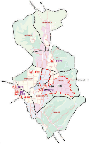
Town Planning Scheme: PMRDA envisages implanting the proposals of Development Plan through enabling provision of Town Planning Schemes which will considerably reduce liability towards cost of acquisition of land required for social and physical infrastructure. To achieve economic role Ancillary Industrial Hub & Work-Live relation Integrated TPS is proposed with predominant Industrial and Logistic zone along with integration of Residential zone and commercial zone with social infrastructure in part of Kasurdi and Khed Shivapur village.
The reservations developed by TPS mechanism is as follows:
a. Strategic Project: Bus Depot,Truck Terminal, Effluent treatment plant, Sewage treatment plant, Water treatment plant, Solid Waste Management, Road network.
b. Amenities: Community hall, Garden, Health centre, Multipurpose ground, Playground Primary School and Trauma care centre.
The other proposals/reservations of the Development Plan are proposed to be acquired and developed through the mechanism of Accommodation of Reservation and Transfer of Development Rights(TDR) policy. It is estimated that all proposed roads and 50% of the public reservations will be acquired through TDR/FSI/ AR.
The remaining reservations will be acquired under the provision of the Land Acquisition Act by paying monetary compensation.
Figure 33.6: strategic projects
TPS Boundary Planning Area Boundary cVillage Boundary Government Authority Requirement Town Level Transportation Level
Figure 33.2: RP 1997 Zoning Map
Table 33.1RP 1997 Area Statement
Land use category
Area (ha)
Proportion of Total Devel-oped Area (%)
Proportion of Total Area (%)
Residential
311.69
43%
8.18%
Gaothan
29.60
4%
0.78%
Public semi Public
28.97
4%
0.76%
Industrial
194.28
27%
5.10%
Transport
160.89
22%
4.22%
Total Developed Area
725.43
100%
19.03%
Agriculture
1449.42
38.02%
Afforestation
909.37
23.85%
Forest
697.09
18.29%
Hill Top Hill Slope
0.87
0.02%
Water Body
30.11
0.79%
Total Undeveloped Area
3086.88
80.97%
Total
3812.31
100.00%
Existing Land Use
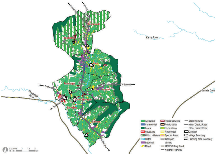
The Khed Shivapur Growth centre is observed to flourish small and medium scale Industrial growth along NH 48 and in proximity of PMC. Existing land-use composition comprises of majority Agriculture (about 36%), Hill Top Hill Slope (about 20%) , Forest (about 17%) and Vacant land (about 18%) aggregating in total Non Developable area(about 93%).
Developed areas are about 7% of the total area of Growth Centre. It is dominated majorly by industrial zone and farther by residential zone.
The Residential land-use is majorly developed near Shivapur and Khed Shivapur village along with sporadic growth near other Gaothans. The Industrial land-use is distributed in three different areas–first, located on the Northern side along NH48 in village Shindewadi and Velu; second, located on the Southern side along the river in village Khed Shivapur and Shivare; and third, along MDR 36 in village Kasurdi is surrounded by HTHS, Agriculture zone and Residential zone on the Eastern and western side.
Figure 33.3: Existing Land Use Map
Chapter 33: Growth Centre: Khed Shivapur
Table 33.2Existing Land Use Area Statement
Land use category
Area (ha)
Proportion of Total Devel-oped Area (%)
Proportion of Total Area (%)
Residential
22.12
8%
1%
Gaothan
27.76
10%
1%
Commercial
22.90
9%
1%
Industrial
65.30
24%
2%
Public and semi public
32.58
12%
1%
Public Utility
0.68
0%
0%
Transportation
96.60
36%
3%
Mixed landuse
0.03
0.012%
0.001%
Total Developed Area
267.97
100%
7%
Agriculture
1379.19
36%
Water bodies
49.41
1%
Recreational
3.33
0%
Hilltop Hill slope
748.76
20%
Forest
656.70
17%
Special areas
4.80
0%
Vacant
702.00
18%
Total Un-developed Area
3544.20
93%
Total Area
3812.18
100%
Compared to the existing demand and surge in growth of industries along NH 48 and transport infrastructure is not adequate. It has led to traffic congestion issues of the Growth Centre.
Existing residential development is not observed to be occurred as per Residential zone proposed in Regional Plan 1997, instead sporadic development along transport corridor and near Gaothan area is observed.
Inadequate Social amenities which leads to imbalance in Work-live concept.
Major Industrial Development is concentrated only along NH 48 instead of expected growth in Kasurdi and Shivapur village as well Unauthorized residential and industrial development is observed surrounding Gaothans in agriculture zone.
Hilly area surrounded by Growth center leads to bottleneck of NH 48 and SH 126 at entry of pune.
Rain water coming from hills blocks the road and eastern area.