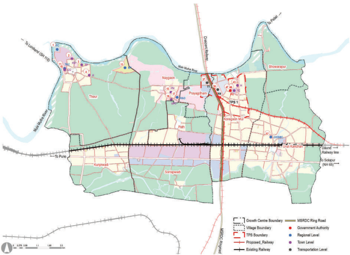
Uruli Kanchan is envisioned to be developed into an “Agro Processing Hub”. The primary reason to assign this economic role to Uruli Kanchan is to leverage the agro-processing activities prevailing in this area along with the presence of institutions such as the Sugar Institute. Further, this area falls under the irrigation command area, showcasing good quality agriculture produce.
Develop the area into an Agro-Processing Hub to foster activities such as agro-processing, food processing, high-value agriculture, agro-tourism
Develop regional linkages such as MSRDC Ring Road and Crescent Railway projects
Promote logistic activities supporting agro-processing industry
Promote Work-Live hub concept by increasing residential development adjacent to existing industrial activities
Develop bypass to primary roads avoiding congestion
Develop a grid network of secondary and tertiary roads for a smooth movement within the Growth Centre
Develop pilgrimage and agro-tourism facilities at Theur
Promote self sufficient town by proposing required amenities and utilities for the projected population
Protect all the natural streams in the Growth Centre.
Establish green-blue links by connecting streams, forest and green belt along the Mula-Mutha River
Crescent Railway and its station at Koregaon Mul
MSRDC Ring Road
Agro-processing and R&D Hub at Sortapwadi
Logistic Hub at Koregaon Mul
Town Planning Scheme at Koregaon Mul
Wellness Centre at Theur
Tourist Cluster at Theur consisting Tourist Centre, Cultural Center and Town Park
Regional Park (botanical garden) along the Mula-Mutha River at Naygaon
Sports Complex at Naygaon
Public Housing Project at Naygaon
Existing Situation Analysis
Uruli Kanchan is a moderately dense town with horizontal growth along the existing railway line (Pune- Daund) and NH-65. The majority of land in this area is under agricultural use, with built-up areas concentrated around Uruli Kanchan, followed by Kunjirwadi, Theur, Sortapwadi and Koregaon Mul villages.
Uruli Kanchan Growth Centre has nine villages, namely Bhowrapur, Koregaon Mul, Kunjirwadi, Theur, Uruli Kanchan, Sortapwadi, Prayagdham, Naygaon and Peth. The total area of the GC is 7214.34 Ha. According to Census 2011, the Growth Centre population was 66,971, and the estimated population for 2018 is 92,161 with 38,683 resident workforce.
Uruli Kanchan Growth Centre enjoys great locational advantage with its proximity to adjoining Loni Kalbhor, Wagholi areas and strong regional connectivity through existing and proposed infrastructure developments such as MSRDC Ring Road, national highway, state highway and existing railway line.
A portion of the GC was part of the RP 1997, falling under Sector K. RP 1997 recommended residential and industrial zones in the GC, attracting many planned layout developments in the area.
Uruli Kanchan Growth Centre is located on the eastern side of PMR within Haveli taluka. It shares a boundary with Loni Kalbhor on the west with rural areas on the north, east and south. It is approximately 36 km from Pune city.
Uruli Kanchan has main connectivity through Pune-Solapur National Highway (NH-65) and the existing Pune-Daund railway line. The proposed MSRDC Ring Road and Crescent Railway Line passing north-south through Koregaon Mul and Uruli Kanchan, connecting NH-65 and the existing railway line. Further, the GC enjoys robust regional connectivity through NH-548DD and SH-116, connecting it with Wagholi Growth Centre and Satara. MDR-138 connects villages such as Kunjirwadi, Peth and Uruli Kanchan to NH 548DD while MDR-34 connects Theur village to Uruli Kanchan railway station.
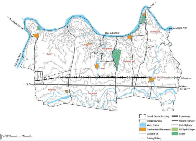
Figure 31.1: Location and Physiography
Mula-Mutha River edges the northern part of the Uruli Kanchan Growth Center, while the southern edge is lined by two canals, i.e. Sortapwadi canal and Mutha right bank canal. The entire area falls under the irrigation command area of the Mutha right bank canal. The highest point is 565 m altitude to 520 m with a gradient of about 1:0.0079 depicting a very gentle slope towards the Mula-Mutha river. 116.11 ha of forest areas are present in Koregaon Mul and Naygaon.
Uruli Kanchan was one of the four urban growth centres proposed in RP 1997, for which Sector K plan was sanctioned. In the said Growth Centre, western part of Sector K has been considered.
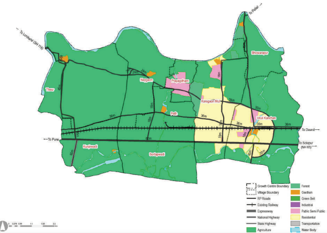
Within Sector K of the RP 1997, residential zoning over 776 ha was proposed at Uruli Kanchan and Koregaon Mul. 77.52 % of the GC area (5,592.91 ha) was kept as agricultural use in RP 1997 zoning. Prayagdham occupied a majority of the public-semi-public area.
31.2Proposed Role and Strategies
Uruli Kanchan is positioned as an ‘Agro-Processing Hub’, and the key reasons for this are as follow:
This area falls under the protected agriculture area of the irrigation command area, thus promoting the agroprocessing activities
Leverage the opportunity to foster FMCG development due to added connectivity through nearby proposed CSR International Airport at Saswad
Crescent Railway and MSRDC Ring Road will further enhance connectivity for the cargo facility
Leverage existing mature setup of green-house and horticulture in the area
Existing residential development at Uruli Kanchan and Koregaon Mul provides an opportunity for a Work-live hub
Considering the above, three distinct nodes are proposed in the GC at Uruli Kanchan, Koregaon Mul and Theur. Industrial zone , promoting agro-processing activities is proposed between Railway and Highway, leveraging its role of Agro Processing Hub where as a logistic zone, supporting the FMCG segment is proposed at Koregaon Mul adjoining the Crescent Railway station. Theur forms one of the major tourist destination of PMR
Table 31.3Population Projections
Villages
2011
2018
2031
2041
Bhowrapur
823
859
894
918
Koregaon Mul
4,818
14871
17,369
19,887
Kunjirwadi
8,421
10573
12,782
14,399
Naygaon
2,589
2913
3,398
3,753
Peth
2,076
2347
2,306
2,272
Prayagdham
1,899
2589
3,761
4,623
Sortapwadi
6,366
7174
8,391
9,279
Theur
9,674
10020
9,829
Application of this concept is carried out as follow:
The existing forest areas at Koregaon Mul, Bhowrapur and Theur are designated as protected areas.
Green Zone to be reserved between the river bank up to the blue line for Mula-Mutha River.
All existing streams to be protected.
These protected Green-Blue features are recommended to be connected by a 30-45m wide secondary arterial road that would be upgraded as a tree-lined avenue by developing NMT corridors (>3 m each) on both sides of the road and segregated from footpaths.
Green lungs are proposed within 500 m walkable distance covering an area of 260.55 ha. These green lungs include active and passive recreational spaces. The total active recreational space works out to be 15.70 ha that include playgrounds, sport complex, stadium and multi-purpose ground. And the total passive recreational space works out to be 244.85 ha that include gardens, town park/ regional park, bio diversity park and green belt.
One solid waste site is proposed, one at Bhowrapur on government land along the SH-117, serving Uruli Kanchan village within a 3 km radius
2 WTPs are proposed at Naygaon along Mula-Mutha and Sortapwadi along Mula-Mutha Right Bank Canal.
2 STPs are proposed at Bhowrapur (government land) and Theur (government land)
Renewable energy sites could be proposed and are recommended on higher elevations within the Quarry area. However, they would be finalised after a detailed study.
Currently, four cremation grounds are present in the Growth Centre. Thus no new additional cremation grounds are proposed.
No new burial ground is proposed as the existing burial ground is located at Theur.
Fire brigade station is proposed at Koregaon Mul adjacent to Town Centre along SH-117
ETP is proposed at Koregaon Mul adjacent to logistic park along Mula-Mutha River
Table 31.8Proposed Infrastructure Demand
In terms of transport planning, the Regional Plan proposed a radial road connecting the staggered segments of SH-117. Forest areas occupied 130.83 ha of land within the delineated Growth Centre boundary.
Figure 31.2: RP 1997 Zoning Map
Table 31.1Regional Plan 1997 Land Use Area Statement
Land use category
Area (ha)
Proportion of Total De-veloped Area (%)
Proportion of Total Area(%)
Residential
776.22
64.58
10.76
Commercial
0
0.00
0.00
Industrial
0
0.00
0.00
Public and semi public
171.46
14.27
2.38
Transportation
254.19
21.15 3.52
Total Developed Area
1201.87
16.66
Agriculture
5591.77
77.52
Water bodies
288.73
4.00
Forest
130.83
1.81
Total Undeveloped Area
6011.33
83.34
Total Area
7213.20
100.00
Existing Land Use
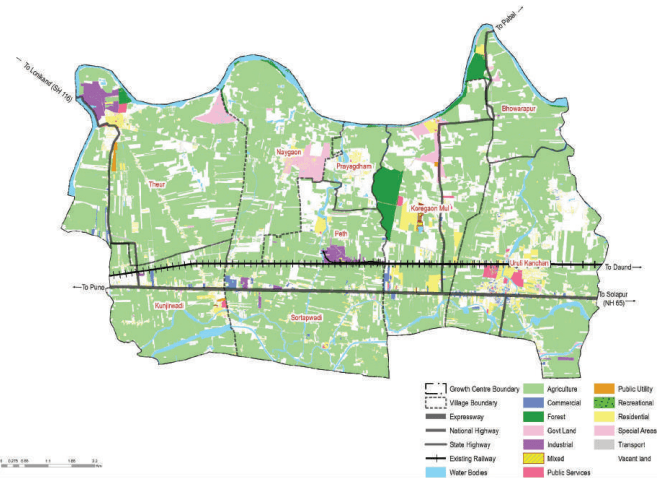
Uruli Kanchan GC has witnessed rapid growth in recent years due to its proximity to PMC and Loni Kalbhor. However, most of the land in this GC is still under agricultural use (63.25%), with built-up areas concentrated around Uruli Kanchan, followed by Kunjirwadi, Theur, Sortapwadi and Koregaon Mul. Residential and commercial areas are only 2.68% and 1%, respectively. Such low development indicates underutilisation of the strategic location of the Growth Centre. Although the area under development is relatively small, mixed-use development has dispersed across the area, especially in Sortapwadi and Kunjirwadi.
Forests cover 1.61% of the total land use. Public utilities along with public and semi-public use, contribute about 0.95% only of the existing land use. This Growth Centre hosts well-known Prayagdham Ashram, Ashtavinayak temple, BAIF and Vasantdada Sugar Institute.
ELU indicates that most of the industrial and commercial corridor development in the GC has taken place in areas between the existing railway line and NH-65. Major residential nodal development is seen in Uruli Kanchan, whereas Koregaon Mul, Theur and Naygaon are dotted by residential developments and some areas with unplanned settlements. A number of public facilities, including schools, government offices, and health facilities are present in the GC.
Figure 31.3: Existing Land Use Area Statement
Table 31.2Existing Land Use Area Statement
Land use category
Area (ha) Poproepdo Artrieoa
n of Total Devel- Proportio(%) (%)
n of Total Area
Residential
193.28
31.52
2.68
Commercial
71.86
11.72
1.00
Industrial
40.4
6.59
0.56
Public and semi public
61.82
10.08
0.86
Public Utility
6.4
1.04
0.09
Transportation
230.71
37.62
3.20
Recreational
8.79
1.43
0.12
Defense
0
0.00
0.00
Total Developed Area
613.26
8.5
Agriculture
4562.06
63.25
Water bodies
333.67
4.63
Vacant Land*
1588.1
22.01
Forest
116.11
1.61
Total Undeveloped Area
6599.94
91.50
Total Area
7213.20
100.00
*Note: Areas calculated under residential, industrial, commercial and PSP are in real terms the building footprint areas than the parcel areas. Therefore the area calculated under vacant land includes the vacant areas adjoining the building footprints and also barren lands.
Traffic congestion at the junction of the NH-65 with NH-548 DD and SH-117, no bypass developed
Critical junctions at Uruli Kanchan Gaothan
Scattered development along the highways, especially at Kunjirwadi and Sortapwadi
Narrow and unpaved roads
Accessibility and walkability issues
Lack of amenities, such as healthcare and social centres.
Lack of recreational areas such as playgrounds and gardens.
Absence of sewerage, stormwater drainage and solid waste management sites
9,671
Uruli Kanchan
30,305
40816
47,358
52,135
Total
66,971
92161
106,088
116,937
The projected resident workforce based on the projected population through the URGD method is 52,032. Considering the proposed economic activities of all the growth centres, employment distribution was proposed based on the envisaged sectoral split for that Growth Centres. Accordingly, the employment to be generated for the Growth Centre for the year 2041 is estimated to be 38957. The proposed residential density is about 125 PPH (12,500 persons/sq km).
For the planning of public facilities distribution, Uruli Kanchan GC is divided into two sectors. Theur, Naygaon, Peth, Prayagdham, Kunjirwadi and Sortapwadi form the western sector. Koregaon Mul, Uruli Kanchan and Bhowrapur form the eastern sector.
The boundaries of this planning division are shown on the Proposed Zoning Map. The projected sector-wise population statement is in Table 31.4.
Table 31.4Projected Population - Sectors
Sector
2011
2018
2031
2041
Sector 1
35,946
35614
65,621
72,940
Sector 2
31,025
56547
40,467
43,997
Total
66,971
92161
106,088
116,937
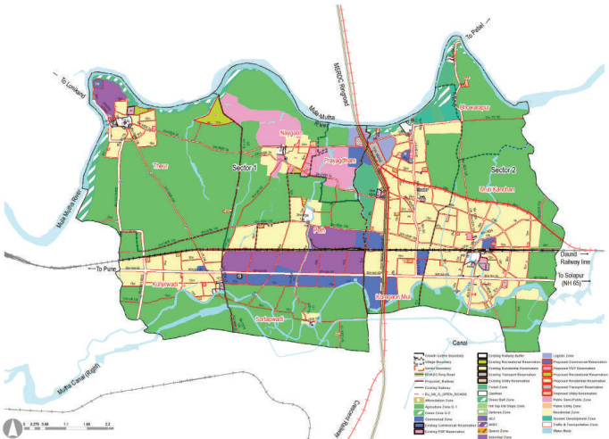
The proposed zoning would guide and determine the optimal and efficient land use for the next 20 years. The proposed zoning plan is an output of existing land use and physical conditions analysis, understanding of most pressing issues of the Growth Center, local knowledge of the place and deployment of five planning goals and allied physical planning strategies. The proposed zoning area statement is presented in Table 31.5.
Figure 31.4: Proposed Zoning Map
Table 31.5Proposed Zoning Area Statement
Land use category
Area (ha) Poproepdo Artrieoa
n of Total Devel- Proportion(%) (%)
of Total Area
Residential
1529.19
50.17
21.20
Gaothan
45.85
1.50
0.64
Commercial
250.64
8.22
3.47
Industrial
309.36
10.6
4.29
Logistics
42.64
1.40
0.59
Tourism Development
36.98
1.21
0.51
Public and semi public
277.38
9.10
3.85
Public Utility
11.99
0.39
0.17
Traffic & Transportation
544
17.85
7.54
Total Developed Area
3048.30
100
42.26
Agriculture (G1)
3507.29
48.62
Water bodies
277.87
3.85
Green Belt
204.10
2.83
Forest
119.42
1.86
Recreational
56.22
0.78
Total Non-Developable Area
4164.77
57.74
Total
7213.07
100.00
Translating Goals into the Plan
Proposed zoning ensures that the sectoral development goals are clearly conveyed through it. Proposed sectoral goals and their corresponding physical planning strategies are mentioned in Table 31.6
Table 31.6Goals and Physical Planning Strategies
Goals
Development Sector Addressed
Physical Planning Strategies
Prudent
Employment and housing
Work- Live Hubs
Convenient
Roads and mass transport
Movement Lattice
Resilient
Environment protection
Green- Blue connectors
Efficient
Infrastructure and utilities
Decentralized resource management
Self- sufficient
Social facilities
Walkable Neighbourhoods
For this Growth Center, the Work-Live concept is applied by:
Designating residential zones within 500 m around logistics, industrial and commercial areas and town centre to minimise work-related trips for at least 30% of the resident workforce
Developing logistic and commercial nodes around the intersection of Crescent Railway station and Ring Road to reduce travel time for the workforce to commute within the Growth Centre as well as to and fro other Growth Centers
Proposing Town Centre at Koregaon Mul, serving the entire GC and the surrounding rural area
Out of the total industrial zone of 18860 ha proposed for the Study Area, based on 50 workers/ha, 309.63 ha of industrial development is envisaged in Uruli Kanchan Growth Centre.
The industrial zone as per ELU was 40.4 ha, whereas RP 1997 did not propose any industrial zone. Considering the existing horticulture (green houses) and allied agricultural activities , envisaged Agro-processing role, and strategic infrastructure proposals within the Growth Centre, industrial zone over an area of 309.63 ha is proposed in Uruli Kanchan Growth Centre, in alignment with the requirement The industrial zone is proposed along the existing railway line and the national highway, expected to promote agro-tech and its ecosystem within the Growth Centre.
The total land requirement for the logistics zone for the Study Area works out to be 2040 ha by considering 55 sqm built-up-area/person, out of which 42.64 ha is anticipated within Uruli Kanchan Growth Centre.
Major regional mobility projects such as Crescent Railway and MSRDC Ring Road pass through Uruli Kanchan Growth Centre. This provides an excellent opportunity to promote logistic activities in Uruli Kanchan, and the same has been envisaged in the CTTS report.
The logistic zone would also supplement the proposed role, i.e. agro-processing hub. Thus, it is proposed over 42.64 ha at Koregaon Mul, adjoining the Crescent Railway and the MSRDC Ring Road.
Land requirement for the residential zone is estimated based on a net residential density of 125 PPH. Further, 45% add-on is considered to account for amenity (15%), open spaces (10%) and roads (20%). Accordingly, the total gross area required for the projected GC population of 116,937 by 2041 is estimated to be 1360 ha, whereas the residential use proposed covering 1529.19 ha almost aligns with the requirement. The increase in residential zone is on account of gaothan expansion at Peth, Theur and supporting the intervention of logistic activities, Crescent railway station at Koregaon Mul.
As per the Work Live hub concept, consolidated residential zoning is proposed in the Growth Centre. High-density residential developments are observed in Koregaon Mul (452.01 ha) and Uruli Kanchan (534.86 ha). 75% of the proposed residential development in the GC is proposed in these two villages, considering the existing matured residential developments and current development trends in these villages. Kunjirwadi (212.17 ha), Theur (91.5 ha) Naygaon (42 ha) and Peth (51.88 ha) form the other major residential areas of the Growth Centre. .
Commercial nodes are proposed at strategic locations primarily with an intent to integrate these developments with transport hubs, thus encouraging intense development along the transit
Land requirement for the commercial zone is estimated based on URDPFI guidelines, i.e. 0.4 ha per 1,000 population and topping up 30% (15% road, 10% open space, 5% amenity). The total commercial zone works out to be 25.64 ha.
The commercial node at Koregaon Mul is proposed over 96.45 by integrating it with the proposed Crescent Railway station at Koregaon Mul. Further, the Town Centre over 5 ha is proposed in the vicinity of this station. The second commercial node is proposed at Uruli Kanchan adjacent to the existing railway station on Pune-Daund Railway Line. Another major commercial development is proposed along the Pune-Solapur State Highway, building upon the existing trend of warehousing and other allied services development in this transit corridor. The fourth node is proposed along the NH 548 DD at Kunjirwadi, leveraging the current commercial activities along the highway.
The movement lattice concept also includes a mass transit corridor running through the Growth Center centre, high-speed rail crossing the Centre and Ring Road to encourage >50% of the residents to use mass transport for their daily commute.
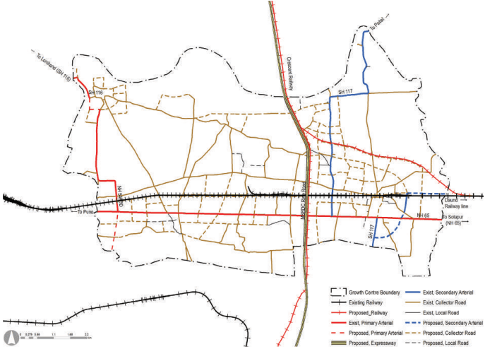
A parallel system (24 & 15 m road) to NH-65 is proposed on either sides at Uruli Kanchan, Sortapwadi and Kunjirwadi, bypassing the congested section and disconnecting it from local traffic. This bypass should be one of the top development priorities of the Growth Centre.
Another parallel system to SH-117 is proposed in north south direction
while the connector road as recommended in RP 1997 is proposed to assist in modulating the traffic.
Developing a bypass to Theur Gaothan, connecting NH 548 DD Road, avoiding the congestion within the Gaothan.
Grid-iron pattern of collector roads (15-24 m wide) is proposed at Kunjirwadi, while a radial pattern is proposed at Uruli Kanchan based on the existing alignments.
Collector roads (15-24 m wide) follow spacing of 300-500 m. Secondary arterial (30-45 m wide) follows a grid of 1 to 2 km covering the entire residential zone.
Crescent Railway (Talegaon -Chakan -Shikrapur-Uruli Kanchan) passes through the Growth centre and runs aligned with MSRDC Ring Road.
Secondary arterials have the flexibility to run a dedicated bus service for faster transport and support the feeder system and last-mile connectivity.
All proposed roads are to be designated with at least 3m wide footpath on either side of the road, as the ‘pedestrian right of way’ and ‘hawker-free zone.’
Figure 31.5: Proposed Transport Network Map
Table 31.7Proposed Transport Network Statement
Road Category
Road names/ ROWs
Proposed ROWs
Authority
Total Length (km)
Primary
NH548DD
60
NHAI
6.95
NH65
60
NHAI
11.46
Secondary
SH117
45
PWD
8.6
Tertiary
MDR120
24
PWD
1.25
MDR138
24
PWD
15.53
MDR34
24
PWD
8.56
MDR58
24
PWD
1.63
ODR113
18
ZP
0.291
ODR137
18
ZP
4.99
ODR139
18
ZP
5.4
ODR136
18
ZP
0.543
Local
VR (Total)
15
ZP
9.14
DP Roads
Primary
MSRDC Ring Road
110
MSRDC
5.11
Expressway
90
MSRTC
0
PMRDA Ring Road
65
PMRDA
0
Secondary
45
PMRDA
0
30
PMRDA
3.4
Tertiary
24
PMRDA
12.85
18
PMRDA
9.18
15
PMRDA
41.11
Local
12
PMRDA
5.02
Total Road Length
151.014
Infrastructure System
Demand (2041)
Unit
Utility Sites
Total Area (Ha)
Water Supply
8.47
MLD
2 WTPs
2.59
Sewerage
8.42
MLD
2 STPs
2.17
Solid Waste
35.08
Tones/day
1 SWM
1.12
Self-sufficient: Walkable Neighbourhoods
This goal is set to increase the liability index of the Growth Centre. To do that, amenities are proposed within 500 m distance, leveraging the concept of Walkable Neighbourhoods. The concept entails providing basic infrastructure and services for education, health, sports, and recreation within the neighbourhood to have easy access to them by foot.
Amenity provision is made for the projected population by 2031 (106,088 people)
Neighbourhood level amenities are located within a 500 m radius from residential zones and are connected by collector/local roads to improve their accessibility from other neighbourhoods.
The majority of the Growth Centre villages, such as Koregaon Mul, Uruli Kanchan and Kunjirwadi, Theur have already established urban centres. Thus the concentration of amenities is observed here.
Education: Primary schools are proposed at Uruli Kanchan and Kunjirwadi and Primary School and Secondary School is clubbed together and provided at newly opened up residential areas each at Naygaon.. Wherever possible, expansion to the existing ZP schools is proposed with proper road access to each amenity. No new college is proposed as several institutions such as Mahatma Gandhi Jr College, Mahadev Kanchan College of Pharmaceuticals Education and Research and Swami Vivekanand Pratishthan serve the area well.
Health: Health Centres are provided considering walking radius within a Neighbourhood. 5 Health centres are proposed, each at Kunjirwadi, Uruli Kanchan, Theur, Peth and Koregaon. Two general hospitals are proposed, one at Koregaon Mul which will be accessible using SH-117 and doubles up as a trauma centre. Another hospital is proposed at Theur, special to serve the pilgrims.
Socio-Cultural: Community halls are provided considering walking distance within a neighbourhood. 4 community halls are proposed, each at Uruli Kanchan, Koregaon Mul, Kunjirwadi and Theur. A Cultural Centre is proposed at Theur, again leveraging upon the current cultural activities due to the presence of Shree Chintamani Ganpati Temple.
Open Space: Playgrounds are located near schools and are split into 2 with a minimum area of 0.8 ha to improve spatial distribution wherever required. 12 playgrounds are proposed: 4 sites at Koregaon Mul, 2 sites at Kunjirwadi, 2 sites at Peth, 1 at Theur and 3 sites at Uruli Kanchan. 1 multipurpose ground at Koregaon Mul. 7 Neighbourhood Gardens are proposed 1 sites at Koregaon Mul, 1 at Theur, 2 sites at Kunjirwadi and 3 sites at Uruli Kanchan. A town park is proposed at Theur along the Mula-Mutha River to provide recreational space for pilgrims. A regional park is proposed at Theur on government land as a biodiversity park capturing the existing scenic destination for birdwatching. A sports complex is proposed at Naygaon.
Commercial: A market is provided at existing commercial nodes or near existing settlements or on available amenity spaces. 3 markets are proposed at Koregaon Mul, Kunjirwadi and Urali Kanchan each. A town centre is strategically proposed at Koregaon Mul adjoining the proposed Crescent Railway Station within walkable distance from SH-117.
Residential: Public housing is proposed at Koregaon Mul (1.4 ha) and Naygaon (19.6 ha) both on Government Land. Public housing at Koregaon Mul is recommended to be developed by MHADA.Housing for dishoused is proposed at Theur on government land.
Transport: The proposed Crescent Railway Station at Koregaon Mul and the existing railway station along the
Pune-Daund Line at Uruli Kanchan together form the transport hub. A truck terminal is proposed next to the crescent railway station surrounded by a proposed logistic zone. Bus depot is proposed at Theur, serving the pilgrimage centre of Chintamani Ganpati and another along NH 65 beside one Bus stop at Uruli Kanchan.
Civic facilities requested by various government authorities: District court (2.02 ha) is proposed as per requirement from department of District and Sessions Court, Pune. Police station (0.9 ha) is proposed at Koregaon Mul along SH-117 as per requirements from Superintendent of Police, Pune. Post office (0.7 ha) is proposed at Uruli Kanchan as per requirement from Department of Post, India (Pune MFL). Lastly, a rest house (1.18 ha) is proposed at Naygaon as per requirement from Executive Engineer of Public Work Department, South Division, Pune.
Table 31.9Summary of Land Ownership of Proposed Amenities
Land Ownership
No of Amenity
Total Area (ha)
Government Land
13
43.48
Private Land
36
66.98
Amenity Space
7
3.97
Other
16
49.24
Total
71
163.67
Implementation Strategy for the Proposed Reservations
Town Planning Scheme: PMRDA envisages implementing the Development Plan proposals by enabling the provision of Town Planning Schemes, which will considerably reduce liability towards the direct cost of acquisition of land required for social and physical infrastructure. A town planning scheme of 305 ha is proposed at Koregaon Mul with the possibility of logistic zoning at authority plots to facilitate the realisation of the proposed economic role of “Agro-Processing Hub”. The reservations proposed to be developed using the TPS mechanism are as follows:
a. Transport: MSRDC Ring Road, Crescent Railway Station
b. Amenities: Town Centre, Hospital/ Trauma Care Centre, Multipurpose ground, Market, police station, fire brigade station, district court, playground and garden, ETP and public housing
The other proposals/reservations of the Development Plan are proposed to be acquired and developed through the mechanism of Accommodation of Reservation and Transfer of Development Rights (TDR) policy. It is estimated that all proposed roads and 50% of the public reservations will be acquired through TDR/FSI/ AR. Remaining
The remaining reservations will be acquired under the provision of the Land Acquisition Act by paying monetary compensation.