Malavali is envisioned as wellness tourism. The primary reason to assign this economic role to Malavali is to leverage the scenic natural setting in the area created by Sahyadri Hill ranges, rivers, lakes and backwater. It’s a land of great historical importance, with many forts skylining the southern side in Rural Mawal. The Indrayani River flows east-west through the centre of the area. The overall setup of the area is also conducive for the development of medical leisure and amusement parks. With good accessibility by Mumbai-Bangalore National Highway (NH-48), Yashwantrao Chavan Expressway and Pune-Lonavala Railway Line, the area attracts many tourists and trekkers as a gateway to nearby tourist spots.
Growth Centre Area
73.06sq km
Population
147,109 (2041); 126,130 (2031)
Net Population Density
100 PPH
Resident workforce
51,755 (2041)
Employment
19,988 (2041)
Households
29609 (2041)
Proposed Zones
Residential (1894.44), Commercial (97.31), Tourism Devlopment Zone (212.08 Ha.)
Promote tourism activities to develop employment not only for the Growth Centre population but also for people from the surrounding rural areas
Promote consolidated/ clustered development of tourism activities.
Protect the natural wilderness setting and the green ecosystem with consolidated eco-tourism activities
Promote luxury real estate with residential development enclosed by green and unscathed landscapes
Develop a grid network of secondary and tertiary roads for a smooth movement within the Growth Centre
Promote self-sufficient town by proposing required amenities and utilities for the projected population
Ropeway and Amusement Park at Kune Nm.
Tourist Centres at Kune NM, Mudhavare and Aundhe Kh
River Front Development and Regional Park along the Indrayani River at Karla near existing MTDC resort
Regional Park and Town Park at Karla along the Indrayani River
Tourism development along the hills, dams and existing adventure park
Biodiversity Park at Kune NM in hilly area.
Public Housing at Sadapur
Connecting road link between Mumbai Pune Expressway and National Highway 48.
28.2Existing Situation Analysis
Malavali Center comes under Mawal taluka and comprises 19 villages, namely, AundheKh.,Aundholi, Bhaje, Boraj, Devale, Devdhar, Dongargaon, Karla, Kune NM, KusgaonBk, Malavali, Mudhavare, Patan, Pathargaon, Pimploli, Sadapur, Taje, Varsoli and Waksai. Total area of the Growth Centre is 7307 Ha. According to Census 2011, Malavali Growth Centre population was 40,351.
Malavali Growth Centre is blessed with a scenic natural setting. This, along with its robust connectivity with Pune and Mumbai, should be tapped into to unleash tourism potential. It has been recognized as a residential node in RP 1997, which has been successful in attracting luxury real estate development. However, most of this area has not developed due to the Indrayani blue line.
Malavali Growth Centre is in the western part of PMR, along the Mumbai-Pune Expressway. It shares a boundary with Talegaon Growth Centre on the east, Lonavala Municipal Council on the west, MMRDA boundary at northwest and rural areas of Mawal Taluka on the north and south. Western Ghat villages make the southern boundary of the GC. It is connected with Pune by Mumbai-Bangalore National Highway (NH-48), Mumbai Pune Expressway and Pune-Lonavala Railway Line. It is 51 km from Pune city.
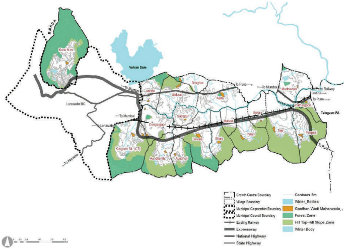
In terms of physiography, most of the area in Malavali has flat terrain with hills forming the southern boundary. The Indrayani River divides the Growth Centre into northern and southern segments. The southern part of the growth centre is covered with hills and forest. Kune N.M., Aundholi, Bhaje, Patan, Pimpaloli, Boraj villages are from the Western Ghats region. Valvan dam lies in the northwest, adjacent to the Growth Centre. The Kune NM village is separated from the remaining villages due to Lonavala Council. Hills cover 75% of the part of Kune NM, with a plateau development.
Figure 28.1: Location and Physiography
Chapter 28: Growth Centre: Malavali
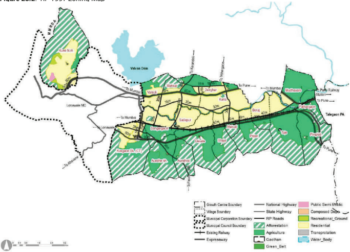
Malavali Growth Centre includes part of Sector NOR of RP 1997. It recommended a residential node in the area, and the development of tourism activities was expected. It proposed residential zoning inbetween Pune-Lonavala Railway Line and Mumbai-Bangalore Highway NH48 . It allowed built-up up to 25% in Sector NOR, with up to G+1 storey buildability.
RP 1997 proposed afforestation on existing forest lands as well as adjoining hilly barren lands. It also proposed a 30 m green belt on both side of Indrayani River.
Major transport proposal in RP 1997 includes widening of Mumbai-Bangalore National Highway. It kept 75 m RoW on each side for the tree plantation. It also proposed a 40 m wide road on the northern side of the Pune-Lonavala Railway Line. Residential areas were proposed to be linked with a network of 30 m and 18 m wide roads with the provision of level crossing and flyover.
Figure 28.2: RP 1997 Zoning Map
Table 28.1RP area Statement
Land use category
Area (ha)
Proportion of Total De-veloped Area (%)
Proportion of Total Area (%)
Residential
1920.10
82.72%
26.44%
Commercial
0.00
0.00
0.00
Industrial
0.00
0.00
0.00
Public and semi public
12.05
0.52%
0.17%
Garden, Playground and Recreation
42.37
1.83%
0.58%
Public Utility
3.64
0.16 %
0.05%
Transportation
342.97
14.78%
4.72%
Defense
0.00
0.00
0.00
Total Developed Area
2321.13
100.00%
31.96%
Agriculture
1946.14
26.80%
Afforestation
2768.98
38.13%
Green Belt
144.53
1.99%
Water bodies
81.61
1.12%
Forest
0.00
0.00
Total Undeveloped Area
4941.25
68.04%
Total Area
7262.38
100.00%
Existing Land Use
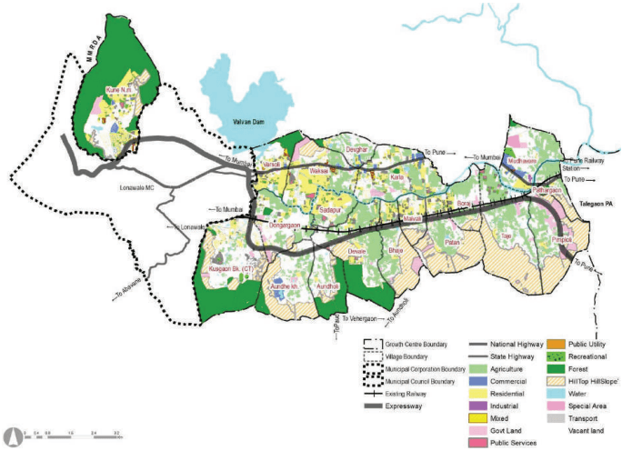
The natural beauty possessed by the Growth Centre and its strong connectivity with Pune and Mumbai has led to the development of luxury real estate in the area. The total area of the Growth Centre is 7307 Ha, with forest and hilltop hill slope combined amounting to 34% of the total area. The majority of residential developments are seen along the Mumbai-Bangalore Highway (NH-48) and around Lonavala Municipal Council. Commercial developments are also seen along the NH-48, albeit in small clusters. The total area under water body’s amounts to 2%, with the Indrayani River flowing through the central part of the GC and area under blue line is 9.35 %. Government lands are spread around in the Growth Centre, amounting to approximately 3.46 % of the total area. The majority of government lands are hilly and non-buildable.
Figure 28.3: Existing Land Use Map
Chapter 28: Growth Centre: Malavali
Table 28.2Existing Land Use Area Statement
Land use category
Area (ha)
Proportion of Total Developed Area (%)
Proportion of Total Area (%)
Residential
700.15
45.23%
9.58%
Commercial
82.85
5.35%
1.13%
Industrial
2.88
0.19%
0.04%
Mixed
16.01
1.03%
0.22%
Public and semi public
357.58
23.10%
4.89%
Garden, Playground and Recreation
76.64
4.95%
1.05%
Public Utility
2.33
0.15%
0.03%
Transportation
309.48
19.99%
4.24%
Defense
0.00
0.00
0.00%
Total Developed Area
1547.92
100.00%
21.18%
Agriculture
1297.46
17.76%
Water bodies
174.53
2.39%
Vacant Land
1806.35
24.72%
Forest
1144.55
15.66%
Hill Top Hill Slope
1320.17
18.07%
Special Areas
16.06
0.22%
Total Undeveloped Area
5759.12
78.82%
Total Area
7307.04
100.00%.
Unplanned and sporadic tourism activities
Sporadic development around Lonavala Municipal Council area, mainly along the existing roads
Residential zoning as proposed under RP 1997 has not developed due to the blueline of the Indrayani River
Absence of sewerage, storm water drainage and solid waste management sites