Hinjewadi is positioned as a “Regional Centre and IT Hub” focusing on IT/ITES, Artificial Intelligence and Robotics, leveraging its existing robust technology setup and expanding on the MIDC development in the area. It will fill the gap of a business district in the west of Pune agglomeration and complement the business requirements of the proposed IT hub. With substantial land available for development, it will cater to affordable housing and absorb high demand for commercial development that is likely to be generated by under construction Pune Metro Line 3 (Hinjewadi-Shivajinagar), PMRDA and MSRDC Ring Road and its proximity to Pune-Mumbai Expressway.
Promote IT/ITES along with Financial Services, Fintech and Blockchain activities through the development of the proposed Regional Centre at Hinjewadi.
Increase residential developments along the Regional Centre and MIDC area, promoting the work-live concept.
Cater to expected high demand for commelrcial development on account of the proposed Metro Line 3; complement business requirements of the industrial sector through a business centre.
Promote IT industrial activities by consolidating cluster development leveraging upon existing high demand around the MIDC estate.
Develop a grid network of secondary and tertiary roads for a smooth movement within the Growth Centre
Development of the proposed PMRDA and MSRDC Ring Roads stretch of 17.03 km and 10.76 km, respectively passing longitudinally through the Growth Centre
Widen SH-130 to 45 m RoW as a bypass to the existing MIDC area.
Promote residential development along PMRDA Ring Road (multimodal corridor), state highway, metro corridors, expressway and surrounding MIDC areas
Protect all the natural streams in the Growth Centre.
Establish green-blue links by connecting streams, forest and green belts of three rivers: Pawana, Khaparganga and Mula.
Promote self-sufficient town by proposing required amenities and utilities for the projected population.
Proposed Metro line extension of Hinjewadi-Shivajinagar route connecting Industrial TPS through SH-130 towards Pirangut Growth Centre
Regional Centre at Hinjewadi.
Research and development centre at Ghotawade
Trauma care centre along the YashwantraoChavan Expressway at village Gahunje
Town Planning Scheme at Hinjewadi (for implementation of Regional Centre)
Industrial Town Planning Scheme at Ghotawade along the MSRDC Ring Road and SH-130
Town Planning Scheme at Shirgaon and Gahunje along the YashwantraoChavan Expressway
Residential Town planning scheme at Marunji.
Bio-Diversity Park on government-owned land shared by Gondambare and Dhamne village.
Exihibition cum fair ground at Gahunje.
26.2Existing Situation Analysis
Hinjewadi Growth Centre falls under two talukas - Mawal and Mulshi, comprising 23 villages. Dhamne, BebadOhol,Chandkhed, Darumbare,Gahunje, Godumbare, Shirgaon, Salumbare, Sangavade villages fall under Mawal taluka. Bhoirwadi, Maan, Mahalunge (N.V.), Chande, Ghotavde, Bhegadewadi, Mulkhed, Godambewadi, Marunji, Dattawadi, Jambe, Materewadi, Nere, Hinjewadi villages fall under Mulshitaluka. The total area of Hinjawadi Growth Centre is 140.63 sq km. According to Census 2011, Hinjewadi Growth Centre population was 62,509.
Hinjewadi Growth Centre enjoys great locational advantage due to its proximity to adjoining PMC and PCMC developments, Hinjewadi MIDC/IT Park and Pune-Bangalore National Highway / Pune-Mumbai Expressway, two of the busiest transport routes in PMR. RP 1997 recognized Hinjewadi as an industrial centre with supporting residential development.
Hinjewadi Growth Centre lies in the western part of the Pune Metropolitan Region. It is surrounded by Talegaon Growth Centre and Maval taluka on the northern side, Mulshi taluka on the Western side and adjoining Pune Municipal and Pimpri Chinchwad Municipal Corporation boundary on the eastern side.
Mumbai-Pune-Bangalore Highway (NH-48) improves the connectivity of the Growth Centre with surrounding urban and rural areas. SH-130 running through the Growth Centre is the central spine between many villages as well as MIDC areas in the Growth Centre. Both MSRDC and PMRDA Ring Roads are prominent connectivity links with the entire Pune Metropolitan Region. It is convenient to reach Hinjawadi GC from Pune International Airport and the proposed airport at Navi Mumbai via Pune-Mumbai Expressway.
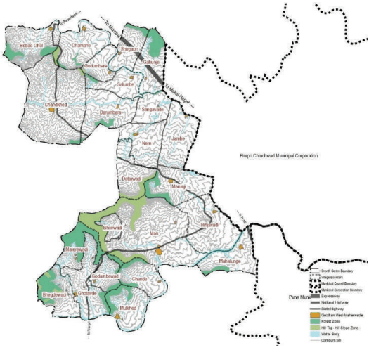
Hinjewadi Growth Centre is situated on the foothills of the Western Ghats. Most of the Growth Centre has flat terrain with subtler slopes towards the Mula River. The western hilly range in villages Mulkhed, Ghotawade, Chande, Godambewadi, Materewadi, Bhoirwadi, Man and Marunji is covered with dense vegetation under a forest area of 1093.41ha. Growth Centre lies between Pawana River in the north and Mula River in the south along with the Khaparganga River that is tributary of the Mula River itself.
Chapter 26: Growth Centre: Hinjewadi
Figure 26.1: Location and Physiography
Regional Plan 1997 Analysis
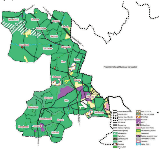
Hinjewadi Growth centre includes part of RP Sectors such as Sector PMR, Maval zone plan, B, C, and NOR. The industrial zone within Sector B was proposed for sugar factory-like development. It was also suggested to consider a new civil airport on the north of Hinjewadi between the existing westerly diversion and proposed expressway. On the other hand, sector C was envisioned to have more of residential development, considering its faster development into a residential suburb. The major industrial zone was proposed in Mann, Ghotawade and Hinjewadi villages which is majorly realised. Thus majorly IT industrial trend is observed in this Growth Centre.
The major residential zone is proposed in villages Gahunje, Marunji, Hinjawadi, Mahalunge and Chandkhed which is majorly realised. The residential zone proposed at Hinjawadi and Gahunje is observed to be accomplished, whereas the residential zone proposed at Marunji could not be implemented as it was cordoned off due to surrounding forest and industrial development. Some organised residential development is observed in the Agriculture zone surrounding 500 m of the Goathan extension.
Agriculture zone over an area of about 10418 ha dominates the Growth Centre Land Use. Weak enforcement of RP development regulations can be seen in unauthorised developments on agricultural zones near Marunji, Jambe and Gahunje adjoining existing industrial land-use and transport corridors.
Government Forest, private pad, slopes and hilly areas were proposed in the afforestation zone. Mula River, Pawana River and Kaparganga River with greenbelt and few Nalas are marked on RP 1997.
Transport network included:
PMRDA Ring Road
SH-130 with 36 m RoW
Major road grid of 36 m RoW proposed at Man and Hinjawadi
30 m regional road in Jambe, Marunji, Hinjawadi and Mulkhed villages
Figure 26.2: RP 1997 Zoning Map
Table 26.1Regional Plan Area Statement
Land use category
Area (ha)
Proportion of Total Developed Area (%)
Proportion of Total Area (%)
Residential
663.30
37%
5%
Gaothan
77.56
4%
1%
Industrial
446.42
25%
3%
Public and semi public
60.72
3%
0%
Special Economic Zone
84.79
5%
1%
Transportation
482.28
27%
3%
Total Developed Area
1815.08
100%
13%
Agriculture
10418.84
74%
Afforestation
579.90
4%
Water bodies
255.08
2%
Green Belt Zone
3.18
0%
Forest
991.26
7%
Total Undeveloped Area
12248.25
87%
Total Area
14063.33
100%
Chapter 26: Growth Centre: Hinjewadi
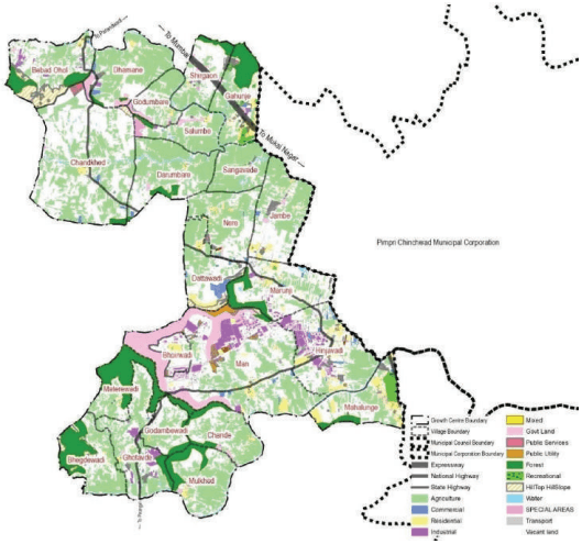
The most dominant land uses in Hinjawadi Growth Centre are Agriculture and Industrial. Industrial developments can be seen in over 2.45% of the total Growth Centre area, whereas Agricultural activities are taking place over 36.99% of the total Growth Centre area.
The major part of industrial development at Hinjawadi and Man villages fall under MIDC estate, dominated by IT activities. Industrial activity at Marunji and Hinjawadi complement the industrial activities within MIDC areas. Warehousing related activities can be seen alongside State Highway 130. MIDC Estate includes IT companies such as TCS, Wipro, Cognizant, Mahindra Tech, HCL, Dassault, KPIT, Persistent, Accenture, Capgemini, TCS, Synechron, Hexaware. SME cluster is present adjoining it, supporting engineering, paints, tools and components, consumer goods and machine parts. Hinjawadi Biotech Park includes core biotech (Emcure pharmaceuticals, Genova, Centaur, TCG, Avian Life Sciences) and ITES (Barclays, HDFC).
Residential development took place supporting the IT development and thus integrated townships such as Life Republic ITP, Xrbia Township, Blue Ridge and Riverview Township and the approved town planning scheme at Mahalunge Man have developed in the Growth Centre.
Existing public facilities such as Gahunje Stadium, Shri Chatrapati Shivaji Krida Sankul, Symbiosis International University, Alard institute, etc., are present in this Growth Centre.
Figure 26.3: Existing Land Use Map
Table 26.2Existing Land Use Area Statement
Land use category
Area (ha)
Proportion of Total Developed Area (%)
Proportion of Total Area (%)
Residential
492.43
22.18%
3.50%
Commercial
138.83
6.25%
0.99%
Industrial
345.14
15.55%
2.45%
Mixed
8.36
0.38%
0.06%
Public and semi public
701.85
31.62%
4.99%
Garden, Playground and Recreation
85.59
3.86%
0.61%
Public Utility
62.93
2.83%
0.45%
Transportation
360.09
16.22%
2.56%
Special Area
24.71
1.11%
0.18%
Total Developed Area
2,219.93
100.00%
15.79%
Agriculture
5202.46
36.99%
Water bodies
362.34
2.58%
Vacant Land
4960.29
35.27%
Hilltop hill slope
227.73
1.62%
Forest
1090.69
7.76%
Total Undeveloped Area
11843.51
84.21%
Total Area
14,063.43
100.00%
Key Challenges
Compared to the existing demand and surge in the growth of industries, transport infrastructure is not adequate. It has led to traffic congestion issues majorly along SH-130 due to encroachment and non-development of bypass/alternative route.
Existing residential development is not in line with the proposed Residential Zones in Regional Plan 1997. Instead, sporadic residential development along major transport corridors and near the Gaothan area is observed.
Significant unplanned development in agriculture zones such as unauthorized residential and industrial development is observed surrounding Gaothans in the agriculture zone.
Scarcity of water and the absence of an adequate sewage system are observed.