Kedgaon is located between Pune-Solapur Highway and the Pune-Daund Railway route. This provides a perfect setting for developing it into a “Commuter Town”, leveraging its potential for a railhead town. It is also a mid-town located over SH-118, connecting Shirur to Satara.
Promoting commercial development along the railway station to maximise the economic potential of railway land.
Maximise the economic potential of available government-owned land of 182 ha.
Effect of a bypass to SH 118 at Boripardhi village, avoiding the congestion alongside the railway station.
Increase residential zone with amenities at Kedgaon station, Kedgaon, Boripardhi and Dhaygudewadi to promote the work-live concept
Promote consolidated industrial clusters along the Pune- Solapur Highway.
Establish green-blue links by connecting forest and streams
Town Centre at Kedgaon.
Affordable housing, sports complex and cultural centre at Kedgaon.
Truck terminal at Kedgaon.
37.2Existing Situation Analysis
Kedgaon Growth Centre consists of five villages namely, Kedgaon, Kedgaon Station, Dhumalichamala, Boripardhi and Dhaygudewadi, all falling under Daund Taluka. The total area of Kedgaon GC is 2799.85 ha. According to Census 2011, Kedgaon Growth Centre population was 25,009 in 2011, and the estimated population for 2018 is 35,652.
Kedgaon Growth Centre’s key strength is it being a rail-head town along the Pune-Daund rail route, and it has good regional connectivity via NH-65 and SH-118.
Kedgaon GC is situated on the eastern side of PMR, 63 km from Pune city. Kedgaon is surrounded by Daund Taluka towards the east, Shirur Taluka towards the north, Yavat Growth Centre towards the west and Baramati Taluka towards the south-east.
Three major roads passing through the GC are Pune-Solapur Highway (NH-65), Shirur-Satara Highway (SH-118) and MDR-98.
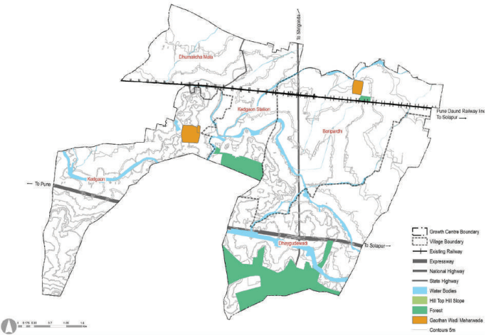
Kedgaon has plain topography with a minimal area under the hilltop hill slope. No village in Kedgaon falls under the category of the Western Ghats. Most of the settlements of Kedgaon are situated along the railway line and highways with linear development.
Figure 37.1: Location and Physiography
Regional Plan 1997 Analysis
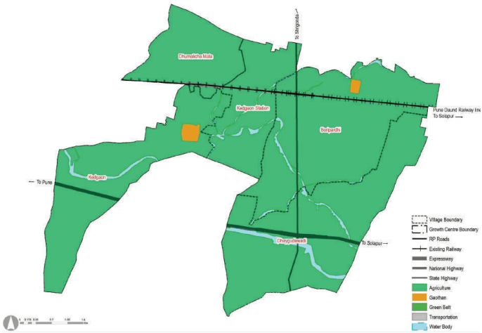
This Growth Centre was not part of any urban sector of RP 1997. The entire area was proposed for agricultural activities.
Table 37.1Regional Plan 1997 Zone Area Statement
Land use category
Area (ha)
Proportion of Total Developed Area (%)
Proportion of Total Area (%)
Residential
20.47
72.82
0.73
Commercial
0
0.00
0.00
Industrial
0
0.00
0.00
Public and semi public
0
0.00
0.00
Garden, Playground and Recreation
0.00
0.00
Public Utility
0
0.00
0.00
Chapter 37: Growth Centre: Kedgaon
Transportation
7.64
27.17
0.27
Defense
0
0.00
0.00
Total Developed Area
28.11
Agriculture
2666.93
96.22
95.25
Water bodies
104.82
3.78
3.74
Green Belt
0
0.00
0.00
Hill_Top_Hill_Slope
0
0.00
0.00
Forest
0
0.00
0.00
Total Undeveloped Area
2771.75
Total Area
2799.86
Figure 37.2: RP 1997 Zoning Map
Existing Land Use
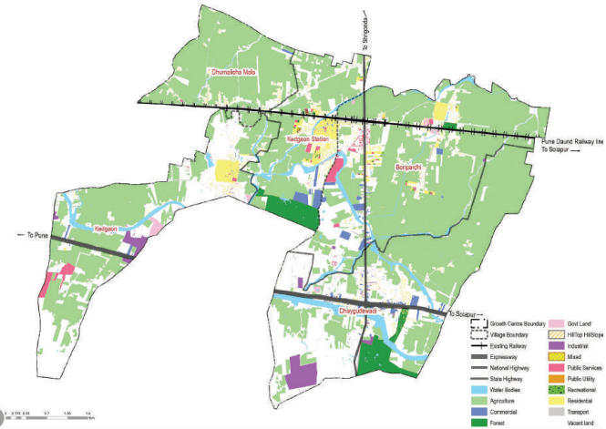
The most dominant land use in Kedgaon Growth Centre is Agriculture, which covers 1,510 hectares. There is minimal residential development currently in this Growth Centre. Brick-kilns are found along the highways with few dotted industrial developments.
Figure 37.3: Existing Land Use Map
Table 37.2Existing Land Use Area Statement
Land use category
Area (ha)
Proportion of Total Developed Area (%)
Proportion of Total Area (%)
Residential
67.98
22.51
0.82
Commercial
28.92
9.58
1.05
Industrial
38.4
12.72
1.40
Public and semi public
127.39
42.18
4.65
Garden, Playground and Recreation
2.91
0.96
0.11
Special Area
1.63
0.54
0.06
Public Utility
0.93
0.31
0.03
Transportation
35.45
11.74
1.29
Defense
0
0.00
0.00
Total Developed Area
301.98
Agriculture
1568.13
55.08
Water bodies
113
4.12
Vacant Land*
665.41
24.27
QUARRY
0
0.00
Chapter 37: Growth Centre: Kedgaon
Forest
151.34
5.52
Hill Top Hill Slope
0
0.00
Total Undeveloped Area
2439.87
98.40
Total Area
2799.86
Traffic congestions along the MDR-98 crossing a railway station
Critical junctions: NH-65 and SH-118 junction
Scattered development in Kedgaon Station
Absence of sewerage, stormwater drainage and solid waste management sites