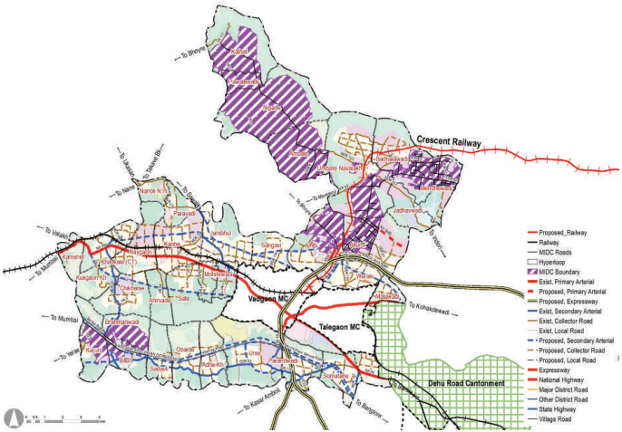
Key strengths of the Growth Centre are its salubrious climate, strong industrial development at Talegaon MIDC and robust regional access by Mumbai Bangalore National Highway, Lonavala-Pune Railway, and Yashwantrao Chavan Expressway. It has been attracting large automobile industries such as General Motors, Mahindra, JCB, POSCO and MSMEs at Floriculture Park.
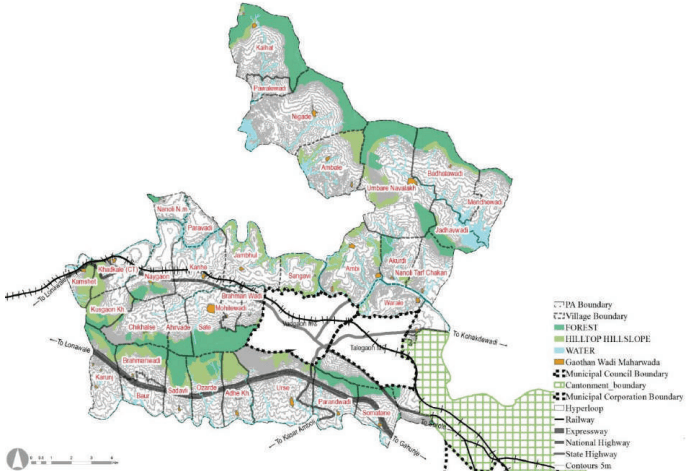
Talegaon Growth Centre is located at the North-west of PMR, 28 km away from Pimpri Chinchwad. It enjoys strong regional connectivity with major transit corridors such as Mumbai-Bangalore National Highway (NH-48), Lonavala-Pune Railway, Yashwantrao Chavan Expressway passing through the Growth Centre.
It is surrounded by Talegaon Dabhade and Vadgaon Municipal Councils on its eastern boundary. Chakan Growth Centre abuts it on the East, Malavali Growth Centre on the West and Pawana River on the South. It is connected to Chakan and beyond by a national highway (NH-548D). Its future connectivity is likely to be strengthened by the proposed PMRDA Ring Road, quadrupling of Lonavala-Pune Railway Line and Cresent as well as Mumbai – Hyderabad high speed Railway Line.
Talegaon Growth Centre’s terrain is gradually sloping towards the south where Indrayani River is located. Andra Dam, Indrayani River and southern ridge (forest zone) split Talegaon GC into three parts.
Indrayani River flows through the Growth Centre in addition to its tributaries, with Sudha River being the major one. In contrast, the Pawana River flows along the southern edge of the Growth Centre. Forest areas are situated on the East, West and North side of the Growth Centre.
Figure 27.1: Location and Physiography
Chapter 27 Growth Centre: Talegaon
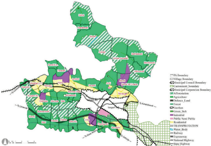
Talegaon Growth Centre includes part of RP 1997 Sectors such as Sector NOR, J and Maval Zone Plan. Residential Development has been majorly proposed to the along old Mumbai – Pune Highway and partially along expressway.
Industrial area is also proposed at Kanhe, Urse, Akurdi and Chikhalse village.Chikhalse village has been earmarked for industrial purpose with a view to provide job opportunities to local people.
RP 1997 proposed widening of Mumbai - Pune highway i.e. 60 m. with 45 m Green Belt on either side for tree plantation. , ensuring a 75 m setback from the centreline of the highway. (No construction activity is allowed in Green Belt), 40M wide diversion through Khadakale, Kusgaon Kh. And Chikhalse and Ahirwade and further connecting to the Highway near C.R.P.F. in Talegaon Growth Centre and 40 M wide Northern and Southern diversion.
Figure 27.2: RP 1997 Zoning Map
Table 27.1RP 1997 Area Statement
Land use category
Area (ha)
Proportion of Total Devel-oped Area (%)
Proportion of Total Area (%)
Residential
2103.87
53%
10%
Gaothan
101.86
3%
0.5%
Industrial
931.91
23%
5%
Public - Semi Public
186.33
5%
1%
Transport
653.61
16%
3%
Total Developable Area
3977.6
100%
19%
Agriculture
10654.91
52%
Forest
381.85
2%
Defence
53.56
0.3%
Afforestation
4922.45
24%
Green Belt
178.13
1%
Waterbody
325.51
2%
Total Non Developable Area
16516.45
81%
Total
20494.05
100%
Existing Land Use
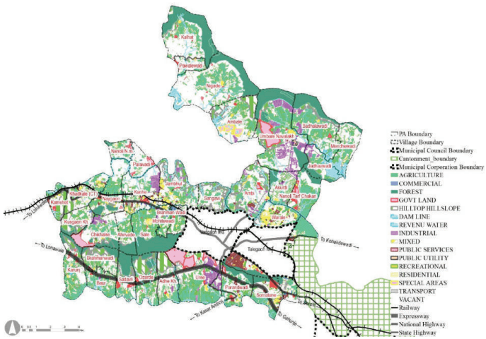
Industrial developments have been flourishing in the Growth Centre along the Mumbai-Bangalore National Highway and Yashwantrao Chavan Expressway due to its proximity with PMC and Chakan MIDC. Agriculture (24.76%), Forest (13.37%) and Hilltop Hill slope (7.82 % ) shares maximum land uses in the GC.
Talegaon Growth Centre’s total area is about 20491 Ha., out of which 11% land is developed. It includes residential, commercial, industrial and allied uses. Public semi-public use (about 4.59%) is the largest among developed areas, including major educational institutess such as the National Institute of Post-Harvest Technology, DY Patil Engineering College, Heritage Residential School, Empress International School. Developed areas are clustered at villages such as Khadkale, Kanhe, Jambhul, Ambi, Warale and Somatane.
Figure 27.3: Existing Land Use Map
Chapter 27 Growth Centre: Talegaon
Table 27.2Existing Land Use Area Statement
Land use category
Area (ha)
Proportion of Total Devel-oped Area (%)
Proportion of Total Area (%)
Residential
500.44
19%
2.44%
Gaothan
99.15
4%
0.48%
Commercial
89.04
3%
0.43%
Industrial
498.75
19%
2.43%
Public semi Public
939.77
35%
4.59%
Transport
521.38
19%
2.54%
Mixed use
17.70
1%
0.09%
Public Utilities
22.22
1%
0.11%
Total Developed Area
2688.45
100%
13.12%
Agriculture
5073.60
24.76%
Forest
2739.47
13.37%
Hilltop Hill slope
1603.55
7.82%
Special areas
120.48
0.59%
Recreational
49.74
0.24%
Water Body
684.11
3.34%
Vacant Land
7534.52
36.76%
Total Non-Developed Area
17805.46
86.88%
Total Area
20493.92
100%
Key Challenges
Traffic congestion along NH-48 and NH-548D, as no bypass developed
Absence of sewerage, storm water drainage and solid waste management sites.
Industrial growth has been depleting the air quality in the region, considering the rapid unorganized urbanization of Talegaon GC.
Chapter 27Growth Centre: Talegaon
27.1 Summary
Talegaon is envisioned to be developed into an “Industry 4.0 Hub”. The primary reason to assign this economic role to Talegaon is to leverage the established automobile and engineering industrial ecosystem at Talegaon MIDC. Further, the Growth Centre enjoys locational advantage with robust regional connectivity through major transit corridors such as Pune-Mumbai Expressway, Pune-Bangalore National Highway, Pune-Lonavala-Mumbai Railway Line and proposed PMRDA and MSRDC Ring Road.
Develop ecosystem for “Industry 4.0 Hub” by envisaging three development corridors:
a. First corridor: industrial corridor capturing planned expansion of Talegaon MIDC and served by proposed Crescent Railway (serving mainly freight logistics to Growth Centres having industrial character)
b. Second corridor: transit conversant residential developments along the Pune-Mumbai rail route with two employment nodes at Kanhe (unimplemented industrial cluster as per RP 1997) and Jambhul and Mohitewadi (new commercial cluster).
c. Third corridor: residential corridor spanned along the Pune-Mumbai Expressway recognising upcoming township developments alongside and complemented by two employment nodes at Urse.
Promote logistic and warehousing activities by consolidating cluster development leveraging existing strong regional connectivity that will be further enhanced through a slew of major infrastructure projects in the areas such as Ring Roads, Pune-Hyderabad Railway.
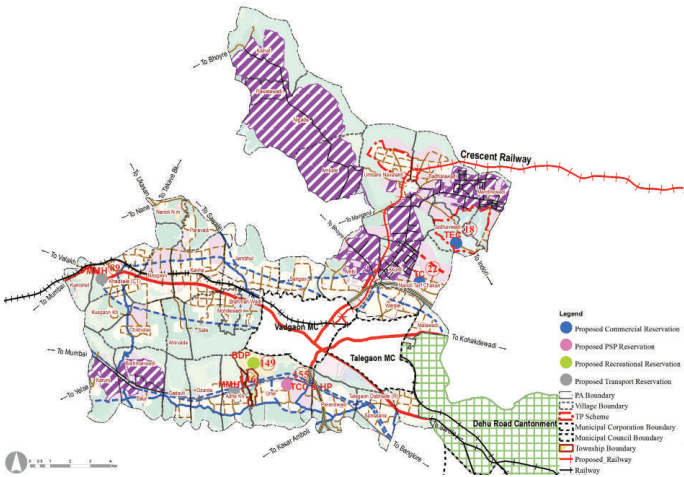
Development of a multi-modal hub (MMH) at Mohitewadi that will connect Mumbai-Bangalore National Highway (NH-48) and the existing railway line (Pune-Lonavala Line) and another two MMH at Adhe Kh and Khadkale CT near Mumbai – Pune Expressway.
Town Centre at Nanoli tarf Chakan (15.51ha)
Trauma Care Hospital and Helipad at Urse (1.54 ha) and Naygaon (1.05 ha)
Multimodal Hub at Adhe Kh (3.34 ha) and Khadkale CT ( 2.02 Ha.)
Biodiversity Park at Urse (166.79 Ha)
Tourist Entertainment Centre near Jadhavwadi Dam ( 52.84 Ha)
2 Town Planning Schemes are proposed . One is at Umbare Navlakh and Badhalwadi (237. 08Ha) and second one is at Jadhavwadi near Jadhavwadi dam (452.58 Ha.)
27.4Proposed Reservation Statement, Costing and Phasing
Table 27.10Proposed Reservation Statement
Sr.
Purpose of Reservation
Planning Standard
Total Require-ment
Existing/Available
Proposed reservations
Total Reserva-tions
Area
Min. unit required
No. of sites
Area in Ha
No. of sites
Area in Ha
No. of Sites
Area in Ha
No. of sites
Area in Ha
Neighbourhood Level
1
Primary School I - V
0.4 ha including playground.
1/500students
51
20.3
55
8.1
9
7.20
64
15.3
1/5000population
2
Secondary VI - XII
1 Ha. / site (0.6 ha for play ground and 0.4 ha for building )
1/1000students
25
25.4
24
2.5
7
6.80
31
9.30
1/10000population
3
HealthCentre
0.08 - 0.12 Ha
1HC / 15,000 population
17
2
7
2.2
14
1.72
21
3.92
4
Community Hall
0.2 ha/ site
1 /15,000population
17
3.4
0
0
12
3
12
3
5
Garden
1 Ha
1/15000population
17
16.9
1
1.1
26
17.17
27
18.27
6
Playground
1.5Ha
1/15,000population
17
25.4
1
1.6
22
20.96
23
22.56
7
Shopping Centre/ Market
0.3- 0.45 Ha
1/15,000population
17
7.8
0
0
9
5.34
9
5.34
8
College
5 Ha
1000 - 1500students
2
10
12
77.08
0
0
12
77.08
1/1.25 lakh population
9
Hospital/ Trauma Care Centre
Cat A = Area-3.70 Ha
1/100,000population
3
3
0
0
3
3.55
3
3.55
200 beds, Cat B = Area =1 Ha., 80 beds
10
Public Housing
_
_
0
0
0
0
6
40.25
6
40.25
11
Cultural Centre/ Social Welfare Centre/Socio-Cultural Centre
0.6-1 Ha.
1/ 1Lakh
3
3
0
0
3
2.28
3
2.28
12
Town Park
3- 5 Ha.
1 / 1 lakh
3
15
0
0
1
3.53
1
3.53
13
Sports complex
3- 5 Ha.
1 / 1 lakh
3
6
0
0
4
21.12
4
21.12
Chapter 27 Growth Centre: Talegaon
Sr.
Purpose of Reservation
Planning Standard
Planning Standard
Total Requirement
Total Requirement
Existing/ Available
Existing/ Available
Proposed reservations
Proposed reservations
Total Reserva-tions
Total Reserva-tions
Sr.
Purpose of Reservation
Area
Min. unit required
No. of sites
Area in Ha
No. of sites
Area in Ha
No. of Sites
Area in Ha
No. of sites
Area in Ha
14
Fire Brigade station
0.4 Ha.
As per requirement of Fire department of PMRDA. 1 Fire station / growth centre
1
0.4
0
0
1
0.46
1
0.46
15
Burial ground
4 Ha.
1 site/ 5 lakh,
1
2.02
0
0
1
1.12
1
1.12
16
Cremation ground
2.5 Ha
1 site/ 5 lakh,
1
1.26
21
0.76
8
1.18
29
1.94
17
Solid Waste Management Site
5 Ha . (As per land availabili-ty)
1 site per growth centre
1
5
0
0
4
10.35
4
10.35
18
Sewerage treatment plant
80% of water supply may be expected to reach the sewers
Land area requirement is as per URDPFI i.e. For activated Sludge Process (ASP)-0.15 Ha/MLD
1
3.47
0
0
6
2.91
6
2.91
19
Water works (Water treatment Plant, tanks & pipes)
Land area requirement is as per URDPFI i.e. 1) 5MLD- 0.10 Ha 2) 10MLD- 0.19Ha 3) 50MLD- 0.93 Ha 4) 100MLD- 1.87Ha 5) 200MLD- 3.73Ha 6) 500MLD- 9.34Ha
Water requirement of PMR is 72 lpcd as per Report 'Integrated Master Plan Of Water Sup-ply, Sewerage, Storm Water and Solid Waste Management in the PMR'. It is distributed to each Growth center.
1
0.48
2
0.8
2
1
4
1.8
20
Effluent Treatment Plant
-
-
-
0
0
2
1.62
Table 27.11Cost and Acquisition Statement for Proposed Reservations
Cultural Centre/ Social Welfare Centre/ Socio-Cultural Centre/ Community and cultural centre
35, 81, 163
14
Town Park
34
15
Sports complex
39, 75
51
145
17
Fire Brigade station
123
18
Burial ground
13
19
Cremation ground
41
76, 98
112, 125, 142
132, 136
20
Solid Waste Management Site
91
1
115, 133
21
Sewerage treatment plant
40, 70, 72, 87,152, 169
22
Water works (Water treatment Plant, tanks & pipes)
116
150
23
Effluent Treatment Plant
14, 80
24
Town Centre
22
25
Government Purpose
73
26
Bus Depot
124
27
Police Station
122, 154
28
Bio Diversity Park
149
29
Tourist Entertainment Centre
18
30
Multi Modal Hub
89
146
31
Railway Station
12
32
Truck Terminal
160
33
APMC, Khadkale Upaba-zar,Talegaon Dabhade.
106
34
District Court
21
35
Warehouse
111
Chapter 27 Growth Centre: Talegaon
Total Cost of development of Reservations of UGC : Talegaon
Total Acquisition cost of Reservations ( in Rs.CR.)
Total Construction cost of Reservations ( in Rs.CR.)
Total Cost of development of Reservations( in Rs.CR.)
Road construction cost
Total Development Cost
Reservation on Amenity Space/TP scheme/Government (A)
0.00
3457.22
3457.22
2530.00
6513.11
Reservations on Private land
260.00
791.78
1051.78
50% of the total cost of reservations on private land with an assumption that 50% of reservations will be developed through TDR/AR & In-situ FSI (B)
130.00
395.89
525.89
Total Cost (A+B)
130.00
3853.11
3983.11
Chapter 28: Growth Centre: Malavali
27.3Proposed Role and Strategies
Talegaon Growth Centre is envisioned as an ‘Industry 4.0 Hub’. The rationale behind assigning this role to Talegaon is:
Established automobile and engineering industrial environment at Talegaon MIDC
The proposed expansion of MIDC estate on 2,200 ha land (Talegaon MIDC Phase 4, 5) and anticipated growth drivers such as electric vehicles (EV), digitization and automation
Presence of leading educational institutes
Excellent accessibility utilizing Yashwantrao Chavan Expressway, Mumbai-Bangalore National highway, proposed quadrupling of Lonavala-Pune Railway Line , Crescent and Mumbai – Hyderabad High Speed Railway and proposed PMRDA and MSRDC Ring Road.
Considering the above, industrial zoning is proposed at near existing/planned MIDC estates about 1770 Ha. The MIDC as well as industrial zones are meant to promote Renewable Energy, AI and Robotics, IOT, High Tech Engineering and Defense Equipment Manufacturing.
Table 27.3Population Projections
Village
2011
2018
2031
2041
Adhe kh.
943
1,055
5,626
10,181
Ahirvade
991
1,274
1,822
2,377
Akurdi
184
389
491
509
Ambale
1,550
2,280
4,073
5,967
Ambi
2,328
4,681
9,944
15,466
Badhalawadi
1,202
1,866
2,680
3,392
Baur
1,207
1,391
1,537
1,642
Brahman Wadi
1,549
1,777
1,952
2,078
Brahmanwadi
834
880
849
831
Chikhalse
1,524
2,376
2,728
2,771
Jadhavwadi
632
840
1,330
1,860
Jambhul
1,794
11,045
15,174
15,388
Kalhat
1,009
1,129
1,195
1,244
Kamshet
828
1,650
2,043
2,110
Kanhe
4,707
13,729
18,166
18,859
Karunj
1,722
1,956
2,117
2,235
Khadkale (CT)
13,435
34,971
75,400
1,14,511
Kusgaon Kh.
1,112
2,965
4,601
5,675
Malawadi
-
-
-
-
Mendhewadi
861
1,179
1,995
2,893
Mohitewadi
778
802
740
702
Nanoli N.m.
454
519
566
600
Nanoli Tarf Chakan
983
1,086
1,127
1,160
Nayagaon
1,782
3,954
4,955
5,083
Nigade
1,610
1,790
1,877
1,943
Ozarde
981
1,063
1,072
1,082
Parandvadi
2,317
4,611
7,244
9,362
Paravadi
379
438
487
522
Pawalewadi
346
356
329
312
Sadavali
590
663
708
741
Sangavi
625
866
968
990
Chapter 27 Growth Centre: Talegaon
Sate
1,772
2,603
3,102
3,297
Somatane
5,300
14,131
22,316
27,761
Talegaon Dabhade (R)
7,373
10,821
13,622
15,107
Umbare Navalakh
3,064
4,638
5,448
5,681
Urse
3,635
4,482
13,606
22,468
Varale
7,202
23,296
34,765
40,239
Total
77603
163552
266655
347039
The projected resident workforce based on the projected population through the URGD method is 1,28,527. Considering the proposed economic activities of all the growth centres, employment distribution was proposed based on the envisaged sectoral split for that Growth Centres. Accordingly, the employment to be generated for the Growth Centre for the year 2041 is estimated to be 3,19,669. The proposed residential density is about 125 PPH (12,500 persons/sq km).
For the planning of public facilities distribution, Talegaon Growth Center is divided into four sectors. The boundaries of this planning division are shown on the Proposed Zoning Map. The projected sector-wise population statement is in Table 27.3.
Table 27.4Projected Population - Sectors
Sector
2011
2018
2031
2041
Sector 1
22301
60713
86916
99210
Sector 2
20126
47707
92115
133127
Sector 3
24902
41054
68697
91410
Sector 4
10274
14077
18927
23293
Total
77603
163551
266655
347040
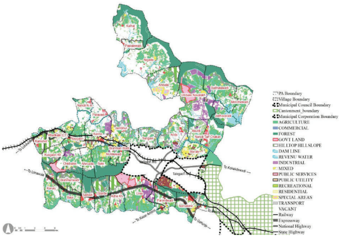
The proposed zoning would guide and determine the optimal and efficient land use for the next 20 years. The proposed zoning plan is an output of existing land use and physical conditions analysis, understanding of most pressing issues of the Growth Center, local knowledge of the place and deployment of five planning goals and allied physical planning strategies. The proposed zoning area statement is presented in Table 27.4.
Figure 27.4: Proposed Zoning Map
Table 27.5Proposed Zoning Area Statement
Land Use Category
Area (ha)
Proportion of Total De-veloped Area (%)
Proportion of Total Area (%)
Residential
4175.55
34.22%
20.37%
Gaothan
84.43
0.69%
0.41%
Commercial
327.74
2.69%
1.60%
Industrial
1620.85
13.28%
7.91%
MIDC
4309.57
35.32%
21.02%
Logistic
144.70
1.19%
0.71%
Public semi Public
336.95
2.76%
1.64%
Transport
1181.37
9.68%
5.76%
Public Utilities
21.76
0.18%
0.11%
Total Developable Area
12202.92
100%
59.52%
Agriculture
2718.25
13.26%
Forest
3040.27
14.83%
Hilltop hill slope
913.11
4.45%
Afforestation
17.53
0.09%
Tourism Development
241.94
1.18%
Chapter 27 Growth Centre: Talegaon
Green Belt
564.42
2.75%
Recreational
235.53
1.15%
Defence
8.64
0.04%
Water Body
560.56
2.73%
Total Non-Developable Area
8300.25
40.48%
Total
20503.17
100%
Translating Goals into the Plan
Proposed zoning ensures that the sectoral development goals are clearly conveyed through it. Proposed sectoral goals and their corresponding physical planning strategies are mentioned in Table 27.5.
Table 27.6Goals and Physical Planning Strategies
Goals
Development Sector Addressed
Physical Planning Strategies
Prudent
Employment and housing
Work- Live Hubs
Convenient
Roads and mass transport
Movement Lattice
Resilient
Environment protection
Green- Blue connectors
Efficient
Infrastructure and utilities
Decentralized resource management
Self- sufficient
Social facilities
Walkable Neighbourhoods
For Talegaon Growth Center, the Work-Live concept is applied by:
Designating residential zones within 500 m around industrial, logistics and commercial zones to minimize work-related trips for at least 30% of the resident workforce
Allocating industrial, logistics, and commercial zones along the proposed mass transit corridors to reduce travel time for workforce commuting from other Growth Centers.
Out of the total proposed industrial zone of 18860 Ha., 5600 Ha.of industrial development is envisaged at Talegaon growth centre, based on 50 workers/Ha. Thus considering the existing scenario of industrial development, the strategic infrastructure proposals and planning intent of Regional Plan, 5930.43 ha. of industrial zone is proposed. The Development Plan intent is to allow expansion of industrial development near existing MIDC and devloped industrial area with consideration of good connectivity to industrial hubs.
The total logistic land use requirement of the Study Area is estimated to be 2020 Ha.considering projected demographics and area requirement of 55 sqm built-up area per person. 100 Ha. of this estimated area is anticipated in Talegaon Growth Centre. However, considering the proposed role of the GC, the prevailing trend of warehousing and supplementary industries and the proposed strategic infrastructure projects, logistic use is proposed over 144.70 Ha.
This zone, being proposed at the junction of NH 548 D and MDR 15 in Ambi village , at the junction of Yashwantrao Chavhan Expressway and MSRDC ring road as well as in Badhalwadi along the Cresent railway.
Land requirement for the residential zone is estimated based on a net residential density of 125 PPH. Further, 45% add-on is considered to account for amenity (15%), open spaces (10%) and roads (20%). Accordingly, the total gross area required for the projected GC population of 3,21,195 by 2041 is estimated to be 3830 Ha.
The total population of ITP in the Growth Centre is 25,845, while the projected population for the rest of the Growth Centre area is 3,21,195 Accordingly, the total gross area required for the total projected GC population of 347,040, is estimated to be 3830 Ha.
Considering the projected population, net residential density, proposed role and existing growth trends within the Growth Centre, 4175.55 Ha. of gross residential zone is proposed.
As per the Work Live hub concept, by understanding the current mature consolidated residential zoning is proposed in the Growth Centre. Town Planning Schemes are proposed at Umbare Navlakh, Badhalwadi and Jadhavwadi.
Land requirement for the commercial zone is estimated based on URDPFI guidelines, i.e. 0.6 ha per 1,000 population. Add on of 30% is considered to account for roads (15%), open spaces (10%) and amenities (5%). Accordingly, the total commercial zone requirement for the Study Area is estimated to be 2377 Ha. 251 Ha. from this area is estimated for growth centre and 327.74 Ha. is proposed in the Growth Centre such that equitable distribution of commercial activities is facilitated.
Six cardinal commercial nodes are proposed, one at the junction of Lonavala – Pune Railway line and NH-48, Second one is along NH 48 near Talegaon Dabhade ,other three are along Yashwantrao Chavhan Expressway Near Sadavali, Ozarde, Urse and one is at Umbare Navlakh. Town Centre is proposed at Nanoli Tarf Chakan.
The movement lattice concept also includes a mass transit corridor running through the Growth Center centre, high-speed rail crossing the Centre and Ring Road to encourage >50% of the residents to use mass transport for their daily commute.
A parallel road system (30 m wide) to Pune-Bangalore National Highway is proposed on its Southern and Northern sides. It will bypass the congested sections along Khadkale, Nayagaon, Kanhe, Mohitewadi and Brahmanwadi and disconnect it from local traffic. This bypass development should be on topmost priority of the Growth Centre.
Similarly, a Northern bypass to Vadgaon MC and Talegaon MC is proposed through another secondary link.
Widening of MDR-103, MDR-104, MDR-108, MDR-15, MDR-157, MDR-22, MDR-78, MDR-88, ODR-57, ODR-61 and ODR-63 is proposed and should be taken on priority followed by existing village roads.
Talegaon Growth Centre is connected to Hinjawadi Growth Centre via SH-130 and SH-55. Hence, widening of these roads to 45 m width is proposed.
Grid-iron pattern of collector roads (15-24 m wide) is proposed in the Growth Centre, covering all the residential areas.
Collector roads (15-24 m wide) follow spacing of 300-500 m. Secondary arterials (30-45 m wide) follow a 1 to 2 km grid pattern, covering the entire residential zone.
Secondary arterials have the flexibility to run a dedicated bus service for faster transport and support the feeder system and last-mile connectivity.
Chapter 27 Growth Centre: Talegaon
Table 27.7Proposed Transport Network Statement
Road Category
Road names/ ROWs
Proposed ROWs
Authority
Total Length (km)
Total road development cost(INR Cr)
Primary
Expressway
90
NHAI
17
NH 48
60
NHAI
17
NH 548 D
60
NHAI
2.1
Secondary
SH 55
45
PWD
0.87
SH 126
18
PWD
2.36
SH 130
45
PWD
4.22
Tertiary
MDR15
60
PWD
3.73
MDR 2
30
PWD
3.22
MDR 22
36
PWD
3.5
MDR 57
24
PWD
0.32
MDR 78
30
PWD
1.52
MDR 88
30
PWD
6.7
MDR 100
24
PWD
0.47
MDR 103
24
PWD
7
MDR 104
36
PWD
3.31
MDR 108
24
PWD
0.16
MDR 157
30
PWD
1.2
ODR 61
24
ZP
3.43
ODR 63
30
ZP
3.22
Local
VR (Total)
15,18
ZP
18.39
Primary
MSRDC Ring Road
110
MSRDC
11.16
-
PMRDA Ring Road
65
PMRDA
0.55
28.89
NH 548 D
60
PMRDA
2.95
127.84
Secondary
36
PMRDA
25.73
923.81
30
PMRDA
39.22
901.80
Tertiary
24
PMRDA
20.12
379.89
18
PMRDA
69.94
51.81
15
PMRDA
45.38
42.24
Local
12
PMRDA
5.84
69.06
9
PMRDA
0.57
5.37
Total Road Length
321.18
2530.71
Figure 27.5: Proposed Transport Network Map
Resilient: Green-Blue Connector
The existing forest areas on the west of Vadgaon Municipal Council and North of MIDC Phase 4, 5 are designated as protected areas.
Green Belt is proposed between the river bank and the corresponding blue line for Pawana, Indrayani and Sudha Rivers.
All existing streams and water reservoirs to be protected.
Green lungs are proposed within 500 m walkable distance covering an area of 830.21 ha. These green lungs include active and passive recreational spaces. The total active recreational space works out to be 46.68ha that include playgrounds, sport complex, stadium and multi-purpose ground. And the total passive recreational space works out to be 766.52 ha that include gardens, town park/ regional park, bio diversity park and green belt.
The realisation of the ‘Efficient’ goal would mean successful management of natural resources and implementation of proposed infrastructure network as well as utility sites covering 100% projected population of a Growth Centre. These networks are proposed to be integrated systems using smart metering, renewable energy and SCADA systems. The goal would cover infrastructure systems such as water supply, wastewater, storm water, electricity and solid waste management systems.
Chapter 27 Growth Centre: Talegaon
This concept is applied as follow:
2 water treatment plants (1 ha) is proposed at Nayagaon and Urse.
6 Sewage Treatment Plant (2.5 ha) is provided for the Growth Centre and is located at Jambhul, Urse, Khadkale CT, Akurdi, Nanoli N.M, Somatne away from the residential development.
Solid Waste Management sites (9.24 ha) are provided at Kamshet and Umbare Navlakh.
2 effluent treatment plants (1.11 ha) is proposed at Nayagaon and Badhalwadi
Table 27.8Proposed Infrastructure Demand
Infrastructure System
Demand (2041)
Unit
Required Area(Ha.)
Utility Sites
Total Area
Water Supply
25.14
MLD
0.48
2 WTP
1
Sewerage
24.99
MLD
3.47
6 STP
2.5
Solid Waste
104.11
Tones/day
5
4 SWM
10.35
Effluent Treatment Plant
_
_
_
2ETP
1.62
This goal is set to increase the liability index of the Growth Centre. To do that, amenities are proposed within 500 m distance, leveraging the concept of Walkable Neighbourhoods. The concept entails providing basic infrastructure and services for education, health, sports, and recreation within the neighbourhood to have easy access to them by foot.
Amenity provision is made for the projected population by 2031 (2,53,732 people)
Neighbourhood level amenities are located within a 500 m. radius from residential zones and are connected by collector/local roads to improve their accessibility from other neighbourhoods.
Town level amenities are distributed across the Growth Centre and are accessible by mass transit modes such as bus system, railways.
Education: Talegaon Growth Centre is one of the largest growth centres in PMR. Therefore five primary schools, three secondary schools and four primary + secondary schools are proposed. Wherever possible, expansion to the existing ZP schools is proposed with proper road access to each amenity.
Health: A trauma care centre is proposed along the NH-48 at Urse. 2 general hospitals and 14 healthcare centres are proposed spatially distributed all over the growth centre.
Socio-Cultural: Community halls are provided considering walking distance within a neighbourhood. One cultural centre, one socio-cultural centre and one social welfare centre and 12 community halls are proposed.
Open Space: Playgrounds are located near schools and are split into 2 with a minimum area of 0.8 ha to improve spatial distribution wherever required. Total of 22 playgrounds and 26 gardens are proposed. At town level, 1 town park and 4 sports complexes are proposed. One Biodiversity park is proposed at the regional level.
Commercial: Shopping Centre/market is provided at existing commercial nodes or near existing settlements or on available amenity spaces. Proposed four markets and five shopping centres would serve the entire growth centre. As Talegaon growth centre comprises 37 villages, considering the whole spread, a town centre over 15 ha is proposed.
Residential: Public housing of 3.57 Ha. area is provided at Parandwadi and Talegaon Dabhade villages as per MHADA requirements and another 14.37 Ha. public/ affordable housing is proposed at Nanoli Tarf Chakan and Malwadi village serving the adjoining industrial / commercial activities.
Transport: Two Multimodal Hubs are proposed within the growth centre, along the NH-48 and Yashwantrao Chavhan Expressway. One truck terminal is proposed in Parandwadi and Urse village. At Badhalwadi , railway station has been proposed for Cresent Railway and one Bus Depot is proposed at Kanhe of 1.11 Ha.
Civic: A fire station is provided in Paravadi village Existing crematorium and burial grounds are maintained and expanded wherever required and feasible.
Civic facilities requested by various government authorities: Two police station and one district court are reserved based on requirements from the concerned authorities. Further, based on APMC, Talegaon Dabhade and Maharashtra State Warehouse Corporation requirements, APMC market and warehouse are proposed in Khadkale CT.
Table 27.9Summary of Land Ownership of Proposed Amenities
Land Ownership
No of Amenity
Total Area (ha)
Government Land
37
269.66
Private Land
98
88.82
Amenity Space
31
16.76
Handover Amenity
1
0.12
Trust
4
3.89
Other
7
58.00
Total
178
437.24
Town Planning Scheme: PMRDA envisages implementing the Development Plan proposals by enabling the provision of Town Planning Schemes, which will considerably reduce liability towards the direct cost of acquisition of land required for social and physical infrastructure. Two TPS within Talegaon Growth Centre are proposed, one at Umbare Navlakh and Badhalwadi and the second at Jadhavwadi near Jadhavwadi Dam.
The reservations proposed to be developed using the TPS mechanism are as follows: a. Strategic Projects : Tourist Entertainment Centre
b. Amenities: Primary and Secondary Schools, Playgrounds, community hall, Gardens
The other proposals/reservations of the Development Plan are proposed to be acquired and developed through the mechanism of Accommodation of Reservation and Transfer of Development Rights (TDR) policy. It is estimated that all proposed roads and 50% of the public reservations will be acquired through TDR/FSI/ AR.
The remaining reservations will be acquired under the provision of the Land Acquisition Act by paying monetary compensation.