Shikrapur Growth Centre is envisioned as a Logistics and Industrial Hub, leveraging its strategic location along the Aurangabad-Chakan-JNPT industrial corridor (NH-548D) and existing industrial cluster in Sanaswadi. Pune-Ahmednagar Highway (NH-753F) and the proposed Crescent railway line for cargo use will act as a catalyst to realize the proposed economic positioning. Its proximity to Wagholi and PMC as well as mass connectivity through the proposed Metro route (Ramwadi-Wagholi-Shikrapur) will further add to the ease of commute.
Promote logistic and warehousing activities by consolidating cluster development, leveraging upon existing high demand along Pune-Ahmednagar Road and capitalising on the Crescent Railway and Metro corridor (Ramwadi-Wagholi-Shikrapur)
Promote Work-Live hub concept by increasing residential development adjacent to existing industrial activities
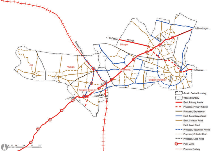
Develop bypasses to primary roads for avoiding congestion due to logistic activities at Sanaswadi
Develop a grid network of secondary and tertiary roads for a smooth movement within the Growth Centre
Develop tourism activity along the Bhima River in proximity to Tulapur
Establish green-blue links by connecting forest and green belts of Bhima River, Velu River, Chaskaman left bank canal and existing streams with green avenues
Promote self-sufficient town by proposing required amenities and utilities for the projected population
Crescent Railway and Station at Vadhu Bk (18.12 ha)
Logistic Hub at Vadu Bk (99.6 ha)
Metro line (Ramwadi-Wagholi-Shikrapur) and Metro Depot at Vadu Bk (17.15 ha)
Integrated development of Town Centre (15.37 ha) and Multimodal Hub at Vadu Bk (9.63 ha)
Town Planning Scheme themed as a logistic park at Vadu Bk (295 ha)
Spiritual Tourism Hub at Apti (23.87 ha)
Cultural Centre (1.51 ha) and Sports Complex (2.16 ha) at Shikrapur and Talegaon Dhamdhere, respectively
Public housing at Wadhu Bk, Sanaswadi and Talegaon Dhamdhere
30m bypass to NH-753F and 60m bypass to NH-548D
30.2Existing Situation Analysis
Shikrapur Growth Centre comprises six villages, namely Apti, Vadhu Bk, Koregaon Bhima, Sanaswadi, Shikrapur and Talegaon Dhamdhere. All these villages fall under Shirur taluka. The total area of the Growth Centre is 90.92 sq km. According to Census 2011, the total GC population was 68,504 in 2011, while the estimated population and resident workforce for 2018 are 43,036 and, respectively.
Key strength of Shikrapur Growth Centre is strategically located along the Aurangabad-Chakan-JNPT industrial corridor, served by two national highways that underpin logistic development potential. RP 1997 recognized Sanaswadi as an industrial node that has successfully attracted multi product industrial SMEs and industrial giants such as Arcelor, Mittal Nippon, Oriental Rubber, and John Deere at Sanaswadi.
Shikrapur Growth Centre is located on the northeastern side of PMR along Pune-Ahmednagar Highway (NH-753F) within Shirur taluka. It is abutted by Wagholi Growth Centre (south-west) and Alandi Growth Centre (west), whereas rural areas surround it on the rest of the sides.
The approximate distance of the Shikrapur Growth Centre from PMC and PCMC is 28 km and 30 km. Shikrapur is situated at the crossroads of Ahmednagar Highway and the Major District road connecting Chakan and Talegaon Dhamdhere. NH-548D connects Shikrapur to Chakan and further to the Rural Growth Centre Nhavare. ODR-144 connecting Wadhu Bk to Talegaon Dhamdhere proves to be an important connection of the GC. Two major district roads, MDR-23 and MDR-51 and NH-548D, all meet at Shikrapur, creating a critical junction adjacent to Shikrapur gaothan, while ODR-158 and ODR-144 along with NH-548D, all converge at Talegaon Dhamdhere, creating a radial pattern.
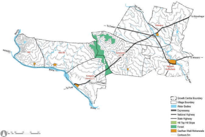
Shikrapur GC is located over the larger basin of River Bhima, where Bhima River forms the southern edge of the Growth centre. Vel River, a tributary of Bhima, passes through the Growth Centre. The area is located comparatively on flat terrain, with its terrain gradually sloping towards the south. Chas Kaman’s left bank canal also passes through the GC. The Forest area running in the north-south direction, located south of Sanaswadi, divides the Growth Centre area into two.
Figure 30.1: Location and Physiography
Chapter 30: Growth Centre: Shikrapu
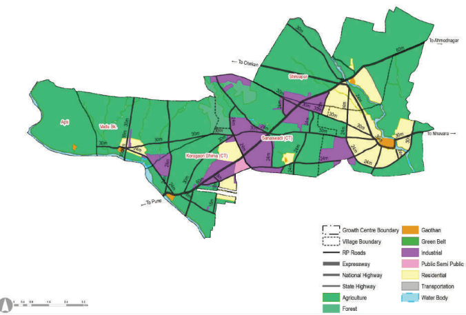
Shikrapur Growth Centre is a part of RP Sectors L. RP 1997 proposed a self-sufficient township for an estimated population of 145,000 by 2011 for the entire Sector, for which the majority of the proposed residential zone (1,038.22 ha) was assigned in Talegaon Dhamdhere, Koregaon Bhima and Sanaswadi. Industrial zone was proposed over 924 hectares at Sanaswadi, Koregaon Bhima, Talegaon Dhamdhere and Shikrapur. The Government forest land and hilly barren land in Sanaswadi, admeasuring about 232.66 ha, are shown in the Forest zone. Since commercial use was generally allowed within residential zoning, sporadic commercial developments are observed along major roads. The total area designated under the agriculture zone was 6,209 Ha.
In terms of the implementation of RP1997, the residential zone is not fully developed as planned. New residential pockets can be seen around Shikrapur. Industrial zones are located on either side of the Pune-Ahmednagar Highway around existing industrial units located in Koregaon Bhima, Sanaswadi and Shikrapur. Residential zoning proposed around Vel River have led to encroachment within flood lines, which need to be addressed by meticulous planning and development control regulations.
Figure 30.2: RP 1997 Zoning Map
Table 30.1RP 1997 Area Statement
Land use category
Area (ha)
Proportion of Total Developed Area(%)
Proportion of Total Area (%)
Residential
1038.22
44.93
11.42
Commercial
0
0.00
0.00
Industrial
924.12
39.99
10.16
Public and semi public
31.71
1.37
0.35
Public Utility
0.00
0.00
Transportation
316.62
13.70
3.48
Defense
0.00
0.00
Total Developed Area
2310.67
Agriculture
6211.59
91.56
68.29
Water bodies
249.68
2.75
2.75
Green Belt
90.27
1.33
0.99
Hill Top Hill Slope
0.00
0.00
Forest
232.66
3.43
2.56
Total Undeveloped Area
6781.92
100.00
Total Area
9094.87
Existing Land Use
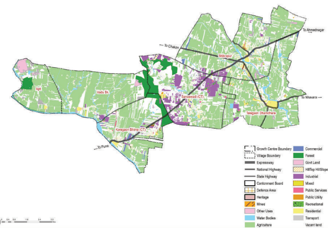
Agriculture use followed by industrial use dominates the existing land use in the Growth Centre. Sanaswadi is a major industrial cluster, whereas residential developments are concentrated in Talegaon Dhamdhere and Shikrapur. Scattered settlements are present around Koregaon Bhima and Sanaswadi.
Natural features constitute about 8% of the land, with a major portion occupied by forest and water bodies. Vacant land use is observed at Sanaswadi, where the majority of the industrial activity is prevalent. Residential land use merely covers about 2% of the total area, and supporting land uses such as commercial, PSPs, and utilities collectively measure about 3%.
Most public facilities such as schools, government offices and health facilities are concentrated in Koregaon Bhima and Shikrapur. KEM Hospital and Al Ameen College of Engineering and Management are notable landmarks in the Growth Centre, along with famous industries such as John Deer, Oriental Rubber and Arcelor.
Figure 30.3: Existing Land Use Map
Chapter 30: Growth Centre: Shikrapu
Table 30.2Existing Land Use Area Statement
Land use category
Area (ha) Poproepdo Artrieoa
n of Total Devel- Proporti (%) Area (%)
on of Total
Residential
194
16.78
2.14
Commercial
72.3
6.26
0.80
Industrial
403.24
34.89
4.45
Public and semi public
175.19
15.16
1.93
Garden, Playground and Recreation
33.44
2.89
0.37
Public Utility
20.72
1.79
0.23
Transportation
256.95
22.23
2.84
Defense
0
0.00
0.00
Total Developed Area
1155.84
Agriculture
4862.42
53.30
Water bodies
320.9
3.54
Vacant Land
2410.2
26.61
Forest
329.5
3.64
Hill Top Hill Slope
13.98
0.15
Total Undeveloped Area
7937
Total Area
9058.42
Traffic congestions along the NH-753 F with no bypass developed
The critical junction at Shikrapur gaothan
High-density development, especially at Shikrapur, with a lack of infrastructure provision
Narrow and unpaved roads leading to poor accessibility
Lack of amenities such as healthcare and social centres
Lack of recreational areas such as playgrounds and gardens
Absence of sewerage, stormwater drainage and solid waste management sites
30.3Proposed Role and Strategies
Shikrapur Growth centre is envisioned as ‘Logistics and Industrial Hub’ based on:
strategic location along the Aurangabad-Ranjangaon-Chakan-JNPT industrial belt
existing access by Pune-Ahmednagar and Chakan-Shikrapur-Nhavare-Daund Highways
surge in logistics demand due to the above credentials
established industrial cluster and proposed industrial zone as per RP 1997
direct accessibility from proposed regional infrastructure projects such as Crescent railway (cargo)
Leveraging upon the above, the proposed Logistics Hub would house a consolidated warehousing and logistics park at Vadhu Bk along the proposed Crescent railway line. Further, the expansion of the industrial cluster at the north of Sanaswadi is proposed to host ancillary industry for automobile, engineering and electronics.
Table 30.3Population Projections
Villages
2011
2018
2031
2041
Apti
1,378
1616
1,862
2,015
Koregaon Bhima (CT)
13,116
17268
21,247
23,187
Sanaswadi (CT)
13,543
18355
26,056
42,859
Shikrapur
19,374
32103
59,989
75,299
Talegaon Dhamdhere
15,393
21348
24,590
25,477
Wadhu Bk.
5,700
7235
8,519
9,181
Total
68,504
97,924
142,263
178,018
The projected resident workforce based on the projected population through the URGD method is 52,032. Considering the proposed economic activities of all the growth centres, employment distribution was proposed based on the envisaged sectoral split for that Growth Centres. Accordingly, the employment to be generated for the Growth Centre for the year 2041 is estimated to be 38957. The proposed residential density is about 125 PPH (12,500 persons/sq km).
For the planning of public facilities distribution, the Growth Center is divided into three sectors: Shikrapur village forms the first sector while Talegaon Dhamdhere and Sansawadi make the second sector. Koregaon Bhima, Vadhu Bk and Apti is the last sector abutting Wagholi Growth Centre.
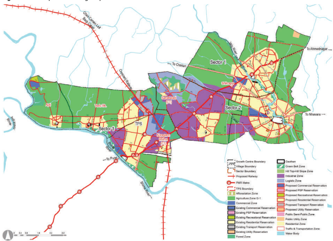
The boundaries of this planning division are shown on the Proposed Zoning Map. The projected sector-wise population statement is in Table 33.4.
Table 30.4Projected Population - Sectors
Sector
2011
2018
2031
2041
Sector 1
19,374
32103
59,989
75,299
Sector 2
28,936
39702
50,646
68,336
Sector 3
20194
26118
31628
34384
Total
68504
97923
142263
178018
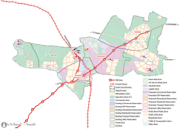
The proposed zoning would guide and determine the optimal and efficient land use for the next 20 years. The proposed zoning plan is an output of existing land use and physical conditions analysis, understanding of most pressing issues of the Growth Center, local knowledge of the place and deployment of five planning goals and allied physical planning strategies. The proposed zoning area statement is presented in Table 30.5.
Chapter 30: Growth Centre: Shikrapu
Figure 30.4: Proposed Zoning Map
Table 30.5Proposed Zoning Area Statement
Land use category
Area (ha)
Proportion of Total De-veloped Area (%)
Proportion of Total Area(%)
Residential
1963.46
44.89
21.59
Gaothan
57.11
1.31
0.63
Commercial
211.96
4.85
2.33
Industrial
1092.56
24.98
12.01
Logistics
397.35
9.08
4.37
Public and semi public
33.3
0.76
0.37
Public Utility
28.42
0.65
0.31
Traffic & Transportation
589.93
13.49
6.49
Total Developed Area
4374.09
Agriculture (G1)
3808.58
41.90
Water bodies
321.6
3.53
Green Belt
134.8
1.48
Forest
371.6
4.09
Recreational
47.51
0.52
Afforestation
35.31
0.39
Total Non-Developable Area
4720.72
Total
9094.87
Proposed zoning ensures that the sectoral development goals are clearly conveyed through it. Proposed sectoral goals and their corresponding physical planning strategies are mentioned in Table 33.5.
Table 30.6Goals and Physical Planning Strategies
Goals
Development Sector Addressed
Physical Planning Strategies
Prudent
Employment and housing
Work- Live Hubs
Convenient
Roads and mass transport
Movement Lattice
Resilient
Environment protection
Green- Blue connectors
Efficient
Infrastructure and utilities
Decentralized resource management
Self- sufficient
Social facilities
Walkable Neighbourhoods
For Shikrapur Growth Center, the Work-Live concept is applied by:
Expected to attract majority of workforce from neighbouring Growth Centres since it is positioned as a major work hub
Designating residential zones within 500 m around industrial, logistic, town centre, and commercial zones to minimize work trips for at least 30% of the resident workforce
Expansion of the existing industrial zone at Sanaswadi and Koregaon Bhima along the NH-753F, which hosts the Metro line (Ramwadi-Wagholi-Shikrapur) to reduce travel time for the workforce to commute within the Growth Centre as well as to and fro other Growth Centers
Proposing a town centre integrated with Multimodal hub adjoining Metro depot, serving the newly proposed Town Planning Scheme at Vadu Bk
Out of the total proposed industrial zone over 186.6 sq km, industrial use over 9.3 sq km is envisaged in Shikrapur Growth Centre, both based on projected employment and 50 workers/ha density.
ELU database indicates that industrial use is prevailing over 403 hectares, whereas RP 1997 proposed industrial use over 924.14 hectares in the GC. Thus considering the existing industrial development scenario, strategic infrastructure proposals and planning intent of the Regional Plan, industrial use is proposed over 1092.56 ha for general industrial activities.
The Development Plan intends to expand the Sanaswadi industrial cluster towards the northern side, optimise the industrial zone area proposed under RP 1997 and synergise with the logistics zone proposed in this Development Plan. The industrial use at Sanaswadi, Koregaon Bhima and near Talegaon Dhamdhere, as proposed in RP 1997, is maintained. The industrial areas would be directly accessed by the proposed Metro line running along the Pune-Ahmednagar highway.
The total logistic land use requirement of the Study Area is estimated to be 20.2 sq km considering projected demographics and area requirement of 55 sqm built-up area per person. 4 sq km of this estimated area is anticipated in Shikrapur Growth Centre. However, considering the proposed role of the GC, the prevailing trend of warehousing and supplementary industries and the proposed strategic infrastructure projects, logistic use is proposed over 397.35 ha.
Chapter 30: Growth Centre: Shikrapu
The intent is to develop consolidated logistics parks at strategic locations to avoid negative impact on surroundings and improve efficiency and economies of scale for logistics operations. In light of this, the logistic zone is proposed along the Crescent railway line at Vadhu Bk. It is also connected to rural catchments utilizing MDR and village roads to support the agriculture sector. Areas with logistics use would be directly accessed by the proposed Metro line and proposed Crescent railway line.
Land requirement for the residential zone is estimated based on a net residential density of 125 PPH. Further, 45% add-on is considered to account for amenity (15%), open spaces (10%) and roads (20%). Accordingly, the total gross area required for the projected GC population of 1,78,019 by 2041 is estimated to be 19.9 sq km.
Considering the projected population, net residential density, proposed role and existing growth trends within the Growth Centre, 1963.46 ha of gross residential zone is proposed. As per the Work Live hub concept, consolidated residential zoning is proposed in the Growth Centre and a bottom-up approach is adopted to allocate residential zones across the Growth Centre. Existing mature settlements at Shikrapur, Talegaon Dhamdhere, Koregaon Bhima, and Sanaswadi are considered social nuclei, and residential zones are allocated around them to drive their future growth. About 202 ha is proposed around Sanaswadi, while 1219 ha is proposed around Talegaon Dhamdhere and Shikrapur. A new residential node is introduced at Vadu BK to cater to the residential demand expected from proposed logistics. Due to the extension of the Vanaz-Ramwadi Metro line to Shikrapur village, most residents would enjoy access to the proposed Metro corridors. The rest of the residential zones would be served using the feeder bus system from the Shikrapur Metro station and the existing state transport system. EWS housing is proposed at Wadhu Bk, Sanaswadi and Talegaon Dhamdhere to facilitate affordable housing projects.
Land requirement for the commercial zone is estimated based on URDPFI guidelines, i.e. 0.6 ha per 1,000 population. Add on of 30% is considered to account for roads (15%), open spaces (10%) and amenities (5%). Accordingly, the total commercial zone requirement for the Study Area is estimated to be 23.77 sq km. 211.96 ha from this area is proposed in the Growth Centre such that equitable distribution of commercial activities is facilitated.
Five commercial nodes are proposed within the Growth Centre to serve the residential zone (Talegaon Dhamdhere, Koregaon Bhima, Vadhu Bk, Shikrapur), where they serve as Neighbourhood Centres. Town Centre is proposed adjoining the commercial node at Vadhu Bk.
The movement lattice concept also includes a mass transit corridor running through the Growth Center centre, high-speed rail crossing the Centre and Ring Road to encourage >50% of the residents to use mass transport for their daily commute.
A parallel system (two 30 m bypasses) to NH-753F is proposed at Koregaon Bhima as suggested in RP 1997, avoiding the congestion on the NH due to logistic activities in Sanaswadi.
A 60 m bypass to NH-548D is proposed at Shikrapur and Talegaon Dhamdhere, avoiding the congestion caused due to gaothan expansion.
Important connection from Vadhu Bk to Talegaon Dhamdhere is proposed as a feeder system of mass transport connecting the Logistic Hub to the prime residential hub.
Development of a 60 m bypass road is proposed for Pune- Ahmednagar Highway at Perane to Koregaon Bhima as suggested in RP 1997.
A grid-iron pattern of collector roads (15-24 m wide) is proposed in Vadhu Bk and Koregaon Bhima, while a radial pattern is proposed at Talegaon Dhamdhere based on existing alignments.
Collector roads (15-24 m wide) follow spacing of 300-500 m. Secondary arterials (30-45 m wide) follow a 1 to 2 km grid pattern, covering all residential areas.
Metro line Ramwadi-Wagholi-Shikrapur is proposed to end at Shikrapur with a spur ending at Vadu Bk at the Metro Hub, integrating it with the Multimodal hub and Town Centre.
The Crescent Railway, proposed as a logistic corridor, has a station proposed at Vadu Bk.
Secondary arterials have the flexibility to run a dedicated bus service for faster transport and support the feeder system and last-mile connectivity.
All proposed roads would be designated with at least 3 m wide footpaths on either side of the road, as the ‘pedestrian right of way’ and ‘hawker-free zone.’
Figure 30.5: Proposed Transport Network Map
Table 30.7Proposed Transport Network Statement
Road Category
Road names/ROWs
Proposed ROWs
Authority
Total Length (km)
Cost of Road Development (Cr.)
Primary
NH548D
60
NHAI
9.72
NH753F
60
NHAI
11.35
Secondary
SH117
45
PWD
2.82
Tertiary
MDR19
24
PWD
7.44
MDR23
24
PWD
2.4
MDR38
24
PWD
1.43
MDR51
24
PWD
2.27
ODR144
18
ZP
17.89
ODR143
18
ZP
3.18
ODR158
18
ZP
8.68
ODR154
18
ZP
1.52
Local
VR (Total)
15
ZP
17.33
Chapter 30: Growth Centre: Shikrapu
DP Roads
Primary
MSRDC Ring Road
110
MSRDC
0
0
Expressway
90
MSRTC
0
0
PMRDA Ring Road
65
PMRDA
0
0
Secondary
45
PMRDA
0
0
30
PMRDA
21.07
2185.43
Tertiary
24
PMRDA
13.06
543.19
18
PMRDA
15.66
1017.19
15
PMRDA
36.62
2202.75
Local
12
PMRDA
14.838
1155.35
9
PMRDA
0.89
690.48
Total Road Length
The existing forest areas between Sanaswadi and Koregaon Bhima are designated as protected areas.
Green Belt zoning is proposed between the river bank and the corresponding blue line for Velu and Bhima Rivers.
All existing streams to be protected.
Water reservoirs within the quarry area need to be protected.
These protected Green-Blue features are recommended to be connected by a 30-45 m wide secondary arterial road that would be upgraded as a tree-lined avenue by developing NMT corridors (>3 m each) on both sides of the road and segregated from footpaths.
Green lungs are proposed within 500 m walkable distance covering an area of 180.67 ha. These green lungs include active and passive recreational spaces. The total active recreational space works out to be 18.35 ha that include playgrounds, sport complex, stadium and multi-purpose ground. And the total passive recreational space works out to be 162.32 ha that include gardens, town park/ regional park, bio diversity park and green belt.
This concept is applied as follow:
Water treatment plant (0.56 ha) is proposed in the west of Sanaswadi, abutting the forest area.
Two STPs (2 ha) are proposed for the Growth Centre and are located at (Shikrapur and Koregaon Bhima) away from residential developments.
A solid waste site is proposed in the east of Shikrapur GC within a rural area serving a 5-8km radius.
The existing electric substation is maintained at Shikrapur.
Renewable energy sites could be proposed and are recommended on higher elevations. However, they would be finalised after a detailed study.
Currently five cremation grounds are present in the Growth Centre, thus no new additional cremation grounds are proposed.
As per existing landuse, there was one burial ground present, hence extension to existing burial ground is proposed.
Fire station is proposed along highway at Shikrapur village
Table 30.8Proposed Infrastructure Demand
Infrastructure System
Demand (2041)
Unit
Utility Sites
Total Area (ha)
Water Supply
3.66
MMC
1 WTP
0.56 ha
Sewerage
2.93
MMC
2 STPs
1.9 ha
Solid Waste
233
Tones/day
2 SWM
2.54 ha
This goal is set to increase the liability index of the Growth Centre. To do that, amenities are proposed within 500 m distance, leveraging the concept of Walkable Neighbourhoods. The concept entails providing basic infrastructure and services for education, health, sports, and recreation within the neighbourhood to have easy access to them by foot.
Amenity provision is made for the projected population by 2031 (142,263 ppl)
Neighbourhood level amenities are located within a 500 m radius from residential zones and are connected by collector/local roads to improve their accessibility from other neighbourhoods.
• Shikrapur & Talegaon Dhamdhere are the matured settlements within the GC thus concentration of amenities is observed here.
Education: Existing schools are well serving the GC and thus only two new schools are proposed, one at Wadhu bk. and one at Talegaon Dhamdhere; Wherever possible, expansion to the existing ZP schools are proposed with proper road access to each of the amenities. No new college is proposed within the Growth Centre as Al Amin College, Madhyamik Vidhyalaya exists at Sanaswadi, already serving the locality.
Health: HC provided considering walking radius within Neighbourhood. A well established Rural Hospital at Shikrapur serves GC and the neighbouring rural villages. The NH 753F is lined by many small to medium sized hospitals and two major accident hospitals namely Siddhi Vinayak and Sai Hospital exists near Shikrapur Gaothan along the Highway. Famous KEM hospital is located at Vadhu Bk and thus no new hospital is proposed. Hospital at Shikrapur is proposed as Trauma care centre. Six health centres are proposed, two at Shikrapur and each at Talegaon Dhamdhere, Wadhu Bk.,Koregaon Bhima, Sanaswadi each.
Socio-Cultural: Community halls provided considering walking radius within Neighbourhood; Socio-cultural
Chapter 30: Growth Centre: Shikrapu
centre is provided at Talegaon Dhamdhere over government owned land
Open Space: Playground located near existing schools and are split into 2 with minimum area 0.8 ha to improve spatial distribution wherever required; Garden, provided along/ near water bodies, within green belt or on Government owned plots; Town Park is proposed at Apti, along Bhima River adjacent to the Spiritual Hub, proposed on a theme of ‘Meditation & Zen Garden’ concept. Sports complex is proposed along 30m bypass at Talegaon Dhamdhere over Government Owned land.
Commercial: Shopping Centre/ market is provided at existing commercial node/ near existing settlements/ available amenity spaces; a Town Centre is strategically proposed integrated with Multimodal Hub adjacent to Crescent Railway Station, within the proposed Logistic Hub, prompting transit-oriented development.
Residential: Public housing is provided at Sanaswadi village as per MHADA requirements and another public/ affordable housing is proposed at Talegaon Dhamdhere village serving the adjoining industrial / commercial activities, covered under the PMAY scheme.Also Public Housing is provided at Wadhu bk.
Transport: A major Transit Node is proposed at Wadhu Bk. which includes Multimodal Hub, Metro Deport, Crescent Railway Station, all adjoining each other, integrated with Town Centre. The Metro line (Ramwadi-Wagholi- Shikrapur) is proposed to run along side Crescent railway from the Nagar Highway, to end at the proposed Metro Depot. Bus terminal is proposed at Sanaswadi over Government owned land at central location serving the GC.; Parking are proposed besides amenities that provide for larger crowd congregation. Crescent railway station occupying almost 18 ha of area is proposed
Civic facilities requested by various government authorities: District court is proposed next to the Logistic Hub of Vadhu Bk while post office is proposed at Sanaswadi.
Table 30.9Summary of Land Ownership of Proposed Amenities
Land Ownership
No of Amenity
Total Area (ha)
Government Land
13
69.56
Private Land
40
73.67
Amenity Space
11
3.49
Other
11
15.72
Total
75
162.44
Implementation Strategy for the Proposed Reservations
Town Planning Scheme: PMRDA envisages implementing the Development Plan proposals by enabling the provision of Town Planning Schemes, which will considerably reduce liability towards the direct cost of acquisition of land required for social and physical infrastructure. To achieve the economic role of ‘Industrial & Logistic Hub’, a town planning scheme is proposed at Vadhu Bk with possibility of the Logistic zone to be reserved under authority plot
The reservations proposed to be developed using the TPS mechanism are as follows: a. Strategic Project: Crescent Railway and Station, Multimodal hub and Metro & Metro Depot, Logistic Hub b. Amenities: Town Centre and other neighbourhood level amenities
The other proposals/reservations of the Development Plan are proposed to be acquired and developed through the mechanism of Accommodation of Reservation and Transfer of Development Rights (TDR) policy. It is estimated that all proposed roads and 50% of the public reservations will be acquired through TDR/FSI/ AR.
The remaining reservations will be acquired under the provision of the Land Acquisition Act by paying monetary compensation.