Hinjewadi is positioned as a “Regional Centre and IT Hub” focusing on IT/ITES, Artificial Intelligence and Robotics, leveraging its existing robust technology setup and expanding on the MIDC development in the area. It will fill the gap of a business district in the west of Pune agglomeration and complement the business requirements of the proposed IT hub. With substantial land available for development, it will cater to affordable housing and absorb high demand for commercial development that is likely to be generated by under construction Pune Metro Line 3 (Hinjewadi-Shivajinagar), PMRDA and MSRDC Ring Road and its proximity to Pune-Mumbai Expressway.
Promote IT/ITES along with Financial Services, Fintech and Blockchain activities through the development of the proposed Regional Centre at Hinjewadi.
Increase residential developments along the Regional Centre and MIDC area, promoting the work-live concept.
Cater to expected high demand for commelrcial development on account of the proposed Metro Line 3; complement business requirements of the industrial sector through a business centre.
Promote IT industrial activities by consolidating cluster development leveraging upon existing high demand around the MIDC estate.
Develop a grid network of secondary and tertiary roads for a smooth movement within the Growth Centre
Development of the proposed PMRDA and MSRDC Ring Roads stretch of 17.03 km and 10.76 km, respectively passing longitudinally through the Growth Centre
Widen SH-130 to 45 m RoW as a bypass to the existing MIDC area.
Promote residential development along PMRDA Ring Road (multimodal corridor), state highway, metro corridors, expressway and surrounding MIDC areas
Protect all the natural streams in the Growth Centre.
Establish green-blue links by connecting streams, forest and green belts of three rivers: Pawana, Khaparganga and Mula.
Promote self-sufficient town by proposing required amenities and utilities for the projected population.
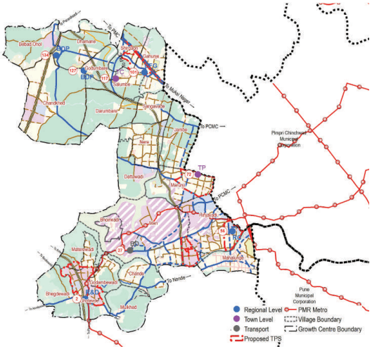
Proposed Metro line extension of Hinjewadi-Shivajinagar route connecting Industrial TPS through SH-130 towards Pirangut Growth Centre
Regional Centre at Hinjewadi.
Research and development centre at Ghotawade
Trauma care centre along the YashwantraoChavan Expressway at village Gahunje
Town Planning Scheme at Hinjewadi (for implementation of Regional Centre)
Industrial Town Planning Scheme at Ghotawade along the MSRDC Ring Road and SH-130
Town Planning Scheme at Shirgaon and Gahunje along the YashwantraoChavan Expressway
Residential Town planning scheme at Marunji.
Bio-Diversity Park on government-owned land shared by Gondambare and Dhamne village.
Exihibition cum fair ground at Gahunje.
26.2Existing Situation Analysis
Hinjewadi Growth Centre falls under two talukas - Mawal and Mulshi, comprising 23 villages. Dhamne, BebadOhol,Chandkhed, Darumbare,Gahunje, Godumbare, Shirgaon, Salumbare, Sangavade villages fall under Mawal taluka. Bhoirwadi, Maan, Mahalunge (N.V.), Chande, Ghotavde, Bhegadewadi, Mulkhed, Godambewadi, Marunji, Dattawadi, Jambe, Materewadi, Nere, Hinjewadi villages fall under Mulshitaluka. The total area of Hinjawadi Growth Centre is 140.63 sq km. According to Census 2011, Hinjewadi Growth Centre population was 62,509.
Hinjewadi Growth Centre enjoys great locational advantage due to its proximity to adjoining PMC and PCMC developments, Hinjewadi MIDC/IT Park and Pune-Bangalore National Highway / Pune-Mumbai Expressway, two of the busiest transport routes in PMR. RP 1997 recognized Hinjewadi as an industrial centre with supporting residential development.
Hinjewadi Growth Centre lies in the western part of the Pune Metropolitan Region. It is surrounded by Talegaon Growth Centre and Maval taluka on the northern side, Mulshi taluka on the Western side and adjoining Pune Municipal and Pimpri Chinchwad Municipal Corporation boundary on the eastern side.
Mumbai-Pune-Bangalore Highway (NH-48) improves the connectivity of the Growth Centre with surrounding urban and rural areas. SH-130 running through the Growth Centre is the central spine between many villages as well as MIDC areas in the Growth Centre. Both MSRDC and PMRDA Ring Roads are prominent connectivity links with the entire Pune Metropolitan Region. It is convenient to reach Hinjawadi GC from Pune International Airport and the proposed airport at Navi Mumbai via Pune-Mumbai Expressway.
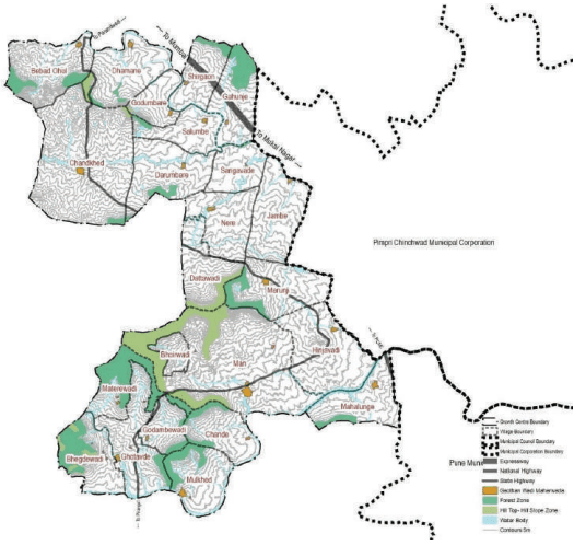
Hinjewadi Growth Centre is situated on the foothills of the Western Ghats. Most of the Growth Centre has flat terrain with subtler slopes towards the Mula River. The western hilly range in villages Mulkhed, Ghotawade, Chande, Godambewadi, Materewadi, Bhoirwadi, Man and Marunji is covered with dense vegetation under a forest area of 1093.41ha. Growth Centre lies between Pawana River in the north and Mula River in the south along with the Khaparganga River that is tributary of the Mula River itself.
Chapter 26: Growth Centre: Hinjewadi
Figure 26.1: Location and Physiography
Regional Plan 1997 Analysis
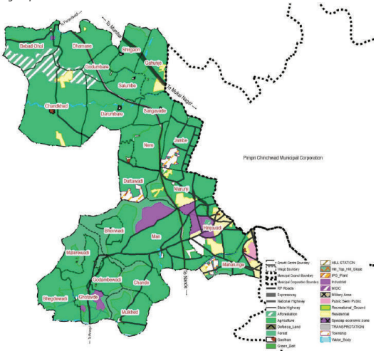
Hinjewadi Growth centre includes part of RP Sectors such as Sector PMR, Maval zone plan, B, C, and NOR. The industrial zone within Sector B was proposed for sugar factory-like development. It was also suggested to consider a new civil airport on the north of Hinjewadi between the existing westerly diversion and proposed expressway. On the other hand, sector C was envisioned to have more of residential development, considering its faster development into a residential suburb. The major industrial zone was proposed in Mann, Ghotawade and Hinjewadi villages which is majorly realised. Thus majorly IT industrial trend is observed in this Growth Centre.
The major residential zone is proposed in villages Gahunje, Marunji, Hinjawadi, Mahalunge and Chandkhed which is majorly realised. The residential zone proposed at Hinjawadi and Gahunje is observed to be accomplished, whereas the residential zone proposed at Marunji could not be implemented as it was cordoned off due to surrounding forest and industrial development. Some organised residential development is observed in the Agriculture zone surrounding 500 m of the Goathan extension.
Agriculture zone over an area of about 10418 ha dominates the Growth Centre Land Use. Weak enforcement of RP development regulations can be seen in unauthorised developments on agricultural zones near Marunji, Jambe and Gahunje adjoining existing industrial land-use and transport corridors.
Government Forest, private pad, slopes and hilly areas were proposed in the afforestation zone. Mula River, Pawana River and Kaparganga River with greenbelt and few Nalas are marked on RP 1997.
Transport network included:
PMRDA Ring Road
SH-130 with 36 m RoW
Major road grid of 36 m RoW proposed at Man and Hinjawadi
30 m regional road in Jambe, Marunji, Hinjawadi and Mulkhed villages
Figure 26.2: RP 1997 Zoning Map
Table 26.1Regional Plan Area Statement
Land use category
Area (ha)
Proportion of Total Developed Area (%)
Proportion of Total Area (%)
Residential
663.30
37%
5%
Gaothan
77.56
4%
1%
Industrial
446.42
25%
3%
Public and semi public
60.72
3%
0%
Special Economic Zone
84.79
5%
1%
Transportation
482.28
27%
3%
Total Developed Area
1815.08
100%
13%
Agriculture
10418.84
74%
Afforestation
579.90
4%
Water bodies
255.08
2%
Green Belt Zone
3.18
0%
Forest
991.26
7%
Total Undeveloped Area
12248.25
87%
Total Area
14063.33
100%
Chapter 26: Growth Centre: Hinjewadi
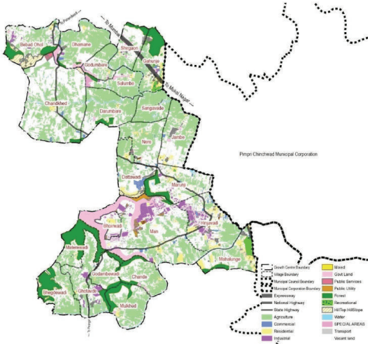
The most dominant land uses in Hinjawadi Growth Centre are Agriculture and Industrial. Industrial developments can be seen in over 2.45% of the total Growth Centre area, whereas Agricultural activities are taking place over 36.99% of the total Growth Centre area.
The major part of industrial development at Hinjawadi and Man villages fall under MIDC estate, dominated by IT activities. Industrial activity at Marunji and Hinjawadi complement the industrial activities within MIDC areas. Warehousing related activities can be seen alongside State Highway 130. MIDC Estate includes IT companies such as TCS, Wipro, Cognizant, Mahindra Tech, HCL, Dassault, KPIT, Persistent, Accenture, Capgemini, TCS, Synechron, Hexaware. SME cluster is present adjoining it, supporting engineering, paints, tools and components, consumer goods and machine parts. Hinjawadi Biotech Park includes core biotech (Emcure pharmaceuticals, Genova, Centaur, TCG, Avian Life Sciences) and ITES (Barclays, HDFC).
Residential development took place supporting the IT development and thus integrated townships such as Life Republic ITP, Xrbia Township, Blue Ridge and Riverview Township and the approved town planning scheme at Mahalunge Man have developed in the Growth Centre.
Existing public facilities such as Gahunje Stadium, Shri Chatrapati Shivaji Krida Sankul, Symbiosis International University, Alard institute, etc., are present in this Growth Centre.
Figure 26.3: Existing Land Use Map
Table 26.2Existing Land Use Area Statement
Land use category
Area (ha)
Proportion of Total Developed Area (%)
Proportion of Total Area (%)
Residential
492.43
22.18%
3.50%
Commercial
138.83
6.25%
0.99%
Industrial
345.14
15.55%
2.45%
Mixed
8.36
0.38%
0.06%
Public and semi public
701.85
31.62%
4.99%
Garden, Playground and Recreation
85.59
3.86%
0.61%
Public Utility
62.93
2.83%
0.45%
Transportation
360.09
16.22%
2.56%
Special Area
24.71
1.11%
0.18%
Total Developed Area
2,219.93
100.00%
15.79%
Agriculture
5202.46
36.99%
Water bodies
362.34
2.58%
Vacant Land
4960.29
35.27%
Hilltop hill slope
227.73
1.62%
Forest
1090.69
7.76%
Total Undeveloped Area
11843.51
84.21%
Total Area
14,063.43
100.00%
Key Challenges
Compared to the existing demand and surge in the growth of industries, transport infrastructure is not adequate. It has led to traffic congestion issues majorly along SH-130 due to encroachment and non-development of bypass/alternative route.
Existing residential development is not in line with the proposed Residential Zones in Regional Plan 1997. Instead, sporadic residential development along major transport corridors and near the Gaothan area is observed.
Significant unplanned development in agriculture zones such as unauthorized residential and industrial development is observed surrounding Gaothans in the agriculture zone.
Scarcity of water and the absence of an adequate sewage system are observed.
26.4Proposed Reservation Statement, Costing and Phasing
Table 26.10Proposed Reservation Statement
Sr.
Purpose of Reservation
Planning Standard
Required as per Norms
Existing
Proposed amenities considering Walkable distance
Total
Area
Min unit required
No of sites
Area in Ha
No of sites
Area in Ha
No of Sites
Area in Ha
No of sites
Area in Ha
1
2
3
4
5
6
7
8
9
10
11
12
1
Primary School I - V
0.4 ha including playground.
1/500 students
35
14
41
14
8
4
49
18.05
1/5000 population
2
Secondary VI - XII
1 Ha. / site (0.6 ha for play ground and 0.4 ha for building)
1/1000 students
17
17
39
47
5
3.11
43
51.01
1/7500 population
3
Healthcare Centre
1HC / 15,000 population
12
1.2
0
0
13
3.51
23
5.77
0.08 - 0.12 Ha
4
Community Hall
1 /15,000 population
12
2.4
0
0
11
2.7
11
2.7
0.2 ha/ site
5
Garden
1/15000 population
12
12
0
0
21
15.11
21
15.11
1 Ha
6
Playground
1.5Ha
1/15,000 population
12
18
0
0
26
23.15
26
23.15
7
Shopping Centre
0.3- 0.45 Ha
1/15,000 population
12
5.4
0
0
12
8.06
12
8.06
Parking
1
0.71
1
0.71
8
Hospital/Trauma Care Centre
Cat A = Area- 3.70 Ha
1/100,000 population
2
2
0
0
6
7.23
6
7.23
200 beds, Cat B = Area =1 Ha., 80 beds
9
Cultural Centre/Social Welfare Centre/Socio-Cultural Centre
Area- 0.6 - 1Ha
1/1 lakh
4
3.2
0
0
4
4.5
4
4.5
10
Town Park
Area = 3- 5 Ha.
1 / 1 lakh
2
10
0
0
1
1.45
1
1.45
11
Sport Centre
Area = 3- 5 Ha.
1 / 1 lakh
2
6-10
2
6.9
1
3.39
3
10.29
12
Fire Brigade station
0.4 Ha.
As per requirement of Fire department of PMRDA. 1 Fire station / growth centre
1
0.4
0
0
0
0
0
0
13
Burial ground
4 Ha.
1 site/ 5 lakh,
1
1.39
1
0.29
1
0.89
2
1.18
14
Cremation ground
2.5 Ha
1 site/ 5 lakh,
1
0.87
22
1.96
22
1.96
15
Solid Waste Management Site
5 Ha . (As per land availability)
1 site per growth centre
3
4.73
3
4.73
Chapter 26: Growth Centre: Hinjewadi
Sr.
Purpose of Reservation
Planning Standard
Planning Standard
Required as per Norms
Required as per Norms
Existing
Existing
Proposed amenities considering Walkable distance
Proposed amenities considering Walkable distance
Total
Total
Sr.
Purpose of Reservation
Area
Min unit re-quired
No of sites
Area in Ha
No of sites
Area in Ha
No of Sites
Area in Ha
No of sites
Area in Ha
16
Sewerage treatment plant
80% of water supply may be expected to reach the sewers
Land area requirement is as per URDPFI i.e. For activated Sludge Process (ASP)-0.15 Ha/ MLD
4
4.97
4
4.97
17
Water works (Water treatment Plant, tanks & pipes)
Land area requirement is as per URDPFI i.e. 1) 5MLD- 0.10 Ha 2) 10MLD-0.19Ha 3) 50MLD- 0.93 Ha 4) 100MLD-1.87Ha 5) 200MLD-3.73Ha 6) 500MLD-9.34Ha
Water require-ment of PMR is 72 lpcd as per Report 'Integrat-ed Master Plan Of Water Supply, Sewerage, Storm Water and Solid Waste Management in the PMR'. It is distributed to each Growth center.
2
5.19
2
5.19
18
Town Centre
2.5 ha (As per concept plan)
-
1
5.13
1
5.13
19
Public Housing
11
39.19
11
39.19
20
Housing for Dishouse
1
0.79
1
0.79
21
Multipurpose Ground
1
1.6
1
1.6
22
Government Purpose
1
1.59
1
1.59
23
Government Office
1
1.13
1
1.13
24
Research and Development Centre
1
6.9
1
6.9
25
Spiritual Centre
Area - 15 Ha
Table 26.11Cost and Acquisition Statement for Proposed Reservations
Res-erva-tion No.
Purpose of Reservation
Taluka
Village Name
S. No/ Gut No./ CTSNo./F.P.No
Area (ha)
Land Own-ership(Govt/GP/PMRDA/Private)
Total Cost of Acqui-sition (INR Cr)
Total Cost of Devel-opment (Const.) (INR Cr)
Total Cost (INR Cr.)
Appro-priate Author-ity
1
Public Housing
Mulshi
Mulkhed
198
5.63
Gairan
0.00
158.88
158.88
PMRDA
2
Research and Develop-ment Centre
Mulshi
Ghotavde
173, 174,175, 176,177, 178,179, 181,183, 184,186
6.95
Private
0.00
130.91
130.91
PMRDA
3
Public Housing
Mulshi
Bhegdewadi
318
2.44
Gairan
0.00
68.75
68.75
PMRDA
4
Community Hall
Mulshi
Ghotavde
380
0.17
Sarkari Akaripad
0.00
4.35
4.35
PMRDA
5
Shopping Centre
Mulshi
Ghotavde
382
1.01
Gairan
0.00
26.30
26.30
PMRDA
6
Health Centre
Mulshi
Ghotavade
352
0.47
Amenity Space
0.00
11.81
11.81
PMRDA
7
Playground
Mulshi
Godambe-wadi
658
1.48
Private
0.81
2.98
3.79
PMRDA
8
Shopping Centre
Mulshi
Godambe-wadi
247, 250
0.33
Private
0.18
8.65
8.83
PMRDA
9
Garden
Mulshi
Godambe-wadi
228, 229
0.44
Private
0.24
1.27
1.50
PMRDA
Chapter 26: Growth Centre: Hinjewadi
Res-erva-tion No.
Purpose of Reservation
Taluka
Village Name
S. No/ Gut No./ CTSNo./F.P.No
Area (ha)
Land Own-ership(Govt/GP/PMRDA/Private)
Total Cost of Acqui-sition (INR Cr)
Total Cost of Devel-opment (Const.) (INR Cr)
Total Cost (INR Cr.)
Appro-priate Author-ity
10
Playground
Mulshi
Godambe-wadi
179, 180
0.80
Private
0.44
1.62
2.06
PMRDA
11
Garden
Mulshi
Chande
276, 278,279
0.50
Private
0.27
1.46
1.73
PMRDA
12
Community Hall
Mulshi
Chande
268, 269
0.21
Private
0.12
5.53
5.64
PMRDA
13
Playground
Mulshi
Chande
210
1.56
Private
0.86
3.16
4.01
PMRDA
14
Primary School+Sec-ondary School
Mulshi
Chande
210
0.81
Private
0.45
15.35
15.80
PMRDA
15
Shopping Centre
Mulshi
Chande
300
0.46
Private
0.25
12.07
12.32
PMRDA
16
Public Housing
Mulshi
Chande
215
0.82
Private
0.45
23.15
23.60
PMRDA
17
Burial Ground
Mulshi
Chande
150P
0.89
Gairan
0.00
3.69
3.69
PMRDA
18
Water Traetment Plant
Mulshi
Chande
150
2.52
Gairan
0.00
47.59
47.59
PMRDA/Govern-ment
19
Electric Sub-station
Mulshi
Chande
89
2.86
Gairan
0.00
0.00
0.00
Maha-rashtra State Electric-ity <sub>Trans</sub>-mission Compa-ny Ltd, Pune.
Water Works (Water Treatment Plant, Tanks and Pipes)
18, 129
20
Government Purpose
23
21
Government Office
53
22
Carshed and Public Commercial Use
28
23
Regional Centre
56
24
PMRDA Authority Plot
29
25
Biodiversity Park
134
127
26
Research and Development Centre
2
27
Exihibition cum Fair Ground
101
28
Electric Sub-station
19
29
Intracity Bus Depot
27
31
Public Housing
1, 31, 48, 78, 113,121
3, 79
126
16
32
Metro Amenity
60, 64, 65
Total Cost of development of Reservations of UGC : Hinjawadi
Total Acquisition cost of Reserva-tions ( in Rs.CR.)
Total Con-struction cost of Reser-vations ( in Rs.CR.)
Total Cost of development of Reservations( in Rs.CR.)
Road con-struc-tion cost
Total Devel-opment Cost
Reservation on Amenity Space/TP scheme/Government (A)
0.00
2567.46
2567.46
2453.00
5432.99
Reservations on Private land
217.52
607.54
825.06
50% of the total cost of reservations on private land with an assumption that 50% of reservations will be developed through TDR/AR & In-situ FSI (B)
108.76
303.77
412.53
Total Cost (A+B)
108.76
2871.23
2979.99
26.3Proposed Role and Strategies
Hinjewadi is positioned as a “Regional Centre and IT Hub,” and the key reasons for this are as follow:
Capacity for natural expansion for the IT sector along with financial services, fintech and AI.
Proximity to the ‘High Tech City’ of Mahalunge-Man Town Planning Scheme.
Fill the gap of a business district in the west of Pune agglomeration and complement the business requirements of the proposed IT hub.
Leverage the existing robust technology setup in the area and expanding on nearby MIDC development.
Potential integrate Regional Centre with major transport corridor.
With substantial land available for development, the potential of the area to cater to affordable housing and absorb high demand for commercial development that is likely to be generated by under construction Pune Metro Line 3 (Hinjawadi-Shivajinagar), PMRDA and MSRDC Ring Road and its proximity to Pune-Mumbai Expressway.
Potential for development of Town Planning Schemes.
Chapter 26: Growth Centre: Hinjewadi
Considering the above, transit-oriented linear development is proposed along the PMRDA Ring Road and Pune Metro Line 3. Hinjawadi Growth Centre is envisioned to become one of the high density residential Growth Centre. It is expected to host major services industries in PMR, leveraging its role as Regional Centre and Western IT Hub, focusing on IT/ITES, offices and retail, financial services, fintech, AI, and robotics.
Based on the URGD method, the projected population for the Growth Center is presented in Table 22.3.
Table 26.3Population Projections
Village
2011
2018
2031
2041
Bebad Ohol
2,928
3,510
4,198
4,650
Bhegadewadi
1,330
1,602
1,927
2,141
Bhoirwadi
700
2,698
4,014
4,579
Chande
1,273
1,723
2,133
2,354
Dattwadi
1,420
1,951
17,876
33,559
Dhamane
975
1,068
1,129
1,166
Gahunje
4,046
15,509
22,734
25,430
Ghotavde
2,280
3,107
3,399
3,385
Godambewadi
987
1,325
2,260
3,279
Godumbare
1,069
1,126
1,117
1,107
Hinjavadi (CT)
11,459
23,501
44,239
61,799
Jambe
1,895
2,324
18,944
35,403
Mahalunge (N.V.)
6,471
13,299
89,675
163,102
Man
7,527
14,840
23,007
29,133
Marunji
4,853
9,478
18,617
27,142
Materewadi
574
615
628
635
Mulkhed
1,159
1,254
1,301
1,328
Nere
1,587
2,488
5,333
7,833
Salumbare
1,397
1,658
1,936
2,113
Sangavade
1,411
1,773
2,025
2,138
Shirgaon
1,565
2,129
2,486
2,619
Chandkhed
3,867
11,917
16,157
16,381
Darumbare
1,736
1,736
2,634
2,963
Total
62,509
1,21,464
2,87,771
4,34,241
The projected resident workforce based on the projected population through the URGD method is 1,94,807 Considering the proposed economic activities of all the growth centres, employment distribution was proposed based on the envisaged sectoral split for that Growth Centres. Accordingly, the employment to be generated for the Growth Centre for the year 2041 is estimated to be 1,95,259. The proposed residential density is about 125 PPH (12,500 persons/sq km).
For the planning of public facilities distribution, Hinjawadi Growth Center is divided into two sectors. Sector 1 is located on the northern side comprising 10 villages: [Bhegadewadi, Bhoirwadi, Chande,Ghotavde, Godambewadi, Hinjavadi (CT), Mahalunge (N.V.), Man, Materewadi, Mulkhed]. The southern sector includes 13 villages: [BebadOhol, Dattwadi, Dhamane, GahunjeGodumbare, Jambe, Marunji, Nere, Salumbare, Sangavade, Shirgaon, Chandkhed, Darumbare].
The boundaries of this planning division are shown on the Proposed Zoning Map. The projected sector-wise population statement is in Table 27.4.
Table 26.4Projected Population - Sectors
Sector
2011
2018
2031
2041
Sector 1
39,363
77,616
1,91,378
2,91,080
Sector 2
23,146
43,012
96,395
1,43,162
Total
62,509
1,21,464
2,87,771
4,34,241
Proposed Zoning
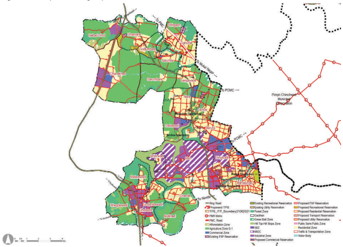
The proposed zoning would guide and determine the optimal and efficient land use for the next 20 years. The proposed zoning plan is an output of existing land use and physical conditions analysis, understanding of most pressing issues of the Growth Center, local knowledge of the place and deployment of five planning goals and allied physical planning strategies. The proposed zoning area statement is presented in Table 22.5.
Figure 26.4: Proposed Zoning Map
Chapter 26: Growth Centre: Hinjewadi
Table 26.5Proposed Zoning Area Statement
Land Use Category
Area (ha)
Proportion of Total Devel-oped Area (%)
Proportion of Total Area(%)
Residential
3300.099
48.25%
23.46%
Gaothan
58.418
0.85%
0.42%
Commercial
382.709
5.60%
2.72%
Industrial
802.175
11.73%
5.70%
SEZ
39.424
0.58%
0.28%
MIDC
1095.422
16.02%
7.79%
Public semi Public
139.675
2.04%
0.99%
Transport
994.279
14.54%
7.07%
Public Utilities
27.226
0.40%
0.19%
Total Developable Area
6839.428
100.00%
48.63%
Agriculture
4598.071
32.69%
Forest
1079.143
7.67%
Hilltop Hillslope
497.883
3.54%
Recreational zone
184.854
1.31%
Green Belt Zone
433.156
3.08%
Afforestation
105.656
0.75%
Water Body
326.211
2.32%
Total Non-Developable Area
7224.974
51.37%
Total
14064.402
100.00%
Proposed zoning ensures that the sectoral development goals are clearly conveyed through it. Proposed sectoral goals and their corresponding physical planning strategies are mentioned in Table 33.5.
Table 26.6Goals and Physical Planning Strategies
Goals
Development Sector Addressed
Physical Planning Strategies
Prudent
Employment and housing
Work- Live Hubs
Convenient
Roads and mass transport
Movement Lattice
Resilient
Environment protection
Green- Blue connectors
Efficient
Infrastructure and utilities
Decentralized resource management
Self- sufficient
Social facilities
Walkable Neighbourhoods
For Hinjawadi Growth Center, the Work-Live concept is applied by:
Proposing Regional Centre in the proximity of Metro corridor and positioning the GC as Western IT Hub with adjoining residential area
Designating residential zones within 500 m around Regional Centre, Business Centre, industrial and commercial zones to minimize work-related trips for at least 30% of the resident workforce
Expansion to the existing industrial zone to a total of 860 ha in GC and commercial zones at Hinjewadi to reduce travel time for commuting within the Growth Centre and to and fro from other Growth Centres
Out of the total proposed industrial zone over 186.6 sq km, industrial use over 18.7 sq km is envisaged in Hinjewadi Growth Centre, both based on projected employment and 50 workers/ha density. Proposed share of IT
ELU database indicates that industrial use is prevailing over 345 hectares, whereas RP 1997 proposed industrial use over 113.40 hectares in the GC. Thus considering the existing industrial development scenario, strategic infrastructure proposals and planning intent of the Regional Plan, industrial use is proposed over 802.17 Ha for general industrial activities. MIDC cover 1138 Ha of area in growth centre. Thus total Industrial development in growth centre is about 1940.17 Ha. The Development Plan intent is to allow expansion of industrial development/ IT development south of MIDC and along transport corridor. Thus Industrial zone proposed along 110m ring road in Chandkhed and Bebadohol. 341 ha of industrial TPS proposed in Ghotavade.
Land requirement for the residential zone is estimated based on a net residential density of 125 PPH. Further, 45% add-on is considered to account for amenity (15%), open spaces (10%) and roads (20%). Accordingly, the total population of ITP & TPS in the Growth Centre is 2,26,090 while the projected population for the rest of the Growth Centre area is 2,08,151. Accordingly, the total gross area required for the total projected GC population of 4,34,241, is estimated to be 30.9 sq km
Considering the projected population, net residential density, proposed role and existing growth trends within the Growth Centre, 3300 Ha of gross residential zone is proposed. As per the Work Live hub concept, consolidated residential zoning is proposed in the Growth Centre. Understanding the current trend of industrial development, 551 ha of residential zone is proposed in Hinjewadi and Maan village. Along with that on the northern side of MIDC, 1207 ha residential use proposed in Marunji, Jambe, Nere and Sangwade which form the major residential node of the Growth Centre. Residential town planning scheme of 117 ha is proposed in Shirgaon and Gahunje Residential TPS of 236.56 ha is also Proposed at Marunji. Also residential zone is proposed for the expansion of four Gaothans, which are located away from main development.
Land requirement for the commercial zone is estimated based on URDPFI guidelines, i.e. 0.6 ha per 1,000 population and topping up 30% (15% road, 10% open space, 5% amenity). Accordingly, the total commercial zone requirement for the Study Area is estimated to be 23.77 sq km. The total commercial zone works out to be 162 Ha; while 382.70 Ha commercial zone is proposed to account for equitable distribution of commercial activities.
Three cardinal commercial nodes are proposed, two serving Hinjewadi Gaothan, sanctioned TPS and MIDC area. Third one proposed in Proposed TPS along MSRDC Ring Road serving Ghotawade Gaothan.
The movement lattice concept also includes a mass transit corridor running through the Growth Center centre, high-speed rail crossing the Centre and Ring Road to encourage >50% of the residents to use mass transport for
Chapter 26: Growth Centre: Hinjewadi
their daily commute.
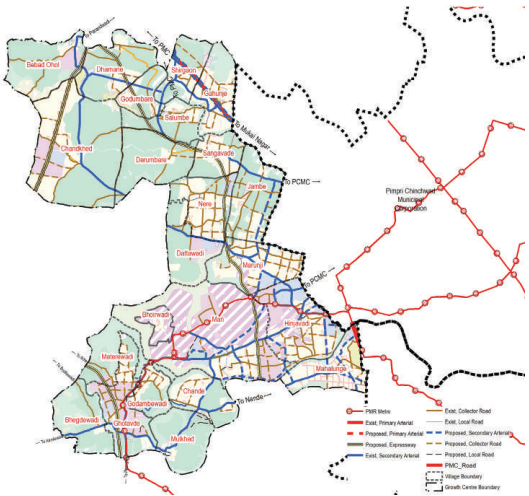
PMRDA Ring Road and SH-130 (major bypass to MIDC and allied industrial zone) are prime spine roads running longitudinal throughout the growth centre, with RoW of 65 m and 45 m respectively.
A parallel road system (30 m RoW) to Ring Road and SH-130 is proposed on the eastern side, bypassing the congested section and disconnecting it from local traffic.
Parallel bypass to Mumbai Bangalore National Highway NH-48 is proposed near Chandni Chowk-PMC boundary) as a secondary link up to PMRDA Ring Road.
Interconnectivity within Mahalunge Mann Town Planning Scheme is provided through the proposed 36 m wide link through MDR-122.
Secondary arterials have the flexibility to run a dedicated bus service for faster transport and support the feeder system and last-mile connectivity.
Grid-iron pattern of collector roads (15-24 m wide) is proposed in the Growth Centre for internal connectivity, covering all the residential and industrial areas.
PWD delineated existing roads are proposed for widening as per the planning requirements of Growth Centre roads.
Figure 26.5: Proposed Transport Network Map
Table 26.7Proposed Transport Network Statement
Road Category
Road names/ ROWs
Proposed RO
Ws Authority
Total Length Cost of Road (km) Development
Primary
NH 48 Yashwantrao Chavan Expressway
60, 1290
NHAI NHAI
0.953.76
Secondary
SH 130
24,45
PWD
25.37
Tertiary
MDR 105
18, 24, 30
PWD
5.1
MDR 109
24
PWD
2.5
MDR 122
24, 36
PWD
12.38
MDR 152
30, 36, 45
ZP
1.99
MDR 157
30
ZP
4.06
MDR 28
24
ZP
3.14
ODR 66
18
ZP
1.9
ODR 73
18, 24
ZP
6.4
ODR 81
18, 24
ZP
6.12
ODR 82
18, 30
ZP
5.7
ODR 83
18
ZP
2.2
Local
VR 104, 110, 115, 131,20, 66, 76, 82, 85, 93,95
15-24
ZP
23.24
DP Roads
Primary
MSRDC Ring Road
110
MSRDC
10.76
PMRDA Ring Road
65
PMRDA
17.08
574.862
Secondary
36
PMRDA
11.98
259.242
30
PMRDA
25.2
367.492
Tertiary
24
PMRDA
25.26
307.909
18
PMRDA
90.95
741.115
15
PMRDA
17.4
128.934
Local
12
PMRDA
10.72
74.058
Total Road Length
314.16
2453.61
Resilient: Green-Blue Connector
The existing forest areas at Bhegdewadi, Materwadi, Chande, Godambewadi, Ghotavade, Mulkhed, Mahalunge, Marunji, Sangavade, Gahunje, Shirgaon, Dhamne and BebadOhol are designated as protected areas.
Green belt Zone to be reserved between the river bank up to the blue line for rivers Mula, Khaparganga and Pawana.
All existing streams to be protected
Green lungs are proposed within 500 m walkable distance covering an area of 542.34 ha. These green lungs include active and passive recreational spaces. The total active recreational space works out to be 35.11 ha that include playgrounds, sport complex, stadium and multi-purpose ground. And the total passive recreational space works out to be 507.22 ha that include gardens, town park/ regional park, bio diversity park and green belt.
Chapter 26: Growth Centre: Hinjewadi
The realisation of the ‘Efficient’ goal would mean successful management of natural resources and implementation of proposed infrastructure network as well as utility sites covering 100% projected population of a Growth Centre. These networks are proposed to be integrated systems using smart metering, renewable energy and SCADA systems. The goal would cover infrastructure systems such as water supply, wastewater, storm water, electricity and solid waste management systems. This goal has been addressed by estimating demand/flow/load for each system, and utility sites are provided either within the Growth Centre or nearby area based on topographic and travel distance considerations.
Two water treatment plants over an area of 5.19 ha are proposed at Chande and Dhamne on government land.
Solid waste management site is proposed in GC. One site is on government-owned land along MDR-105 in Chandkhed village. Another site is at Dhamne, serving areas within 5-8 km radius. Third one in Proposed at Bebadohol
Four sewage treatment plants (1.08 ha, 1.21 ha, 1.04 ha and 1.62ha) are proposed at Marunji, Hinjawadi, Godumbare and Chande considering the topography and gravity system away from residential developments.
EHV substation (2.68 ha) is proposed at Chande village.
Burial ground (0.88 ha) is proposed in Chande village.
Currently, an adequate number of cremation grounds are present in the Growth Centre. Thus no new additional cremation grounds are proposed.
Table 26.8Proposed Infrastructure Demand
Infrastructure System
Demand (2041)
Unit
Area Requirement (Ha)
Utility Sites
Total Area (Ha)
Water Supply
14.25
MLD
0.29
2 WTP
5.19 ha
Sewerage
14.99
MLD
2.12
4 STPs
4.97 ha
Solid Waste
58.99
TPD
As per Land Availability
3 SWM
4.73 ha
Self-sufficient: Walk able Neighbourhoods
This goal is set to increase the livability index of the Growth Centre. To do that, amenities are proposed within 500 m distance, leveraging the concept of Walkable Neighbourhoods. The concept entails providing basic infrastructure and services for education, health, sports, and recreation within the neighbourhood to have easy access to them by foot.
Amenity provision is made for the projected population by 2031 (1,74,726 people)
Neighbourhood level amenities are located within a 500 m radius from residential zones and they are connected by collector/local roads to improve their accessibility from other neighbourhoods.
Education: Primary Schools and Secondary Schools are clubbed together and provided at newly opened up residential areas at Man, Dhamane and chande village Wherever possible, expansion to the existing ZP schools are proposed with road access to each amenity. 3 primary schools and 5 Primary Plus Secondary Schools are proposed in GC by considering spatial distribution.
Health: Health Centres are provided considering walking radius within a Neighbourhood. Trauma Care Centre is provided next to Gahunje Stadium, while total 5 Hospitals are proposed, two at Jambe and each one at
Mahalunge, Hinjewadi & Nere serving the proposed residential development. Total 13 Health care centres proposed in GC.
Socio-Cultural: Community halls are provided considering walking distance within a neighbourhood. One socio-cultural centre is proposed at Salumbe on government land, around Gahunje Stadium. One sociowelfare centre is proposed at Jambe, adjoining the socio-cultural centre. Social welfare and cultural centre is proposed at Godumbare.
Open Space: Playgrounds (23.15 ha) are located near schools and are split into 2 site to improve spatial distribution wherever required. Neighbourhood Garden (15.11 ha) is provided along/near water bodies within the green belt or government-owned lands, with some part falling in privately owned land. One Town Park is proposed at Marunji. Biodiversity Park is proposed at Dhamne and Godumbare over 57.54 ha. Sports Complex is provided at the newly opened up residential zone at Marunji on government land and is accessible using PMRDA Ring Road.
Commercial: Shopping Centre/markets are provided at existing commercial nodes or near existing settlements or on available amenity spaces. Regional Centre over an area of 18.84 ha is proposed adjoining PCMC limits along Mula River and would be served by Pune Metro Line 3. Another commercial node is proposed within Town Centre at Salume, serving the northern area of the Growth Centre.
• Transport: Intra-city Bus Depot is proposed at Man, adjoining to the SH 130.
Housing: In addition to the above amenities, public housing (11) over 39.14 ha is proposed,out of which 3 will be proposed under PMAY scheme.
Table 26.9Summary of Land Ownership of Proposed Amenities
Land Ownership
No of Amenity
Total Area (ha)
Government Land
37
122.03
Private Land
85
111.87
Amenity Space
17
9.25
Other
6
13.04
Total
145
256.19
Town Planning Scheme: PMRDA envisages implementing the Development Plan proposals by enabling the provision of Town Planning Schemes, which will considerably reduce liability towards the direct cost of acquisition of land required for social and physical infrastructure. Three TPS are proposed within Hinjawadi Growth Centre. The first TPS (117 ha) is proposed at Shirgaon along Yashwantrao Chavan Expressway. The second TPS (236.56 ha) is proposed at Marunji along Sh-130. The third TPS (130 ha) is proposed at Hinjewadi for implementation of regional centre. The fourth TPS with Industrial characteristics in proposed at Man over 117 ha. Fifth TPS is proposed at Ghotavade which has area of 341 ha.
The reservations proposed to be developed using the TPS mechanism are as follows:
a. Utilities: ETP, STP and SWM
b. Other reservations: Research and development centre, Regional centre, Exhibition ground, Community hall, Garden, Health centre, Multipurpose ground, Playground Primary School and Trauma care centre
The other proposals/reservations of the Development Plan are proposed to be acquired and developed through the mechanism of Accommodation of Reservation and Transfer of Development Rights (TDR) policy. It is estimated that all proposed roads and 50% of the public reservations will be acquired through TDR/FSI/ AR. Remaining
The remaining reservations will be acquired under the provision of the Land Acquisition Act by paying monetary compensation.
Chapter 26: Growth Centre: Hinjewadi
Figure 26.6: Strategic Projects
1/10 lac Population,
1
4.7
1
4.7
26
Regional Park
Area - 6-10 Ha
1/5-10 lac Population,
2
57.40
2
57.40
Sr.
Purpose of Reservation
Planning Standard
Planning Standard
Required as per Norms
Required as per Norms
Existing
Existing
Proposed amenities considering Walkable distance
Proposed amenities considering Walkable distance
Total
Total
Sr.
Purpose of Reservation
Area
Min unit re-quired
No of sites
Area in Ha
No of sites
Area in Ha
No of Sites
Area in Ha
No of sites
Area in Ha
27
Regional Centre
Regional Center Core 1. Retail mall, premium office/ Banking Space , Business/ luxury Hotel-10-12 Ha, 2. Expo center - 20-30 Ha 3. Informal market- 2 Ha.