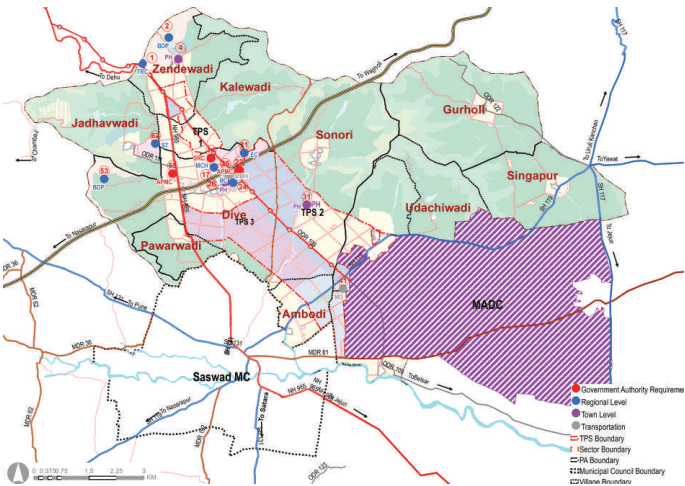
The role proposed for Saswad Growth centre is ‘Aerotropolis’.The rationale behind assigning this role to the GC is: 1. Because of it provides opportunity for green-field development abutting the new proposed CSR International Airport.
-
It can leverage upon the ecosystem that would then get flourished once the New International Airport activity commences.
-
Providing for new resident workforce for the during and post development of airport operations.
-
It provides opportunity to leverage upon the Aerotropolis ecosystem consisting of logistic park, agro & food processing cluster and business park.
-
In order to promote Fast Moving Consumer Goods (FMCG) due to its proximity to proposed CSR International Airport and connectivity via proposed MSRDC Ring Road.
-
Because of the High demand for commercial development likely to be generated by proposed extension to Metro (Hadapsar to New Airport) and 60m wide Airport Road.
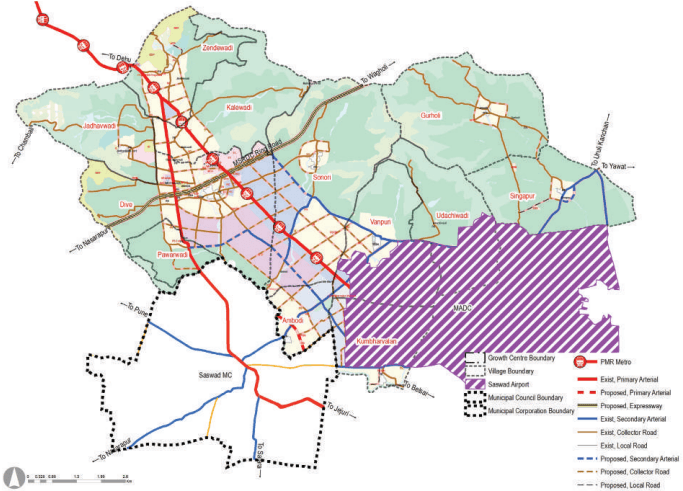
Understanding the above, transit-oriented linear development is proposed along the Airport Road, the Metro and the SH 120 which is deemed to be a National Highway with a major node at Dive. Saswad Growth Centre is proposed to be a vibrant growth centre with a balance mixed of activities and is expected to host majority of the logistic activities.
| Village | 2011 | 2018 | 2031 | 2041 |
|---|---|---|---|---|
| Ambodi | 650 | 652 | 4662 | 8673 |
| Dive | 3,484 | 5,517 | 10979 | 15562 |
| Gurholi | 1,941 | 1,948 | 1925 | 1902 |
| Jadhavwadi | 609 | 611 | 604 | 597 |
| Kalewadi | 1,404 | 1,527 | 5743 | 9905 |
| Kumbharvalan | 1,271 | 1,317 | 5394 | 9453 |
| Pawarwadi | 1,006 | 1,185 | 1247 | 1236 |
| Singapur | 1,177 | 1,221 | 1280 | 1321 |
| Sonori | 2,409 | 2,778 | 7179 | 11421 |
| Udachiwadi | 843 | 905 | 1003 | 1074 |
| Vanpuri | 1,079 | 1,149 | 5274 | 9369 |
| Zendewadi | 1,500 | 1,654 | 5925 | 10127 |
| Total | 17373 | 20465 | 51215 | 80641 |
Chapter 32: Growth Centre: Saswad
The proposed generated employment (URGD method) for Growth Centre for the year 2041 is 77,644 employees while the proposed residential density is about 125 ppl/ha (12500 p/sq km).
For the planning of public facilities distribution, the Saswad Growth Center is divided into two sectors. Sector 1 consists of Zendewadi, Jadhavwadi, Dive, Kalewadi, and Pawarwadi villages while sector 2 consists of Vanpuri, Udachiwadi, Gurholi, Ambodi, Kumbharvalan and Singapur villages.
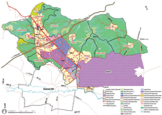
The boundaries of this planning division are shown on the Proposed Zoning Map. The projected sector-wise population statement is in Table 32.4
| Sector | 2011 | 2018 | 2031 | 2041 |
|---|---|---|---|---|
| Sector 1 | 8003 | 10,494 | 24498 | 37427 |
| Sector 2 | 9370 | 9971 | 26718 | 43214 |
| Total | 17373 | 20465 | 51215 | 80641 |
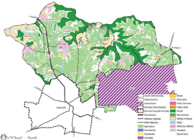
The proposed zoning would guide and determine the optimal and efficient land use for the next 20 years. The proposed zoning plan is an output of existing land use and physical conditions analysis, understanding of most pressing issues of the Growth Center, local knowledge of the place and deployment of five planning goals and allied physical planning strategies. The proposed zoning area statement is presented in Table 33.4.
Figure 32.4: Proposed Zoning Map
| Land use category | Area (ha) | Proportion of Total Devel-oped Area (%) | Proportion of Total Area (%) |
|---|---|---|---|
| Residential | 1054.85 | 43.25% | 14.24% |
| Gaothan | 40.68 | 1.67% | 0.55% |
| Commercial | 290.47 | 11.91% | 3.92% |
| Industrial | 324.67 | 13.31% | 4.38% |
| Public semi Public | 110.26 | 4.52% | 1.49% |
| Transport | 428.17 | 17.56% | 5.78% |
| Logistic Zone | 132.18 | 5.42% | 1.78% |
| Tourism | 49.46 | 2.03% | 0.67% |
| Public Utilities | 8.24 | 0.34% | 0.11% |
| Total Developed Area | 2438.98 | 100.00% | 32.92% |
| Afforestation Zone | 47.83 | 0.65% | |
| Agriculture | 2901.92 | 39.17% | |
| Forest | 1393.63 | 18.81% | |
| Hilltop Hillslope | 367.61 | 4.96% | |
| Green Belt | 6.75 | 0.09% | |
| Recreational | 103.08 | 1.39% | |
| Water Body | 149.13 | 2.01% | |
| Total Non-Developable Area | 4969.95 | 67.08% | |
| Total | 7408.93 | 100.00% |
The projected resident workforce based on the projected population through the URGD method is 44,122. Considering the proposed economic activities of all the growth centres, employment distribution was proposed based on the envisaged sectoral split for that Growth Centres. Accordingly, the employment to be generated for the Growth Centre for the year 2041 is estimated to be 77,095. The proposed residential density is about 125 PPH (12,500 persons/sq km).
Proposed zoning ensures that the sectoral development goals are clearly conveyed through it. Proposed sectoral goals and their corresponding physical planning strategies are mentioned in Table 32.6.
| Goals | Development Sector Addressed | Physical Planning Strategies |
|---|---|---|
| Prudent | Employment and housing | Work- Live Hubs |
| Convenient | Roads and mass transport | Movement Lattice |
| Resilient | Environment protection | Green- Blue connectors |
| Efficient | Infrastructure and utilities | Decentralized resource management |
| Self- sufficient | Social facilities | WalkableNeighbourhoods |
Chapter 32: Growth Centre: Saswad
For Saswad Growth Center, the Work-Live concept is applied by:
-
Envisioned as self-sustaining Aertropolise.
-
designating residential zones within 500m around industrial and commercial zones to minimize work related trips for at least 30% of the resident workforce;
-
Allocating 615.14 ha new industrial, and commercial zones along the Highway edging the MADC, to reduce travel time for commuting workforce from within & other Growth Centers
-
Regional Centre is proposed at Dive, at the central location of the Growth Centre
Out of the total proposed industrial zone over 18,660 Ha, industrial use over 230 Ha is envisaged in Saswad Growth Centre, both based on projected employment and 50 workers/ha density.
The industrial development is proposed considering a total 8973 employment by 2041, which further translates to 324.67 ha area of Industrial Zone, considering worker density of 50 workers/ ha and topping up by 30% (15% road, 10% open space, 5% amenity).The industrial zone as per ELU was 8.01 ha while there is no provision for industrial zone in RP 1997. The main purposed of locating industrial along the Airport road was to provide easy accessibility via Metro and promote the supportive infrastructure required for Aerotropolis.
Considering a 55 sqm built-up area/person, the total land requirements for the logistics zone for the Study area works out to be 2020 ha, out of which 100 ha is anticipated within the Saswad growth centre. However, taking into consideration the existing trend of warehousing and supplementary industries and the proposed strategic infrastructure projects, 132.18 ha.of logistic zone is proposed. This zone, being proposed along SH 119 and nearer to the junction of SH 119 and 60 m Primary Arterial Airport Road , Provides connectivity to the logistic centres of Ambodi and Kumbharvalan.
The planning intent is to leverage upon the upcoming international airport and support its ecosystem, ie supporting the FMCG, agro-processing and packaging industries.
Land requirement for the residential zone is estimated based on a net residential density of 125 PPH. Further, 45% add-on is considered to account for amenity (15%), open spaces (10%) and roads (20%). Accordingly, the total gross area required for the projected GC population of 80,641 by 2041 is estimated to be 940 Ha.
Considering the projected population, net residential density, proposed role and existing growth trends within the Growth Centre, 1054.85 Ha of gross residential zone is proposed.As per the Work Live hub concept, consolidated residential zoning is proposed in the Growth Centre. Residential development is proposed serving the industry and logistic areas of Dive and Sonori. Further residential development is proposed at Zendewadi along the Airport road and NH 965 (SH 120 Palakhi Marg).
Land requirement for commercial zone is estimated based on URDPFI guidelines i.e. 0.6 ha per 1000 population and topping up 30% (15% road, 10% open space, 5% amenity).The total commercial zone works out to be 63 Ha, while 290.47 Ha commercial zone is proposed to account for equitable distribution of commercial activities. Commercial node at Sonori, Dive and Zendewadi are proposed along the Metro corridor. Commercial development at Sonori is proposed to serve the logistic activities. The intent of proposing commercial zone along the Airport Road at Sonori and Dive, is to create a vibrant corridor of 1.5km along with retail and f&b activities. Regional Centre, Multimodal Hub and APMC are proposed centrally at Dive over government land. Another major commercial development is proposed at ‘Y’ junction at Zendewadi serving the residential development.