Malavali is envisioned as wellness tourism. The primary reason to assign this economic role to Malavali is to leverage the scenic natural setting in the area created by Sahyadri Hill ranges, rivers, lakes and backwater. It’s a land of great historical importance, with many forts skylining the southern side in Rural Mawal. The Indrayani River flows east-west through the centre of the area. The overall setup of the area is also conducive for the development of medical leisure and amusement parks. With good accessibility by Mumbai-Bangalore National Highway (NH-48), Yashwantrao Chavan Expressway and Pune-Lonavala Railway Line, the area attracts many tourists and trekkers as a gateway to nearby tourist spots.
Growth Centre Area
73.06sq km
Population
147,109 (2041); 126,130 (2031)
Net Population Density
100 PPH
Resident workforce
51,755 (2041)
Employment
19,988 (2041)
Households
29609 (2041)
Proposed Zones
Residential (1894.44), Commercial (97.31), Tourism Devlopment Zone (212.08 Ha.)
Promote tourism activities to develop employment not only for the Growth Centre population but also for people from the surrounding rural areas
Promote consolidated/ clustered development of tourism activities.
Protect the natural wilderness setting and the green ecosystem with consolidated eco-tourism activities
Promote luxury real estate with residential development enclosed by green and unscathed landscapes
Develop a grid network of secondary and tertiary roads for a smooth movement within the Growth Centre
Promote self-sufficient town by proposing required amenities and utilities for the projected population
Ropeway and Amusement Park at Kune Nm.
Tourist Centres at Kune NM, Mudhavare and Aundhe Kh
River Front Development and Regional Park along the Indrayani River at Karla near existing MTDC resort
Regional Park and Town Park at Karla along the Indrayani River
Tourism development along the hills, dams and existing adventure park
Biodiversity Park at Kune NM in hilly area.
Public Housing at Sadapur
Connecting road link between Mumbai Pune Expressway and National Highway 48.
28.3Proposed Role and Strategies
Malavali Growth Centre is envisioned as a wellness tourism leveraging upon following assets:
Presence of established scenic natural setting created by Sahyadri Hills, river, lakes and backwaters
The scenic natural setting created by hills and the Indrayani River that would be conducive for medical leisure
Historic heritage with many forts skylining the southern side in rural Mawal area.
Good accessibility by Mumbai-Pune Expressway, Mumbai-Bangalore National Highway and Pune-Lonavala Railway Line
Considering this, the following strategic projects are proposed:
Indrayani River Front Development.
Regional Park and Town Park at Karla along the Indrayani River
Tourist Centres at Kune NM, Mudhavare and AundheKh
Tourism Zoning at Kusgaon BK, Varsoli, AundheKh.
Socio Economic Projections
Table 28.3Population Projections
Village
2011
2018
2031
2041
Aundhekh.
1341
3,359
4,276
4,340
Aundholi
606
742
831
868
Bhaje
1835
3,116
3,985
4,310
Boraj
565
781
898
927
Devale
1358
2,929
3,640
3,692
Devghar
1161
1,558
1,844
1,967
Dongargaon
2331
3,100
5,005
7,026
Karla
2748
8,011
10,597
10,942
Kune N.m.
1954
13,798
19,156
19,446
Kusgaon Bk. (CT)
15612
22,571
36,795
50,324
Malvali
1439
2,829
4,196
5,123
Mudhavare
517
1,195
1,543
1,604
Patan
1727
2,819
3,939
4,720
Pathargaon
537
567
592
609
Pimploli
908
914
875
847
Sadapur
682
3,225
4,401
4,491
Taje
986
3,412
4,483
4,525
Varsoli
1533
6,546
8,875
9,064
Waksai
2511
6,700
10,200
12,284
Total
40,351
88,173
1,26,130
1,47,109
The projected resident workforce based on the projected population through the URGD method is 51,755. Considering the proposed economic activities of all the growth centres, employment distribution was proposed based on the envisaged sectoral split for that Growth Centres. Accordingly, the employment to be generated for the Growth Centre for the year 2041 is estimated to be 19,988 The proposed residential density is about 100 PPH (10,000 persons/sq km).
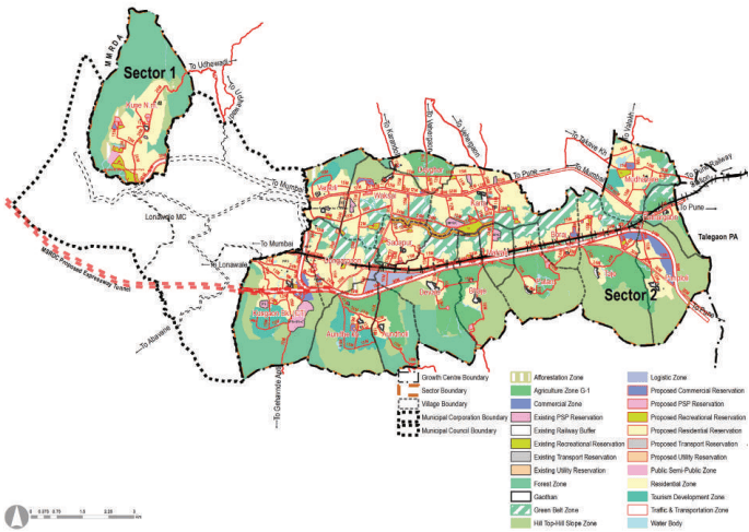
For the planning of public facilities distribution, Malavali Growth Center is divided into two sectors. Sector delineation is carried out based on the projected population distribution and physical boundaries. Kune NM forms the first sector since it is separated from the remaining GC villages. The second sector includes the remaining 18 villages. The boundaries of this planning division are shown on the Proposed Zoning Map. The projected sectorwise population statement is in Table 28.4.
Chapter 28: Growth Centre: Malavali
Table 28.4Projected Population - Sectors
Sector
2011
2018
2031
2041
Sector 1
1954
13798
19,156
19,446
Sector 2
38,397
74,375
106974
127663
Total
40351
88173
1,26,130
1,47,109
28.2Existing Situation Analysis
Malavali Center comes under Mawal taluka and comprises 19 villages, namely, AundheKh.,Aundholi, Bhaje, Boraj, Devale, Devdhar, Dongargaon, Karla, Kune NM, KusgaonBk, Malavali, Mudhavare, Patan, Pathargaon, Pimploli, Sadapur, Taje, Varsoli and Waksai. Total area of the Growth Centre is 7307 Ha. According to Census 2011, Malavali Growth Centre population was 40,351.
Malavali Growth Centre is blessed with a scenic natural setting. This, along with its robust connectivity with Pune and Mumbai, should be tapped into to unleash tourism potential. It has been recognized as a residential node in RP 1997, which has been successful in attracting luxury real estate development. However, most of this area has not developed due to the Indrayani blue line.
Malavali Growth Centre is in the western part of PMR, along the Mumbai-Pune Expressway. It shares a boundary with Talegaon Growth Centre on the east, Lonavala Municipal Council on the west, MMRDA boundary at northwest and rural areas of Mawal Taluka on the north and south. Western Ghat villages make the southern boundary of the GC. It is connected with Pune by Mumbai-Bangalore National Highway (NH-48), Mumbai Pune Expressway and Pune-Lonavala Railway Line. It is 51 km from Pune city.
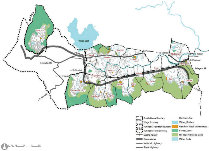
In terms of physiography, most of the area in Malavali has flat terrain with hills forming the southern boundary. The Indrayani River divides the Growth Centre into northern and southern segments. The southern part of the growth centre is covered with hills and forest. Kune N.M., Aundholi, Bhaje, Patan, Pimpaloli, Boraj villages are from the Western Ghats region. Valvan dam lies in the northwest, adjacent to the Growth Centre. The Kune NM village is separated from the remaining villages due to Lonavala Council. Hills cover 75% of the part of Kune NM, with a plateau development.
Figure 28.1: Location and Physiography
Chapter 28: Growth Centre: Malavali
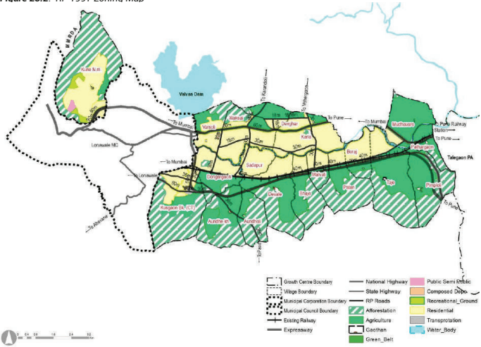
Malavali Growth Centre includes part of Sector NOR of RP 1997. It recommended a residential node in the area, and the development of tourism activities was expected. It proposed residential zoning inbetween Pune-Lonavala Railway Line and Mumbai-Bangalore Highway NH48 . It allowed built-up up to 25% in Sector NOR, with up to G+1 storey buildability.
RP 1997 proposed afforestation on existing forest lands as well as adjoining hilly barren lands. It also proposed a 30 m green belt on both side of Indrayani River.
Major transport proposal in RP 1997 includes widening of Mumbai-Bangalore National Highway. It kept 75 m RoW on each side for the tree plantation. It also proposed a 40 m wide road on the northern side of the Pune-Lonavala Railway Line. Residential areas were proposed to be linked with a network of 30 m and 18 m wide roads with the provision of level crossing and flyover.
Figure 28.2: RP 1997 Zoning Map
Table 28.1RP area Statement
Land use category
Area (ha)
Proportion of Total De-veloped Area (%)
Proportion of Total Area (%)
Residential
1920.10
82.72%
26.44%
Commercial
0.00
0.00
0.00
Industrial
0.00
0.00
0.00
Public and semi public
12.05
0.52%
0.17%
Garden, Playground and Recreation
42.37
1.83%
0.58%
Public Utility
3.64
0.16 %
0.05%
Transportation
342.97
14.78%
4.72%
Defense
0.00
0.00
0.00
Total Developed Area
2321.13
100.00%
31.96%
Agriculture
1946.14
26.80%
Afforestation
2768.98
38.13%
Green Belt
144.53
1.99%
Water bodies
81.61
1.12%
Forest
0.00
0.00
Total Undeveloped Area
4941.25
68.04%
Total Area
7262.38
100.00%
Existing Land Use
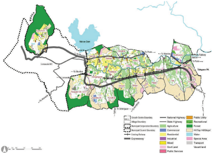
The natural beauty possessed by the Growth Centre and its strong connectivity with Pune and Mumbai has led to the development of luxury real estate in the area. The total area of the Growth Centre is 7307 Ha, with forest and hilltop hill slope combined amounting to 34% of the total area. The majority of residential developments are seen along the Mumbai-Bangalore Highway (NH-48) and around Lonavala Municipal Council. Commercial developments are also seen along the NH-48, albeit in small clusters. The total area under water body’s amounts to 2%, with the Indrayani River flowing through the central part of the GC and area under blue line is 9.35 %. Government lands are spread around in the Growth Centre, amounting to approximately 3.46 % of the total area. The majority of government lands are hilly and non-buildable.
Figure 28.3: Existing Land Use Map
Chapter 28: Growth Centre: Malavali
Table 28.2Existing Land Use Area Statement
Land use category
Area (ha)
Proportion of Total Developed Area (%)
Proportion of Total Area (%)
Residential
700.15
45.23%
9.58%
Commercial
82.85
5.35%
1.13%
Industrial
2.88
0.19%
0.04%
Mixed
16.01
1.03%
0.22%
Public and semi public
357.58
23.10%
4.89%
Garden, Playground and Recreation
76.64
4.95%
1.05%
Public Utility
2.33
0.15%
0.03%
Transportation
309.48
19.99%
4.24%
Defense
0.00
0.00
0.00%
Total Developed Area
1547.92
100.00%
21.18%
Agriculture
1297.46
17.76%
Water bodies
174.53
2.39%
Vacant Land
1806.35
24.72%
Forest
1144.55
15.66%
Hill Top Hill Slope
1320.17
18.07%
Special Areas
16.06
0.22%
Total Undeveloped Area
5759.12
78.82%
Total Area
7307.04
100.00%.
Unplanned and sporadic tourism activities
Sporadic development around Lonavala Municipal Council area, mainly along the existing roads
Residential zoning as proposed under RP 1997 has not developed due to the blueline of the Indrayani River
Absence of sewerage, storm water drainage and solid waste management sites
Encroachments on hilltop hill slopes
28.4Proposed Zoning
The proposed zoning would guide and determine the optimal and efficient land use for the next 20 years. The proposed zoning plan is an output of existing land use and physical conditions analysis, understanding of most pressing issues of the Growth Center, local knowledge of the place and deployment of five planning goals and allied physical planning strategies. The proposed zoning area statement is presented in Table 28.5.
Figure 28.4: Proposed Zoning Map
Table 28.5Proposed Zoning Area Statement
Land use category
Area (ha)
Proportion of Total Devel-oped Area (%)
Proportion of Total Area(%)
Residential
1894.44
64.61%
25.94%
Gaothan
42.25
1.44%
0.58%
Commercial
97.31
3.32%
1.33%
Logistics
50.59
1.73%
0.69%
Tourism Development
212.08
7.23%
2.90%
Public and semi public
109.30
3.73%
1.50%
Public Utility
7.91
0.27%
0.11%
Traffic & Transportation
518.15
17.67%
7.09%
Total Developed Area
2932.01
100.00%
40.15%
Agriculture (G1)
693.64
9.50%
Water bodies
146.28
2.00%
Green Belt
692.03
9.48%
Forest
1154.26
15.80%
Hilltop Hillslope
1524.37
20.87%
Recreational
101.50
1.39%
Afforestation
59.47
0.81%
Total Non-Developable Area
4371.54
59.85%
Total
7303.55
100.00%
Translating Goals into the Plan
Proposed zoning ensures that the sectoral development goals are clearly conveyed through it. Proposed sectoral goals and their corresponding physical planning strategies are mentioned in Table 33.5.
Table 28.6Goals and Physical Planning Strategies
Goals
Development Sector Addressed
Physical Planning Strategies
Prudent
Employment and housing
Work- Live Hubs
Convenient
Roads and mass transport
Movement Lattice
Resilient
Environment protection
Green- Blue connectors
Efficient
Infrastructure and utilities
Decentralized resource management
Self- sufficient
Social facilities
Walkable Neighbourhoods
Prudent: Work-Live Hubs
For Malavali Growth Center, the Work-Live concept is applied by:
Designating tourism zones and promoting tourism activities to foster employment generation for the local population
Designating residential zone to serve the hospitality and entertainment sector for at least 30% of the residential workforce
Allocating commercial zones within scenic settings at two different nodes along the Expressway, complementing tourism activities
Chapter 28: Growth Centre: Malavali
Tourism Development Zone:
Malavali is well known for its scenic and unscathed landscape and copious amusement parks. With good connectivity to Pune and Mumbai, by road as well as rail, it attracts tourists throughout the year. It is also a gateway to trekker’s paradise, with numerous forts and hill ranges. Tourism zoning is proposed at four nodes, i.e. Mundhavare, Aundhe Kh, Kusgaon Bk and Varsoli, to encourage clustered development tourism activities. The nodes at villages Mundhavare and Kusgaon Bk can develop into amusement parks and media theme parks. The tourism node at Aundhe Kh serves the purpose of protecting the hills and forts on the south from human exploitation and helps in a consolidated development of tourism activities. The tourism zone at Varsoli is proposed in the vicinity of the Valvan dam. It will promote wellness centres with its serene and isolated setting.
The total logistic land use requirement of the Study Area is estimated to be 20.2 sq km considering projected demographics and area requirement of 55 sqm built-up area per person. 100 Ha. of this estimated area is anticipated in Malavali Growth Centre. However, considering the proposed role of the GC, the prevailing trend of warehousing and supplementary industries and the proposed strategic infrastructure projects, logistic use is proposed over 50.59 Ha.
The intent is to develop consolidated logistics parks at strategic locations to avoid negative impact on surroundings and improve efficiency and economies of scale for logistics operations. In light of this, the logistic zone is proposed centrally at villages Devale, Aundhe KH, Dongargaon. It is connected to Malavali Railway station, NH48 and Mumbai Pune Expresswayway.
Land requirement for the residential zone is estimated based on a net residential density of 100 PPH. Further, 45% add-on is considered to account for amenity (15%), open spaces (10%) and roads (20%). Accordingly, the total gross area required for the projected GC population of 1,47,109 by 2041 is estimated to be 2130 Ha
Considering the projected population, net residential density, proposed role and existing growth trends within the Growth Centre, 1894.44 Ha of gross residential zone is proposed. As per the Work Live hub concept, consolidated residential zoning is proposed in the Growth Centre. Residential zone other than Regional Plan residential zoning is extended towards southern side of Railway line at village Kusgaon Bk., Dongargaon, Taje and Pimploli. A new residential node is introduced at Mundhaware.
Land requirement for the commercial zone is estimated based on URDPFI guidelines, i.e. 0.6 ha per 1,000 population. Add on of 30% is considered to account for roads (15%), open spaces (10%) and amenities (5%). Accordingly, commercial zone works out to be 115 Ha, while 97.31 Ha commercial zoning is proposed Commercial zoning is proposed at three locations along the Pune-Mumbai Expressway to complement tourism activities. A town centre is also proposed along the Expressway on government land at one of the commercial nodes in Boraj village.
28.128.9 Proposed Reservation Statement, Costing and Phasing
Table 28.10Proposed Reservation Statement
No
Purpose of Reservation
Planning Standard
Total Requirement
Existing/Available
Proposed Reservations
Total Reservations
Area
Min unit required
No of sites
Area in Ha
No of sites
Area in Ha
No of sites
Area in Ha
No of sites
Area in Ha
Neighbourhood level
1
Primary School (I-V)*
1/5000ppl, 1/500 students, 1/5000popula-tion
1/500 students
25
10
29
16.72
3
2.28
32
19.00
2
Secondary School (VI-XII)*
1/10000ppl, 1/1000students1/10000popula-tion
1/1000 students
13
13
8
13.83
4
5.14
12
18.97
3
Health Centre
1/15000ppl,
1HC / 15,000 population
8
1
2
0.18
5
0.74
7
0.92
4
Community Hall
1/15000ppl,
1 /15,000 popula-tion
8
2
0
0
5
1.33
5
1.33
5
Garden
1/15000ppl,
1/15000 population
8
8
1
0.69
10
15.91
11
16.60
6
Playground
1/15000ppl,
1/15,000 population
8
13
0
0
12
12.74
12
12.74
7
Shopping Centre/Market
1/15000ppl,
1/15,000 population
8
4
0
0
4
1.92
4
1.92
Town Level
8
College
1/1.25lac ppl, 1000-1500students
1000 - 1500students
1000 - 1500students
1
5
5
20.78
0
0.00
5
20.78
8
College
1/1.25 lakh population
1
5
5
20.78
0
0.00
5
20.78
9
Hospital / Trauma Care Centre
1/ 1 lac ppl,
1/100,000 popula-tion
1/100,000 popula-tion
1
1
0
0
2
3.24
2
3.24
10
Socio-Cul-tural Centre
1/1lac,
1
1
0
0
2
1.48
2
1.48
11
Town Park
1/ 1 lac,
1/ 1Lakh
1/ 1Lakh
1
5
0
0
1
17.00
1
17.00
12
Town Centre
1/ 1 lac,
1 / 1 lakh
1 / 1 lakh
1
5
0
0
1
4.36
1
4.36
13
Sports Complex
1/ 1 lac,
1 / 1 lakh
1 / 1 lakh
1
5
0
0
1
3.84
1
3.84
14
Burial Ground
1/5 lac,
1 site/ 5 lakh,
1 site/ 5 lakh,
0
0
3
2.98
0
0.00
3
2.98
15
Cremation Ground
1/5 lac,
1 site/ 5 lakh,
1 site/ 5 lakh,
0
0
7
0.82
0
0.00
7
0.82
No
Purpose of Reservation
Planning Standard
Planning Standard
Planning Standard
Total Requirement
Total Requirement
Existing/Available
Existing/Available
Proposed Reservations
Proposed Reservations
Total Reservations
Total Reservations
Area
Min unit required
Min unit required
No of sites
Chapter 28: Growth Centre: Malavali
Table 28.11Cost and Acquisition Statement for Proposed Reservations
Res-erva-tion No.
Purpose of Reservation
Taluka
Village Name
S. No/ Gut No./ CTS No./F.P.No
Area (ha)
Land Own-ership(Govt/GP/PMRDA/Private)
Total <sub>Cost</sub> <sup>of</sup> <sub>Acqui</sub>-sition (INR Cr)
Total Cost of Devel-opment (Const.) (INR Cr)
Total Cost (INR Cr.)
Appro-priate Authority
1
Rope Way and Amus-ment Park
Mawal
Kune N.m.
147
28.7
Govern-ment
0
53.35
53.35
PMRDA
2
Garden
Mawal
Kune N.m.
54B, 54A
1.41
Private
15.3
4.1
19.39
PMRDA
3
Play ground
Mawal
Kune N.M
93P
1.44
Govern-ment
0
2.9
2.9
PMRDA
4
Social-Cul-tural Centre
Mawal
KuneN.m
93P
1.11
Govern-ment
0
28.98
28.98
PMRDA
5
Tourist Centre
Mawal
Kune N.M
93P, 68B
1.98
Govern-ment
0
51.9
51.9
MTDC
6
Authority Purpose
Mawal
Kune N.M
93P, 68B
2.05
Govern-ment
0
38.72
38.72
PMRDA
7
Health Centre
Mawal
KuneN.m
109P
0.13
Amenity Space
0
3.2
4.59
PMRDA
8
Primary School
Mawal
Kune N.M
108P, 109P
0.42
Amenity Space
0
7.92
11.49
PMRDA
9
Authority Purpose
Mawal
Kune N.M
135P, 116P
2.55
Amenity Space
0
48.05
69.72
PMRDA
10
Community Hall
Mawal
Kune N.M
88P
0.21
Amenity Space
0
5.4
Chapter 28: Growth Centre: Malavali
Res-erva-tion No.
Purpose of Reservation
Taluka
Village Name
S. No/ Gut No./ CTS No./F.P.No
Area (ha)
Land Own-ership(Govt/GP/PMRDA/Private)
Total <sub>Cost</sub> <sup>of</sup> <sub>Acqui</sub>-sition (INR Cr)
Phase I (Reser- Phase II (Reser vation No) vation No)
- Phase III (Res- Phase IV (Res- Phase V (Reser-ervation No) ervation No) vation No)
1
Primary School (I-V)*
8,17
2
Secondary School (VI-XII)*
31, 65
16
3
Primary School Extension
43, 53, 67,71 54
4
Primary School +Secondary School
38
5
Health Centre
15, 28, 48, 66, 7
6
Community Hall
10, 29, 47, 64,73
7
Garden
11, 34, 39, 41,60, 68
2, 13, 25, 76
8
Playground
3, 46 50, 56, 58, 62
14, 24, 26, 33,70, 75
9
Shopping Centre/ Market
23, 74, 37, 59
Regional level
Town Level
10
Hospital
72
11
Public Housing
63
44
12
Socio-Cultural Centre
4, 61
13
Trauma Care Centre
20
14
Town Centre
36
15
Town Park
30
16
Sports Complex
21
17
Fire Brigade Station
51
21
Sewerage Treatment Plant
12
32,45
22
Water Works (Water Treatment Plant, Tanks and Pipes)
77
18
23
Authority Purpose
6,9
55
24
Public Amenity
49
25
Government Purpose
40
35, 52, 57
26
Lonawala Upbazar
19
27
Bus Depot / Terminal
27, 55
30
River Front Development
22
32
Tourist Center
5, 42, 69
Total Cost of development of Reservations of UGC : Malavali
Total Acquisition cost of Reservations ( in Rs.CR.)
Total Construction cost of Reservations ( in Rs.CR.)
Total Cost of development of Reservations( in Rs.CR.)
Road construction cost
Total Development Cost
Reservation on Amenity Space/TP scheme/Government (A)
0.00
1137.63
1137.63
1051.00
2557.32
Reservations on Private land
204.00
533.37
737.37
50% of the total cost of reservations on private land with an assumption that 50% of reservations will be developed through TDR/AR & In-situ FSI (B)
102.00
266.69
368.69
Total Cost (A+B)
102.00
1404.32
1506.32
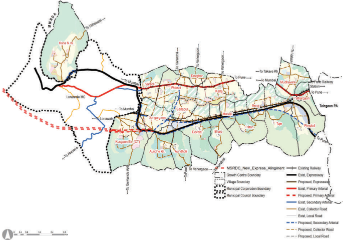
The movement lattice concept also includes a mass transit corridor running through the Growth Center centre. This growth center is connected through the existing railway line, old Mumbai Pune road . 30m wide service roads are proposed on both sides of the existing Expressway to connect all villages along Expressway within GC as well as to adjacent GC.
A road parallel to the Pune-Lonavala Railway Line is proposed for better traffic movement in residential areas. This road was proposed in RP but not developed completely.
MSRDC has proposed alternate tunnel road for certain portion of the Mumbai-Pune Expressway to bypass the Lonavala Municipal Council area and the Khandala Ghat portion of the Expressway. The same has been incorporated.
Secondary road connectivity is proposed through 3 links:
a. 30 m wide RP Road connecting NH-48 and Pune-Lonavala Railway Line through village Waksai, Sadapur and Dongargaon is further extended up to Expressway.
b. MDR 25 is also act as secondary connectivity , it was 30m as per RP, has been proposed as 24m wide link due to existing structures along it.
c. 30m RP road passing through Varsoli and Dongargaon is maintained as it is.
30 m service roads are proposed on both sides of Mumbai-Pune Expressway for accessibility & development of adjoining lands.
Tertiary Road Connectivity is achieved by grid of approximately 500m to 1000m.
All proposed roads are to be designated with at least 3m wide footpath on either side of the road, as the ‘pedestrian right of way’ and ‘hawker-free zone.’
Figure 28.5: Proposed Transport Network Map
Table 28.7Proposed Transport Network Statement
Road Category R RoOaWds names/
Proposed ROWs
Authority
Total Length Cost of Road Devel-(km) opment
Primary
Expressway
90
MSRDC
15.57
NH48
60
NHAI
8.47
Secondary
SH126
45
PWD
0.15
MDR107
30
PWD
0.19
MDR25
30
PWD
0.11
Tertiary
MDR25
24
PWD
3.05
MDR26
24
PWD
4.12
MDR107
24
PWD
2.67
Chapter 28: Growth Centre: Malavali
MDR146
24
PWD
4.38
VR173
24
ZP
0.40
MDR25
18
PWD
3.62
MDR26
18
PWD
1.93
MDR107
18
PWD
4.52
Local
MDR107
15
PWD
0.80
ODR65
15
ZP
1.48
VR (Total)
15
ZP
6.01
MDR107
12
PWD
0.09
VR (Total)
12
ZP
0.22
MDR25
9
PWD
0.32
MDR107
9
PWD
0.91
VR (Total)
9
ZP
0.55
59.55
DP Roads
Primary
Secondary
Service Road
30
PMRDA
20.32
287.69
30
PMRDA
4.00
56.63
Tertiary
24
PMRDA/Proposed ULB
20.40
248.68
18
PMRDA/Proposed ULB
9.51
77.49
15
PMRDA/Proposed ULB
45.73
338.88
Local
12
PMRDA/Proposed ULB
5.99
41.38
9
PMRDA/Proposed ULB
0.21
0.63
Total Road Length
106.16
1051.39
Resilient: Green-Blue Connector
The existing forest areas at 161.61Ha are designated as protected areas.
Afforestation zone is proposed near Valvan dam.
Green Belt zoning is proposed between the riverbank of the Indrayani and its blue line.
All existing streams to be protected.
These protected Green-Blue features are recommended to be connected by a 30-45 m wide secondary arterial road that would be upgraded as a tree-lined avenue by developing NMT corridors (>3 m each) on both sides of the road and segregated from footpaths.
Green lungs are proposed within 500 m walkable distance covering an area of 799.53 ha. These green lungs include active and passive recreational spaces. The total active recreational space works out to be 16.52 ha
that include playgrounds, sport complex, stadium and multi-purpose ground. And the total passive recreational space works out to be 783 ha that include gardens, town park/ regional park, bio diversity park and green belt.
Table 28.8Proposed Infrastructure Demand
Infrastructure System
Demand (2041)
Unit
Required Area(Ha)
Utility Sites
Total Area (Ha)
Water Supply
10.66
MLD
0.19
2 WTPs
0.3
Sewerage
10.59
MLD
1.59
3 STPs
2.22
Solid Waste
44.13
Tones/day
-
-
-
This concept is applied as follow:
3 WTP (0.69 Ha) site is proposed on government land at village Patan.
STPs are provided considering the topography and gravity systems . Three STPs (2.22 ha) are provided for the Growth Centre and are located at Dongargaon and Taje villages, away from the residential development on the bank of the Indrayani River.
Existing Dumping Depot site of 3.63Ha was reserved in RP at village Varsoli.
A fire station of 0.44 Ha is provided along the NH-48. Existing crematorium and burial grounds are maintained and expanded wherever required and feasible
This goal is set to increase the liveabilty index of the Growth Centre. To do that, amenities are proposed within 500 m distance, leveraging the concept of Walkable Neighbourhoods. The concept entails providing basic infrastructure and services for education, health, sports, and recreation within the neighbourhood to have easy access to them by foot.
Amenity provision is made for the projected population by 2031 (1,26,130 people)
Neighbourhood level amenities are located within a 500 m – 800m radius from residential zones and are connected by collector/local roads to improve their accessibility from other neighbourhoods.
Town level amenities are distributed across the Growth Centre and are accessible by mass transit modes such as bus system.
Education: Existing schools are well serving the GC and only one Primary + secondary school is proposed at village Taje; expansion to the 6 existing ZP schools are proposed with proper road access to each of the amenity.
Health: Health Centres (5) are provided considering walking radius within a Neighbourhood. One hospital at Dongargaon on government land and one trauma care centre along NH48 on amenity space are proposed.
• Socio-Cultural: Community halls (5) are provided considering walking distance within a neighbourhood. Two
Chapter 28: Growth Centre: Malavali
socio-cultural centres are provided at Kune NM and Sadapur.
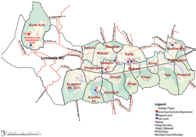
Open Space: 50 m wide belt along Indrayani river is reserved as River front development at village Waksai, Karla, Sadapur, Devale, Bhaje And Malavali; 1 Town Park proposed adjoining to it and near to existing MTDC resort. Gardens and Playgrounds are proposed near schools and are split into 2 with a minimum area of 0.8 ha to improve spatial distribution wherever required; Garden, provided along/ near water bodies, within green belt or on Government owned plots. Spatially distributed 10 Neighbourhood Gardens and 12 Playgrounds, along with 15m wide greenbelt to the periphery of existing water body is proposed at village Kune N.M. A sports complex is provided in Sadapur village.
Commercial: Shopping Centre/market is provided at existing commercial nodes or near existing settlements or on available amenity spaces. Town Centre is provided at village Boraj in proximity to Railway station and Pune-Mumbai Express highway.
• Residential: Public housing of 1.67 Ha is proposed at Sadapur village on Government land, covered under the PMAY scheme.
Transport: Two bus depots are provided for the Growth Centre - one in village Karla along the NH-48 and another in village Bhaje, near Malavali Railway station.
Civic: Two Tourist centers of 4.58 Ha at Mundhavare near existing water body and 2.79 Ha at village Aundhe Khurd are proposed in newly proposed Tourism zone.
Civic facilities requested by various government authorities: In addition to the above amenities, an APMC market is proposed at village Waksai . Further, Tourism Information Centre & Tourist Residence of 3.40Ha is proposed at Kune NM for MTDC.
Table 28.9Summary of Land Ownership of Proposed Amenities
Land Ownership
No of Amenity
Total Area (ha)
Government Land
27
77.38
Private Land
25
48.56
Amenity Space
18
17.19
Other
7
28.81
Total
77
171.95
Implementation Strategy for the Proposed Reservations
The proposals/reservations of the Development Plan are proposed to be acquired and developed through the mechanism of Accommodation of Reservation and Transfer of Development Rights (TDR) policy. It is estimated that all proposed roads and 50% of the public reservations will be acquired through TDR/FSI/AR.
The remaining reservations will be acquired under the provision of the Land Acquisition Act by paying monetary compensation.
Figure 28.6: Strategic Projects
Legend Strategic Project Government Authority Requirement Regional Level Town Level -Railway Village Boundary Road_Malavali -PA Boundary Municipal Council Boundary
CCC
Chapter 28: Growth Centre: Malavali
Area in Ha
No of sites
Area in Ha
No of sites
Area in Ha
No of sites
Area in Ha
16
Fire Brigade Station
1 in each growth centre
As per requirement of Fire department of PMRDA. 1 Fire station / growth centre
As per requirement of Fire department of PMRDA. 1 Fire station / growth centre
1
0.4
0
0
1
0.45
1
0.45
17
Solid Waste Management Site
1 site per PA /
1 site per growth centre
1 site per growth centre
1
5
1
3.42
0
0.00
1
3.42
18
Sewerage Treatment Plant
Land area requirement is as per URDPFI i.e. For activated Sludge Process (ASP)-0.15 Ha/MLD
Land area requirement is as per URDPFI i.e. For activated Sludge Process (ASP)-0.15 Ha/MLD
1
2
0
0
3
2.22
3
2.22
19
Water Works (Water Treatment Plant, Tanks and Pipes)
Water requirement of PMR is 72 lpcd as per Report 'Integrated Master Plan Of Water Supply, Sewerage, Storm Water and Solid Waste Management in the PMR'. It is distributed to each Growth center.
Water requirement of PMR is 72 lpcd as per Report 'Integrated Master Plan Of Water Supply, Sewerage, Storm Water and Solid Waste Management in the PMR'. It is distributed to each Growth center.