Wagholi Growth Center comes under Haveli taluka and comprises ten villages, namely, Awhalwadi, Loni-Kand, Kesnand, Bakori, Bhavadi, Taleranwadi, Perane, Phulgaon, Wadhu Kh and Wagholi. According to Census 2011, Wagholi Growth Centre population was 71,341 in 2011, and the estimated population for 2018 is 1,70,206 with 23,668 employed.
Wagholi Growth Centre enjoys great locational advantage with its proximity to adjoining PMC developments, Kharadi IT Park, Lohegaon Airport and Pune-Ahmednagar Highway (NH-753F), one of the busiest national highways in PMR. RP 1997 recognized Wagholi as a residential node which was successfully implemented with subsequent planned layout developments.
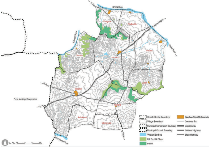
Wagholi Growth centre is located on the northeastern side of Pune Municipal Corporation along the Pune-Ahmednagar Highway (NH 753 F) within Haveli taluka. It is surrounded by Alandi Growth Centre on the northwestern side, Loni Kalbhor on the south side, PMC area on the south-western edge and Shikrapur Growth Centre on the northeastern front.
Wagholi Growth Center is abutting the PMC boundary, and it is 21 Km from PCMC. It extends almost 3.5 km on both sides of the NH 753F. SH-115 and NH 548DD connect Wagholi Growth Centre to Markal on north and Solapur Highway on south via Lonikand, Kesnad and Theur. NH 548DD further connects to Vadki and Uruli Devachi. Thus it connects the industrial development of Markal, Lonikand, Kunjirwadi and Vadki, providing an alternative to the PMRDA Ring Road. SH-68 provides fast connectivity to Lohegaon Airport, thus increasing opportunity for the hospitality industry and IT segment.
The northwestern part of the area is covered by quarry activity, creating a distinct edge between Alandi Growth Centre and Wagholi Growth Centre. Some of the northern part of the Growth Centre is under the forest zone, whereas the central-eastern edge has slopes. Wagholi Growth Center touches three rivers such as Indrayani River north-west side, the Bhima River north-east side and the Mula-Mutha River on its south-west side. Almost 33% of the land is under agricultural use. 337.43 ha of forest land is present in the northern edge of Kesnand and Lonikand villages and the southern edge of Phulgaon
Chapter 22: Growth Centre: Wagholi
Figure 22.1: Location and Physiography
Regional Plan 1997 Analysis
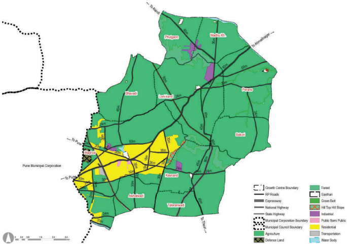
Wagholi Growth Centre includes part of RP 1997 Sectors such as Sector H and Sector PMR. The main concept of Sector H was to propose a residential zone, serving industrial nodes of Koregaon Bhima-Sanaswadi and MIDC’s at Vadgaon Sheri and Kharadi. Thus in the proposed boundary of the Growth Centre, the majority of Residential development is observed between the two bypasses proposed for Ahmednagar Road (NH 753 F) within the Regional Plan. The entire proposed residential zone was implemented and further spilled in Wagholi, Awhalwadi villages. Thus the residential trend is observed in this Centre.
Industrial zone proposed at Lonikand over 45 ha is observed to have been realised. This industrial area developed into a number of small scale units located along the NH 753F. The agriculture zone proposed over 8,745.46 ha in the Regional Plan 1997 dominates the Growth Centre.
Figure 22.2: RP 1997 Zoning Map
| Land use category | Area (ha) | Proportion of Total Devel-oped Area (%) | Proportion of Total Area (%) |
|---|---|---|---|
| Residential | 1081.81 | 60.6 | 9.79 |
| Commercial | 0 | 0.0 | 0.00 |
| Industrial | 113.4 | 6.3 | 1.03 |
| Public and Semi public | 16.93 | 0.9 | 0.15 |
| Public Utility | 0 | 0.0 | 0.00 |
| Transportation | 525.54 | 29.4 | 4.76 |
| Defense | 48.85 | 2.7 | 0.44 |
| Total Developed Area | 1786.53 | ||
| Agriculture | 8777.82 | 79.17 | |
| Water bodies | 144.2 | 1.31 | |
| Hill Top Hill Slope | 27.76 | 0.25 | |
| Forest | 370.16 | 3.35 | |
| Total Undeveloped Area | 9259.82 | ||
| Total Area | 1178.8 |
Chapter 22: Growth Centre: Wagholi
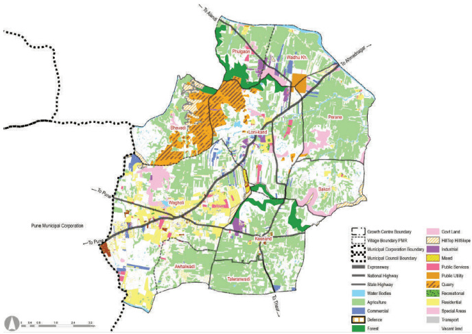
Wagholi town has rapidly developed along the NH 753F due to proximity to PMC, Kharadi IT Park, Lohegaon Airport and Shikrapur industrial area. The majority of the Growth Centre land is under agriculture (33.3%), with built-up areas concentrated around Wagholi Gaothan, Kesnand, Awhalwadi, Lonikand and along the NH 753F.
The total area of Wagholi Growth Center is about 110.78 sq km. Almost 35 % of the entire existing land is vacant land, followed by agriculture land, which is 33.3 %. The area under forest is 337.5 ha. which is almost 3 %, while the area under water bodies is roughly 2 %. It is observed that commercial and residential areas are 1.74 % and 7.3 %, respectively. ELU shows industrial and commercial corridor development majorly along the NH 753F. Residential nodal development is seen in Wagholi, whereas Lonikand, Perane, Awhalwadi, and Kesnand are dotted by residential developments and some areas by unplanned settlements. Public utilities and amenities together contribute about 0.69% only of the existing land use. This Growth Centre has a well known historical temple, Wagheshwar temple, along the national highway situated at Wagholi village. Government-owned lands are present in Lonikand, Perane, Wadhu Kh and along the NH-753F in Wagholi.
A number of stone quarries spread across Wagholi Growth Centre in villages of Wagholi, Bhavadi, and Lonikand, has been depleting the air quality of the region. The total area of the Wagholi quarry alone is about 5.75 sq km. It offers a tremendous opportunity to re-purpose the quarry land for recreational activities, water reservoirs and safeguarding the bio-diversity generated within the abandoned quarry lands.
The majority of Wagholi Growth Centre comes under the Blue zone of Air Force Restriction Zone, where NOC is exempted if the top elevation is 627 m AMSL or below. 460 ha of the area is observed under the red zone, limiting the development potential of the area.
Figure 22.3: Existing Land Use Map
| Land use category | Area (ha) | Proportion of Total Devel-oped Area (%) | Proportion of Total Area (%) |
|---|---|---|---|
| Residential | 811.34 | 78.38 | 7.34 |
| Commercial | 192.14 | 18.56 | 1.74 |
| Industrial | 106.55 | 10.29 | 0.96 |
| Public and semi public | 411.78 | 39.78 | 3.73 |
| Garden, Playground and Recreation | 17.07 | 1.65 | 0.15 |
| Public Utility | 59.28 | 5.73 | 0.54 |
| Transportation | 283.1 | 27.35 | 2.56 |
| Mix use | 48.79 | 4.71 | 0.44 |
| Special Areas | 108.62 | 10.49 | 0.98 |
| Defense | 0.01 | 0.00 | 0.00 |
| Total Developed Area | 1035.2 | ||
| Agriculture | 3717.72 | 33.36 | |
| Water bodies | 227.44 | 2.06 | |
| Vacant Land | 3923 | 35.51 | |
| Quarry | 575.16 | 5.21 | |
| Forest | 337.82 | 3.06 | |
| Hill Top Hill Slope | 227.28 | 2.06 | |
| Total Undeveloped Area | 10011.15 | ||
| Total Area | 11078.82 |
-
Traffic congestions along the NH-753F, no bypass developed
-
Critical junctions: at Wagholi Gaothan, SH-68 and NH-753F junction, NH-548 DD and NH-753F junction
-
Scattered development within Wagholi and Kesnand
-
Absence of sewerage, stormwater drainage and solid waste management sites
-
460 ha area under the red zone of Airforce restriction
-
Non-developable 5.75 sq km Quarry land