Pirangut Growth Center is a part of Mulshi taluka comprising 13 villages: Bavdhan (BK), Sus, Bhugaon, Lavale, Nande, Pirangut, Kasar Amboli, Mukaiwadi, Uravade, Bhare, Ambarwet, Ambegaon and Bhukum. Its total area is 109.73 sq km. According to the Census 2011, the population of Pirangut Growth Centre was 61,111 and the estimated population for 2018 is 1,62,852 with 37,344 employment.
The Growth Centre has several premier university campuses. Further, it enjoys good regional connectivity through Mumbai-Bangalore National Highway (NH-48) and Pune - Kolad National Highway (NH-753F)
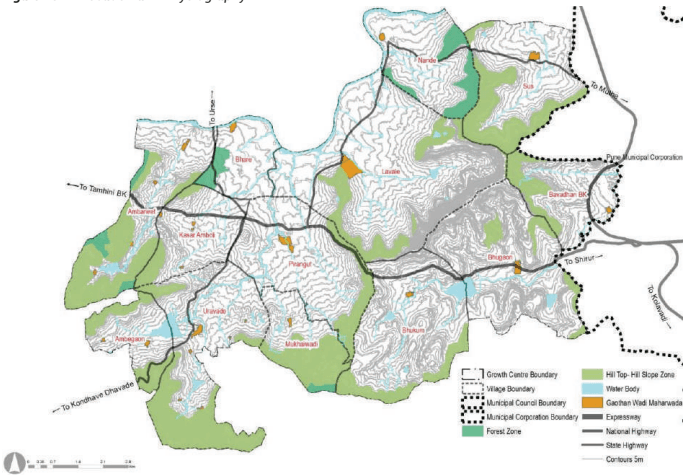
Pirangut Growth centre is located on the west side of PMR along the Pune-Kolad National Highway (NH-753F). It shares its eastern boundary with Pune Municipal Corporation. Mula River abuts it on the north, National Defence Academy on the south and hilly rural area on the south and west sides. Hinjawadi growth centre located on northern side of Pirangut growth centre, sharing boundary with Nande and Sus village of Pirangut growth centre.
Mumbai-Bangalore National Highway (NH-48) passes through the eastern part of the Growth Centre. Pirangut GC future connectivity is likely to be strengthened since it is sandwiched between the proposed Ring Roads by PMRDA and MSRDC. State Highway (SH-115) passes longitudinally through the Growth Centre. Further, SH-130 connects it with the Hinjawadi Growth Centre.
Natural
Features
In terms of physiography, Pirangut GC is a combination of undulating terrain and gently sloping plains. A ridgeline divides the Growth Centre into eastern and western parts. The western part has tributaries that drain into the Mula River, whereas the eastern part drains into the Ram River. Marnewadi dam and Manaslake are notable water bodies situated in the Growth Centre. Degradation of the Mula River as a result of a lack of proper waste management systems is another concern.
Figure 25.1: Location and Physiography
Chapter 25: Growth Centre: Pirangut
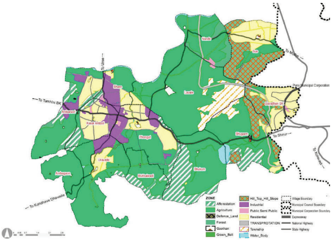
Pirangut Growth Centre includes part of RP 1997 Sectors such as Sector PMR, C, D and P, which is around Pirangut-Bhare-Uravade and the surrounding area. A self-sufficient township was proposed for the projected population of 0.75 lakh. It was located in Pirangut, Kasar Amboliand Uravade, with Pune-Paud Road passing through the township.
In terms of transport planning, the Regional Plan proposed to widen the Pune-Paud Road to 60 m width with 12 m wide service roads on either side. It also proposed 36 m wide northern side diversion and link roads. Similarly, 30m and 24m wide major roads were proposed circumventing the industrial and residential areas. Further, it proposed the widening of the road along the village boundary of Pirangut, connecting Paud road to Mutha road, to 30 m.
Figure 25.2: RP 1997 Zoning Map
| Land use category | Area (ha) | Percentage of Devel-oped Area | Percentage of Total Area |
|---|---|---|---|
| Residential | 1884.3 | 64% | 17% |
| Industrial | 495.03 | 17% | 5% |
| Public - Semi Public | 44.01 | 1% | 0% |
| Transport | 521.8 | 18% | 5% |
| Total Developable Area | 2945.14 | 100% | 27% |
| Agriculture | 5874.75 | 54% | |
| Forest | 174.34 | 2% | |
| Hilltop Hill slope | 773.51 | 7% | |
| Afforestation | 990.14 | 9% | |
| Green Belt | 27.88 | 0% | |
| Water body | 187.088 | 2% | |
| Total Non Developable Area | 8027.71 | 73% | |
| Total | 10972.8 | 100% |
Existing Land Use
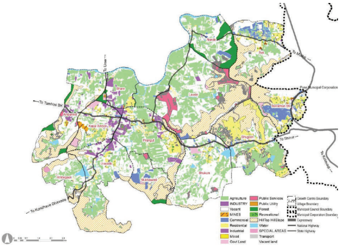
Pirangut Growth Centre has rapidly developed along the NH-753F due to proximity with PMC and established premier university campuses and institutions. However, most of the Growth Centre land is under agricultural use (30%) followed by a hill top hill slope (20%) which conveys the environmental sensitivity of the Growth Centre.
The total area of the Growth Centre is 10973.95 Ha. 17.58% of the area is developed, with residential (6% of the total Growth Centre area) usage dominating the land use, followed by PSP use (4% of the total Growth Centre area). Residential use covers major residential township/housing schemes such as Forest Trails, Highlands Apartments, SKY Star, Oxford Township, Kalyani Township, Kaleidoscope and existing Gaothan areas. Residential use is clustered at Sus, Bavdhan, Bhugaon, Bhukum, Pirangut, Bhare, and KasarAmboli. It represents high real estate demand triggered by the expansion of PMC.
Public semi-public use covers renowned private institutions such as Symbiosis International University, Indus International School Pune, International School of Business and Media, Vidya Valley School, Sri Chaitanya College Saraswathi Bhavan, Foundation for Liberal And Management Education and Chellaram Diabetes Institute. Industrial developments are present at Ambarwet, KasarAmboli, Uravade, and Pirangut as a result of the implementation of the industrial zone proposed in RP 1997.
Figure 25.3: Existing Land Use Map
Chapter 25: Growth Centre: Pirangut
| Land use category | Area (ha) | Proportion of Total Developed Area (%) | Proportion of Total Area (%) |
|---|---|---|---|
| Residential | 694 | 36% | 6.32% |
| Commercial | 309.2 | 16% | 2.82% |
| Industrial | 240 | 12% | 2.19% |
| Public Semi Public | 434 | 22% | 3.95% |
| Transport | 247.19 | 13% | 2.25% |
| Public Utilities | 4.75 | 0% | 0.04% |
| Total Developed Area | 1929.14 | 100% | 17.58% |
| Agriculture | 2942 | 26.81% | |
| Vacant Land | 3274 | 29.83% | |
| Forest | 211.18 | 1.92% | |
| Hilltop Hill Slope | 2240 | 20.41% | |
| Special Areas | 22.84 | 0.21% | |
| Recreational | 73.89 | 0.67% | |
| Water Body | 280.90 | 2.56% | |
| Total Non-Developed Area | 9044.81 | 82.42% | |
| Total | 10973.95 | 100.00% |
Key Challenges
-
Inhabitation of hilltops-hillslopes and afforestration areas due to growing real estate development.
-
Pollution of Mula River due to adjacent industrial growth.
-
Absence of sewerage, stormwater drainage and solid waste management systems
-
Compared to increasing development demand/trend, supporting road and transport infrastructure is inadequate.
-
Existing highways such as SH-130 and SH-115 are operating at/over capacity.