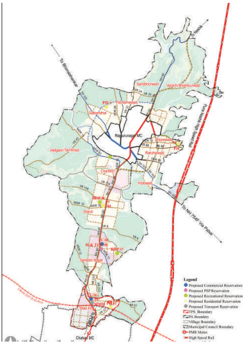
Khed Rajgurunagar Growth Centre is envisioned as a Commuter Town leveraging upon following assets;
-
Land availability and a potential for expansion required around Rajgurunagar and Chakan Municipal Councils.
-
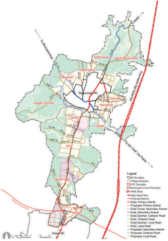
Good accessibility by Pune- Nashik Highway and proposed Metro line from PMC and PCMC as per CTTS study.
-
Good accessibility by proposed Pune-Nashik High Speed Rail and Crescent railway, to the industrial clusters of Talegaon, Chakan and Shikrapur as well as PMC.
Socio - economic Projections
Based on the URGD method, projected population for the Growth Center would be as below:
| Village | 2011 | 2018 | 2031 | 2041 |
|---|---|---|---|---|
| Chandoli | 3363 | 4,934 | 7,071 | 8,770 |
| Dhorewadi | 797 | 1,008 | 1,108 | 1,124 |
| Holewadi | 2576 | 4,053 | 5,707 | 6,905 |
| Pacharnewadi | 777 | 834 | 898 | 940 |
| Rakshewadi | 5113 | 6,618 | 10,497 | 14,501 |
| Sandbhorwadi | 1587 | 1,877 | 2,078 | 2,163 |
| SantoshNagar( N.V). | 1578 | 2,123 | 2,985 | 3,583 |
| Satkarsthal | 3450 | 9,136 | 13,677 | 16,161 |
| Shiroli | 5255 | 7,007 | 9,886 | 12,400 |
| VadgaonTarfKhed | 2331 | 2,532 | 2,772 | 2,935 |
| VarchiBhamburwadi | 1915 | 2,024 | 2,123 | 2,189 |
| WakiKh. | 2509 | 3,375 | 5,458 | 7,515 |
| Total | 31251 | 45520 | 64260 | 79186 |
The projected resident workforce based on the projected population through the URGD method is 35,783. Considering the proposed economic activities of all the growth centres, employment distribution was proposed based on the envisaged sectoral split for that Growth Centres. Accordingly, the employment to be generated for the Growth Centre for the year 2041 is estimated to be 38,950. The proposed residential density is about 125 PPH (12,500 persons/sq km).
For the planning of sustainable and self-sufficient infrastructure and amenities distribution with proposed population density, the Growth Centre is considered as a single sector.
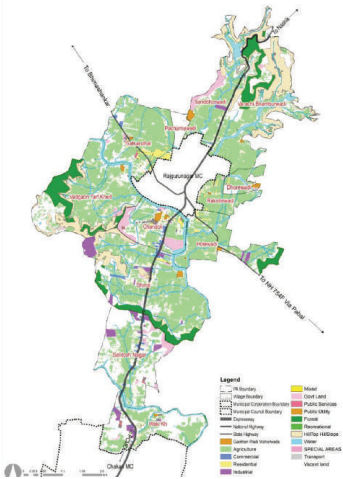
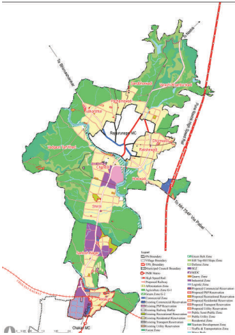
Proposed zoning would determine efficient use of land for the next 20 years. Proposed zoning plan is an output of existing landuse and physical conditions analysis; understanding of most pressing issues of the Growth Center; local knowledge of the place; and deployment of five planning goals and allied physical planning strategies.
Summary of proposed zoning area statement is presented below:
Chapter 29: Growth Centre: Khed Rajgurunagar
Figure 29.4: Proposed zoning map
| Land use category Area (ha) | Proporti oped Are | on of Total Devel- Proporti a (%) (%) | on of Total Area |
|---|---|---|---|
| Residential | 1075.33 | 59.61% | 21.75% |
| Gaothan | 12.52 | 0.69% | 0.25% |
| Commercial | 36.12 | 2.00% | 0.73% |
| Industrial | 190.55 | 10.56% | 3.85% |
| Logistic | 65.20 | 3.61% | 1.32% |
| PublicsemiPublic | 67.63 | 3.75% | 1.37% |
| Transport | 349.39 | 19.37% | 7.07% |
| PublicUtilities | 7.34 | 0.41% | 0.15% |
| TotalDevelopableArea | 1804.07 | 100% | 36.49% |
| Agriculture (G1) | 2018.08 | 40.82% | |
| Forest | 410.23 | 8.30% | |
| Afforestation | 26.78 | 0.54% | |
| HilltopHillslope | 345.37 | 6.99% | |
| GreenBelt | 71.58 | 1.45% |
| Recreational | 41.30 | 0.84% |
|---|---|---|
| WaterBody | 226.31 | 4.58% |
| TotalNon-DevelopableArea | 3139.66 | 63.51% |
| Total | 4943.73 | 100% |
Translating Goals into the Plan
Proposed zoning ensures that the sectoral development goals are clearly conveyed through it. For brevity, proposed sectoral goals and their corresponding physical planning strategies are mentioned in figure below:
| Goals | Development Sector addressed | Physical planning strategies |
|---|---|---|
| Prudent | Employmentandhousing | Work -LiveHubs |
| Convenient | Roadsandmasstransport | MovementLattice |
| Resilient | Environmentprotection | Green -Blueconnectors |
| Efficient | Infrastructureandutilities | Decentralisedresourcemanagement |
| Self -sufficient | Socialfacilities | WalkableNeighbourhoods |
Following sections elaborate translation of sectoral development goals into the zoning plan.
Prudent: Work-Live Hubs
‘Prudent’ goal would be addressed by Work-live concept that implies working closer to homes. As explained in proposed vision framework, in context of metropolitan regions it is assumed that maximum 30% of the resident workforce would be employed within a suburb/ town where they reside.
For Khed Rajgurunagar Growth Center, work-live concept is applied by
-
Due to Chakan MIDC (approx. 11 Km. away) and small scale industries at Waki - Khurd ,surrounding area is developed upto 10% approximately.
-
Designating residential zones within 500 m around industrial, Regional Centre and commercial zones to minimise work related trips for at least 30% of the resident workforce Due to strong connectivity by NH 60, residential nodes are proposed along NH 60 and surrounding of Rajgurunagar municipal council at Rakshewadi, Satkarsthal, VadgaonTarf Khed, Pacharnewadi, Dhorewadi, Chandoli, Shiroli, Santosh Nagar and Waki Khurd.
-
An additional Industrial zone is proposed along NH 60 at village Chandoli, Santoshnagar and Waki Khurd, Southern part of the Growth Centre is expanded as per the Existing land use .The industrial nodes are well connected through proposed Pune Nashik Highway, High-speed railway, proposed crescent railway line, and proposed PMR metro line.
-
The Residential zone is in proximity to NH 60 , proposed Metro Depot and Railway station.
The proposed employment for planning area for 2041 is 38,950 employees which is 49.18% of the projected population. The proposed net residential density is about 125 ppl/ ha (12500p/sq km) in order to promote the Work-Live Hub concept.
Two town centres are proposed. One is at Santoshnagar and and another one is at Waki Khurd, invicinity to proposed Cresent railway station.