Khadakwalsa is attributed as ‘Commuter Town’ and has an independent character. The objective behind assigning this role to Khadakwasla is because of its capacity for accommodating future residential population of adjacent Pune City. This area is surrounded by PMC which has employment opportunity, hence work to live relationship can be achieved by promoting residential development. Hilly area and forest are abundant in growth centre. Existance of river and water bodies make growth centre self-sufficient in itself in all natural aspect. PMRDA ring road and NH 48 act as mass transport system to growth centre.
Promote residential development to maintain work-live relation. propose the Town level and neighbourhood level amenities in such way that it will make the growth centre self sufficient and maintain the character of growth centre. i.e ‘Commuter Town’
Promoting Planned Development through TP Scheme to balance over densification.
Enhance the commercial activities and Public semi public area proposed as per regional plan and promote industrial activities for local employment generation.
Develop a grid network of secondary and tertiary roads for a smooth movement within the Growth Centre
Promote PMRDA ring road and NH 48 as Mass transportation system.
Utilization of available government land parcel for upliftment of development.
Promote self-sufficient town by proposing required amenities and utilities for the projected population
Conservation of green cover i.e Forest and Hill top hill slope (HTHS)
Develop Transport infrastructure facilities along major transport corridor.
Establish last mile connectivity to unaccessible villages.
Establish green and blue network by designating green belts along blue line of Mutha river, and existing stream with green avenue.
Promote tourist activities around Khadakwasla Dam.
Integrated Town Planning Scheme in Khadakwasale, Kirkitawadi, Nandoshi and Sanasnagar village.
Education Complex at Khadakwasale (28.48Ha).
Town Centre (CBD) along PMRDA ring road.
Sport Complex (2.19 ha) at Khadakwasle and Nimbalkarwadi
Truck Terminal (3.09 ha) at Mangewadi along PMRDA ring road.
Multimodal hub at Bhilarewadi.
Tourism Development in Khadakwasale and Kondhave Dhavade.
24.2Existing Situation Anlysis
Khadakwasla comes under Haveli Taluka and comprises of 13 villages, namely, Kondve Dhavde, Kopare, Nanded, Khadakwasla, Kirkitwadi, Nandoshi, Sanas Nagar, Kolawadi, Jambhulwadi, Bhilarewadi, Nimbalkarwadi, Mangewadi, Narhe. The total planning area is about 59.11 Sq. km. According to census 2011 population of planning area is 77,258. Key strength of Khadakwasla Growth Centre is its location, adjoining to PMC and well connectivity with PMC through NH and SH.
Location &Connectivity
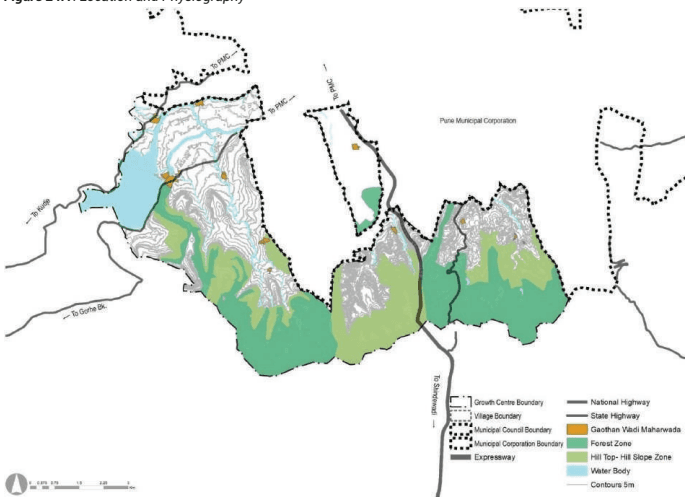
Khadakwasla is located on the southern side of PMC next to the Defense land within Haveli Taluka. It is surrounded by Khed Shivapur on the south-east side, Haveli Rural on the south, west and southern west side, PMC on the East. The south-western edge is flanked by the Western Ghats region. Entire area is situated on undulating surface. The north-western front is adorned by the Khadakwasla dam area. Only towards the PMC side, the gradient of the slopes allow development, Due to hilly nature of the planning area. Khadakwalsa growth centre connected with PMC by SH 133 and SH 115. SH 126 connect PMC at Katraj junction. NH 48 connect growth centre with proposed industrial development in Khed-Shivapur growth centre.
Mutha River edges the northern part of Growth Centre, with a stream aligning the SH 115 flow towards the PMC. Khadakwasla Dam is located nortern west of planning area near Khadakwalsa Village. Canal starting from south of Khadakwasla dam flows toward Swargate in PMC. Most of the area on southern side of growth centre is under HTHS and Forest.
Figure 24.1: Location and Physiography
Chapter 24 Growth Centre: Khadakwasla
Regional Plan (1997) Analysis
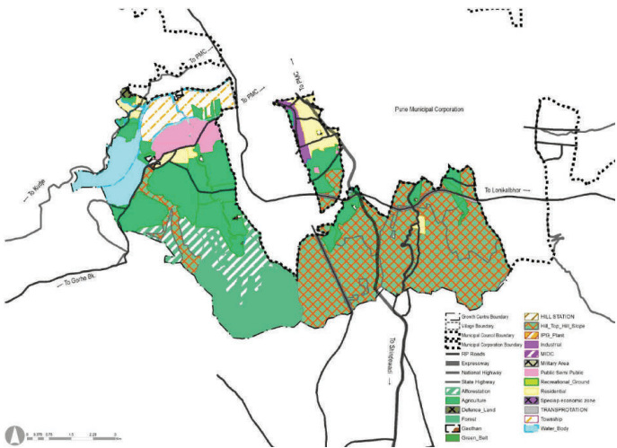
This growth centre forms part of sector E and sector F. Area along Sinhagad road was proposed as Residential zone in village Kondhave-Dhawade, Kirkatwadi. Narhe village is now surrounded by PMC, had residential zone in RP. Nanded city township cover most of the area of Nanded village. In RP 1997, Industrial zone was proposed in Narhe village. Green belt of 30 M was demarcated for river for Mutha river. 90 M wide road was proposed from Bhor taluka which is modified as 110M PMRDA ring road. Sinhagad road was proposed 36M with suitable diversion alignment from development. 30M wide road link was proposed to connect NH 48 and SH 133. CWPRS – Central water power research Station was important proposal in growth centre as per RP. The rest of the area not earmarked for specific zones is marked in Agricultural/ No development zones.
Total developable land as per RP 1997 is 971 Ha. out of which 540 Ha was proposed for residential zone. 2.98% of total growth centre was proposed for Transportation. Hilltop hill slope cover 2315Ha area in Khadakwasala growth centre. 56 Ha of industrial area proposed in Narhe. 4940 Ha of land is non developable which share 83.57 %.
Figure 24.2: RP 1997 Zoning map
Table 24.1RP 1997 Zoning area statement
Land use category
Area (ha)
Percentage of Total Developable Area
Percentage of Total Area
Residential
540.56
56%
9.14%
Industrial
56.79
6%
0.96%
Public semi Public
197.5
20%
3.34%
Transport
176.38
18%
2.98%
Total Developable Area
971.23
100%
16.43%
Agriculture
1169.35
19.78%
Forest
607.77
10.28%
Hilltop Hillslope
2315.19
39.17%
Defence
14.08
0.24%
Afforestation
448.12
7.58%
Green Belt
1.44
0.02%
Water Body
384.06
6.50%
Total Non-Developable Area
4940.01
83.57%
Total
5911.24
100%
Existing Land Use
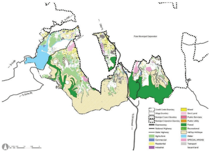
Residential area component in Narhe is comparatively very high due to concentrated residential development spread across. Nanded village also has very high residential development due to integrated township and residential layout. Residential nodal development is seen in Narhe, Nanded and Kirkitwadi. Industrial development occurred at Narhe village in some extent.
HTHS occupying 1913 ha of land, almost 34 % of the land of total planning area. Followed by agriculture land, which is 11.20% of the total planning area.A good amount of vacant land, 20% of total area is found in Bhilarewadi, Narhe and Kirkitwadi providing development opportunity.
Most of the forest land found in Bhilarewadi and Nandoshi, covering total area of 946 ha. which is 17% of total planning area. Nimbalkarwadi, Kolavadi, Sanas nagar and Khadakwasle has very high HTHS, covering total area of 1913 Ha which is 34% of total planning area. Total water body area within planning area is 392 Ha due to presence of Khadakwasle dam, Mutha river and water canal.Khadakwasla Growth Centre enjoys great locational advantage due to its proximity to adjoining PMC and presence of accessibility through Mumbai-Banglore National highway, one of the busiest transport route in PMR.
Figure 24.3: Existing land use map
Chapter 24 Growth Centre: Khadakwasla
Table 20.2Existing land use area statement
Land use category
Area (ha)
Percentage of Total Developable Area
Percentage of Total Area
Residential
267.24
45%
4.69%
Commercial
36.08
6%
0.63%
Industrial
29.57
5%
0.52%
Public semi Public
132.85
23%
2.33%
Transport
119.46
20%
2.10%
Public Utilities
2.29
0%
0.04%
Total Developable Area
587.49
100%
10.31%
Agriculture
638.32
11.20%
Vacant land
1152.17
20.22%
Forest
946.77
16.62%
Hilltop Hillslope
1913.41
33.59%
Special areas
54.26
0.95%
Recreational
12.3
0.22%
Water Body
392.2
6.88%
Total Non-Developable Area
5109.43
89.69%
Total
5696.92
100.00%
Issues in Existing Scenario
Residential Zone in some area is densely developed as per proposed RP zoning. This creat congestion in these areas.
Sporadic development is observed surrounding gaothan, where no RP zone was proposed. Major share of illegal construction is present at such location.
Major unauthorized development is observed along transport corridors i.e NH-48.
Less availability of government land for infrastructure development.
Chapter 24
24.4 Proposed Reservation Statement, Costing and Phasing
Table 24.10Proposed Reservation Statement
No
Purpose of Reservation
Planning Standard
Planning Standard
Total Re-quirement
Total Re-quirement
Existing/ Available
Existing/ Available
Proposed Reserva-tions
Proposed Reserva-tions
Total Reserva-tions
Total Reserva-tions
Area (Ha.)
Min unit re-quired
No of sites
Area in Ha
No of sites
Area in Ha
No of sites
Area in Ha
No of sites
Area in Ha
1
Primary School (I-V)*
0.4 ha including playground.
1/5000 ppl,1/500 students
47
18.6
51
10.39
4
1.97
55
12.36
2
Secondary School (VI-XII)*
1 Ha. / site (0.6 ha for play ground and 0.4 ha for building )
1/1000 students 1/10000 population
23
23.25
25
22.23
3
2.83
28
25.06
3
Health Centre
0.08 - 0.12 Ha
1HC / 15,000 population
16
1.86
7
0.86
14
3.29
21
4.15
4
Community Hall
0.2 ha/ site
1/15000 ppl
16
3.10
1
0.20
10
2.04
11
2.24
5
Garden
1 Ha
1/15000 ppl
16
15.50
1
1.02
26.00
25.82
27.00
26.84
6
Playground
1.5
1/15000 ppl
16
23.25
1
0.54
25
27.5
26
28.04
7
Shopping Centre/ Market
0.3-0.45
1/15000 ppl
16
4.65
2
2.54
10
4.53
12
7.07
Town Level
Town Level
Town Level
Town Level
Town Level
Town Level
Town Level
Town Level
Town Level
Town Level
Town Level
Town Level
1
College
5 Ha
1000 - 1500 students
2
10
7
123.20
0
0
7
123.20
1
College
5 Ha
1/1.25 lakh population
2
Hospital/ Trauma Care Centre
Cat A = Area- 3.70 Ha
1/1 Lac
2
2
1
1.20
1
1.04
2
2.24
2
Hospital/ Trauma Care Centre
200 beds, Cat B = Area =1 Ha., 80 beds
3
Public Housing
-
0
0
5
9.38
5
9.38
4
Housing for Dishouse
0
0
0
0
0
0
6
Social Welfare Centre
0.6-1 Ha.
1/1 Lac
2
2
0
0
2
1.68
2
1.68
7
Town Park
3-5
1/1 Lac
2
6
0
0
2
7.9
2
7.9
8
Sports Complex
3-5
1/1 Lac
2
6
0
0
2
3.06
2
3.06
9
Multipurpose Ground
As per land availability
0
0
3
3.10
3.00
3.10
10
Fire Brigade Station
0.4
As per requirement of Fire depart-ment of PMRDA. 1 Fire station / growth centre
2
0.8
0
0
4
1.13
4
1.13
No
Purpose of Reservation
Planning Standard
Planning Standard
Total Re-quirement
Total Re-quirement
Existing/Available
Existing/Available
Proposed Reserva-tions
Proposed Reserva-tions
Total Reserva-tions
Total Reserva-tions
Area (Ha.)
Min unit re-quired
No of sites
Area in Ha
No of sites
Area in Ha
No of sites
Area in Ha
No of sites
Area in Ha
11
Burial ground
4 Ha.
1 site/ 5 lakh,
0
0
1
0.4
1
1.23
2
1.63
12
Cremation ground
2.5 Ha
1 site/ 5 lakh,
0
0
13
2.96
0
0
13
2.96
13
Solid Waste Management Site
5 Ha . (As per land availabili-ty)
1 site per growth centre
1
5
0
0
2
10.18
2
10.18
14
Sewerage treatment plant
80% of water supply may be expected to reach the sewers
Land area requirement is as per URDPFI i.e. For activated Sludge Process(ASP)-0.15Ha/MLD
3.14
0
0
8
5.01
8
5.01
15
Water works (Water treat-ment Plant, tanks & pipes)
Land area requirement is as per URDPFI i.e.Land area requirement is as per URDPFI i.e. 1) 5MLD- 0.10 Ha 2) 10MLD-0.19Ha 3) 50MLD- 0.93 Ha 4) 100MLD-1.87Ha 5) 200MLD-3.73Ha 6) 500MLD-9.34Ha
Water require-ment of PMR is 72 lpcd as per Report 'Integrated Master Plan Of Water Supply, Sewerage, Storm Water and Solid Waste Man-agement in the PMR'. It is distributed to each Growth center.
1.12
0
0
2
1.4
2
1.4
16
Effluent Treatment Plant
As per Requirement
1
0.09
1
0.58
1
0.58
17
Government Purpose
0
0
4
2.55
4
2.55
18
Police Station
As per Government Requirement
0
0
7
3.03
7
3.03
19
Bus Depot
As per Government Authority requirement
1
2.44
1
0.48
2
2.92
20
Electric Sub station
As per Government Requirement
0
0
1
0.2
1
0.2
21
Government Purpose
As per Government Requirement
0
0
4
2.55
4
2.55
Chapter 23: Growth Centre: Loni Kalbhor
No
Purpose of Reservation
Planning Standard
Total Re-quirement
Existing/ Available
Proposed Reserva-tions
Total Reserva-tions
Area (Ha.)
Min unit re-quired
No of sites
Area in Ha
No of sites
Area in Ha
No of sites
Area in Ha
No of sites
Area in Ha
22
Government Office
As per Government Requirement
0
0
3
0.61
3
0.61
23
Post Office
As per Government Requirement
0
0
2
0.13
2
0.13
24
Parking
0
0
5
1.81
5
1.81
25
Trauma Care Centre
0
0
1
0.46
1
0.46
Regional level
1
Town Cwnter
14 Ha. (As per concept plan)
0
0
1
3.72
1
3.72
2
Business Center
0
0
1
2.11
1
2.11
3
Multimodal Hub
0
0
1
5.02
1
5.02
4
Railway Station
2
2.16
3
35.67
5
37.83
5
Truck Terminal
0
0
1
2.76
1
2.76
6
Metro Depot/ Car shed
0
0
1
12.08
1
12.08
7
Renewable Energy Park
0
0
1
19.25
1
19.25
Table 23.11Cost and Acquisition Statement for Proposed Reservations