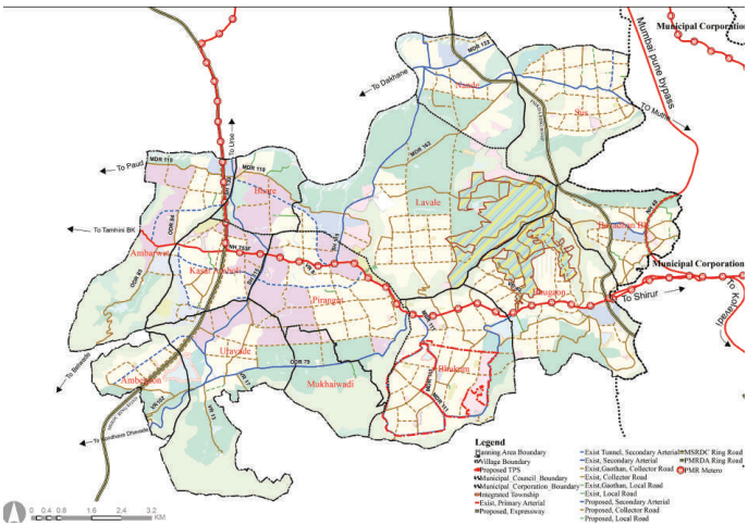
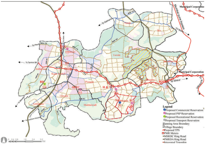
Pirangut is envisioned to be developed into a “Knowledge Hub”. This strategy aims to leverage the existing educational ecosystem in the area with the presence of premier university campuses and growing demand from educational institutes for expansion or relocation of their campuses from municipal corporation areas. Further, the strategy aims to promote the establishment of campuses of foreign universities and set up an integrated design university to support emerging industries such as AI and Robotics. This area possesses a scenic natural setting created by hills and rivers and enjoys good accessibility through Mumbai-Bangalore National Highway and Pune-Kolad National Highway, proposed Ring Roads and Metro Line.
Key indicators
Growth Centre Area
10974 HA
Population
61,111(2011); 325,594 (2031); 454,553 (2041)
Population excluding ITP/TPS
61,111(2011); 2,45,699 (2031); 294,763(2041)
Net Population Density
125 PPH
Resident Workforce
2,14,442 (2041)
Employment
97,652 (2041)
Households
132,197 (2041)
Proposed Zones
Residential (3415.09 Ha), Industrial (820.31 Ha), Commercial (179.43 Ha) Public Semi Public (315.31Ha)
Key Planning Strategies
Promote the development of Pirangut as a “University Town” by allocating PSP zoning to encourage the setting up of educational institutions/campuses of international repute and R&D centres
Consolidate industrial zoning around existing industrial activities and industrial zoning proposed in RP 1997 to tap into higher potential due to direct connectivity to Dighi port and upgraded Paud-Mulshi National Highway.
Open up residential zoning around proposed industrial and PSP zoning, within 500m to promote work live concept and serve these by the proposed Hinjawadi-Pirangut Metro Line.
Develop a grid network of secondary and tertiary roads for a smooth movement within the Growth Centre
Promote self-sufficient town by proposing required amenities and utilities for the projected population
Promote logistic and warehousing activities by consolidating cluster development leveraging upon existing high demand along the NH-753F
Protect all the natural streams in the Growth Centre.
Establish green-blue links by designating green belts along Mula and Ramnadi Rivers and protecting ridge/ steep slopes (>1:5), and connecting these by avenues
Education complex at Bhukum.
Industrial Research and Training Centre at Mukhaiwadi.
Biodiversity Park (Nature Interpretation Park) at Kasar Amboli.
Hinjewadi-Pirangut Metro line along the NH-753 F with a depot at Pirangut.
One Multimodal hub (1.55 ha) at the junction of NH-753F and PMRDA Ring Road.
Trauma Care Centre and Fire Station at Bhare also Hospital and Trauma Care Centre at Bhukum.
Town Centre at Bhukum.
Tourism development within green belt around Manas Lake.
25.3Proposed Role and Strategies
Pirangut is positioned as a ‘Knowledge Hub’, and the key reasons for this are as follow:
Leverage the existing educational ecosystem in the area with the presence of premier university campuses and growing demand from educational institutes for expansion or relocation of their campuses from municipal corporation areas.
Need for an Integrated Design University to support emerging industries such as A l r Robotics, Green Mobility, Defence and Life sciences industriesGood regional accessibility through Mumbai-Bangalore National Highway and Pune-Kolad National Highway
established industrial cluster and proposed industrial zone as per RP 1997
Table 25.3Population Projections
Village
2011
2018
2031
2041
Ambarwet
2,472
4,546
5,685
5,970
Ambegaon
820
1,409
1,691
1,734
Bavadhan BK
10,438
29,319
40,023
42,689
Bhare
1,479
7,519
10,347
10,602
Bhugaon
5,949
22,821
60,926
93,025
Bhukum
2,859
6,544
20,848
33,613
KasarAmboli
5,397
15,897
31,040
45,296
Lavale
6,732
9,049
55,538
1,02,023
Mukaiwadi
989
1,504
2,430
3,321
Nande
1,622
2,208
2,654
2,869
Pirangut
14,174
35,255
59,018
77,247
Sus
4,862
18,906
25,770
26,664
Uravade
3,318
7,874
9,625
9,500
Total
61,111
1,62,853
3,25,594
4,54,553
The projected resident workforce based on the projected population through the URGD method is 2,14,442. Considering the proposed economic activities of all the growth centres, employment distribution was proposed based on the envisaged sectoral split for that Growth Centres. Accordingly, the employment to be generated for the Growth Centre for the year 2041 is estimated to be 97,652. The proposed residential density is about 125 PPH (12,500 persons/sq km).
Proposed Planning Divisions
For the planning of public facilities distribution, Pirangut Growth Center is divided into three sectors.
Sector one includes Bavdhan Bk, Bhugaon and Sus, Sector two include Lavale, Nande & Pirangut and Sector three contains Ambarwet, Ambegaon, Bhare, Bhukum, Kasar Amboli, Mukaiwadi and Uravade villages.
The boundaries of this planning division are shown on the Proposed Zoning Map. The projected sector-wise population statement is in Table 25.3.
Table 25.4Projected Population - Sectors
Sector
2011
2018
2031
2041
Sector 1
21,249
71,046
1,26,719
1,62,378
Sector 2
22,528
46,513
1,17,210
1,82,138
Sector 3
17,334
45,294
81665
1,10,037
Total
61,111
1,62,853
3,25,594
4,54,553
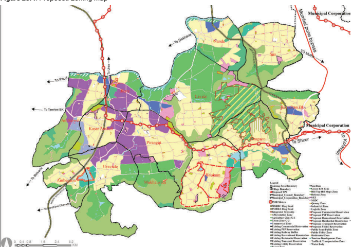
The proposed zoning would guide and determine the optimal and efficient land use for the next 20 years. The proposed zoning plan is an output of existing land use and physical conditions analysis, understanding of most pressing issues of the Growth Center, local knowledge of the place and deployment of five planning goals and allied physical planning strategies. The proposed zoning area statement is presented in Table 25.5.
Chapter 25: Growth Centre: Pirangut
Figure 25.4: Proposed Zoning Map
Table 25.5Proposed Zoning Area Statement
Land use category
Area (ha)
Proportion of Total Developed Area (%)
Proportion of Total Area (%)
Residential
3415.09
58.96%
31.16%
Gaothan
55.96
0.97%
0.51%
Commercial
179.43
3.10%
1.64%
Industrial
829.31
14.32%
7.57%
Logistic Zone
86.53
1.49%
0.79%
Public and semi public
315.31
5.44%
2.88%
Public Utility
30.58
0.53%
0.28%
Transportation
880.23
15.20%
8.03%
Total Developed Area
5792.44
100.00%
52.85%
Agriculture
2265.50
20.67%
Afforestation
46.34
0.42%
Water bodies
278.11
2.54%
Hilltop Hill Slope
2013.19
18.37%
Recreational
133.60
1.22%
Forest
231.32
2.11%
Tourism Development Zone
103.75
0.95%
Green Belt
95.93
0.88%
Total Un-developed Area
5167.75
47.15%
Total Area
10960.19
100.00%
Translating Goals into the Plan
Proposed zoning ensures that the sectoral development goals are clearly conveyed through it. Proposed sectoral goals and their corresponding physical planning strategies are mentioned in Table 25.5.
Table 25.6Goals and Physical Planning Strategies
Goals
Development Sector Addressed
Physical Planning Strategies
Prudent
Employment and housing
Work- Live Hubs
Convenient
Roads and mass transport
Movement Lattice
Resilient
Environment protection
Green- Blue connectors
Efficient
Infrastructure and utilities
Decentralized resource management
Self- sufficient
Social facilities
Walk able Neighbourhoods
For Pirangut Growth Center, the Work-Live concept is applied by:
Pirangut Growth Centre is divided into three nodes - first is industrial on the west side along the SH-115 and SH-130, which includes Pirangut, Kasar Amboli and Bhare. The second is residential usage on the east side of the planning area, covering Bavdhan Bk., Sus and Bhugaon. The third is the Public Semi-Public (educational) area in the middle of the planning area in Lavale village and south of planning area at Bhukum village
Designating residential zones within 500 m around industrial, logistics and commercial zones to minimize work-related trips for at least 30% of the resident workforce.
Allocating industrial, logistics, and commercial zones along the proposed mass transit corridors to reduce travel time for workforce commuting from other Growth Centers.
Land requirement for the residential zone is estimated based on a net residential density of 125 PPH. Further, 45% add-on is considered to account for amenity (15%), open spaces (10%) and roads (20%). Accordingly, the total gross area required for the projected GC population of 4,54,553 by 2041 is estimated to be 4006 Ha..
The total population of ITP in the Growth Centre is 1,59,790, while the projected population for the rest of the Growth Centre is 2,94,763. Accordingly, the total gross area required for the total projected GC population of 4,54,553 is estimated to be 4006 Ha.
Considering the projected population, net residential density, proposed role and existing growth trends within the Growth Centre 3415.09 Ha. of gross residential zone is proposed.
As per the Work Live hub concept, consolidated residential zoning is proposed in the Growth Centre. Bottom up approach is adopted to allocate residential zone. Existing gaothans such as Bhukum, Pirangut, Kasar Amboli, Uravade, Lavale, and Nande are considered as social nucleus and residential real estate hot spots. To drive their
Chapter 25: Growth Centre: Pirangut
future growth, a residential zone is allocated at these villages. As mentioned earlier, development potential is almost saturated in fringe villages of PMC such as Bhugaon, Bavdhan, and Sus where only infill residential development is envisaged through zoning.
Out of the total proposed industrial zone of 186.6 sq.km, 9.3 sq.km of industrial development is envisaged at Pirangut growth centre, based on 50 workers/Ha.
Pirangut Growth Centres would enhance the future growth of the Study Area’s industrial sector with a new employment generation estimated to be 97,652. Considering the existing industrial development scenario, strategic infrastructure proposals within the Growth Centre and the planning intent of RP 1997, industrial zone over an area of 829.31 ha. is proposed.. It is arrived at by considering worker density of 50 workers/ha and increasing it by 30% to account for roads (15%), open spaces (10%) and amenity (5%).
The industrial zone as per ELU was 240 Ha while 495 Ha were proposed in RP 1997. Thus considering the existing scenario of industrial development, the strategic infrastructure proposals and planning intent of Regional Plan, 829.31 ha of industrial zone is proposed. The planning intent is to consolidate industrial zone around existing industrial development and industrial zone proposed in RP 1997 at Ambarwet, Kasar Amboli, and Pirangut.
25.2Existing Situation Analysis
Pirangut Growth Center is a part of Mulshi taluka comprising 13 villages: Bavdhan (BK), Sus, Bhugaon, Lavale, Nande, Pirangut, Kasar Amboli, Mukaiwadi, Uravade, Bhare, Ambarwet, Ambegaon and Bhukum. Its total area is 109.73 sq km. According to the Census 2011, the population of Pirangut Growth Centre was 61,111 and the estimated population for 2018 is 1,62,852 with 37,344 employment.
The Growth Centre has several premier university campuses. Further, it enjoys good regional connectivity through Mumbai-Bangalore National Highway (NH-48) and Pune - Kolad National Highway (NH-753F)
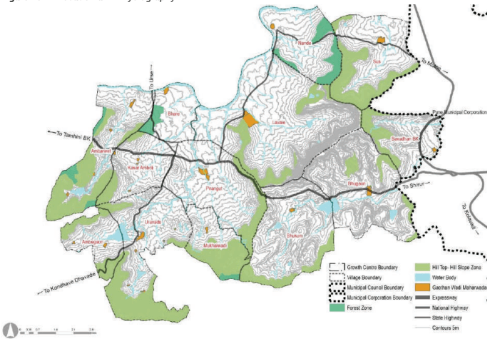
Pirangut Growth centre is located on the west side of PMR along the Pune-Kolad National Highway (NH-753F). It shares its eastern boundary with Pune Municipal Corporation. Mula River abuts it on the north, National Defence Academy on the south and hilly rural area on the south and west sides. Hinjawadi growth centre located on northern side of Pirangut growth centre, sharing boundary with Nande and Sus village of Pirangut growth centre.
Mumbai-Bangalore National Highway (NH-48) passes through the eastern part of the Growth Centre. Pirangut GC future connectivity is likely to be strengthened since it is sandwiched between the proposed Ring Roads by PMRDA and MSRDC. State Highway (SH-115) passes longitudinally through the Growth Centre. Further, SH-130 connects it with the Hinjawadi Growth Centre.
Natural
Features
In terms of physiography, Pirangut GC is a combination of undulating terrain and gently sloping plains. A ridgeline divides the Growth Centre into eastern and western parts. The western part has tributaries that drain into the Mula River, whereas the eastern part drains into the Ram River. Marnewadi dam and Manaslake are notable water bodies situated in the Growth Centre. Degradation of the Mula River as a result of a lack of proper waste management systems is another concern.
Figure 25.1: Location and Physiography
Chapter 25: Growth Centre: Pirangut
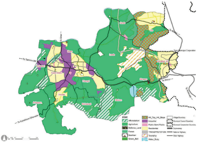
Pirangut Growth Centre includes part of RP 1997 Sectors such as Sector PMR, C, D and P, which is around Pirangut-Bhare-Uravade and the surrounding area. A self-sufficient township was proposed for the projected population of 0.75 lakh. It was located in Pirangut, Kasar Amboliand Uravade, with Pune-Paud Road passing through the township.
In terms of transport planning, the Regional Plan proposed to widen the Pune-Paud Road to 60 m width with 12 m wide service roads on either side. It also proposed 36 m wide northern side diversion and link roads. Similarly, 30m and 24m wide major roads were proposed circumventing the industrial and residential areas. Further, it proposed the widening of the road along the village boundary of Pirangut, connecting Paud road to Mutha road, to 30 m.
Figure 25.2: RP 1997 Zoning Map
Table 25.1RP area Statement
Land use category
Area (ha)
Percentage of Devel-oped Area
Percentage of Total Area
Residential
1884.3
64%
17%
Industrial
495.03
17%
5%
Public - Semi Public
44.01
1%
0%
Transport
521.8
18%
5%
Total Developable Area
2945.14
100%
27%
Agriculture
5874.75
54%
Forest
174.34
2%
Hilltop Hill slope
773.51
7%
Afforestation
990.14
9%
Green Belt
27.88
0%
Water body
187.088
2%
Total Non Developable Area
8027.71
73%
Total
10972.8
100%
Existing Land Use
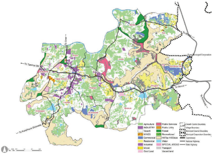
Pirangut Growth Centre has rapidly developed along the NH-753F due to proximity with PMC and established premier university campuses and institutions. However, most of the Growth Centre land is under agricultural use (30%) followed by a hill top hill slope (20%) which conveys the environmental sensitivity of the Growth Centre.
The total area of the Growth Centre is 10973.95 Ha. 17.58% of the area is developed, with residential (6% of the total Growth Centre area) usage dominating the land use, followed by PSP use (4% of the total Growth Centre area). Residential use covers major residential township/housing schemes such as Forest Trails, Highlands Apartments, SKY Star, Oxford Township, Kalyani Township, Kaleidoscope and existing Gaothan areas. Residential use is clustered at Sus, Bavdhan, Bhugaon, Bhukum, Pirangut, Bhare, and KasarAmboli. It represents high real estate demand triggered by the expansion of PMC.
Public semi-public use covers renowned private institutions such as Symbiosis International University, Indus International School Pune, International School of Business and Media, Vidya Valley School, Sri Chaitanya College Saraswathi Bhavan, Foundation for Liberal And Management Education and Chellaram Diabetes Institute. Industrial developments are present at Ambarwet, KasarAmboli, Uravade, and Pirangut as a result of the implementation of the industrial zone proposed in RP 1997.
Figure 25.3: Existing Land Use Map
Chapter 25: Growth Centre: Pirangut
Table 25.2Existing Land Use Area Statement
Land use category
Area (ha)
Proportion of Total Developed Area (%)
Proportion of Total Area (%)
Residential
694
36%
6.32%
Commercial
309.2
16%
2.82%
Industrial
240
12%
2.19%
Public Semi Public
434
22%
3.95%
Transport
247.19
13%
2.25%
Public Utilities
4.75
0%
0.04%
Total Developed Area
1929.14
100%
17.58%
Agriculture
2942
26.81%
Vacant Land
3274
29.83%
Forest
211.18
1.92%
Hilltop Hill Slope
2240
20.41%
Special Areas
22.84
0.21%
Recreational
73.89
0.67%
Water Body
280.90
2.56%
Total Non-Developed Area
9044.81
82.42%
Total
10973.95
100.00%
Key Challenges
Inhabitation of hilltops-hillslopes and afforestration areas due to growing real estate development.
Pollution of Mula River due to adjacent industrial growth.
Absence of sewerage, stormwater drainage and solid waste management systems
Compared to increasing development demand/trend, supporting road and transport infrastructure is inadequate.
Existing highways such as SH-130 and SH-115 are operating at/over capacity.
PSP Zone:
Planning intent is to develop Pirangut Growth Centre modeled on ‘University Town Concept’ by allocating proposed PSP zone at a consolidated location in proximity to existing private universities. Total 315.31 Ha of Public semi public zone is proposed within growth center at different location. PSP zone is estimated by benchmarking universities such as Pune University, IITs, and National University etc. being a university town, about 35.98 Ha of education complex is proposed at Bhukum village as a part of TPS.
Considering a 55 sqm built-up area/person, the total land requirements for the logistics zone for the Study area works out to be 20.2 sq.km, but logistic development is not envisaged in Pirangut GC. However, taking into consideration the existing trend of warehousing and supplementary industries and the proposed strategic infrastructure projects logistic zoneof 86.53 ha is proposed. This zone, being proposed along NH 753F at Ambarwet and Kasar Amboli Village. The intent is to develop consolidated logistics parks at strategic locations to avoid negative impact on surroundings and improve efficiency and economies of scale for logistics operations.
Land requirement for the commercial zone is estimated based on URDPFI guidelines, i.e. 0.6 ha per 1,000 population. Add on of 30% is considered to account for roads (15%), open spaces (10%) and amenities (5%). Accordingly, the total commercial zone requirement for the Study Area is estimated to be 230 Ha. In this Growth Centre 179.43 Ha is proposed for Commertial activities
The movement lattice concept also includes a mass transit corridor running through the Growth Center centre, high-speed rail crossing the Centre and Ring Road to encourage >50% of the residents to use mass transport for their daily commute.
A parallel system (30 m road) to NH-753F is proposed on its southern side, and another such system of 30 m to SH-115 is proposed on its eastern side, bypassing the congested sections in Pirangut and Kasar Amboli Gaothan areas and disconnecting it from local traffic. The concept of the western bypass as envisaged in RP 1997 is retained.Widening of SH 115, SH 130, MDR 110, MDR 111, MDR 162, ODR 87, ODR 79, ODR 85, ODR 84 and ODR 86 should be prioritised, followed by existing village roads.
Connecting links: NH-753F to SH-130; MDR-11 to VR-43 to further connect villages inaccessible due to
restricted area of NDA.
Grid-iron pattern of collector roads (15-24 m wide) is proposed in the Growth Centre, covering all the residential areas.
Collector roads (15-24 m wide) follow spacing of 300-500 m. Secondary arterials (30-45 m wide) follow a 1 to 2 km grid pattern, covering the entire residential zone.
Mass Transit Lattice: Formed by PMRDA and MSRDC Ring Roads, Hinjawadi-Pirangut-Chandni Chowk Metro Line
Secondary arterials have the flexibility to run a dedicated bus service for faster transport and support the feeder system and last-mile connectivity.
All proposed roads are to be designated with at least 3m wide footpath on either side of the road, as the ‘pedestrian right of way’ and ‘hawker-free zone.
The existing forest areas at Nande, Mukaiwadi and Ambarwet are designated as protected areas.
Green Belt zoning is proposed between the river bank and the corresponding blue line for the Mula River and Ram River.
All existing streams to be protected.
These protected Green-Blue features are recommended to be connected by a 30-45 m wide secondary arterial road that would be upgraded as a tree-lined avenue by developing NMT corridors (>3 m each) on both sides of the road and segregated from footpaths.
Green lungs are proposed within 500 m walkable distance covering an area of 228.74 ha. These green lungs include active and passive recreational spaces. The total active recreational space works out to be 40.04 ha that include playgrounds, sport complex, stadium and multi-purpose ground. And the total passive recreational space works out to be 188.69 ha that include gardens, town park/ regional park, bio diversity park and green belt.
The realization of the ‘Efficient’ goal would mean successful management of natural resources and implementation of proposed infrastructure network as well as utility sites covering 100% projected population of a Growth Centre. These networks are proposed to be integrated systems using smart metering, renewable energy and SCADA systems. The goal would cover infrastructure systems such as water supply, wastewater, storm water, electricity and solid waste management systems.
One Water Treatment Plant is proposed at Uravade (0.51 ha)
Four Sewage Treatment Plants (3.34 ha) are proposed for the Growth Centre at Bhare, Ambarwet, Bhugaon and Bavdhan Bk considering the topography and gravity system, away from the residential areas.
Two Solid Waste Management sites (2.67 Ha) are proposed at Nande and Mukaiwadi.
Currently, an adequate number of cremation grounds are present in the Growth Centre. Thus no new additional cremation ground is proposed. One burial grounds (0.60 Ha) is proposed at Ambegaon.
Civic: A fire station is provided along the MDR 110 on Government landat Bhare. Existing crematorium and burial grounds are maintained and expanded wherever required and feasible.
Table 25.8Proposed Infrastructure Demand
Infrastructure System
Demand (2041)
Unit
Required Area in Ha
Utility Sites
Total Area in Ha
Water Supply
21.36
MLD
0.38
1 WTP
0.52 ha
Sewerage
21.22
MLD
3.18
4 STPs
3.34 ha
Solid Waste
88.83
TPD
As per Land Availability
1 SWM
2.67 ha
This goal is set to increase the livability index of the Growth Centre. To do that, amenities are proposed within 500 m distance, leveraging the concept of Walkable Neighbourhoods. The concept entails providing basic infrastructure and services for education, health, sports, and recreation within the neighbourhood to have easy access to them by foot.
Application of the concept is carried out as follow
Amenity provision is made for the projected population by 2031 (2,45,699 population)
Neighbourhood level amenities are located within a 500 m radius from residential zones and are connected by collector/local roads to improve their accessibility from other neighbourhoods.
• Pirangut is an established urban centre in the Growth Centre. Thus the concentration of amenities is observed here.
Education: Primary Schools and Secondary Schools are clubbed together and provided at newly opened up residential areas at Bhugaon, Bhukum, Uravade and Lavale. Wherever possible, expansion to the existing ZP schools is proposed with proper road access to each amenity. Education Complex proposed at Bhukum covering area of 35.98 Ha area.
Health: Health Centres are provided considering walking radius within a Neighbourhood. 17 healthcare centres are proposed at different location within GC. Three hospitals are proposed at Sus, Ambegaon and Bhukum. Two Trauma care centres are proposed at one at Bhukum along MDR-111 and another one at Bhare
Socio-Cultural: Community halls are provided considering walking distance within a neighbourhood. One socio-cultural centreis provided at Kasaramboli on government land, Total four cultural centres are proposed each one at Bhugaon, Lavale, Sus and Bhukum village.
Open Space: Playgrounds are located near schools and are split into 2 or more site to improve spatial distribution wherever required. Total 27 Play ground and 28 Garden proposed in GC within walk able distance. Town Parks are provided along/near water bodies within the green belt or government-owned lands. Total 9 town parks proposed at different locations. Three sports complex are proposed at Lavale, Bhukum and
Chapter 25: Growth Centre: Pirangut
Bhugaon. Biodiversity Park, (Nature interpretation centre) proposed at Kasar Amboli on over 15.77 Ha government land.
Commercial: Shopping Centre/markets are provided at existing commercial nodes or near existing settlements or on available amenity spaces. Total 13 shopping centres are proposed within GC along major transport corridor. Town Centre is proposed at Bhukum in TPS.
• Residential: Seven Public Housing site provided adjoining to industrial/Commercial activities over 10.98 Ha land.
Transport: Bus depot/terminal is proposed along NH753F based on CTTS requirement of providing a bus depot/terminal for each GC. Multimodal Hub is proposed over private-owned land adjoining the PMRDA ring road. Truck terminal proposed along SH 130 in Kasar Amboli Village.
Table 25.9Summary of Land Ownership of Proposed Amenities
Land Ownership
No of Amenity
Total Area (ha)
Government Land
13
68.42
Private Land
117
148.08
Amenity Space
41
30.73
Other
11
6.89
Total
182
254.13
Implementation Strategy for the Proposed Reservations
Town Planning Scheme: PMRDA envisages implementing the Development Plan proposals by enabling the provision of Town Planning Schemes, which will considerably reduce liability towards the direct cost of acquisition of land required for social and physical infrastructure. TPS is proposed with a predominant Public Semi-Public zone along with the integration of residential zoning and commercial zoning with social infrastructure. Educational TPS is proposed over 233.40 ha in Bhukum and Pirangut villages and residential TPS of 252.19 ha is proposed adjoining to above one.
The reservations proposed to be developed using the TPS mechanism are as follows:
a. Town Level Amenities: Education Hub, Hospital, Town centre,
b. Neighbourhood Level Amenities: Primary + secondary school, neighbourhood garden,,playground, Community Hall.
c. Other Amenities: Public Housing and Education complex
The other proposals/reservations of the Development Plan are proposed to be acquired and developed through the mechanism of Accommodation of Reservation and Transfer of Development Rights (TDR) policy. It is estimated that all proposed roads and 50% of the public reservations will be acquired through TDR/FSI/ AR. Remaining
The remaining reservations will be acquired under the provision of the Land Acquisition Act by paying monetary compensation
Figure 25.7: Strategic Project
Town Level
Chapter 25: Growth Centre: Pirangut
25.4Proposed Reservation Statement, Costing and Phasing
80% of water supply may be expected to reach the sewers
Land area requirement is as per URDPFI i.e. For activated Sludge Process(ASP)-0.15Ha/MLD
4
3.23
4
3.23
17
Water works (Water treatment Plant, tanks & pipes)
Land area requirement is as per URDPFI i.e. 1) 5MLD-0.10 Ha 2) 10MLD-0.19Ha 3) 50MLD-0.93 Ha 4) 100MLD-1.87Ha 5) 200MLD-3.73Ha 6) 500MLD-9.34Ha
Water requirement of PMR is 72 lpcd as per Report 'Integrated Master Plan Of Water Supply, Sewerage, Storm Water and Solid Waste Management in the PMR'. It is distribut-ed to each Growth center.
2
1.02
2
1.02
Effluent Treatment Plant
2
0.90
2
0.90
18
Town Centre
2.5 ha (As per concept plan)
-
1
4.27
1
4.27
19
Public Housing
6
10.98
6
10.98
20
Public Amenity
2
4.97
2
4.97
9
Primary School+Sec-ondary School
Mulshi
Sus (N.V.)
21
0.71
Amenity Space
0.00
13.37
13.37
PMRDA
10
Community Hall
Mulshi
Sus (N.V.)
27
0.27
Amenity Space
0.00
7.05
7.05
PMRDA
11
Government Purpose
Mulshi
Sus (N.V.)
27
0.03
Handover Amenity
0.00
0.54
0.54
PMRDA/Govern-ment
12
Garden
Mulshi
Sus (N.V.)
38, 41
0.51
Private (Handover AS) + Private
3.66
1.47
5.13
PMRDA
13
Health Centre
Mulshi
Sus (N.V.)
29,30
0.16
Amenity Space
0.00
4.07
4.07
PMRDA
14
Play ground
Mulshi
Sus (N.V.)
43,44
0.46
Amenity Space
0.00
0.93
0.93
PMRDA
15
Government Purpose
Mulshi
Sus (N.V.)
45
0.36
Amenity Space
0.00
6.76
6.76
PMRDA/Govern-ment
16
Shopping Centre
Mulshi
Sus (N.V.)
46
0.69
Amenity Space
0.00
18.10
18.10
PMRDA
17
Garden
Mulshi
Sus (N.V.)
47
0.12
Amenity Space
0.00
0.34
0.34
PMRDA
18
Cremation Ground
Mulshi
Sus (N.V.)
2
0.06
Private
0.44
0.23
0.67
PMRDA
19
Community Hall
Mulshi
Sus (N.V.)
89
0.21
Private
1.48
5.38
6.86
PMRDA
20
Shopping Centre
Mulshi
Sus
49
0.34
Private
14.59
8.89
23.48
PMRDA
21
Play ground
Mulshi
Sus (N.V.)
54, 59, 77
1.71
Private
8.34
3.45
11.80
PMRDA
22
Garden
Mulshi
Sus (N.V.)
54
0.58
Private
2.56
1.67
4.24
PMRDA
23
Government Purpose
Mulshi
Sus (N.V.)
65
0.51
Private
2.48
9.56
12.04
PMRDA/Govern-ment
24
Health Centre
Mulshi
Sus (N.V.)
61
0.20
Private
0.99
5.03
6.01
PMRDA
25
Government Purpose
Mulshi
Sus (N.V.)
94
0.50
Private
2.46
9.49
11.95
PMRDA/Govern-ment
26
Play ground
Mulshi
Sus (N.V.)
119
0.40
Private
1.96
0.81
2.76
PMRDA
27
Community Hall
Mulshi
Sus (N.V.)
156
0.20
Private
0.98
5.25
6.23
PMRDA
28
Play ground
Mulshi
Bavdhan BK
280, 278, 279, 257, Road
0.89
Private
12.61
1.81
14.41
PMRDA
29
Play ground
Mulshi
Bavdhan BK
339
0.53
Amenity Space
0.00
1.07
1.07
PMRDA
30
Shopping Centre
Mulshi
Bavdhan BK
336,337
0.49
Amenity Space
0.00
12.74
12.74
PMRDA
31
Health Centre
Mulshi
Bavdhan BK
338
0.10
Amenity Space
0.00
2.49
2.49
PMRDA
Bavdhan BK
134
0.26
Private
2.77
4.96
7.73
PMRDA
43
Play ground
Mulshi
Bavdhan BK
150, 151, 118,119
0.51
Private
5.33
1.02
6.35
PMRDA
44
Town Park
Mulshi
Bavdhan BK
159
9.10
Gairan
0.00
26.44
26.44
PMRDA
45
Garden
Mulshi
Bavdhan BK
73
0.34
Private (AS) + Private
4.84
1.00
5.84
PMRDA
46
Play ground
Mulshi
Bhuga-on
251, 246, 248
1.22
Private
1.99
2.47
4.47
PMRDA
47
Sewage Treatment Plant
Mulshi
Bhuga-on
282, 283, 316,315
0.67
Private
1.09
12.67
13.76
PMRDA/ZP
48
MultiModal Hub
Bhuga-on
316
1.55
Private
0.00
0.00
0.00
Maha-rashtra Metro Rail Corpora-tion Limited/PMRDA