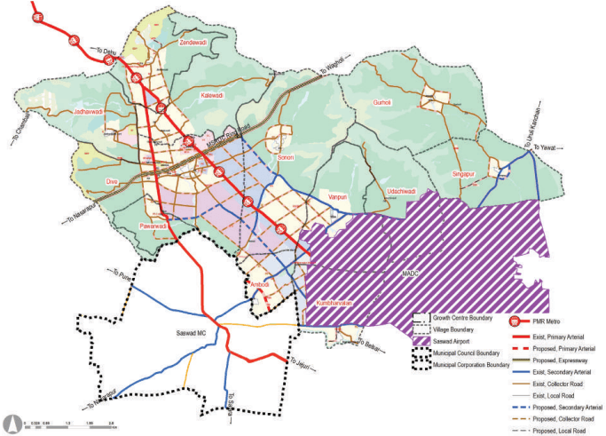
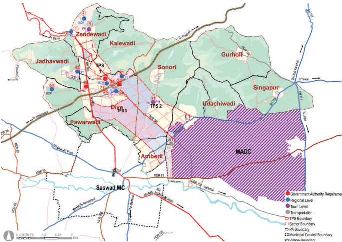
Saswad, proposed as a green-field development abutting the new proposed Chhatrapati Sambhaji Raje International Airport is positioned as an ‘Aerotropolis’. The reason behind the assigned role is to leverage upon the ecosystem that would then get flourished once the New International Airport activity commences. The new airport being a catalyst and a magnet, would require resident workforce during and post development of airport and for operations. Thus the name Aerotropolis, a town that caters to the needs of the Airport ecosystem. The Aerotropolis ecosystem consists of logistic park, agro & food processing cluster and business park.
Promote Logistics Park near to the Airport that will foster Fast Moving Consumer Goods and agro-food processing industries
Promote logistic & warehousing activities by consolidating cluster development leveraging upon high existing demand capitalising on the Metro corridor
Encourage Business Park development adjacent to the new airport.
Increase residential zone along Airport Road (60m wide road from Dive Ghat to new Airport) industrial cluster and logistic hub, promoting work-live concept
Promote Town Planning Scheme along the new proposed CSR Airport as part of implementation of the ‘Aerotropolis’ role.
Development of bypass to Airport Road and to NH 965 (SH 120 Palakhi Marg), avoiding congestion along Highway.
Development of Multi-modal Hub (MMH) along the Airport Road with Metro alignment, serving town level amenities
Develop a grid network of secondary and tertiary roads for a smooth movement within the Growth Centre
Promote self-sufficient town by proposing required amenities and utilities for the projected population
Protect all the natural streams in the Growth Centre
Establish green-blue links by connecting streams and forest
Town Planning Scheme at Sonori, Vanpuri and Dive themed as Aerotropolis (520.83 Ha)
Integrated Town Planning Scheme at Zendewadi and Kalewadi (140.17 ha)
Integrated Town Planning Scheme at Amboli, Dive, Pawarwadi, Sonori and Kumbharwalan (617.32 Ha)
Development of Airport road and Hadapsar-New Airport Metro
Multimodal Hub of area 3.64 ha at Dive at junction of MSRDC ring road and 60 m Airport Road
Development of Cultural Centre at Dive
Educational Complex of area 35.88 ha at Dive
Regional Center of area 11.97 ha at Dive
Medical College & Hospital of area 5.02 ha at Dive
Metro Depot of area 15.07 adjoining MADC
Tourist Centre and 2 Bio diversity Park of area 1.74 Ha, 89.23 ha and 174.92 ha at Zendewadi and Dive village.
Study & Research Centre for Warkari Sampraday of area 3.53 ha at Dive.
Public Housing of area 2.52 ha at Dive.
APMC of area 5.236 ha at Dive.
Stadium of area 7.5 ha at Jadhavwadi
32.2Existing Situation Analysis
Saswad comes under Purandar Taluka and comprises of 12 villages, namely, Jadhavwadi, Singapur, Dive, Vanpuri, Pawarwadi, Udachiwadi, Kalewadi, Gurholi, Ambodi, Kumbharvalan, Zendewadi, and Sonori. The total growth center area is about 7408.9 Ha. According to census 2011, population of Saswad growth center is 17,373 with 10,321 employment.
Key strength of Saswad Growth Centre is its location, adjoining of boundary MADC (i.e proposed CSR Airport) and Saswad Council. Another important strengthof the Growth Center show as its connectivity; it has been blessed with proposed MSRDC Ring Road, existing National Highway, State Highway and proposed Metro to New Airport.
Saswad Growth Center is located on the south-eastern side of Pune Metropolitan Region next to Saswad Municipal Council. It is surrounded by Loni Kalbhor GC on the Northen side. Proposed Chatrapati Sambhaji Maharaj Airport near saswad at south east. Upcoming airport will enhance the development in Saswad growth center which will boost the tourism and economy.
This Growth Center is connected by proposed 90M wide MSRDC Ring Road, NH 965 (SH 120 Palakhi Marg) originate at PMC from NH 65 to Pandharpur (Via Jejuri) and SH 119 which originate from NH 48 cross proposed airport and further meets to NH 65 (Pune - Solapur).
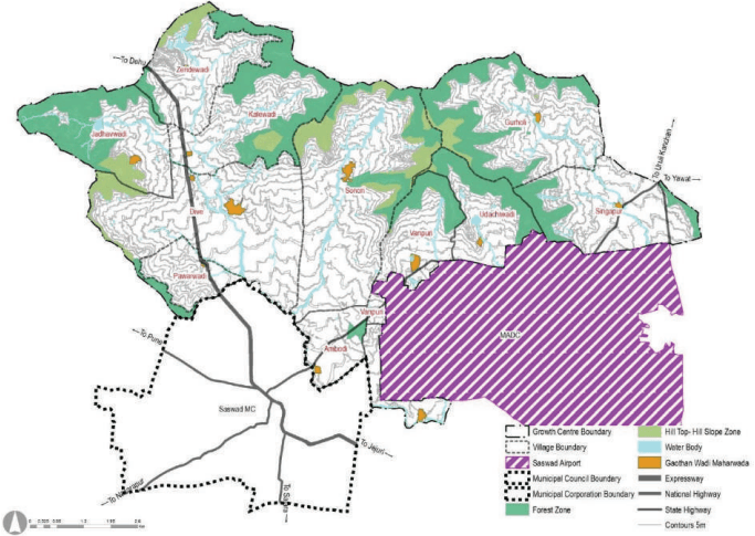
Figure 32.1: Location and Physiography
Chapter 32: Growth Centre: Saswad
Hill top hill slope are on the northern and eastern side of planning area. Jadhvwadi, Zendewadi, Kalewadi, Sonori, Gurholi, Udachiwadi, Vanpuri, Singapur and Pawarwadi are villages which covers the major part of Hill top hill slop. Major land use cover of Saswad is Forest, Hilltop Hillslope, and Agriculture.Forest cover is observed in parts of Jadhvwadi, Zendewadi, Kalewadi, Sonori, Gurholi, Udachiwadi, Vanpuri, Singapur and Pawarwadi. Most of Forest lands in this growth center are on Hill Top Hill Slope.as per District Environment Atlas of Pune District. Jadhavwadi, Singapur, Dive,Vanpuri, Pawarwadi, Udachiwadi, Kalewadi, Gurholi, Ambodi, Kumbharvalan, Zendewadi, and Sonori are covered by shallow soil except very small part of villages Singapur, Ambodi, Kumbharvalan and Vanpuri are covered with slightly deep soil.
There are one river (Karha), five primary nala , four secondary nala and five lake/pond present in this growth center. Karha River is originated at village Garade, Tal. Purandar flows from Saswad municipal council to south edge of village Kumbharvalan of this growth center and further meets to Nazare Prakalp (outside PMR). Major streams are flowing from northern hills towards south west side of growth center and meets Karha River.
Regional Plan 1997 Proposals
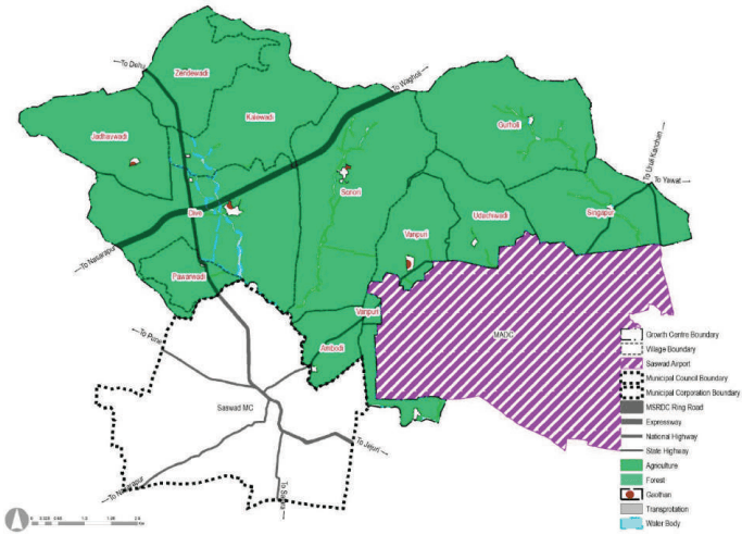
Saswad growth centre was not part of any sector under urbanization and thus villages of this growth center was part of Pune Dist. All villages were shown in Agriculture /No Development zone except Gaothan/Wadi. Residential development was only allowed as per Gaothan extension of 500m in agriculture zone. 110M of MSRDC Ring Road is provided.
The Residential Zone was not provided in RP and only gaothan extension was allowed. However sporadic development was observed near gaothan and along NH 965 (SH 120 Palakhi Marg) connecting PMC and Saswad MC. As per ELU and Contours area under 1:5 slope is shown as Hill top hill slope. In RP major land is delineated as Agriculture zone, even forest land is included in agriculture zone.
Figure 32.2: RP 1997 Zoning Map
Table 32.1RP 1997 Area Statement
Land use category
Area (ha)
Proportion of Total Developed Area (%)
Proportion of Total Area (%)
Residential
0.00
0.00%
0.00%
Gaothan
52.86
99.47%
0.71%
Commercial
0
0.00%
0.00%
Industrial
0
0.00%
0.00%
Public and semi public
0.00
0.00%
0.00%
Garden, Playground and Recreation
0.00
0.00%
0.00%
Public Utility
0.00
0.00%
0.00%
Transportation
0.28
0.53%
0.00%
Defense
0
0.00%
0.00%
Total Developed Area
53.14
100.00%
0.72%
Agriculture
7269.13
98.11%
Afforestation
0.00
0.00%
Green Belt
0.00
0.00%
Water bodies
86.73
1.17%
Forest
0.00
0.00%
Total Undeveloped Area
7355.86
99.28%
Total Area
7408.99
100.00%
Existing Land Use
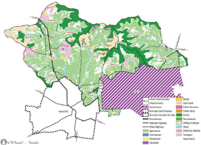
In Saswad Growth centre, the total Developed and Non-Developed area is 423.557 Ha and 6984.9 Ha respectively. Major land use cover of Saswad is Forest, Hilltop Hillslope, and Agriculture, with 15.20%, 8.12%, and 46.66% respectively of total growth center area. Sporadic residential development is observed near gaothan and along NH 965 (SH 120 Palakhi Marg), Gaothans are scattered across the planning area. The most dominant land use of Saswad is Agriculture. Saswad PA comprises of 46.66 % of Agriculture development of the total Developed Area. Transportation has highest share among the existing developed area of 84.49 Ha. Among the planning constraints, Hilltop Hill-slope and Forest together comprise of 23.32 % land of total land present in growth center . The streams of Karha river flowing towards South-West part aligning NH 965 (SH 120 Palakhi Marg), comprise of 199.9 Ha. A good amount of vacant land, 1598.15 Ha of area is found but present in sporadic manner. In existing situation 275.5 Ha of government land present in this growth center. Jadhavgad and Malhar gad forts are situated within the limit of GC and Purandar fort is situated in its proximity.
Chapter 32: Growth Centre: Saswad
Figure 32.3: Existing Land Use Map
Table 32.2Existing Land Use Area Statement
Land use category
Area (ha)
Proportion of Total Developed Area (%)
Proportion of Total Area (%)
Residential
47.48
11.21%
0.64%
Commercial
9.25
2.18%
0.12%
Industrial
8.01
1.89%
0.11%
Mixed
1.13
0.27%
0.02%
Public and semi public
272.5
64.34%
3.68%
Recreation
0.54
0.13%
0.01%
Public Utility
0.16
0.04%
0.00%
Transportation
84.49
19.95%
1.14%
Total Developed Area
423.56
100.00%
5.72%
Agriculture
3456.90
46.66%
Water bodies
199.98
2.70%
Vacant Land*
1598.24
21.57%
Forest
1126.24
15.20%
Hill Top Hill Slope
601.85
8.12%
Special Areas
1.74
0.02%
Total Undeveloped Area
6984.91
94.28%
Total Area
7408.47
100.00%
Traffic congestion along NH 965 (SH 120 Palakhi Marg), no bypass developed.
Scattered development within this growth center.
Absence of sewerage, storm water drainage and solid waste management sites.
32.3Proposed Role and Strategies
The role proposed for Saswad Growth centre is ‘Aerotropolis’.The rationale behind assigning this role to the GC is: 1. Because of it provides opportunity for green-field development abutting the new proposed CSR International Airport.
It can leverage upon the ecosystem that would then get flourished once the New International Airport activity commences.
Providing for new resident workforce for the during and post development of airport operations.
It provides opportunity to leverage upon the Aerotropolis ecosystem consisting of logistic park, agro & food processing cluster and business park.
In order to promote Fast Moving Consumer Goods (FMCG) due to its proximity to proposed CSR International Airport and connectivity via proposed MSRDC Ring Road.
Because of the High demand for commercial development likely to be generated by proposed extension to Metro (Hadapsar to New Airport) and 60m wide Airport Road.
Understanding the above, transit-oriented linear development is proposed along the Airport Road, the Metro and the SH 120 which is deemed to be a National Highway with a major node at Dive. Saswad Growth Centre is proposed to be a vibrant growth centre with a balance mixed of activities and is expected to host majority of the logistic activities.
Table 32.3Population Projections
Village
2011
2018
2031
2041
Ambodi
650
652
4662
8673
Dive
3,484
5,517
10979
15562
Gurholi
1,941
1,948
1925
1902
Jadhavwadi
609
611
604
597
Kalewadi
1,404
1,527
5743
9905
Kumbharvalan
1,271
1,317
5394
9453
Pawarwadi
1,006
1,185
1247
1236
Singapur
1,177
1,221
1280
1321
Sonori
2,409
2,778
7179
11421
Udachiwadi
843
905
1003
1074
Vanpuri
1,079
1,149
5274
9369
Zendewadi
1,500
1,654
5925
10127
Total
17373
20465
51215
80641
Chapter 32: Growth Centre: Saswad
The proposed generated employment (URGD method) for Growth Centre for the year 2041 is 77,644 employees while the proposed residential density is about 125 ppl/ha (12500 p/sq km).
For the planning of public facilities distribution, the Saswad Growth Center is divided into two sectors. Sector 1 consists of Zendewadi, Jadhavwadi, Dive, Kalewadi, and Pawarwadi villages while sector 2 consists of Vanpuri, Udachiwadi, Gurholi, Ambodi, Kumbharvalan and Singapur villages.
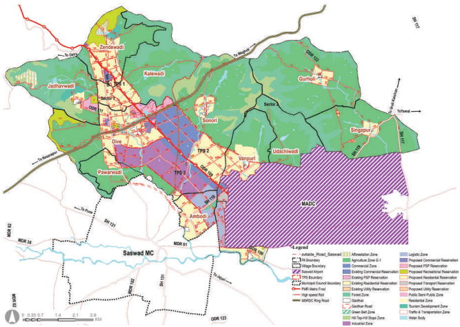
The boundaries of this planning division are shown on the Proposed Zoning Map. The projected sector-wise population statement is in Table 32.4
Table 32.4Projected Population - Sectors
Sector
2011
2018
2031
2041
Sector 1
8003
10,494
24498
37427
Sector 2
9370
9971
26718
43214
Total
17373
20465
51215
80641
The proposed zoning would guide and determine the optimal and efficient land use for the next 20 years. The proposed zoning plan is an output of existing land use and physical conditions analysis, understanding of most pressing issues of the Growth Center, local knowledge of the place and deployment of five planning goals and allied physical planning strategies. The proposed zoning area statement is presented in Table 33.4.
Figure 32.4: Proposed Zoning Map
Table 32.5Proposed Zoning Area Statement
Land use category
Area (ha)
Proportion of Total Devel-oped Area (%)
Proportion of Total Area (%)
Residential
1054.85
43.25%
14.24%
Gaothan
40.68
1.67%
0.55%
Commercial
290.47
11.91%
3.92%
Industrial
324.67
13.31%
4.38%
Public semi Public
110.26
4.52%
1.49%
Transport
428.17
17.56%
5.78%
Logistic Zone
132.18
5.42%
1.78%
Tourism
49.46
2.03%
0.67%
Public Utilities
8.24
0.34%
0.11%
Total Developed Area
2438.98
100.00%
32.92%
Afforestation Zone
47.83
0.65%
Agriculture
2901.92
39.17%
Forest
1393.63
18.81%
Hilltop Hillslope
367.61
4.96%
Green Belt
6.75
0.09%
Recreational
103.08
1.39%
Water Body
149.13
2.01%
Total Non-Developable Area
4969.95
67.08%
Total
7408.93
100.00%
The projected resident workforce based on the projected population through the URGD method is 44,122. Considering the proposed economic activities of all the growth centres, employment distribution was proposed based on the envisaged sectoral split for that Growth Centres. Accordingly, the employment to be generated for the Growth Centre for the year 2041 is estimated to be 77,095. The proposed residential density is about 125 PPH (12,500 persons/sq km).
Proposed zoning ensures that the sectoral development goals are clearly conveyed through it. Proposed sectoral goals and their corresponding physical planning strategies are mentioned in Table 32.6.
Table 32.6Goals and Physical Planning Strategies
Goals
Development Sector Addressed
Physical Planning Strategies
Prudent
Employment and housing
Work- Live Hubs
Convenient
Roads and mass transport
Movement Lattice
Resilient
Environment protection
Green- Blue connectors
Efficient
Infrastructure and utilities
Decentralized resource management
Self- sufficient
Social facilities
WalkableNeighbourhoods
Chapter 32: Growth Centre: Saswad
For Saswad Growth Center, the Work-Live concept is applied by:
Envisioned as self-sustaining Aertropolise.
designating residential zones within 500m around industrial and commercial zones to minimize work related trips for at least 30% of the resident workforce;
Allocating 615.14 ha new industrial, and commercial zones along the Highway edging the MADC, to reduce travel time for commuting workforce from within & other Growth Centers
Regional Centre is proposed at Dive, at the central location of the Growth Centre
Out of the total proposed industrial zone over 18,660 Ha, industrial use over 230 Ha is envisaged in Saswad Growth Centre, both based on projected employment and 50 workers/ha density.
The industrial development is proposed considering a total 8973 employment by 2041, which further translates to 324.67 ha area of Industrial Zone, considering worker density of 50 workers/ ha and topping up by 30% (15% road, 10% open space, 5% amenity).The industrial zone as per ELU was 8.01 ha while there is no provision for industrial zone in RP 1997. The main purposed of locating industrial along the Airport road was to provide easy accessibility via Metro and promote the supportive infrastructure required for Aerotropolis.
Considering a 55 sqm built-up area/person, the total land requirements for the logistics zone for the Study area works out to be 2020 ha, out of which 100 ha is anticipated within the Saswad growth centre. However, taking into consideration the existing trend of warehousing and supplementary industries and the proposed strategic infrastructure projects, 132.18 ha.of logistic zone is proposed. This zone, being proposed along SH 119 and nearer to the junction of SH 119 and 60 m Primary Arterial Airport Road , Provides connectivity to the logistic centres of Ambodi and Kumbharvalan.
The planning intent is to leverage upon the upcoming international airport and support its ecosystem, ie supporting the FMCG, agro-processing and packaging industries.
Land requirement for the residential zone is estimated based on a net residential density of 125 PPH. Further, 45% add-on is considered to account for amenity (15%), open spaces (10%) and roads (20%). Accordingly, the total gross area required for the projected GC population of 80,641 by 2041 is estimated to be 940 Ha.
Considering the projected population, net residential density, proposed role and existing growth trends within the Growth Centre, 1054.85 Ha of gross residential zone is proposed.As per the Work Live hub concept, consolidated residential zoning is proposed in the Growth Centre. Residential development is proposed serving the industry and logistic areas of Dive and Sonori. Further residential development is proposed at Zendewadi along the Airport road and NH 965 (SH 120 Palakhi Marg).
Land requirement for commercial zone is estimated based on URDPFI guidelines i.e. 0.6 ha per 1000 population and topping up 30% (15% road, 10% open space, 5% amenity).The total commercial zone works out to be 63 Ha, while 290.47 Ha commercial zone is proposed to account for equitable distribution of commercial activities. Commercial node at Sonori, Dive and Zendewadi are proposed along the Metro corridor. Commercial development at Sonori is proposed to serve the logistic activities. The intent of proposing commercial zone along the Airport Road at Sonori and Dive, is to create a vibrant corridor of 1.5km along with retail and f&b activities. Regional Centre, Multimodal Hub and APMC are proposed centrally at Dive over government land. Another major commercial development is proposed at ‘Y’ junction at Zendewadi serving the residential development.
Tourism Zone:
Saswad region is bestowed with the religious and historical forts attractions with a potential for growth in tourism related activities. Considering existing tourist attractions, Tourism zone is proposed at two major nodes. One of
the node is in the village Zendewadi near Dive ghat and at Jadhavwadi near existing Jadhavgad fort.
The movement lattice concept also includes a mass transit corridor running through the Growth Center centre, MSRDC Ring Road crossing the Centre to encourage >50% of the residents to use mass transport for their daily commute.
Development of ODR 109 and part of VR into 60m wide Airport road
Parallel system (30m road) is proposed to Airport road on both of its sides at Sonori, Dive and Vanpuri, so as to balance out the traffic flow.
Grid-iron pattern of Collector roads (15-24m wide) is proposed within the growth centre.
Collector roads (15-24m wide) follow spacing of 300-500m while Secondary arterial (30-45m wide) follow a grid of 1 to 2 km. covering all the residential zone.
Bypass of NH 965 (SH 120 Palakhi marg) at Saswad MC is proposed at Village Ambodi
Mass transit lattice: development of Metro line from Hadapsar to the new CSR Airport along Airport road.
Secondary arterials has the flexibility to run a dedicated Bus service for faster transport and support the feeder system & last mile connectivity
Service road of 18 M is proposed of 90M MSRDC Ring Road.
Grade separated interchange is proposed at junctions of MSRDC Ring Road and Airport Road.
All the existing roads to be redeveloped and proposed roads are to be designated with at least 3m wide footpath on either side of the road, as the ‘pedestrian right of way’ and as a ‘hawker-free zone’.
Figure 32.5: Proposed Transport Network Map
Chapter 32: Growth Centre: Saswad
Table 32.7Proposed Transport Network Statement
Road Category
Road names/ ROWs
Proposed ROWs
Authority
Total Length (km)
Cost of Road Development
Primary
NH 965
60
NHAI
1.19
NH 965
45
NHAI
4.82
ODR 109
60
ZP
4.00
VR 3
60
ZP
2.74
Secondary
SH 117
45
PWD
1.52
SH 119
45
PWD
6.96
MDR 61
30
PWD
1.99
VR (Total)
30
ZP
4.85
Tertiary
ODR 109
24
PWD
0.88
VR 12
24
PWD
1.46
ODR 109
18
ZP
1.00
ODR 111
18
ZP
1.10
ODR 122
18
ZP
3.12
VR (Total)
18,15
ZP
36.25
Local
ODR 109
12
ZP
0.79
ODR 111
12
ZP
0.36
ODR 122
12
ZP
0.77
VR (Total)
12,7
ZP
1.58
DP Roads
Primary
MSRDC Ring Road
90
MSRDC
7.98
-
Primary Arterial
60
PMRDA
0.45
14.05
PMRDA Ring Road
65
PMRDA
0.00
-
Bypass
45
NHAI
1.28
-
Secondary
45
PMRDA
0.70
19.65
30
PMRDA
6.84
99.75
Tertiary
24
PMRDA
7.84
95.55
18
PMRDA
35.00
253.00
15
PMRDA
31.32
157.85
Local
12
PMRDA/ProposedULB
2.04
15.00
Total Road Length
83.45
653.85
“Resilient” goal aims to strengthen the inbuilt capacity of Growth Centres to sustain in adverse climatic conditions such as flooding, landslide, air pollution and climate change by protecting environmental features and land susceptible to such threats. The goal also aims to make these features accessible for passive recreation to cover the existing deficit of recreational spaces. It translated into the plan employing the Green- Blue Connector Strategy.
‘Green’ refers to the protected forests and slopes; ‘Blue’ refers to the protected water bodies; and ‘Connector refers to the proposed avenues and streams/ canals. Avenue is conceived as a tree-lined road, with NMT provision, linking the Green and Blue features.
The existing forest areas at Jadhavwadi, Zendewadi, Kalewadi, Sonori, Gurholi, Udachiwadi, Vanpuri, Singapur and Pawarwadi are designated as protected areas.
All existing streams to be protected.
These protected Green-Blue features are recommended to be connected by a 30-45 m wide secondary arterial road that would be upgraded as a tree-lined avenue by developing NMT corridors (>3 m each) on both sides of the road and segregated from footpaths.
Green lungs are proposed within 500 m walkable distance covering an area of 176.02 ha. These green lungs include active and passive recreational spaces. The total active recreational space works out to be 16.26 ha that include playgrounds, sport complex, stadium and multi-purpose ground. And the total passive recreational space works out to be 159.73 ha that include gardens, town park/ regional park, bio diversity park and green belt.
This concept is applied as follow:
Two Sewage treatment plant is proposed, 1st STP is proposed at village dive to covering 0.41 Ha of area while 2nd STP is proposed at sonori covering 0.39 Ha of area.
Two Water treatment plant is proposed, 1st WTP is proposed at village zendewadi to covering 0.62 Ha of area while 2nd STP is proposed at gurholi covering 0.51 Ha of area.
2 Solid waste management sites of area 2.89 ha are proposed, at Jadhavwadi and Singapur village serving 5-8km radius.
Currently 11 cremation ground are present in the Growth Centre, thus expansion of which is proposed and no new additional cremation grounds are proposed. A burial ground is proposed at Dive village.
Table 32.8Proposed Infrastructure Demand
Infrastructure System
Demand (2041)
Unit
Area Requirement (In Ha)
Utility Sites
Total Area
Water Supply
5.84
MLD
0.1
2 WTPs
1.12 ha
Sewerage
5.81
MLD
0.87
2 STPs
0.80 ha
Solid Waste
16.13
Tones/day
5
2 SWM
2.89 ha
This goal is set to increase the livability index of the Growth Centre. To do that, amenities are proposed within 500 m distance, leveraging the concept of Walkable Neighbourhoods. The concept entails providing basic infrastructure and services for education, health, sports, and recreation within the neighbourhood to have easy access to them by foot.
Amenity provision is made for the projected population by 2031(51,215 ppl)
Chapter 32: Growth Centre: Saswad
Neighbourhood level amenities are located within a 500 m-1000 m radius from residential zones and are connected by collector/local roads to improve their accessibility from other neighbourhoods.
Saswad Growth Centre has been blessed with strategically located government owned lands and thus a cluster of amenities are proposed over these areas serving well the multiple activities envisioned in the Growth Centre.
Education: Primary Schools and Secondary Schools are clubbed together and provided at newly opened up residential areas. Wherever possible, expansion to the existing ZP schools is proposed with proper road access to each amenity. Total 3 Primary + Secondary schools are proposed and 1 primary school extension with proposed secondary school, 3 PS extension are proposed. A Education Complex is proposed at Dive considering regional level.
Health: HC provided considering walking radius within Neighbourhood. A medical college and hospital is proposed at Dive considering regional level. While considering spatial distribution, additional 4 HCs of area 0.49 Ha are proposed.
Socio-Cultural: Community halls are provided considering walking distance within a neighbourhood. One cultural centres and Social welfare centre are proposed at Dive.
Open Space: Considering the walkability, open spaces are spatially distributed, such that they acts as a breathing lungs for surrounding neighborhoods. Thus 5 garden of size 3.58 Ha. are proposed in Dive, Kalewadi, Sonori, Ambodi and Jadhavwadi. Similarly, 8 playgrounds of size 4.85 ha are proposed in Dive, Kumbharvalan, Ambodi, Vanpuri, Kelewadi, Parawadi, Sonori and, Zendewadi. Biodiversity Park is proposed over 89.23 ha of government land creating another tourist attraction.1 Stadium is proposed of 7.5 ha area at Jadhavwadi. The sports complex is provided at the newly opened up residential areas in Dive, again on government land and accessible by 45M NH 965 (SH 120 Palakhi Marg).
Commercial:Shopping Centre/market is provided at existing commercial nodes or near existing settlements or on available amenity spaces. Total 2 shopping centres and 1 Market are proposed considering spatial distribution. Regional Centre is proposed at Dive and tourist centres are provided at Zendewadi.
Utility: 1st WTP is provided at Zendewadi and 2nd at Gurholi, 2 STPs are provided considering the topography and gravity system; One SWM site is provided at Jadhvwadi based on clustered approach to serve Saswad growth centre.
Transport: Metro depot is proposed at the junction of 60m Airport road and SH 119 adjoining the proposed Airport. Multimodal Hub is proposed over government-owned land adjoining the proposed MSRDC Ring Road and 60m Airport road. Parking spaces are proposed near amenities that provide for a larger crowd congregation.
Civic: A fire station is provided along the 60m Airport road on government land within Dive. Existing crematorium and burial grounds are maintained and expanded wherever required and feasible.
Residential; Public housing and Housing for dis-housed shall be maintained.
Civic facilities requested by various government authorities: In additions to above, amenities such as District Court, Maharashtra State Warehousing Corporation, Study & Research Centre and APMC are proposed at Dive village.1 Electric Sub-station is proposed at Singapur village.
Table 32.9Summary of Land Ownership of Proposed Amenities
Land Ownership
No of Amenity
Total Area (ha)
Government Land
32
241.23
Private Land
32
33.85
Other
1
0.50
Total
65
275.58
Town Planning Scheme: PMRDA envisages implementing the Development Plan proposals by enabling the provision of Town Planning Schemes, which will considerably reduce liability towards the direct cost of acquisition of land required for social and physical infrastructure.Two Town Planning Scheme are proposed, one at Zendewadi and another at Dive (including Zendewadi, Kalewadi, Ambodi, Kumbharvalan, Sonori, Dive and Vanpuri villages). The reservations proposed to be developed using the TPS mechanism are as follows: 2. Strategic Projects :Education Complex, Regional Centre, Tourist Center.
Reservations: Metro Depot, Multimodal Hub, Shopping Centre,Community Hall, Health Centre, Garden, District Court, Water pump, Playground, PS,SS.
The other proposals/reservations of the Development Plan are proposed to be acquired and developed through the mechanism of Accommodation of Reservation and Transfer of Development Rights (TDR) policy. It is estimated that all proposed roads and 50% of the public reservations will be acquired through TDR/FSI/ AR. Remaining
The remaining reservations will be acquired under the provision of the Land Acquisition Act by paying monetary compensation.