Uruli Kanchan is positioned as an ‘Agro-Processing Hub’, and the key reasons for this are as follow:
-
This area falls under the protected agriculture area of the irrigation command area, thus promoting the agroprocessing activities
-
Leverage the opportunity to foster FMCG development due to added connectivity through nearby proposed CSR International Airport at Saswad
-
Crescent Railway and MSRDC Ring Road will further enhance connectivity for the cargo facility
-
Leverage existing mature setup of green-house and horticulture in the area
-
Existing residential development at Uruli Kanchan and Koregaon Mul provides an opportunity for a Work-live hub
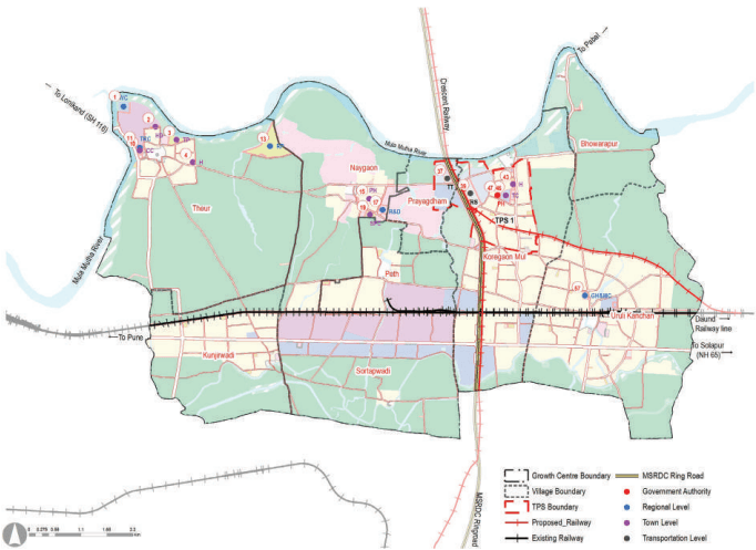
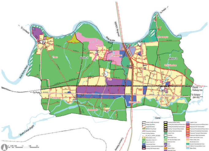
Considering the above, three distinct nodes are proposed in the GC at Uruli Kanchan, Koregaon Mul and Theur. Industrial zone , promoting agro-processing activities is proposed between Railway and Highway, leveraging its role of Agro Processing Hub where as a logistic zone, supporting the FMCG segment is proposed at Koregaon Mul adjoining the Crescent Railway station. Theur forms one of the major tourist destination of PMR
| Villages | 2011 | 2018 | 2031 | 2041 |
|---|---|---|---|---|
| Bhowrapur | 823 | 859 | 894 | 918 |
| Koregaon Mul | 4,818 | 14871 | 17,369 | 19,887 |
| Kunjirwadi | 8,421 | 10573 | 12,782 | 14,399 |
| Naygaon | 2,589 | 2913 | 3,398 | 3,753 |
| Peth | 2,076 | 2347 | 2,306 | 2,272 |
| Prayagdham | 1,899 | 2589 | 3,761 | 4,623 |
| Sortapwadi | 6,366 | 7174 | 8,391 | 9,279 |
| Theur | 9,674 | 10020 | 9,829 | 9,671 |
| Uruli Kanchan | 30,305 | 40816 | 47,358 | 52,135 |
| Total | 66,971 | 92161 | 106,088 | 116,937 |
The projected resident workforce based on the projected population through the URGD method is 52,032. Considering the proposed economic activities of all the growth centres, employment distribution was proposed based on the envisaged sectoral split for that Growth Centres. Accordingly, the employment to be generated for the Growth Centre for the year 2041 is estimated to be 38957. The proposed residential density is about 125 PPH (12,500 persons/sq km).
For the planning of public facilities distribution, Uruli Kanchan GC is divided into two sectors. Theur, Naygaon, Peth, Prayagdham, Kunjirwadi and Sortapwadi form the western sector. Koregaon Mul, Uruli Kanchan and Bhowrapur form the eastern sector.
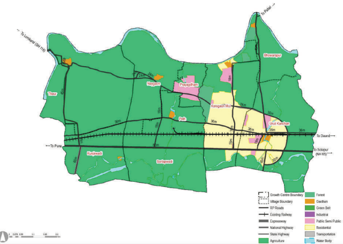
The boundaries of this planning division are shown on the Proposed Zoning Map. The projected sector-wise population statement is in Table 31.4.
| Sector | 2011 | 2018 | 2031 | 2041 |
|---|---|---|---|---|
| Sector 1 | 35,946 | 35614 | 65,621 | 72,940 |
| Sector 2 | 31,025 | 56547 | 40,467 | 43,997 |
| Total | 66,971 | 92161 | 106,088 | 116,937 |
The proposed zoning would guide and determine the optimal and efficient land use for the next 20 years. The proposed zoning plan is an output of existing land use and physical conditions analysis, understanding of most pressing issues of the Growth Center, local knowledge of the place and deployment of five planning goals and allied physical planning strategies. The proposed zoning area statement is presented in Table 31.5.
Figure 31.4: Proposed Zoning Map
| Land use category | Area (ha) Poproepdo Artrieoa | n of Total Devel- Proportion(%) (%) | of Total Area |
|---|---|---|---|
| Residential | 1529.19 | 50.17 | 21.20 |
| Gaothan | 45.85 | 1.50 | 0.64 |
| Commercial | 250.64 | 8.22 | 3.47 |
| Industrial | 309.36 | 10.6 | 4.29 |
| Logistics | 42.64 | 1.40 | 0.59 |
| Tourism Development | 36.98 | 1.21 | 0.51 |
| Public and semi public | 277.38 | 9.10 | 3.85 |
| Public Utility | 11.99 | 0.39 | 0.17 |
| Traffic & Transportation | 544 | 17.85 | 7.54 |
| Total Developed Area | 3048.30 | 100 | 42.26 |
| Agriculture (G1) | 3507.29 | 48.62 | |
| Water bodies | 277.87 | 3.85 | |
| Green Belt | 204.10 | 2.83 | |
| Forest | 119.42 | 1.86 | |
| Recreational | 56.22 | 0.78 |
| Total Non-Developable Area | 4164.77 | 57.74 |
|---|---|---|
| Total | 7213.07 | 100.00 |
Translating Goals into the Plan
Proposed zoning ensures that the sectoral development goals are clearly conveyed through it. Proposed sectoral goals and their corresponding physical planning strategies are mentioned in Table 31.6
| Goals | Development Sector Addressed | Physical Planning Strategies |
|---|---|---|
| Prudent | Employment and housing | Work- Live Hubs |
| Convenient | Roads and mass transport | Movement Lattice |
| Resilient | Environment protection | Green- Blue connectors |
| Efficient | Infrastructure and utilities | Decentralized resource management |
| Self- sufficient | Social facilities | Walkable Neighbourhoods |
For this Growth Center, the Work-Live concept is applied by:
-
Designating residential zones within 500 m around logistics, industrial and commercial areas and town centre to minimise work-related trips for at least 30% of the resident workforce
-
Developing logistic and commercial nodes around the intersection of Crescent Railway station and Ring Road to reduce travel time for the workforce to commute within the Growth Centre as well as to and fro other Growth Centers
-
Proposing Town Centre at Koregaon Mul, serving the entire GC and the surrounding rural area
Out of the total industrial zone of 18860 ha proposed for the Study Area, based on 50 workers/ha, 309.63 ha of industrial development is envisaged in Uruli Kanchan Growth Centre.
The industrial zone as per ELU was 40.4 ha, whereas RP 1997 did not propose any industrial zone. Considering the existing horticulture (green houses) and allied agricultural activities , envisaged Agro-processing role, and strategic infrastructure proposals within the Growth Centre, industrial zone over an area of 309.63 ha is proposed in Uruli Kanchan Growth Centre, in alignment with the requirement The industrial zone is proposed along the existing railway line and the national highway, expected to promote agro-tech and its ecosystem within the Growth Centre.
The total land requirement for the logistics zone for the Study Area works out to be 2040 ha by considering 55 sqm built-up-area/person, out of which 42.64 ha is anticipated within Uruli Kanchan Growth Centre.
Major regional mobility projects such as Crescent Railway and MSRDC Ring Road pass through Uruli Kanchan Growth Centre. This provides an excellent opportunity to promote logistic activities in Uruli Kanchan, and the same has been envisaged in the CTTS report.
The logistic zone would also supplement the proposed role, i.e. agro-processing hub. Thus, it is proposed over 42.64 ha at Koregaon Mul, adjoining the Crescent Railway and the MSRDC Ring Road.
Land requirement for the residential zone is estimated based on a net residential density of 125 PPH. Further, 45% add-on is considered to account for amenity (15%), open spaces (10%) and roads (20%). Accordingly, the total gross area required for the projected GC population of 116,937 by 2041 is estimated to be 1360 ha, whereas the residential use proposed covering 1529.19 ha almost aligns with the requirement. The increase in residential zone is on account of gaothan expansion at Peth, Theur and supporting the intervention of logistic activities, Crescent railway station at Koregaon Mul.
As per the Work Live hub concept, consolidated residential zoning is proposed in the Growth Centre. High-density residential developments are observed in Koregaon Mul (452.01 ha) and Uruli Kanchan (534.86 ha). 75% of the proposed residential development in the GC is proposed in these two villages, considering the existing matured residential developments and current development trends in these villages. Kunjirwadi (212.17 ha), Theur (91.5 ha) Naygaon (42 ha) and Peth (51.88 ha) form the other major residential areas of the Growth Centre. .
Commercial nodes are proposed at strategic locations primarily with an intent to integrate these developments with transport hubs, thus encouraging intense development along the transit
Land requirement for the commercial zone is estimated based on URDPFI guidelines, i.e. 0.4 ha per 1,000 population and topping up 30% (15% road, 10% open space, 5% amenity). The total commercial zone works out to be 25.64 ha.
The commercial node at Koregaon Mul is proposed over 96.45 by integrating it with the proposed Crescent Railway station at Koregaon Mul. Further, the Town Centre over 5 ha is proposed in the vicinity of this station. The second commercial node is proposed at Uruli Kanchan adjacent to the existing railway station on Pune-Daund Railway Line. Another major commercial development is proposed along the Pune-Solapur State Highway, building upon the existing trend of warehousing and other allied services development in this transit corridor. The fourth node is proposed along the NH 548 DD at Kunjirwadi, leveraging the current commercial activities along the highway.
The movement lattice concept also includes a mass transit corridor running through the Growth Center centre, high-speed rail crossing the Centre and Ring Road to encourage >50% of the residents to use mass transport for their daily commute.
-
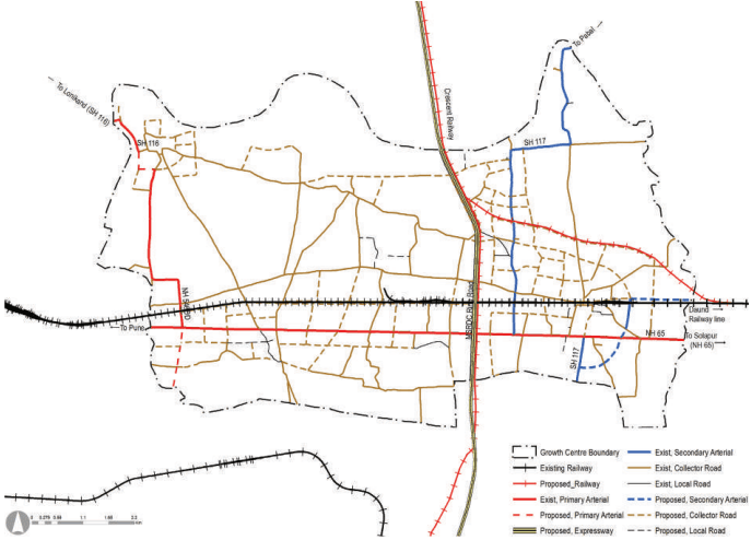
A parallel system (24 & 15 m road) to NH-65 is proposed on either sides at Uruli Kanchan, Sortapwadi and Kunjirwadi, bypassing the congested section and disconnecting it from local traffic. This bypass should be one of the top development priorities of the Growth Centre.
-
Another parallel system to SH-117 is proposed in north south direction
-
while the connector road as recommended in RP 1997 is proposed to assist in modulating the traffic.
-
Developing a bypass to Theur Gaothan, connecting NH 548 DD Road, avoiding the congestion within the Gaothan.
-
Grid-iron pattern of collector roads (15-24 m wide) is proposed at Kunjirwadi, while a radial pattern is proposed at Uruli Kanchan based on the existing alignments.
-
Collector roads (15-24 m wide) follow spacing of 300-500 m. Secondary arterial (30-45 m wide) follows a grid of 1 to 2 km covering the entire residential zone.
-
Crescent Railway (Talegaon -Chakan -Shikrapur-Uruli Kanchan) passes through the Growth centre and runs aligned with MSRDC Ring Road.
-
Secondary arterials have the flexibility to run a dedicated bus service for faster transport and support the feeder system and last-mile connectivity.
-
All proposed roads are to be designated with at least 3m wide footpath on either side of the road, as the ‘pedestrian right of way’ and ‘hawker-free zone.’
Figure 31.5: Proposed Transport Network Map
| Road Category | Road names/ ROWs | Proposed ROWs | Authority | Total Length (km) |
| Primary | NH548DD | 60 | NHAI | 6.95 |
| NH65 | 60 | NHAI | 11.46 | |
| Secondary | SH117 | 45 | PWD | 8.6 |
| Tertiary | MDR120 | 24 | PWD | 1.25 |
| MDR138 | 24 | PWD | 15.53 | |
| MDR34 | 24 | PWD | 8.56 | |
| MDR58 | 24 | PWD | 1.63 | |
| ODR113 | 18 | ZP | 0.291 | |
| ODR137 | 18 | ZP | 4.99 | |
| ODR139 | 18 | ZP | 5.4 | |
| ODR136 | 18 | ZP | 0.543 | |
| Local | VR (Total) | 15 | ZP | 9.14 |
| DP Roads | ||||
| Primary | MSRDC Ring Road | 110 | MSRDC | 5.11 |
| Expressway | 90 | MSRTC | 0 | |
| PMRDA Ring Road | 65 | PMRDA | 0 | |
| Secondary | 45 | PMRDA | 0 | |
| 30 | PMRDA | 3.4 | ||
| Tertiary | 24 | PMRDA | 12.85 | |
| 18 | PMRDA | 9.18 | ||
| 15 | PMRDA | 41.11 | ||
| Local | 12 | PMRDA | 5.02 | |
| Total Road Length | 151.014 |