Figure 38.5: Physiography 429 Figure 38.30: Existing Land Use Map 455
Figure 38.6: Existing Land Use Map 430 Figure 38.31: Demographic projections
Figure 38.7: Demographic projections and the rural catchment 457
the rural catchment 431 Figure 38.32: Proposed Zoning Map 458
Abbreviations
AAI - Airport Authority of India ARAI - Automotive Research Association of India AQI - Air Quality Index ARAI - Automotive Research Association of India ASI - Archeological Survey of India ATC - Air Traffic Control BFSI - Banking, Financial Services and Insurance BMCC - Brihan Maharashtra College of Commerce CAGR - Cumulative Annual Growth Rate CBD - Central Business District CG - Cremation ground BG - Burial Ground BOD - Biochemical Oxygen Demand CB - Cantonment Board C - College CC - Community Center CH - Community Hall COD - Chemical Oxygen Demand CMP - Comprehensive Mobilty Plan CPCB - Central Pollution Control Board Cr - Crores CT - Census Town CTTS - Comprehensive Traffic and Transportation
Study CWPR - Central Water and Power Research DCPR - Development Control and Promotion Regulation DES - Directorate of Economics and Statistics DPR - Detailed Project Report DTV - District Tourist Visits ELU - Existing Landuse ESA - Ecologically Sensitive Area ETP - Effluent Treatment Plant FDI - Foreign Direct Investment FMCG - Fast-moving consumer goods FS- Fire Station FSI - Floor Space Index FSL - Full Supply Level FTV - Foreign Tourist Visits G - Garden GCNP - Ground Control Network Point GDP - Gross Domestic Product GEMS - Global Environmental Monitoring System GIS - Geographical Information System GI- Galvanized Iron GSD- Ground Sample Distance GSDA - Groundwater Directorate of Surveys & Development Agency GST - Goods and Services Tax
H - Hospital
Ha - Hectare
HEMRL- High Energy Materials Research Laboratory
HFL- High Flood Line
HH- Household
ICD - Inland Container Depot
IGR - Inspector General of Registration
IISER - Indian Institute of Science Education and Research
IT - Information Technology
ITES - Information Technology Enabled Services
ITP- Integrated Township Policy
JNPT - Jawaharlal Nehru Port Trust
LIG - Low Income Group
LIS - Land Information System
LPCD - liter per capita per day
km - Kilometer
MADC - Maharashtra Airport Development Corporation
MDR - Major District Road
MHADA - Maharashtra Housing Area Development Authority
Corporation
MINARS - Monitoring of Indian National Aquatic
Resource
MIT - Maharashtra Institute of Technology
MJP - Maharashtra Jeevan Pradhikaran
MLD- millions of liter per day
Mm3 - cubic millimetre
MMR - Mumbai Metropolitan Region
MoEFCC - Ministry of Environment Forest and Climate
Change
MoU - Memorandum of Understanding
MPCB - Maharashtra Pollution Control Board
MPN- Most probable number
MRTP Act - Maharashtra Regional Town Planning Act
MSETL - Maharashtra State Electricity Transmission Limited
MSL - Mean Sea Level
MSME - Micro, Small and Medium Enterprises
MSRTC - Maharashtra State Road Transport
Corporation
MTDC- Maharashtra Tourism Development Corporation
MWRRA - Maharashtra Water Resources Regulatory
NA - Not Available
NAINA - Navi Mumbai Airport Influence Notified Area
NASSCOM - National Association of Software and
Service Companies
NCL- National Chemical Laboratory
NDA - National Defense Academy
NH - National Highway
NMT- Non-motorized Transport
NP - Nagar Panchayat
NRW - Non revenue water
NUTP - National Urban Transport Policy
NWMP-National Water Quality Monitoring Program
ODR- Other District Road
PCU - Passenger Car Unit
PHC- Primary Health Centre
PMPML- Pune Mahanagar Parivahan Mahamandal Limited
PPP- Public Private Partnership
PS - Primary School
PWD - Public Works Department
RADPFI - Rural Area Development Plan Formulation
and. Implementation
RC - Regional Centre
REIT - Real Estate Investment Trust
RERA - Real Estate (Regulation and Development) Act
R&D- Research and Development
ROB - Road over bridge
ROW - Right of Way
RUB - Road under Bridge
RP - Regional Plan
pH - Pote
ntial of Hydrogen
PG - Playground
SC/ M - Shopping Centre/ multipurpose Market
SEZ- Special Economic Zone
SH- State Highway
SME - Small and Medium Enterprises
SPA - Special Planning Authority
SPC - Sports Complex
SPV - Special Purpose Vehicle
SRA - Slum Rehabilitation Authority
SS - Secondary School
STP - Sewerage Treatment Plant
NIV - National Institute of Virology
PCMC - Pimpri Chinchwad Municipal Corporation
PLU- Proposed Landuse
PMC- Pune Municipal Corporation
PMR- Pune Metropolitan Region
PMRDA - Pune Metropolitan Region Development
Authority
RP- Regional Plan
RSPM - Respirable Suspended Particulate Matter
SPA - Special Planning Area
SWM- Solid Waste Management
TDR - Transfer of Development Rights
TEU - twenty-foot equivalent units
TC - Town Centre
TMC - Thousand million cube feet
TPS - Town Planning schemes
ULB - Urban Local Bodies
UNESCO - United Nations Educational Scientific and
Cultural Organization
URDPFI - Urban and Regional Development Plans
Formulation and Implementation
URGD - Urban Rural Growth Decadal
VR - Village Road
WFPR - Work Force Participation Rate
WTP - Water Treatment Plant
ZP- Zilla Parishad
Chapter 20: Growth Centre: Chakan
20.1Summary
Chakan is envisioned as an “Automobile Hub and Regional Centre.” It is already an established automobile manufacturing centre. Future development of this area will be shaped by a number of infrastructure projects in the region, such as the joint alignment of PMRDA and MSRDC Ring Roads, Pune-Nashik High-Speed Railway Line and Crescent Railway Line.
A regional centre will fulfil the need of a central business district in the Northern part of PMR and support the business, financial and convention requirements of the industrial hub.
Open up vacant/agricultural lands abutting the industrial area for residential development and equip them with amenities to promote the Work-Live concept.
Consolidate industrial and logistic development around existing MIDC and proposed MIDC Phase- 5 for the efficient functioning of proposed industrial zoning.
Improve the efficiency of industrial activities by strengthening the logistics hubs through strong regional infrastructure projects such as - widening of existing Talegaon-Ahmedpur, Dis. Latur ( Via Shrigonda) National highway (NH-548D), developing logistics hubs along the combined PMRDA and MSRDC Ring Road.
Providing connectivity through the proposed Crescent Railway Line (freight line) connecting Miraj rail route with Lonavala rail route via UruliKanchan, Sanaswadi, Chakan and Ambi for cargo movement to decongest the rail network within PMC, PCMC and serve industrial estates located along it.
Develop a grid network of secondary and tertiary roads for a smooth movement within the Growth Centre.
Improve accessibility to industrial zone for workers/residents through proposed Pune-Chakan Metro Line and its offshoot until newly planned MIDC Phase-5.Establish green-blue links by designating green beltwithin blue line of the Indrayani River.
Promote self-sufficient town by proposing required amenities and utilities for the projected population.
For affordable housing, public housing are provided at Mhalunge, Sawardari,Yevalewadi, Chimbali, Kharabwadi, Nighoje.
Utilization of available Gairan and Government Land.
Multimodal hubs of total area of 5.27 ha at Kuruli and Khalumbare,
Two Regional Centres at Sadumbare (17.82 ha) and Mhalunge (33.22 ha)
Business Centre at Nighoje (11.95 ha)
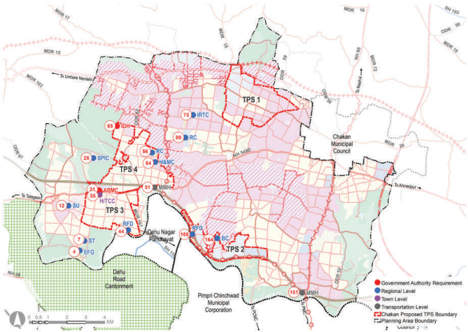
Town Planning Scheme: TPS 1 - Industrial along with logistic and residential (695.28 ha), TPS 2 - Logistic along with industrial and commercial (476.67 ha), TPS 3 - Residential (540.27 ha), TPS 4 - Residential (828.17 ha)
Industrial research and training centre near MIDC at Sawardari (6.24 ha)
Sports University at Indori(23.94 ha)
Medical college and Hospital at Sudumbare (8.42 Ha.)
Spiritual Centre at Sudhavadi Village near Bhandara Dongar (14.68 ha)
Stadium at Sangurdi(13.15 ha).
Exhibition cum fair ground is proposed at Kanhewadi Tarf Chakan (6.8 Ha.)
Riverfront development proposed at Yewalewadi and Sangurdi of total area 44.11 Ha.
Truck Terminus of 2.5 Ha. Is proposed at Bhamboli.
20.2Existing Situation Analysis
Chakan Growth Centre comprises 24 villages from 2 talukas as below:
The total area of the Growth Centre is about 169.08 sq km. According to Census 2011, Chakan Growth Centre population was 1,04,372, and the estimated population for 2018 is 1,68,715 with 77,888 employment.
A key strength of the Chakan Growth Centre is the well-established automobile manufacturing MIDC area and surrounding industrial ancillaries. It is a major industrial hub in the country and a major employment generator for the region.
Approved RP 1997 recognized Chakan as an industrial node. It has successfully attracted large automobile industries such as Mahindra, Volkswagen, Mercedes Benz, and other multi-product industries such as Tetra Pack, GE, and alike.
Chakan Growth Centre is located in the Northern part of PMR, with Pune-Nashik National Highway (NH-60) and Talegaon-Ahmedpur (Via Shrigonda)National Highway (NH-548D) passing through it. Chakan is about 30 km from Pune city, in the vicinity of PimpriChinchwad Municipal Corporation.
The Indrayani River abuts it on the south, Talegaon Growth Centre on the west and Alandi Growth Centre on the east, whereas rural areas surround it on the remaining sides. Chakan Municipal Council is located on the northeast of the Growth Centre.
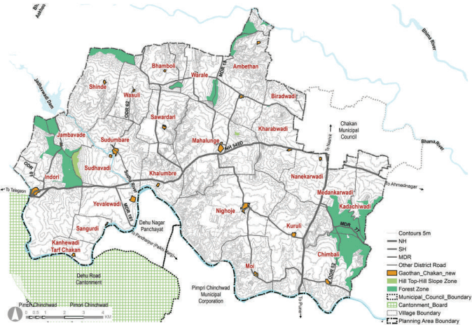
Chakan Growth Centre’s terrain is gradually sloping towards the South, where the Indrayani river is located. The Indrayani River has tributaries, out of which Sudha river is the major one.Approximately 6% area of the growth centre is under Forest, majorly found in Jambavade, Indori, Kadachiwadi, Medankarwadi, Kuruli and Chimbali. . Degradation of the Indrayani River is a crucial environmental issue for the Chakan Growth Centre.
Chapter 20: Growth Centre: Chakan
Figure 20.1: Location and Physiography
Regional Plan 1997 Analysis
Chakan Growth Centre area was part of Sector M, Sector Maval and Sector Pune District in RP 1997. Due to existing junction of Pune - Nashik National Highway and Talegaon-Ahmedpur ( Via Shrigonda) National Highway and in proximity to Pimpri – Chinchwad - Bhosari industrial area, was proposed to be developed as a “Industrial Township”as per Sanctioned Regional Plan Pune 1997. A township of 1 lakh population was planned for the year 2011 with 125 pph density.
Industry related proposals –
MIDC proposed along Pune- Nashik highway in villages Kuruli and Nighoje.
Industial zone proposed along Chakan – Ahmedpur national highway in Kharabwadi, Mhalunge, Sudumabre and Ambethan village.
Proposal of Industrial exhibition centre at Moshi, which is currently included in PCMC.
Transportation related proposals –
A diversion of 36 m. wide road on Southern side of existing Chakan – Talegaon - Shikrapur road,
45 m. wide dn – Shikrapur road with 12 m. wide service road.
Figure 20.2: RP 1997 Zoning Map
Table 20.1RP 1997 Area Statement
Land use category
Area (ha)
Proportion of Total Developed Area (%)
Proportion of Total Area (%)
Residential
680.29
21.89%
4.02%
Gaothan
91.40
2.94%
0.54%
Industrial
1238.46
39.86%
7.32%
MIDC
512.53
16.50%
3.03%
Public Utility
13.69
0.44%
0.08%
Transportation
570.69
18.37%
3.38%
Total Developed Area
3107.07
100 %
18.38%
Agriculture
10786.82
63.79%
Afforestation
1864.96
5.44%
Forest
919.55
11.03%
Water bodies
230.54
1.36%
Total Undeveloped Area
13802
81.62%
Total Area
16908.93
100%
Chapter 20: Growth Centre: Chakan
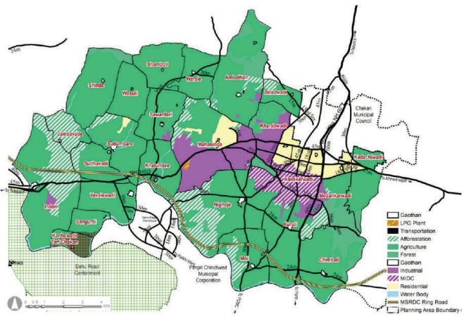
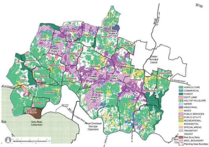
Chakan has grown into a leading industrial hub in recent years. However, most of the Growth Centre, is under agriculture (36 %) with 8% of the land is under natural features such as forest and water bodies. MIDC area is considered for Industrial use accounts for 6% .covering 1018.79 Ha. Residential developments cover 2% of the total area and are mainly around Chakan Municipal Council and NH-60.
Noticeable residential developments has seen in Mahalunge, Ambethan, Yevalewadi and Dehu. Compared to the developed land (53%) and a high share of industrial land use (6%), areas under roads in Chakan is just about 2.7%. It indicates the inadequacy of transport infrastructure in the area.
Existing public facilities like Siddhant Management and Engineering Institute, Tolani Institute, proposed campus for IIIT Pune (Indori) are major landmarks of the Growth Centre.
20.3Proposed Role and Strategies
Proposed Role
Chakan is positioned as a “Regional Centre and Automobile Hub,” and the key reasons for this are as follow:
Automobile hub to leverage upon following assets:
Established automobile manufacturing environment at Chakan MIDC and industrial ancillary units
Planned Chakan MIDC Phase-5
Presence of leading automotive research institute (ARAI) and its centre of excellence for Green Mobility
Two National Highways, the proposed Ring Road, Metro Line and its offshoot line, Pune-Nashik High-Speed Railway and Crescent Railway Line.
A Regional and Buisness Centre to fill the gap as below:
Supporting regional level amenities for urban and rural population envisioned in the north of the region, which is situated far from CBD at PCMC.
Complimenting requirements of an industrial hub for supporting business, financial, meetings and conventions.
Leveraging on proposed PCMC-Chakan Metro Line and its offshoot to promote a new Central Business District as a consolidated commercial node at the heart of Chakan Growth Center.
Leveraging upon the above, the proposed Automobile hub would open up a new commercial zone (293.70 ha) at various locations around existing and proposed MIDC estates to host Automotive- Electric Mobility, AI and Robotics, and High Tech Engineering industries.
Chapter 20: Growth Centre: Chakan
Table 20.3Population Projections
Village
2011
2018
2031
2041
Ambethan
4,444
6,256
10,432
14,732
Bhamboli
913
1,762
2,267
2,419
Biradvadi
1,728
2,053
2,516
2,859
Chimbali
5,714
8,526
14,123
19,676
Induri
10,448
14,491
24,700
35,414
Jambavade
784
872
978
1,058
Kadachiwadi
2,946
4,934
7,113
8,758
Kanhewadi Tarf Chakan
973
1,050
1,124
1,181
Khalumbre
2,908
4,232
7,505
10,947
Kharabwadi (CT)
9,200
13,515
23,983
34,629
Kuruli
8,199
11,531
18,027
24,221
Mahalunge
9,687
21,340
37,065
50,526
Medankarwadi (CT)
12,576
25,408
48,240
70,078
Moi
2,740
3,578
5,263
6,975
Nanekarwadi (CT)
12,654
24,103
42,065
58,109
Nighoje
5,326
8,269
13,308
18,046
Sangurdi
1,189
1,294
1,404
1,488
Savardari
1,228
1,376
1,560
1,698
Shinde
1,749
2,163
2,550
2,783
Sudhavadi
1,026
1,179
1,384
1,537
Sudumbare
3,288
3,776
4,429
4,915
Varale
762
2,452
3,281
3,396
Wasuli
846
918
993
1,050
Yelwadi
3,044
3,636
4,253
4,658
Total
1,04,372
1,68,715
2,78,563
3,81,153
The projected resident workforce based on the projected population through the URGD method is 2,01,831. Considering the proposed economic activities of all the growth centres, employment distribution was proposed
based on the envisaged sectoral split for that Growth Centres. Accordingly, the employment to be generated for the Growth Centre for the year 2041 is estimated to be 2,74,401. The proposed residential density is about 125 PPH (12,500 persons/sq km).
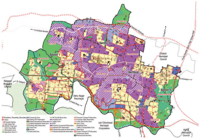
For the planning of public facilities distribution, Chakan Growth Center is divided into five sectors. The boundaries of this planning division are shown on the Proposed Zoning Map. The projected sector-wise population statement is in Table 20.3.
Table 20.4Projected Population - Sectors
Sector
2011
2018
2031
2041
Sector 1
16,621
32,101
53,294
71,513
Sector 2
28,396
36,749
53,147
69,148
Sector 3
21,979
31,904
50,721
68,918
Sector 4
15,522
30,342
55,353
78,836
Sector 5
21,854
37,618
66,048
92,738
Total
1,04,372
1,68,714
2,78,563
3,81,153
The proposed zoning would guide and determine the optimal and efficient land use for the next 20 years. The proposed zoning plan is an output of existing land use and physical conditions analysis, understanding of most pressing issues of the Growth Center, local knowledge of the place and deployment of five planning goals and allied physical planning strategies. The proposed zoning area statement is presented in Table 20.4.
Figure 20.4: Proposed Zoning Map
Chapter 20: Growth Centre: Chakan
Table 20.5Proposed Zoning Area Statement
Land use category
Area (Ha.) P Dreovpeol
rtion of Total Proporti oped Area (%) (%)
on of Total Area
Residential
4366.75
33.90%
25.83%
Gaothan
75.60
0.59%
0.45%
Commercial
290.67
2.26%
1.72%
Industrial
3250.92
25.24%
19.23%
MIDC
2889.60
22.43%
17.09%
Logistic
466.05
3.62%
2.76%
Public and semi public
199.55
1.55%
1.18%
Recreation
133.46
1.04%
0.79%
Public Utility
32
0.25%
0.19%
Transportation
1175.69
9.13%
6.95%
Total Developed Area
12880.28
100%
76.17%
Agriculture
2113.58
12.50%
Afforestation
123.88
0.73%
Water bodies
392.28
2.32%
Hilltop Hill Slope
35.70
0.21%
Quarry
74.18
0.44%
Forest
976.26
5.77%
Green Belt
312.81
1.85%
Total Un-developed Area
4028.69
23.83%
Total Area
16908.97
100%
Translating Goals into the Plan
Proposed zoning ensures that the sectoral development goals are clearly conveyed through it. Proposed sectoral goals and their corresponding physical planning strategies are mentioned in Table 20.5.
Table 20.6Goals and Physical Planning Strategies
Goals
Development Sector Addressed
Physical Planning Strategies
Prudent
Employment and housing
Work- Live Hubs
Convenient
Roads and mass transport
Movement Lattice
Resilient
Environment protection
Green- Blue connectors
Efficient
Infrastructure and utilities
Decentralized resource management
Self- sufficient
Social facilities
Walkable Neighbourhoods
For Chakan Growth Center, the Work-Live concept is applied by:
Designating residential zones within 500 m around industrial, logistics and commercial zones to minimize work-related trips for at least 30% of the resident workforce.
Allocating industrial, logistics, and commercial zones along the proposed mass transit corridors to reduce travel time for commuting workforce from other Growth Centers.
Proposing integrated town planning schemes.
Out of the total proposed industrial zone over 18660 Ha., industrial use over 5600 Ha. is envisaged in Chakan Growth Centre, both based on projected employment and 50 workers/ha density.
Chakan Growth Centres would anchor the future growth of the Study Area’s industrial sector with a new employment generation estimated to be 2,74,401 .Considering the existing industrial development scenario, strategic infrastructure proposals within the Growth Centre and the planning intent of RP 1997, industrial zone over an area of 3223.23 ha. is proposed.. It is arrived at by considering worker density of 50 workers/ha and increasing it by 30% to account for roads (15%), open spaces (10%) and amenity (5%).
The planning intent is to complement the expansion of MIDC estates towards their Northern side and optimize the proposed industrial zone from RP 1997. Industrial zoning at South and West of Chakan Municipal Council is increased to consolidate sparsely distributed existing industrial activities along the secondary arterial roads. A new industrial area is designated at the intersection of NH-60 and PMRDA Ring Road to ensure smooth logistics for industrial activities. Planned industrial development can be achieved through proposed industrial town planning scheme.
The total logistic land use requirement of the Study Area is estimated to be 2020 Ha. considering projected demographics and area requirement of 55 sqm built-up area per person. 400 Ha. of this estimated area is anticipated in Chakan Growth Centre. However, considering the proposed role of the GC, the prevailing trend of warehousing and supplementary industries and the proposed strategic infrastructure projects, logistic use is proposed over 466.05 Ha.
Logistic zone is proposed with an intention to develop a consolidated logistics park at a strategic location to avoid negative impact on surroundings and gain efficiency and economies of scale for logistics operations. Accordingly, the logistics zone is proposed a) Adjoining to cresent railway station at Bhamoli. b) Along the cresent railway and adjoining to MIDC at village Ambethan ; c) Along PMRDA ring road and adjoining to MIDC at Nighoje..
Land requirement for the residential zone is estimated based on a net residential density of 125 PPH. Further, 45% add-on is considered to account for amenity (15%), open spaces (10%) and roads (20%). Accordingly, the total gross area required for the projected GC population of 3,81,153 by 2041 is estimated to be 4420 Ha..
The total population of ITP in the Growth Centre is 10,500, while the projected population for the rest of the Growth Centre area is 3,81,153. Accordingly, the total gross area required for the total projected GC population of 3,81,153, is estimated to be 4420 Ha.
Considering the projected population, net residential density, proposed role and existing growth trends within the Growth Centre 4401.77 Ha. of gross residential zone is proposed.
As per the Work Live hub concept, consolidated residential zoning is proposed in the Growth Centre. Existing Gaothans at Yewalewadi, Indori, Khalumbe, Sudumbare, Mahalunge, Nighoje, Kuruli, Moi, Chimbali, Kadachiwadi, Nanekarwadi are considered as social nuclei. Residential zoning is proposed around them to drive their future growth. Proposed residential zoning at Yewalewadi, Indori, Khalumbe, Sudumbare, Nighoje, Kuruli, Moi, and Chimbali would enjoy direct access to the proposed Metro projects. Total 4 Town Planning Schemes are proposed
Chapter 20: Growth Centre: Chakan
at Ambethan, Biradwadi, Kharabwadi( TPS– 1) , Nighoje , Moi (TPS– 2) , Yewaleadi, Sangurdi, Indori (TPS-3),Sudhavadi, Khalumbare (TPS -4).
Land requirement for the commercial zone is estimated based on URDPFI guidelines, i.e. 0.6 ha per 1,000 population. Add on of 30% is considered to account for roads (15%), open spaces (10%) and amenities (5%). Accordingly, the total commercial zone requirement for the Study Area is estimated to be 297 Ha. 290.67 Ha. from this area is proposed in the Growth Centre such that equitable distribution of commercial activities is facilitated.
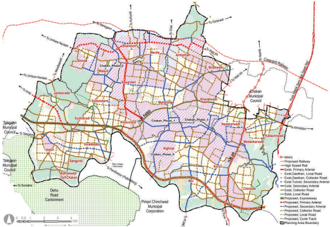
A parallel system of secondary arterial roads (30-45 m wide road system) to NH60 and NH548D is proposed to alleviate the congestion and to disconnect from local traffic.
Metro line is proposed along the NH-60 to connect to Chakan Municipal Council and PCMC. A separate Metro line is proposed that would branch off from the proposed Metro station at Chimbali until Bhamboli and follows the proposed road alignment passing through the MIDC estate.
As per tirthkshera Aarakhada , Dehu 30m wide road has been proposed , in DDP, 30 m. wide road has proposed as it is from Yevalewadi for Palakhi Marg.
All proposed roads are to be designated with at least 3m wide footpath on either side of the road, as the ‘pedestrian right of way’ and ‘hawker-free zone.’
Figure 20.5: Proposed Transport Network Map
Table 20.7Proposed Transport Network Statement
Road Category
Road names/ROWs
Proposed ROWs
Authority
Total Length (km)
Total road development cost(INR Cr)
Primary
NH60
60
NHAI
7.6
NH 548 D
60
NHAI
20
Tertiary
MDR 17
30
PWD
10.7
MDR 18
30
PWD
4
MDR 20
24
PWD
8
MDR 77
30
PWD
13.79
MDR 103
24
PWD
4.19
MDR 161
30
PWD
2.4
ODR 52
18
ZP
3.22
ODR 56
18
ZP
0.8
ODR 57
24
ZP
3
ODR 59
24
ZP
6.8
ODR 61
18
ZP
2.3
ODR 62
30
ZP
4.3
Local
VR (Total)
45
ZP
38.84
Primary
M RoSaRdDC Ring 11060
MSRDC PMRDA
20.34.5
-62
Secondary
303645
PMRDA PMRDA PMRDA
29.363.807.84
230.8090.76137.67
Tertiary
241815
PMRDA PMRDA PMRDA
18.4793110
100.11474.37519.71
Local
12
PMRDA
9.96
293.37
Total Road Length
427.17
1908.79
“Resilient” goal aims to strengthen the inbuilt capacity of Growth Centres to sustain in adverse climatic conditions such as flooding, landslide, air pollution and climate change by protecting environmental features and land susceptible to such threats. The goal also aims to make these features accessible for passive recreation to cover the existing deficit of recreational spaces. It translated into the plan employing the Green- Blue Connector Strategy. ‘Green’ refers to the protected forests and slopes; ‘Blue’ refers to the protected water bodies; and ‘Connector’ refers to the proposed avenues and streams/ canals. Avenue is conceived as a tree-lined road, with NMT provision, linking the Green and Blue features.
All lands with slope >1:5 are designated as Hilltop hill slope zone and shall be kept free of development.
The existing forest areas at Indori,Sudhavadi,Jambavade, Shinde, Ambethan, Warale, and Medankarwadi,Chimbali, Kadachiwadiare designated as protected areas.
Green Belt to be reserved between the river bank up to the blue line for Indrayani River and Sudha River.
Riverfront development is proposed along Indrayani River at Sangurdi, Nighoje, Yewalewadi of 44.11 Ha. area for beautification of river.
These protected Green-Blue features are recommended to be connected by a 30-45m wide secondary arterial road that would be upgraded as a tree-lined avenue by developing NMT corridors (>3 m each) on both sides of roads and segregated from footpaths.
Green lungs are proposed within 500 m walkable distance covering an area of 445.70 ha. These green lungs
Chapter 20: Growth Centre: Chakan
include active and passive recreational spaces. The total active recreational space works out to be 56.54 ha that include playgrounds, sport complex, stadium and multi-purpose ground. And the total passive recreational space works out to be 389.15 ha that include gardens, town park/ regional park, bio diversity park and green belt.
A water treatment plant is proposed at Biradwadi over 3.39 Ha..
2 solid waste management sites of 7.1 Ha. are proposed, one is at Biradwadi and Second one is at Indori to cater whole planning area..
4 Sewage treatment plant (3.33 Ha.) are proposed.
Effluent treatment plant (1.1 Ha) is proposed at Nighoje.
Table 20.8Proposed Infrastructure Demand
Infrastructure System
Demand (2041)
Unit
Required Area (Ha.)
Utility Sites
Total Area
Water Supply
27.61
MLD
0.48
1 WTP
3.3 ha
Sewerage
27.44
MLD
4.12
5STPs
3.4 ha
Solid Waste
114.35
Tones/day
5
2 SWM
7.1 ha
This goal is set to increase the livability index of the Growth Centre. To do that, amenities are proposed within 500 m distance, leveraging the concept of Walkable Neighbourhoods. The concept entails providing basic infrastructure and services for education, health, sports, and recreation within the neighbourhood to have easy access to them by foot.
Amenity provision is made for the projected population by 2031 (2,78,563 people)
Neighbourhood level amenities are located within a 500 m- 1000m. radius from residential zones and are connected by collector/local roads to improve their accessibility from other neighbourhoods.
Chakan is an established urban centre in the Growth Centre. Thus the concentration of amenities is observed here.
Education: PS and SS are clubbed and provided at newly opened up residential zone; Wherever possible, expansion of existing ZP schools is proposed with proper road access; Total 4 primary schools and 4 Primary + Secondary schools are provided. At Sudumbre and Khalumbre one medical college along with hospital of 17 Ha. area is provided.
Health: Total 12 health Centres and 1 hospital is proposed considering walking radius within neighbourhoods. At Sudumbare one infectious disease hospital is proposed. One trauma care centre is proposed along NH 548 D at Yevalewadi. At Sudumbre and Khalumbre one medical college along with hospital of 17 Ha. area is provided.
Socio-Cultural: Total 13 community halls , 3 culture centres and one spiritual centre is proposed at Sudhavadi as Sudhavadi is near to Bhandara hill.
Open Space: Considering spatial distribution, total 29 Garden, 25 playgrounds are proposed.2 sports complex, one at Mhalunge and another at Sudumbare. One sport university has been proposed at Indori and one Stadium at Sangurdi. Also 2 town parks are proposed at town level. At Kanhewadi Tarf Chakan, one exhibition cum fair ground and one multipurpose ground at Sudhavadi is proposed. At Yewalewadi, Sangurdi and Nighoje, river front development is proposed along Indrayani River for beutification of river.
Commercial: Shopping Centre is provided at existing commercial nodes or near existing settlements or on available amenity spaces. Total 12 shopping centres are proposed considering spatial distribution. As propsed role of Chakan is Automobile hub and Regional Centre , 2 Regional Centres are proposed at Mhalunge and Sudumabre and one Business centre is proposed near Nighoje.
Residential : At Kanhewadi Tarf Chakan , 1.96 Ha. is allotted to housing for dishouse. Aproximately 32.70 Ha. area is proposed under public housing.
Transportation : At Kadachiwadi, high speed railway station has been proposed. Two multimodal hubs, two bus depots , one parking and truck terminus has been proposed.
Civic facilities requested by various government authorities: Total 14 civic facilities proposed with consideration of request by various government authorities. APMC market, hostel, warehouse, Indori upbazar, police station, post office and government rest house has been proposed.
Table 20.9Summary of Land Ownership of Proposed Amenities
Land Ownership
No of Amenity
Total Area (Ha)
Government Land
77
238.9
Private Land
73
98.39
Amenity Space
9
3.55
Trust
3
1.90
Mix land( eg. Govt.+pvt, AS+Pvt)
7
59.06
Total
169
401.82
Implementation Strategy for the Proposed Reservations
Town Planning Scheme: PMRDA envisages implementing the Development Plan proposals by enabling the provision of Town Planning Schemes, which will considerably reduce liability towards the direct cost of acquisition of land required for social and physical infrastructure. Total 4 Town Planning Schemes are proposed at Ambethan, Biradwadi, Kharabwadi ( TPS – 1) , Nighoje , Moi (TPS – 2) , Yewaleadi, Sangurdi, Indori (TPS -3), Sudhavadi, Khalumbare (TPS -4)
The reservations proposed to be developed using the TPS mechanism are as follows:
a. Strategic Projects : Business centre, Effluent Treatment plant,, Government office, Regional centre, sports complex
b. Amenities: Primary and secondary schools, playgrounds, APMC market, community hall, culture centre, Fire Stations, Gardens, health care centre , trauma care centre, infectious disease hospital, medical college and hospital, multipurpose ground, public housing, , riverfront development, shopping centre.
The other proposals/reservations of the Development Plan are proposed to be acquired and developed through the mechanism of Accommodation of Reservation and Transfer of Development Rights (TDR) policy. It is estimated that all proposed roads and 50% of the public reservations will be acquired through TDR/FSI/ AR.
The remaining reservations will be acquired under the provision of the Land Acquisition Act by paying monetary compensation.
Chapter 20: Growth Centre: Chakan
Figure 20.6: Strategic Projects
20.4Proposed Reservation Statement, Costing and Phasing
Table 20.10Proposed Reservation Statement
Sr.
Purpose of Reser-vation
Planning Standard
Total Require-ment
Existing/Available
Proposed reservations
Total Reser-vations
Area
Min. unit required
No. of sites
Area in Ha
No. of sites
Area in Ha
No. of Sites
Area in Ha
No. of sites
Area in Ha
Neighbourhood Level
1
Primary School I - V
0.4 ha including playground.
1/500 students
56
22.29
61
12.21
9
8.54
70
20.15
1/5000 population
2
Secondary VI - XII
1 Ha. / site (0.6 ha for play ground and 0.4 ha for building)
1/1000 students
28
27.86
35
8.60
5
7.17
40
16.08
1/10000 population
3
Healthcare Centre
0.08 - 0.12 Ha
1HC / 15,000 population
19
2.23
16
1.83
12
2.38
28
4.21
4
Community Hall
0.2 ha/ site
1 /15,000 population
19
3.72
0
0
13
3.21
13
3.21
5
Garden
1 Ha
1/15000 population
19
18.58
1
0.50
29
22.66
29
22.44
6
Playground
1.5Ha
1/15,000 population
19
27.87
0
0
25
28.40
25
28.40
7
Shopping Centre
0.3- 0.45 Ha
1/15,000 population
19
8.55
0
0
12
6.58
12
6.58
Town Level
8
College
5 Ha
1000 - 1500 students
2
10.00
9
60.18
0
0.00
9
60.18
1/1.25 lakh population
9
Hospital/Trauma Care Centre
Cat A = Area- 3.70 Ha
1/100,000 population
3
3.00
0
0
2
4.23
2
4.23
200 beds, Cat B = Area =1 Ha., 80 beds
10
Public Housing
-
-
1
9.60
0
0
9
32.70
9
32.70
11
Housing for Dishouse
-
-
0
0
0
0
1
1.96
1
1.96
12
Cultural Centre/ Social Welfare Centre/ Socio-Cultural Centre
0.6-1 Ha.
1/ 1Lakh
0
0
0
0
3
3.00
3
1.86
13
Town Park
3- 5 Ha.
1 / 1 lakh
3
9.00
0
0
2
9.39
2
9.39
14
Sports complex
3- 5 Ha.
1 / 1 lakh
3
9.00
0
0
2
5.21
2
5.21
15
Multipurpose Ground
As per land availability
0
0
0
0
1
3.00
1
3.00
Chapter 20: Growth Centre: Chakan
Sr.
Purpose of Reservation
Planning Standard
Planning Standard
Total Requirement
Total Requirement
Existing/ Available
Existing/ Available
Proposed reservations
Proposed reservations
Total Reser- vations
Total Reser- vations
Sr.
Purpose of Reservation
Area
Min. unit required
No. of sites
Area in Ha
No. of sites
Area in Ha
No. of Sites
Area in Ha
No. of sites
Area in Ha
16
Fire Brigade station
0.4 Ha.
As per require- ment of Fire department of PMRDA. 1 Fire station / growth centre
1
0.40
0
0
2
1.16
2
1.16
17
Burial ground
4 Ha.
1 site/ 5 lakh,
1
2.23
1
0.92
1
1.78
2
2.6
18
Cremation ground
2.5 Ha
1 site/ 5 lakh,
1
1.39
15
2.65
1
0.62
16
3.26
19
Parking
As per land availability
As per land availability
0
0
0
0
1
0.30
1
0.30
20
Solid Waste Management Site
5 Ha . (As per land availability)
1 site per growth centre
1
5.00
0
0
2
7.15
2
7.15
21
Sewerage treat- ment plant
80% of water supply may be expected to reach the sewers
Land area requirement is as per URDPFI i.e. For activat- ed Sludge Process (ASP)-0.15 Ha/ MLD
1
4.12
0
0
5
3.34
5
3.34
22
Water works (Water treatment Plant, tanks & pipes)
Land area requirement is as per URDPFI i.e. 1) 5MLD- 0.10 Ha 2) 10MLD- 0.19Ha 3) 50MLD- 0.93 Ha 4) 100MLD- 1.87Ha 5) 200MLD- 3.73Ha 6) 500MLD- 9.34Ha
Water require- ment of PMR is 72 lpcd as per Report 'Integrated Master Plan Of Water Supply, Sewerage, Storm Water and Solid Waste Man- agement in the PMR'. It is distributed to each Growth center.
1
0.48
1
Table 20.11Cost and Acquisition Statement for Proposed Reservations
Cultural Centre/Social Welfare Centre/ Socio-Cultural Centre/ Community and cultural centre
9, 29, 77
14
28
Sports University
12
29
Industrial Research & Training Centre
75
30
Hospital & Medical College
53
31
Spiritual Centre
25
32
Exhibition cum Fair Ground
4
33
River Front Develop-ment
44, 168
34
Stadium
7
35
Business Centre
164
Chapter 20: Growth Centre: Chakan
Sr. No.
Purpose of Reservation
Phase I (Reser-vation No)
Phase II (Res-ervation No)
Phase III (Reservation No)
Phase IV (Res-ervation No)
Phase V (Reser-vation No)
36
Regional Centre
56, 80
37
Multimodal Hub
51, 151
1
38
High speed Railway Station
140
39
APMC Market, Khed
31
40
Hostel
87
41
Indori Upbazar
30
42
Infectious Disease Hospital
65
44
Parking
138
45
Post Office
37
46
Truck Terminus
70
47
Warehouse
103
48
Rest House
165
Total Cost of development of Reservations of UGC : Chakan
GC
Total Acquisition cost of Reservations ( in Rs.CR.)
Total Construction cost of Reservations ( in Rs.CR.)
Total Cost of development of Reservations( in Rs.CR.)
Road construction cost
Total Development Cost
Reservation on Amenity Space/TP scheme/Government (A)
0.00
4057.92
4057.92
1908.57
6703.99
Reservations on Private land
133.00
1341.99
1474.99
50% of the total cost of reservations on private land with an assumption that 50% of reservations will be developed through TDR/AR & In-situ FSI (B)
66.50
671.00
737.50
Total Cost (A+B)
66.50
4728.92
4795.42
Chapter 21: Growth Centre: Alandi
Figure 20.3: Existing Land Use Map
Table 20.2Existing Land Use Area Statement
Land use category
Area (ha)
Proportion of Total Devel-oped Area (%)
Proportion of Total Area (%)
Residential
275.75
11%
1.6%
Gaothan
84.89
3%
0.5%
Commercial
279.89
11%
1.7%
Industrial
1018.79
39%
6%
Public semi Public
346.22
13%
2%
Transport
453.72
18%
2.7%
Mixed Use
16.40
1%
0.1%
Public Utilities
22.92
1%
0.1%
Public services
84.47
3%
0.5%
Total Developed Area
2583.05
100%
15.3%
Agriculture
6168.90
36.5%
Forest
945.34
5.6%
Hilltop Hill slope
333.83
2.0%
Special areas
88.24
0.5%
Recreational
43.01
0.3%
Water Body
366.92
2.2%
Vacant land
6379.13
37.7%
Total Non - Developed Area
14325.38
84.7%
Total
16908.44
100%
In terms of implementation of RP1997, the percentage of the existing residential area is less as compared to approved regional plan; it is not fully utilized due to lack of supporting amenities and supporting land uses such as commercial, PSPs, and utilities which collectively measure about 4.61%.
Weak enforcement of RP development regulations can be seen in the form of unauthorized developments observed in agricultural areas along the roads.