Shikrapur Growth Centre is envisioned as a Logistics and Industrial Hub, leveraging its strategic location along the Aurangabad-Chakan-JNPT industrial corridor (NH-548D) and existing industrial cluster in Sanaswadi. Pune-Ahmednagar Highway (NH-753F) and the proposed Crescent railway line for cargo use will act as a catalyst to realize the proposed economic positioning. Its proximity to Wagholi and PMC as well as mass connectivity through the proposed Metro route (Ramwadi-Wagholi-Shikrapur) will further add to the ease of commute.
Promote logistic and warehousing activities by consolidating cluster development, leveraging upon existing high demand along Pune-Ahmednagar Road and capitalising on the Crescent Railway and Metro corridor (Ramwadi-Wagholi-Shikrapur)
Promote Work-Live hub concept by increasing residential development adjacent to existing industrial activities
Develop bypasses to primary roads for avoiding congestion due to logistic activities at Sanaswadi
Develop a grid network of secondary and tertiary roads for a smooth movement within the Growth Centre
Develop tourism activity along the Bhima River in proximity to Tulapur
Establish green-blue links by connecting forest and green belts of Bhima River, Velu River, Chaskaman left bank canal and existing streams with green avenues
Promote self-sufficient town by proposing required amenities and utilities for the projected population
Crescent Railway and Station at Vadhu Bk (18.12 ha)
Logistic Hub at Vadu Bk (99.6 ha)
Metro line (Ramwadi-Wagholi-Shikrapur) and Metro Depot at Vadu Bk (17.15 ha)
Integrated development of Town Centre (15.37 ha) and Multimodal Hub at Vadu Bk (9.63 ha)
Town Planning Scheme themed as a logistic park at Vadu Bk (295 ha)
Spiritual Tourism Hub at Apti (23.87 ha)
Cultural Centre (1.51 ha) and Sports Complex (2.16 ha) at Shikrapur and Talegaon Dhamdhere, respectively
Public housing at Wadhu Bk, Sanaswadi and Talegaon Dhamdhere
30m bypass to NH-753F and 60m bypass to NH-548D
30.2Existing Situation Analysis
Shikrapur Growth Centre comprises six villages, namely Apti, Vadhu Bk, Koregaon Bhima, Sanaswadi, Shikrapur and Talegaon Dhamdhere. All these villages fall under Shirur taluka. The total area of the Growth Centre is 90.92 sq km. According to Census 2011, the total GC population was 68,504 in 2011, while the estimated population and resident workforce for 2018 are 43,036 and, respectively.
Key strength of Shikrapur Growth Centre is strategically located along the Aurangabad-Chakan-JNPT industrial corridor, served by two national highways that underpin logistic development potential. RP 1997 recognized Sanaswadi as an industrial node that has successfully attracted multi product industrial SMEs and industrial giants such as Arcelor, Mittal Nippon, Oriental Rubber, and John Deere at Sanaswadi.
Shikrapur Growth Centre is located on the northeastern side of PMR along Pune-Ahmednagar Highway (NH-753F) within Shirur taluka. It is abutted by Wagholi Growth Centre (south-west) and Alandi Growth Centre (west), whereas rural areas surround it on the rest of the sides.
The approximate distance of the Shikrapur Growth Centre from PMC and PCMC is 28 km and 30 km. Shikrapur is situated at the crossroads of Ahmednagar Highway and the Major District road connecting Chakan and Talegaon Dhamdhere. NH-548D connects Shikrapur to Chakan and further to the Rural Growth Centre Nhavare. ODR-144 connecting Wadhu Bk to Talegaon Dhamdhere proves to be an important connection of the GC. Two major district roads, MDR-23 and MDR-51 and NH-548D, all meet at Shikrapur, creating a critical junction adjacent to Shikrapur gaothan, while ODR-158 and ODR-144 along with NH-548D, all converge at Talegaon Dhamdhere, creating a radial pattern.
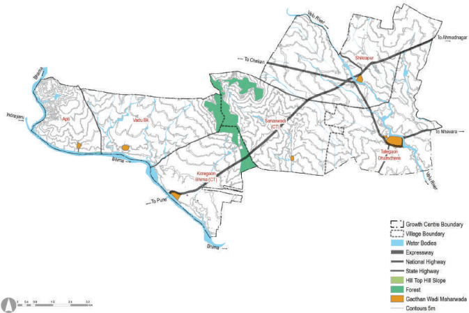
Shikrapur GC is located over the larger basin of River Bhima, where Bhima River forms the southern edge of the Growth centre. Vel River, a tributary of Bhima, passes through the Growth Centre. The area is located comparatively on flat terrain, with its terrain gradually sloping towards the south. Chas Kaman’s left bank canal also passes through the GC. The Forest area running in the north-south direction, located south of Sanaswadi, divides the Growth Centre area into two.
Figure 30.1: Location and Physiography
Chapter 30: Growth Centre: Shikrapu
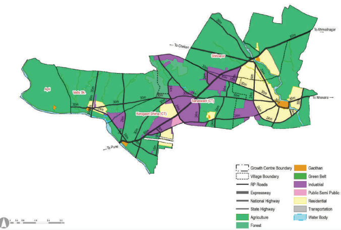
Shikrapur Growth Centre is a part of RP Sectors L. RP 1997 proposed a self-sufficient township for an estimated population of 145,000 by 2011 for the entire Sector, for which the majority of the proposed residential zone (1,038.22 ha) was assigned in Talegaon Dhamdhere, Koregaon Bhima and Sanaswadi. Industrial zone was proposed over 924 hectares at Sanaswadi, Koregaon Bhima, Talegaon Dhamdhere and Shikrapur. The Government forest land and hilly barren land in Sanaswadi, admeasuring about 232.66 ha, are shown in the Forest zone. Since commercial use was generally allowed within residential zoning, sporadic commercial developments are observed along major roads. The total area designated under the agriculture zone was 6,209 Ha.
In terms of the implementation of RP1997, the residential zone is not fully developed as planned. New residential pockets can be seen around Shikrapur. Industrial zones are located on either side of the Pune-Ahmednagar Highway around existing industrial units located in Koregaon Bhima, Sanaswadi and Shikrapur. Residential zoning proposed around Vel River have led to encroachment within flood lines, which need to be addressed by meticulous planning and development control regulations.
Figure 30.2: RP 1997 Zoning Map
Table 30.1RP 1997 Area Statement
Land use category
Area (ha)
Proportion of Total Developed Area(%)
Proportion of Total Area (%)
Residential
1038.22
44.93
11.42
Commercial
0
0.00
0.00
Industrial
924.12
39.99
10.16
Public and semi public
31.71
1.37
0.35
Public Utility
0.00
0.00
Transportation
316.62
13.70
3.48
Defense
0.00
0.00
Total Developed Area
2310.67
Agriculture
6211.59
91.56
68.29
Water bodies
249.68
2.75
2.75
Green Belt
90.27
1.33
0.99
Hill Top Hill Slope
0.00
0.00
Forest
232.66
3.43
2.56
Total Undeveloped Area
6781.92
100.00
Total Area
9094.87
Existing Land Use
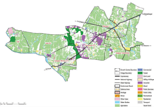
Agriculture use followed by industrial use dominates the existing land use in the Growth Centre. Sanaswadi is a major industrial cluster, whereas residential developments are concentrated in Talegaon Dhamdhere and Shikrapur. Scattered settlements are present around Koregaon Bhima and Sanaswadi.
Natural features constitute about 8% of the land, with a major portion occupied by forest and water bodies. Vacant land use is observed at Sanaswadi, where the majority of the industrial activity is prevalent. Residential land use merely covers about 2% of the total area, and supporting land uses such as commercial, PSPs, and utilities collectively measure about 3%.
Most public facilities such as schools, government offices and health facilities are concentrated in Koregaon Bhima and Shikrapur. KEM Hospital and Al Ameen College of Engineering and Management are notable landmarks in the Growth Centre, along with famous industries such as John Deer, Oriental Rubber and Arcelor.
Figure 30.3: Existing Land Use Map
Chapter 30: Growth Centre: Shikrapu
Table 30.2Existing Land Use Area Statement
Land use category
Area (ha) Poproepdo Artrieoa
n of Total Devel- Proporti (%) Area (%)
on of Total
Residential
194
16.78
2.14
Commercial
72.3
6.26
0.80
Industrial
403.24
34.89
4.45
Public and semi public
175.19
15.16
1.93
Garden, Playground and Recreation
33.44
2.89
0.37
Public Utility
20.72
1.79
0.23
Transportation
256.95
22.23
2.84
Defense
0
0.00
0.00
Total Developed Area
1155.84
Agriculture
4862.42
53.30
Water bodies
320.9
3.54
Vacant Land
2410.2
26.61
Forest
329.5
3.64
Hill Top Hill Slope
13.98
0.15
Total Undeveloped Area
7937
Total Area
9058.42
Traffic congestions along the NH-753 F with no bypass developed
The critical junction at Shikrapur gaothan
High-density development, especially at Shikrapur, with a lack of infrastructure provision
Narrow and unpaved roads leading to poor accessibility
Lack of amenities such as healthcare and social centres
Lack of recreational areas such as playgrounds and gardens
Absence of sewerage, stormwater drainage and solid waste management sites