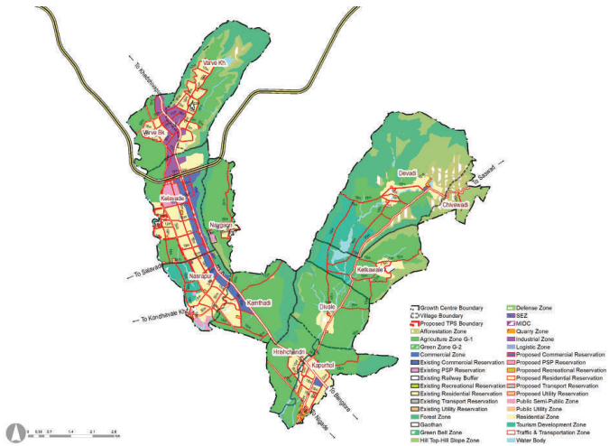
Nasrapur Growth Centre comprises of 12 villages from Bhor and PurandarTalukas as below:
-
Bhor taluka comprises of 9 villages namely, Varve Kh., Varve Bk., Kelavade, Naygaon, Kamthadi, Nasrapur, Harishchandri, Kapurhol and Divele.
-
Purandar taluka comprises of 3 villages, Ketkawale, Devadi and Chivhewadi. 2 villages out of total 12 falls under Western Ghat villages, namely, Ketkavale and Chivhewadi.
-
Area of the Growth Centre is about 5754.41 Ha. and it’s population was about 19,605, as per Census 2011.
Key strengths of the Growth Centre are established tourism nodes and its connectivity to Pune via Mumbai-Bangalore Highway (NH 48). Existing trend of well-planned low density residential enclaves and amusement parks and has potential to become hub for tourists, visiting salient forts with heritage tourism potential. Saswad Airport is made accessible by MSRDC Ring Road and SH 119.
Location & Connectivity
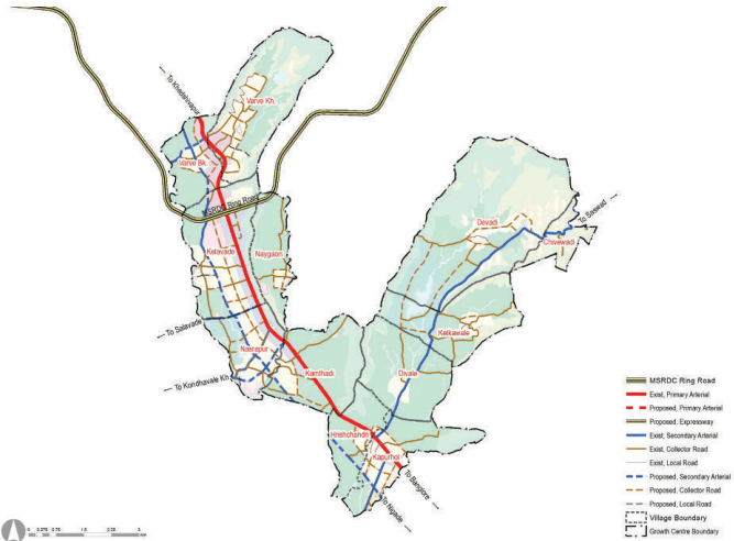
Nasrapur Growth Centre is located on the south of PMR Region along the Mumbai-Bangalore Highway (NH 48). It shares Northen boundary with KhedShivapur Growth Centre. It is connected to PMC to the north by Mumbai-Bangalore Highway (NH 48). It’s future connectivity is likely to be strengthened by widening of NH 48. Connectivity to, proposed Saswad Airport is strengthened by proposed MSRDC Ring Road and SH 119. Proximity to proposed Chatrapati Sambhaji Maharaj Airport near Saswad (approx.18 KM) and MSRDC 110M ring road (approx. 0.16 Km from boundary)has potential for extension of existing Industrial Cluster in the growth center. Devadi dam, PratiBalaji and Baneshwar temple is the main tourist attraction in Nasrapur Growth Centre and a well known Navsahyadri College of Engineering of Navsahyadri Education Society is in Naygaon village. The approximate distance of Nasrapur, from PMC and PCMC is 26 km and 51 km, respectively.
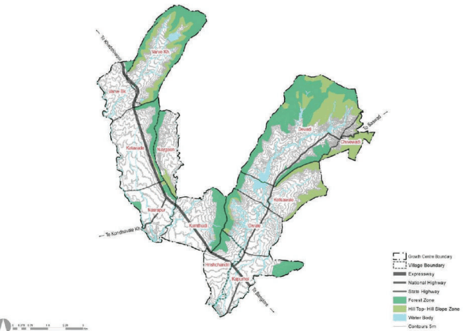
Terrain of Nasrapur is sloping towards south west with presence of hills on Northern and Eastern edge. Shivganga and Gunjavani rivers flow along western and southern boundary of the Growth Centre. Physiography of the area is greatly influenced by the presence of Sahyadri Hills.
Figure 34.1: Location & physiographic
Chapter 34: Growth Centre: Nasrapur
Regional Plan (RP) 1997 Analysis
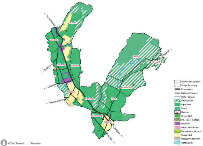
Nasrapur Growth Centre lies under Sector Q and Pune District of RP 1997. As per RP 1997, most of the area under Growth Centre was proposed to be agriculture, with four major residential nodes at Kapurvhol, Nasrapur , Varve Khurd and Kelavade villages and an industrial node at Kelavade. Small industrial parcel were also proposed along NH 48. Two bypasses were proposed to NH 48 in RP. In terms of implementation of RP1997, Industrial zone is mostly implemented and extended along NH 48. Residential area is witnessed, under-developed. 2081.73 ha of agriculture zone proposed in the Regional Plan dominates the Growth centre.
Figure 34.2: RP 1997 Zoning Map
| Land use category | Area (Ha) | Proportion of Total Devel-oped Area (%) | Proportion of Total Area (%) |
|---|---|---|---|
| Residential | 510.66 | 62% | 9% |
| Gaothan | 61.36 | 7% | 1% |
| Industrial | 79.31 | 10% | 1% |
| Transportation | 171.00 | 21% | 3% |
| Total Developed Area | 822.34 | 100% | 14% |
| Agriculture | 2081.73 | 36% | |
| Forest | 1083.75 | 19% | |
| Afforestation | 1657.91 | 29% | |
| Water bodies | 107.35 | 2% | |
| Total Undeveloped Area | 4930.75 | 86% | |
| Total Area | 5753.09 | 100% |
Existing Land Use
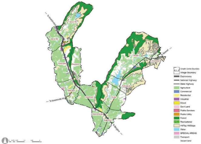
Agriculture (about 38.4%), Hill Top Hill Slope and forest (about 30.1%) and Vacant land (about 21%), dominates existing landuse composition of the Growth Centre. Sum of non-developable areas (about 92.8%) that includes agriculture, forest, hill top hill slope, special areas, recreational, and water bodies conveys environmental sensitivity of the planning area. Developed areas are about 7.2% of the total area of Growth Centre. It is dominated by residential and commercial zones.
Implementation of industrial zone proposed under RP 1997 can be seen at Kelavade. Commercial development is seen along NH 48 and in villages like Kelavade, Nasrapur and Harishchandri. Share of agricultural land is significant (38.4%) due to the presence of Shivganga and Gunjavani River and its topographic setting. Share of vacant land is also sizeable, since residential zone proposed in RP 1997 is is remained undeveloped due to lack of roads and social infrastructure. Compared to the existing demand and surge in growth of industries along NH 48, road and transport infrastructure is not adequate, has led to traffic congestion issues.
Figure 34.3: Existing land use map
Chapter 34: Growth Centre: Nasrapur
| Land use category | Area (Ha.) | Proportion of Total Developed Area (%) | Proportion of Total Area (%) |
|---|---|---|---|
| Residential | 113.59 | 28% | 2% |
| Gaothan | 38.43 | 9% | 0.7% |
| Commercial | 40.75 | 10% | 0.7% |
| Mixed | 8.24 | 2% | 0.1% |
| Industrial | 33.41 | 8% | 0.6% |
| Public - semi Public | 47.25 | 11% | 0.8% |
| Transport | 127.57 | 31% | 2.2% |
| Public Utilities | 2.72 | 1% | 0.05% |
| Total Developed Area | 411.97 | 100% | 7.2% |
| Agriculture | 2206.52 | 38.4% | |
| Forest | 1031.20 | 17.9% | |
| Hilltop Hillslope | 702.79 | 12.2% | |
| Special areas | 4.88 | 0.1% | |
| Recreational | 0.53 | 0.0% | |
| Water Body | 189.20 | 3.3% | |
| Vacant land | 1206.09 | 21 % | |
| Total Non-Developed Area | 5341.20 | 92.8% | |
| Total | 5753.17 | 100.0% |
Key Challenges:
-
Residential zone proposed in RP 1997 is not developed to its full potential.
-
Compared to the existing demand and surge in growth of industries along NH 48, road and transport infrastructure is not adequate, has led to traffic congestion.
-
Scattered development has seen surrounding to Gaothans.
-
Absence of sewerage, storm water drainage and solid waste management sites.