Wagholi Growth Center comes under Haveli taluka and comprises ten villages, namely, Awhalwadi, Loni-Kand, Kesnand, Bakori, Bhavadi, Taleranwadi, Perane, Phulgaon, Wadhu Kh and Wagholi. According to Census 2011, Wagholi Growth Centre population was 71,341 in 2011, and the estimated population for 2018 is 1,70,206 with 23,668 employed.
Wagholi Growth Centre enjoys great locational advantage with its proximity to adjoining PMC developments, Kharadi IT Park, Lohegaon Airport and Pune-Ahmednagar Highway (NH-753F), one of the busiest national highways in PMR. RP 1997 recognized Wagholi as a residential node which was successfully implemented with subsequent planned layout developments.
Wagholi Growth centre is located on the northeastern side of Pune Municipal Corporation along the Pune-Ahmednagar Highway (NH 753 F) within Haveli taluka. It is surrounded by Alandi Growth Centre on the northwestern side, Loni Kalbhor on the south side, PMC area on the south-western edge and Shikrapur Growth Centre on the northeastern front.
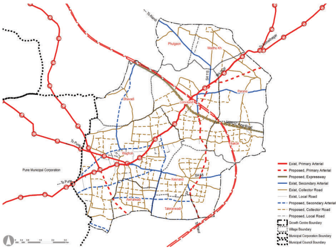
Wagholi Growth Center is abutting the PMC boundary, and it is 21 Km from PCMC. It extends almost 3.5 km on both sides of the NH 753F. SH-115 and NH 548DD connect Wagholi Growth Centre to Markal on north and Solapur Highway on south via Lonikand, Kesnad and Theur. NH 548DD further connects to Vadki and Uruli Devachi. Thus it connects the industrial development of Markal, Lonikand, Kunjirwadi and Vadki, providing an alternative to the PMRDA Ring Road. SH-68 provides fast connectivity to Lohegaon Airport, thus increasing opportunity for the hospitality industry and IT segment.
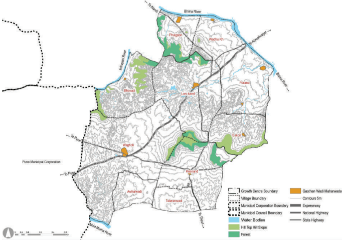
The northwestern part of the area is covered by quarry activity, creating a distinct edge between Alandi Growth Centre and Wagholi Growth Centre. Some of the northern part of the Growth Centre is under the forest zone, whereas the central-eastern edge has slopes. Wagholi Growth Center touches three rivers such as Indrayani River north-west side, the Bhima River north-east side and the Mula-Mutha River on its south-west side. Almost 33% of the land is under agricultural use. 337.43 ha of forest land is present in the northern edge of Kesnand and Lonikand villages and the southern edge of Phulgaon
Chapter 22: Growth Centre: Wagholi
Figure 22.1: Location and Physiography
Regional Plan 1997 Analysis
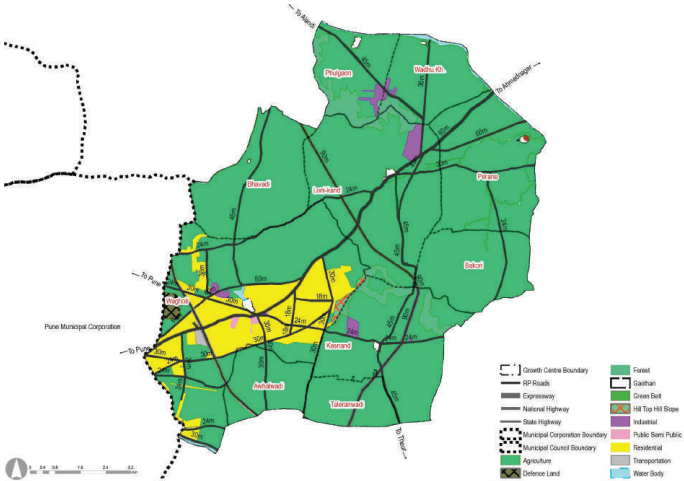
Wagholi Growth Centre includes part of RP 1997 Sectors such as Sector H and Sector PMR. The main concept of Sector H was to propose a residential zone, serving industrial nodes of Koregaon Bhima-Sanaswadi and MIDC’s at Vadgaon Sheri and Kharadi. Thus in the proposed boundary of the Growth Centre, the majority of Residential development is observed between the two bypasses proposed for Ahmednagar Road (NH 753 F) within the Regional Plan. The entire proposed residential zone was implemented and further spilled in Wagholi, Awhalwadi villages. Thus the residential trend is observed in this Centre.
Industrial zone proposed at Lonikand over 45 ha is observed to have been realised. This industrial area developed into a number of small scale units located along the NH 753F. The agriculture zone proposed over 8,745.46 ha in the Regional Plan 1997 dominates the Growth Centre.
Figure 22.2: RP 1997 Zoning Map
Table 22.1Regional Plan Land Use Area Statement
Land use category
Area (ha)
Proportion of Total Devel-oped Area (%)
Proportion of Total Area (%)
Residential
1081.81
60.6
9.79
Commercial
0
0.0
0.00
Industrial
113.4
6.3
1.03
Public and Semi public
16.93
0.9
0.15
Public Utility
0
0.0
0.00
Transportation
525.54
29.4
4.76
Defense
48.85
2.7
0.44
Total Developed Area
1786.53
Agriculture
8777.82
79.17
Water bodies
144.2
1.31
Hill Top Hill Slope
27.76
0.25
Forest
370.16
3.35
Total Undeveloped Area
9259.82
Total Area
1178.8
Chapter 22: Growth Centre: Wagholi
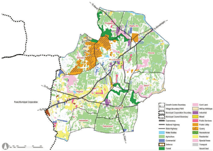
Wagholi town has rapidly developed along the NH 753F due to proximity to PMC, Kharadi IT Park, Lohegaon Airport and Shikrapur industrial area. The majority of the Growth Centre land is under agriculture (33.3%), with built-up areas concentrated around Wagholi Gaothan, Kesnand, Awhalwadi, Lonikand and along the NH 753F.
The total area of Wagholi Growth Center is about 110.78 sq km. Almost 35 % of the entire existing land is vacant land, followed by agriculture land, which is 33.3 %. The area under forest is 337.5 ha. which is almost 3 %, while the area under water bodies is roughly 2 %. It is observed that commercial and residential areas are 1.74 % and 7.3 %, respectively. ELU shows industrial and commercial corridor development majorly along the NH 753F. Residential nodal development is seen in Wagholi, whereas Lonikand, Perane, Awhalwadi, and Kesnand are dotted by residential developments and some areas by unplanned settlements. Public utilities and amenities together contribute about 0.69% only of the existing land use. This Growth Centre has a well known historical temple, Wagheshwar temple, along the national highway situated at Wagholi village. Government-owned lands are present in Lonikand, Perane, Wadhu Kh and along the NH-753F in Wagholi.
A number of stone quarries spread across Wagholi Growth Centre in villages of Wagholi, Bhavadi, and Lonikand, has been depleting the air quality of the region. The total area of the Wagholi quarry alone is about 5.75 sq km. It offers a tremendous opportunity to re-purpose the quarry land for recreational activities, water reservoirs and safeguarding the bio-diversity generated within the abandoned quarry lands.
The majority of Wagholi Growth Centre comes under the Blue zone of Air Force Restriction Zone, where NOC is exempted if the top elevation is 627 m AMSL or below. 460 ha of the area is observed under the red zone, limiting the development potential of the area.
Figure 22.3: Existing Land Use Map
Table 22.2Existing Land Use Area Statement
Land use category
Area (ha)
Proportion of Total Devel-oped Area (%)
Proportion of Total Area (%)
Residential
811.34
78.38
7.34
Commercial
192.14
18.56
1.74
Industrial
106.55
10.29
0.96
Public and semi public
411.78
39.78
3.73
Garden, Playground and Recreation
17.07
1.65
0.15
Public Utility
59.28
5.73
0.54
Transportation
283.1
27.35
2.56
Mix use
48.79
4.71
0.44
Special Areas
108.62
10.49
0.98
Defense
0.01
0.00
0.00
Total Developed Area
1035.2
Agriculture
3717.72
33.36
Water bodies
227.44
2.06
Vacant Land
3923
35.51
Quarry
575.16
5.21
Forest
337.82
3.06
Hill Top Hill Slope
227.28
2.06
Total Undeveloped Area
10011.15
Total Area
11078.82
Traffic congestions along the NH-753F, no bypass developed
Critical junctions: at Wagholi Gaothan, SH-68 and NH-753F junction, NH-548 DD and NH-753F junction
Scattered development within Wagholi and Kesnand
Absence of sewerage, stormwater drainage and solid waste management sites
460 ha area under the red zone of Airforce restriction
Non-developable 5.75 sq km Quarry land
22.3Proposed Role and Strategies
Wagholi is identified as a ‘Sub-regional Centre and IT Hub’ and has an independent character. The rationale behind assigning this role to Wagholi is because of
Its capacity for natural expansion for the IT Sector at Kharadi, Magarpatta with available land.
It fills the gap of CBD in the East of Pune Agglomeration and complements the business requirements of the proposed IT Hub.
Chapter 22: Growth Centre: Wagholi
It has potential to integrate the Sub-regional Center with a major transport hub as well as Infotech Park and affordable housing.
The High demand for commercial development likely to be generated by proposed extension to Metro (Ramwadi-Wagholi-Shikrapur), both the Ring Roads- PMRDA Ring Road & MSRDC Ring Road and Pune-Nashik High Speed rail.
It has potential for development of Town Planning Schemes.
Understanding the above, linear development along transit corridors such as the Pune Ahmednagar Highway, the Metro and the Ring road, is proposed along with a major node at Lonikand. Wagholi growth Centre is proposed to be one of the major high density residential Growth Centre and is expected to host majority of the service industries of PMR that would leverage its role of Regional Centre and Eastern IT hub with focus on IT, ITES, Offices & Retail, Finance, Fintech & Blockchain, R&D, Higher Education & Warehousing.
Table 22.3Population Projections
Village
2011
2018
2031
2041
Awhalwadi
5,671
7670
12424
17386
Bhawadi
2,584
3988
6984
10052
Kesnand
4,718
8787
13520
17302
Loni-kand
7,944
16519
24595
29910
Perane
8,993
12897
21134
29184
Fulgaon
2,404
4328
6552
8307
Taleranwadi
1,709
2218
3549
4980
Wadhu Kh.
2,284
3235
5903
8833
Wagholi (CT)
33,479
106638
164956
197926
Bakori
1,555
3925
5239
5551
Total
71,341
170206
264855
329431
The projected resident workforce based on the projected population through the URGD method is 138,712. Considering the proposed economic activities of all the growth centres, employment distribution was proposed based on the envisaged sectoral split for that Growth Centres. Accordingly, the employment to be generated for the Growth Centre for the year 2041 is estimated to be 211,395. The proposed residential density is about 125 PPH (12,500 persons/sq km).
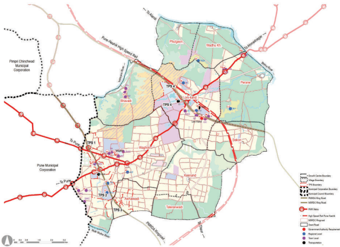
For the planning of public facilities distribution, Wagholi Growth Center is divided into three sectors: First is the entire Wagholi village, second consists of Kesnand, Awhalwadi, Taleranwadi and Bakori while the last sector includes northern villages as Lonikand, Perane, Phulgaon, Wadhu Kh and Bhavadi.
The boundaries of this planning division are shown on the Proposed Zoning Map. The projected sector-wise population statement is in Table 22.4.
Table 22.4Projected Population - Sectors
Sector
2011
2018
2031
2041
Sector 1
33,479
106638
164956
197926
Sector 2
13653
22600
34732
45218
Sector 3
24,209
40,968
65167
86287
Total
71341
170206
264855
329431
Proposed Zoning
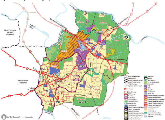
The proposed zoning would guide and determine the optimal and efficient land use for the next 20 years. The proposed zoning plan is an output of existing land use and physical conditions analysis, understanding of most pressing issues of the Growth Center, local knowledge of the place and deployment of five planning goals and allied physical planning strategies. The proposed zoning area statement is presented in Table 33.5.
Figure 22.4: Proposed Zoning Map
Table 22.5Proposed Zoning Area Statement
Land Use Category
Area (ha)
Proportion of Total Devel-oped Area (%)
Proportion of Total Area (%)
Residential
4005.77
66.24
36.16
Gaothan
47.12
0.80
0.43
Commercial
260.82
3.71
2.35
Industrial
486.17
6.39
4.39
Chapter 22: Growth Centre: Wagholi
Logistics
72.45
2.48
0.65
Public and semi public
148.51
2.56
1.34
Public Utility
78.05
1.35
0.70
Traffic & Transportation
941.51
15.67
8.50
Defense
48.57
0.81
0.44
Total Developed Area
6088.39
Agriculture (G1)
2836.82
25.61
Water bodies
206.78
1.87
Green Belt
140.74
1.27
Forest
329.62
2.98
Hilltop Hillslope
532.91
4.81
Recreational
174.27
1.57
Quarry
730.5
6.59
Afforestation
38.78
0.35
Total Non-Developable Area
4990.42
Total
11078.82
Translating Goals into the Plan
Proposed zoning ensures that the sectoral development goals are clearly conveyed through it. Proposed sectoral goals and their corresponding physical planning strategies are mentioned in Table 33.6.
Table 22.6Goals and Physical Planning Strategies
Goals
Development Sector Addressed
Physical Planning Strategies
Prudent
Employment and housing
Work- Live Hubs
Convenient
Roads and mass transport
Movement Lattice
Resilient
Environment protection
Green- Blue connectors
Efficient
Infrastructure and utilities
Decentralized resource management
Self- sufficient
Social facilities
Walkable Neighbourhoods
Prudent: Work-Live Hubs
For Wagholi Growth Center, the Work-Live concept is applied by:
Designating residential zones within 500 m around industrial and commercial zones to minimize workrelated trips for at least 30% of the resident workforce
Expansion to the existing industrial and commercial zones at the junction of high-speed rail, MSRDC Ring Road and National Highway (NH-753F) to reduce travel time for the workforce to commute within the Growth
Centre as well as to and fro other Growth Centers
Proposing Regional Centre at a central location of the Growth Centre
Out of the total proposed industrial zone over 186.6 sq km, industrial use over 5.2 sq km is envisaged in Wagholi Growth Centre, both based on projected employment and 50 workers/ha density. 50% of the IT activity, which is 1.9 sq km, is proposed to be carried out at Wagholi.
The industrial zone as per ELU was 106.55 ha while 113.40 ha was proposed in RP 1997. Thus considering the existing scenario of industrial development, the strategic infrastructure proposals and planning intent of Regional Plan, 486.17 ha of industrial zone is proposed for general industrial activity and IT activities.
The Development Plan intent is to promote IT development north of Wagholi village and in Lonikand along the NH 753F, High Speed Rail and MSRDC Ring road, which will provide good connectivity to industrial hubs of Markal and Uruli Kanchan. Thus the industrial Zone proposed as part of Town Planning Scheme, is recommended to be developed as IT Park. TP Scheme will enable its better implementation
The total logistic land use requirement of the Study Area is estimated to be 20.2 sq km considering projected demographics and area requirement of 55 sqm built-up area per person. 1 sq km of this estimated area is anticipated in Wagholi Growth Centre. However, considering the proposed role of the GC, the prevailing trend of warehousing and supplementary industries and the proposed strategic infrastructure projects, logistic use is proposed over 72.45 ha. This zone, being proposed at the junction of NH-548 DD and NH-753F, provides connectivity to the logistic centres of Markal and Vadki.
Land requirement for the residential zone is estimated based on a net residential density of 125 PPH. Further, 45% add-on is considered to account for amenity (15%), open spaces (10%) and roads (20%). Accordingly, the total gross area required for the projected GC population of 3,29,431 by 2041 is estimated to be 38.2 sq km.
Considering the projected population, net residential density, proposed role and existing growth trends within the Growth Centre, 38.87 sq km of gross residential zone is proposed. As per the Work Live hub concept, consolidated residential zoning is proposed in the Growth Centre. Understanding the current mature residential developments in Wagholi village with a projected population of 197,344 in 2041, residential use is proposed covering 1,639.96 ha of the village area. In its continuation, Lonikand (610.56 ha), Kesnand 682.76 ha) and Ahwalwadi (423.79 ha) form the second major residential node of the Growth Centre. Residential development at Lonikand, Perane and Bakori is envisaged to cater to the newly proposed Regional Centre and Multimodel Hub node. Town Planning Schemes are proposed at Wagholi and Lonikand
Land requirement for the commercial zone is estimated based on URDPFI guidelines, i.e. 0.6 ha per 1,000 population. An additional 30% is considered to account for roads (15%), open spaces (10%) and amenities (5%). Accordingly, the total commercial zone requirement for the Study Area is estimated to be 23.77 sq km. 260 ha from this area is proposed in the Growth Centre such that equitable distribution of commercial activities is facilitated.
Seven commercial nodes are proposed, serving in all four directions. First one serving Wagholi Gaothan edging the quarry development, one at the junction of PMRDA Ring Road and NH-753 F, third serving south of Wagholi village at junction of Ring Road and secondary arterial, fourth serving Kesnand Gaothan, fifth at the junction of MSRDC Ring Road, NH-753F - near to high-speed rail station, sixth node is abutting MMH and High Speed rail Station and last serving the Bakori Village.
Chapter 22: Growth Centre: Wagholi
The movement lattice concept also includes a mass transit corridor running through the Growth Center centre, high-speed rail crossing the Centre and Ring Road to encourage >50% of the residents to use mass transport for their daily commute.
A parallel system (30 m road) to NH-753F is proposed on its southern side, bypassing the congested section along the NH-753 F opposite to Wagholi Gaothan area and disconnecting it from local traffic, starting from Grant Road (PMC boundary) until the edge of Wagholi village on the north-east side. This bypass should be the topmost development priority of the Growth Centre.
A northern bypass is proposed considering Regional Plan 1997 provisions, bypassing even the Wagholi Gaothan area and connecting further to ODR-134. A slight deviation is introduced near its junction with NH-753F due to development of structures over its ROW.
Development of Bhavdi Road ODR-138, ODR-134, SH-68 and Awhalwadi Road should be taken on priority.
Grid-iron pattern of collector roads (15-24 m wide) is proposed in the Growth Centre, covering all the residential areas.
Collector roads (15-24 m wide) follow spacing of 300-500 m. Secondary arterials (30-45 m wide) follow a 1 to 2 km grid pattern, covering the entire residential zone.
Mass-Transit Lattice: Pune-Nashik High-Speed Rail cut across the Growth Centre via Bhavadi and Lonikand, parallel to MSRDC Ring Road.
Metro line is proposed along Pune-Ahmednagar Highway (Ramwadi-Wagholi-Shikrapur) and along PMRDA Ring Road connecting Lohegaon Airport with Wagholi.
Secondary arterials have the flexibility to run a dedicated bus service for faster transport and support the feeder system and last-mile connectivity.
All existing roads to be redeveloped and proposed roads are to be designated with at least 3m wide footpath on either side of the road, as the ‘pedestrian right of way’ and ‘hawker-free zone.’
Figure 22.5: Proposed Transport Network Map
Table 22.7Proposed Transport Network Statement
Road Category
Road names/ROWs
Proposed ROWs
Authority
Total Length (km)
Cost of Road Development (Cr.)
Primary
NH753F
60
NHAI
14.47
Secondary
SH116
45
PWD
14.18
SH68
30
PWD
16.92
Tertiary
MDR29
24
PWD
3
MDR56
24
PWD
3.1
ODR126
18
PWD
5.15
ODR132
18
ZP
2.12
ODR134
18
ZP
3.45
ODR138
18
ZP
8.98
Local
VR (Total)
15
ZP
38.67
Primary
MSRDC Ring Road
110
MSRDC
9.74
Existing internal road
Expressway
90
MSRTC
0
Total existing
PMRDA Ring Road
65
PMRDA
5.65 46.20
Secondary
45
PMRDA
13.4 70.68
Total Road Length
30
PMRDA
509.69
24
PMRDA
545.65
Tertiary
18
PMRDA
576.73
15
PMRDA
465.62
Local
12
PMRDA
133.77
Total Road Length
138.83 2348.34
Resilient: Green-Blue Connector
The existing forest areas at Kesnand, Phulgaon, Lonikand and Bhavdi are designated as protected areas.
Green Belt zoning is proposed between the river bank and the corresponding blue line for Mula-Mutha, Indrayani and Bhima Rivers.
All existing streams to be protected.
Water reservoirs within the quarry area need to be protected.
These protected Green-Blue features are recommended to be connected by a 30-45 m wide secondary
Chapter 22: Growth Centre: Wagholi
arterial road that would be upgraded as a tree-lined avenue by developing NMT corridors (>3 m each) on both sides of the road and segregated from footpaths.
Green lungs are proposed within 500 m walkable distance covering an area of 269.88 ha. These green lungs include active and passive recreational spaces. The total active recreational space works out to be 39.19 ha that include playgrounds, sport complex, stadium and multi-purpose ground. And the total passive recreational space works out to be 230.68 ha that include gardens, town park/ regional park, bio diversity park and green belt.
This concept is applied as follow:
Extention to water treatment plant over an area of 0.12 ha has been proposed at Bhavdi and at Wagholi over an area of 0.32 ha.
5 STPs are proposed, near Mula-Mutha river and Bhima river.
Two solid waste sites are proposed, one at the foothill of government-owned land along Bhavadi road, majorly serving Wagholi village within 3 km radius, and another at Perane over government owned land adjacent to Regional Park.
Renewable Energy Park (40 ha)is proposed at sites Wadhu Kh adjacent to MSEB sub station, making it easy to supply power into the electricity grid.
The existing power substation at Lonikand is maintained, and another is proposed at Kesnand (1.83 ha ) based on the requirement from MSETCL.
A fire station is provided along the NH-753F on amenity space within Wagholi.
Existing crematorium and burial grounds are maintained and expanded wherever required and feasible.
Table 22.8Proposed Infrastructure Demand
Infrastructure System
Demand (2041)
Unit
Utility Sites
Total Area
Water Supply
23.57
MLD
02 WTPs
0.76
Sewerage
23.43
MLD
05 STPs
3.79
Solid Waste
97.61
Tones/day
02 SWM
3.91
Self-sufficient: Walkable Neighbourhoods
This goal is set to increase the liability index of the Growth Centre. To do that, amenities are proposed within 500 m distance, leveraging the concept of Walkable Neighbourhoods. The concept entails providing basic infrastructure and services for education, health, sports, and recreation within the neighbourhood to have easy access to them by foot.
Amenity provision is made for the projected population by 2031 (2,64,855 ppl)
Neighbourhood level amenities are located within a 500 m radius from residential zones and are connected by collector/local roads to improve their accessibility from other neighbourhoods.
It is ensured that these amenities are made accessible with an appropriate road width as defined in the
planning norms and as highlighted in DCPR.
Proposed amenities are distributed as follow:
Wagholi is an established urban centre in the Growth Centre. Thus the concentration of amenities is observed here.
Education: Primary Schools and Secondary Schools are clubbed together and provided at newly opened up residential areas at Kesnand, Perane and north of NH-753 F within Wagholi village. 3 primary plus secondary schools are proposed, out of which 2 are in Wagholi and one is in Bakori. Expansion to five existing ZP schools is proposed with proper road access to each amenity. A medical college is proposed within the medical hospital premise at Wagholi. Education Complex is proposed at Bhavadi over government owned land, a central location with good connection to PMC and Regional Centre, in proximity to IT Park.
Health: Health Centres are provided considering walking radius within a Neighbourhood. 7 health centres are proposed, distributed across, at Wagholi (3), Kesnand (2), Awhalwadi (1) and Bakori (1). A Trauma Care Centre is proposed at Perane served by NH-753F, while Medical College is proposed at Wagholi slong PMRDA Ring road. Hospitals is proposed along MSRDC Ring Road adjacent to High Speed rail station within Lonikand and in Wagholi along the PMRDA ring road.
Socio-Cultural: Community halls are provided considering walking distance within a neighbourhood. 6 community halls are proposed within Wagholi, 2 at Kesnand, 1 each at Wadhu Kh, Lonikand and Awhalwadi. Four socio-welfare centres are proposed, 2 at Wagholi on amenity space and one at Lonikand over government land and at Perane. 2 Cultural centres are proposed, one near MMH, MSRDC Ring Road over government land and another adjacent to Vijay Stambh along NH-753F.
Open Space: Playgrounds are located near schools and are split into 2 with a minimum area of 0.8 ha to improve spatial distribution wherever required. 28 playground are proposed with 13 being in Wagholi, 3 in Awhalwadi, 4 in Kesnand, 2 in Bakori, 2 in Lonikand, 2 in Perane and one in Wadhu Kh. 21 neighbourhood gardens are proposed with 11 in Wagholi, 2 in Kesnand, 3 in Awhalwadi, 2 in Lonikand and Perane and one in Bakori. Town Parks are provided along/near water bodies within the green belt or government-owned lands. 2 town parks are proposed, out of which, one is proposed on government land near Bhavadi gaothan, another is proposed over quarry land, as “Wetland Biodiversity Park” that could help create a wetland ecosystem to act as carbon sinks. Such wetlands also attract migratory birds and can be tourist spots in the city. Regional Park is proposed over 60 ha government land on ‘Ridge Park’ theme creating another tourist attraction. Two sports complexes are proposed, one is provided at the newly opened up residential areas in Lonikand, again on government land and accessible by NH 548 DD and MSRDC Ring Road, while another is proposed at Wagholi abutting PMC boundary along the nala.
Residential: Public housing is critical in providing for affordable solutions to housing demand. 2 public housing reservations are proposed in Wagholi and two in Lonikand and one in Bhavadi. Out of the four, one is proposed over encroached government land adjacent to Wagholi gaothan, under the ‘in-situ’ scheme of PMAY. The housing proposed in Lonikand is considered to be developed by MHADA.
Commercial: Shopping Centre/market is provided at existing commercial nodes or near existing settlements or on available amenity spaces. Out of the 12 commercial amenities, seven are proposed as shopping centres and 5 as markets. The shopping centres are distributed across the Growth Centre, with 3 in Wagholi and each in Kesnand, Awhalwadi, Bakori and Perane. Markets are proposed especially near the existing settlements or gaothans for holding weekly bazaars. 3 markets are proposed in Wagholi while each in Kesnand and Lonikand. A Regional Centre over an area of 40 ha is provided at Lonikand on government land with proposed access by mass transport, i.e. metro, high-speed rail and MSRDC Ring Road along with NH-753F.
Transport: 2 Multimodal Hub are proposed adjoining the proposed high-speed rail station, within 500 m walkable distance from the proposed Metro station on NH-753F and near to MSRDC Ring Road and another MMH is proposed at the junction of PMRDA Ring Road, NH 753 F, Ramwadi-Wagholi Metro and Hinjawadi-Markal- Wagholi Metro. Bus Depot/ terminal and ISBT would be developed under these two multimodal hubs. The high-speed rail station is proposed at Lonikand based on the CTTS report. Parking spaces are proposed near amenities that provide for a larger crowd congregation.
Civic facilities requested by various government authorities: A post office is proposed for amenity space in Wagholi as requested by MFL Division Pune. The District Deputy Registrar’s office requirement is proposed to be covered under the Regional Centre.
Chapter 22: Growth Centre: Wagholi
Table 22.9Summary of Land Ownership of Proposed Amenities
Land Ownership
No of Amenity
Total Area (ha)
Government Land
30
164.06
Private Land
65
75.98
Amenity Space
38
29.39
Other
9
21.79
Total
142
291.32
Implementation Strategy for the Proposed Reservations
Town Planning Scheme: PMRDA envisages implementing the Development Plan proposals by enabling the provision of Town Planning Schemes, which will considerably reduce liability towards the direct cost of acquisition of land required for social and physical infrastructure. To achieve the economic role of ‘Regional Centre & IT Hub’, 4 town planning schemes are proposed at Awhalwadi, Wagholi and Lonikand. The reservations proposed to be developed using the TPS mechanism are as follows:
a. Strategic Project: IT Park, Medical Hub, MMH, PMRDA Ring Road, 30m arterial road parallel to NH 753 F b. Amenities: Play grounds, gardens, health centres, STP, community halls
The other proposals/reservations of the Development Plan are proposed to be acquired and developed through the mechanism of Accommodation of Reservation and Transfer of Development Rights (TDR) policy. It is estimated that all proposed roads and 50% of the public reservations will be acquired through TDR/FSI/ AR. Remaining
The remaining reservations will be acquired under the provision of the Land Acquisition Act by paying monetary compensation.
Figure 22.6: Strategic Projects
Town Level
Chapter 22Growth Centre: Wagholi
22.1 Summary
Wagholi is identified as a Regional Centre and IT Hub with an independent character. The primary reason to assign this economic role to Wagholi is its capacity to evolve as a natural extension for the IT Sector at Kharadi and Magarpatta. Further, it will act as a major transport hub due to planned major transit routes such as ring roads, MRTS, rail routes passing through it. It will fill the gap of a business district in the east of Pune agglomeration and complement the business requirements of the proposed IT hub. With substantial land available for development, it will cater to affordable housing and absorb high demand for commercial development likely to be generated by the proposed Metro extension (Ramwadi-Wagholi-Shikrapur) PMRDA and MSRDC Ring Road developments and Pune-Nashik high-speed rail development.
Promote IT/ITES along with Financial Services, Fintech and Blockchain activities through the development of the proposed Regional Centre at Lonikand.
Promote logistic and warehousing activities by consolidating cluster development leveraging existing high demand along MSRDC Ring Road.
Promote Work-Live hub concept by increasing residential development adjacent to existing industrial activities
Strengthen and develop regional linkages
Develop bypasses to primary roads for avoiding the congestion due to commercial and logistics activities at Wagholi and Lonikand
Develop multi-modal hub (MMH) at Wagholi and Lonikand that would connect Metro, High-Speed Rail, Ring Road, National Highway and ISBT terminal with each other; Further connect the MMH to regional amenities such as regional centre, regional park, sports complex and medical hospital and college campus through feeder system.
Develop a grid network of secondary and tertiary roads for a smooth movement within the Growth Centre
Protect all the natural streams in the Growth Centre.
Develop water reservoirs within the quarry area and fill them with excess water from Indrayani and Bhima River.
Establish green-blue links by connecting Quarry lands, streams, forest and green belts of three rivers: Mula-Mutha, Indrayani and Bhima.
Promote self-sufficient town by proposing required amenities and utilities for the projected population
Regional Centre at Lonikand (36.60 ha)
Regional Park at Perane (61.09 ha)
Trauma Care Hospital (3.9 ha), Helipad and Police Station at Phulgaon along the NH-753F
Residential Town Planning Schemes at Wagholi
High-Speed Rail and its station
Metro line extension from Ramwadi towards Shikrapur via Wagholi
PMRDA Ring Road and MSRDC Ring Road
Wetland Biodiversity Park/Quarry Park (Town Park at Bhavadi) (7.05 ha)
Medical College and Hospital at Wagholi (7.59 ha)
IT Park at Lonikand (Part of TPS)
Education Hub at Bhavdi
30m bypass to NH-753F on northern and southern side