31.1 Summary
Uruli Kanchan is envisioned to be developed into an “Agro Processing Hub”. The primary reason to assign this economic role to Uruli Kanchan is to leverage the agro-processing activities prevailing in this area along with the presence of institutions such as the Sugar Institute. Further, this area falls under the irrigation command area, showcasing good quality agriculture produce.
| Growth Centre Area | 7213.20 ha |
|---|---|
| Population | 66,971 (2011); 106,088 (2031); 116,937 (2041) |
| Net Population Density | 125 PPH |
| Resident Workforce | 52,032 (2041) |
| Employment | 38,957 (2041) |
| Households | 27,463 (2041) |
| Proposed Zones | Residential (1529.191 ha), Industrial (309.63 ha), Commercial 250.64ha), Logistic (42.64 ha) |
-
Develop the area into an Agro-Processing Hub to foster activities such as agro-processing, food processing, high-value agriculture, agro-tourism
-
Develop regional linkages such as MSRDC Ring Road and Crescent Railway projects
-
Promote logistic activities supporting agro-processing industry
-
Promote Work-Live hub concept by increasing residential development adjacent to existing industrial activities
-
Develop bypass to primary roads avoiding congestion
-
Develop a grid network of secondary and tertiary roads for a smooth movement within the Growth Centre
-
Develop pilgrimage and agro-tourism facilities at Theur
-
Promote self sufficient town by proposing required amenities and utilities for the projected population
-
Protect all the natural streams in the Growth Centre.
-
Establish green-blue links by connecting streams, forest and green belt along the Mula-Mutha River
-
Crescent Railway and its station at Koregaon Mul
-
MSRDC Ring Road
-
Agro-processing and R&D Hub at Sortapwadi
-
Logistic Hub at Koregaon Mul
-
Town Planning Scheme at Koregaon Mul
-
Wellness Centre at Theur
-
Tourist Cluster at Theur consisting Tourist Centre, Cultural Center and Town Park
-
Regional Park (botanical garden) along the Mula-Mutha River at Naygaon
-
Sports Complex at Naygaon
-
Public Housing Project at Naygaon
Existing Situation Analysis
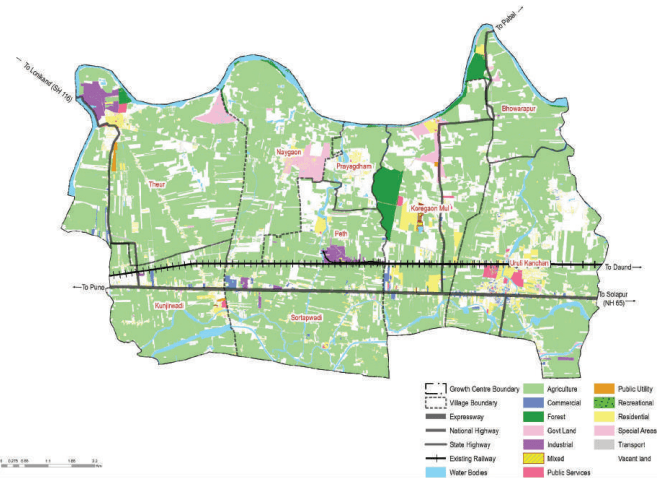
Uruli Kanchan is a moderately dense town with horizontal growth along the existing railway line (Pune- Daund) and NH-65. The majority of land in this area is under agricultural use, with built-up areas concentrated around Uruli Kanchan, followed by Kunjirwadi, Theur, Sortapwadi and Koregaon Mul villages.
Uruli Kanchan Growth Centre has nine villages, namely Bhowrapur, Koregaon Mul, Kunjirwadi, Theur, Uruli Kanchan, Sortapwadi, Prayagdham, Naygaon and Peth. The total area of the GC is 7214.34 Ha. According to Census 2011, the Growth Centre population was 66,971, and the estimated population for 2018 is 92,161 with 38,683 resident workforce.
Uruli Kanchan Growth Centre enjoys great locational advantage with its proximity to adjoining Loni Kalbhor, Wagholi areas and strong regional connectivity through existing and proposed infrastructure developments such as MSRDC Ring Road, national highway, state highway and existing railway line.
A portion of the GC was part of the RP 1997, falling under Sector K. RP 1997 recommended residential and industrial zones in the GC, attracting many planned layout developments in the area.
Uruli Kanchan Growth Centre is located on the eastern side of PMR within Haveli taluka. It shares a boundary with Loni Kalbhor on the west with rural areas on the north, east and south. It is approximately 36 km from Pune city.
Uruli Kanchan has main connectivity through Pune-Solapur National Highway (NH-65) and the existing Pune-Daund railway line. The proposed MSRDC Ring Road and Crescent Railway Line passing north-south through Koregaon Mul and Uruli Kanchan, connecting NH-65 and the existing railway line. Further, the GC enjoys robust regional connectivity through NH-548DD and SH-116, connecting it with Wagholi Growth Centre and Satara. MDR-138 connects villages such as Kunjirwadi, Peth and Uruli Kanchan to NH 548DD while MDR-34 connects Theur village to Uruli Kanchan railway station.
Figure 31.1: Location and Physiography
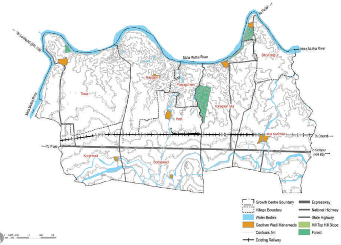
Mula-Mutha River edges the northern part of the Uruli Kanchan Growth Center, while the southern edge is lined by two canals, i.e. Sortapwadi canal and Mutha right bank canal. The entire area falls under the irrigation command area of the Mutha right bank canal. The highest point is 565 m altitude to 520 m with a gradient of about 1:0.0079 depicting a very gentle slope towards the Mula-Mutha river. 116.11 ha of forest areas are present in Koregaon Mul and Naygaon.
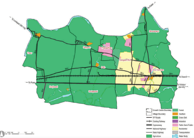
Uruli Kanchan was one of the four urban growth centres proposed in RP 1997, for which Sector K plan was sanctioned. In the said Growth Centre, western part of Sector K has been considered.
Within Sector K of the RP 1997, residential zoning over 776 ha was proposed at Uruli Kanchan and Koregaon Mul. 77.52 % of the GC area (5,592.91 ha) was kept as agricultural use in RP 1997 zoning. Prayagdham occupied a majority of the public-semi-public area.