Ranjangaon is located along Pune-Ahmednagar Highway at a distance of 54 km from Pune city. It is one of the major industrial hubs of PMR, with its MIDC area hosting more than 200 domestic and global entities such as LG, FIAT, Whirlpool, Bombay Dyeing and Bekaert. It is also known as the place of Mahaganapati, one amongst the Ashtavinayak.
Ranjangaon is envisioned as an “Integrated Industrial Town” with a focus on promoting industrial and residential real estate through townships and town planning schemes. It is proposed to develop this new town around the existing MIDC area with a balanced distribution of social infrastructure and amenities.
Promote cultural and tourism activities around Maha-Ganapati Ashtavinayak
Promote Work-Live hub concept by increasing residential development adjacent to existing industrial activities
Develop bypasses to primary roads for avoiding congestion due to pilgrimage activities at Ranjangaon and logistic activities
Develop a grid network of secondary and tertiary roads for a smooth movement within the Growth Centre
Promote affordable living supporting the MIDC industrial development
Establish green-blue links by connecting forest and green belts of the Ghod River
Promote self-sufficient town by proposing required amenities and utilities for the projected population
Southern bypass to NH-753F from Ranjangaon Ganpati to Shirur Part via Karegaon
Town Planning Scheme at Karegaon
Town Centre at Karegaon
Socio-Cultural Centre and Garden at Ranjangaon Ganpati
Sports complex at Karegaon
35.2Existing Situation Analysis
Ranjangaon Growth Centre includes three total villages and part of Shirur village, namely Ranjangaon Ganpati, Karegoan, Dhok Sangavi, Shirur part (Annapur, Saradwadi, Tardobachiwadi, Kardilwadi). The total area under this Growth Centre is 7541.46 ha. According to Census 2011, the Growth Centre population was 40,381, and the estimated population for 2018 is 87444 with 23,668 resident workforce
Ranjangaon Growth Centre enjoys great locational advantage with its proximity to adjoining Ranjangaon MIDC and Pune-Ahmednagar Highway, one of the busiest national highways in PMR. The presence of renowned electronics companies and cultural significance rendered through it being the Maha Ganapati Temple site makes Ranjangaon one of the significant areas in Maharashtra.
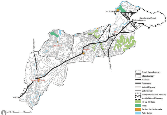
Ranjangaon Growth Centre is located on the northeastern side of the PMR within Shirur Taluka. It shares a boundary with Shirur Municipal Council on the northeastern side, whereas the remaining area is surrounded by rural areas. It is located along NH-753F (i.e. Pune-Ahmednagar Highway) and is 54 km from Pune city and 61 km from Pimpri Chinchwad city. Figure 35.1 shows the state highway connecting NH-60 (Pune-Nashik Road) and joining NH-753F near Ranjangaon Ganpati village. SH-113 (Shirur-Satara Road) provides good inter-regional connectivity. Other than NH-753F, major district roads MDR-52, MDR-114 and MDR-100, MDR -115, MDR-90 also contribute towards improving intra-regional connectivity to MIDC developments within Ranjangaon.
Ranjangaon is located on the eastern plains of PMR with a presence of few undulation surfaces in parts north of MIDC and south of Shirur Municipal Council area. The highest point is at 660 m altitude, sloping towards the northeast to 560 m and sloping towards south to 580 m, showing a very gentle slope. The Ghod River edges the northern part of the Growth Centre, with a stream aligning the NH-753F. Ghod dam is located just east of the Growth Centre near Golegaon village. The Chaskaman canal is situated south of Ranjangaon Ganpati gaothan. Another stream starting from the north of Ranjangaon flows south to meet the Bhima river. Almost 40% of the land is under agriculture. 97.5 ha of forest land is present in Shirur part and Dhok Sangavi.
Figure 35.1: Location and Physiography
Chapter 35: Growth Centre: Ranjangaon
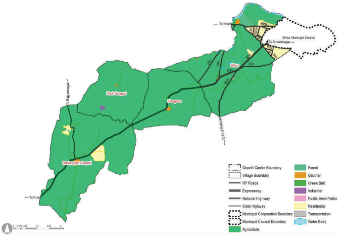
While Ranjangaon did not fall under any of the proposed RP sectors, however, a residential zone over a total area of 301 ha was proposed. Out of the total residential area, 171 ha was proposed at Shirur while 83 ha was proposed at Ranjangaon Ganpati. The majority of the residential zone has fructified due to the development of MIDC areas and proximity to Shirur Council and major transport corridors. Moreover, RP 1997 has 52 ha marked as forest in Shirur part. RP 1997 proposed a bypass road to NH 753 F at Shirur village.
Figure 35.2: RP 1997 Zoning Map
Table 35.1RP 1997 Area Statement
Land use category Area (ha)
Proportio oped Are
n of Total Devel- Proportio a (%) (%)
n of Total Area
Residential
301.72
72.76
4.00
Industrial
4.47
1.08
0.06
Public and semi public
4.74
1.14
0.06
Transportation
103.72
25.01
1.38
Total Developed Area
414.65
100.00
5.50
Agriculture
6939.18
92.01
Water bodies
133.43
1.77
Green Belt
3.13
0.04
Forest
51.07
0.68
Total Undeveloped Area
7126.81
94.50
Total Area
7541.46
100.00
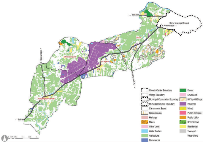
MIDC occupies 10.41sqkm of land which is almost 14% of the total area. The industrial zone within the Growth centre, excluding MIDC area is 51 ha, followed by agricultural use with 40% of the land under cultivation. Substantial size vacant land of 2621 ha is observed in the GC at Dhok Sangavi, Karegaon and Shirur. The residential component in Ranjangaon is comparatively small due to dotted residential development. Residential nodal development is observed in Ranjangaon Ganpati, Karegaon and the southern part of Shirur Municipal Council.
Warehouse expansion is seen south of the MIDC area across the highway. Warehousing and logistic developments are also observed south of the MIDC area and NH 753 F near Karegaon village. The Maha Ganpati has a land of 0.35 ha under them, and the total area under existing schools and health care is 79 ha.
Figure 35.3: Existing Land Use Map
Table 35.2Existing Land Use Area Statement
Land use category
Area (ha)
Proportion of Total Devel-oped Area (%)
Proportion of Total Area(%)
Residential
191.87
13.53
2.54
Commercial
86.27
6.08
1.14
Industrial
838.35
59.11
11.12
Public and semi public
19.33
1.36
0.26
Garden, Playground and Recreation
8.79
0.62
0.12
Mix use
3.79
0.27
0.05
Public Utility
1.35
0.10
0.02
Government Land
18.85
1.33
0.25
Chapter 35: Growth Centre: Ranjangaon
Transportation
249.63
17.60
3.31
Total Developed Area
1418.23
100.00
18.81
Agriculture
2998.62
39.76
Water bodies
173.58
2.30
Vacant Land*
2621.70
34.76
Quarry
8.54
0.11
Forest
97.53
1.29
Hill Top Hill Slope
206.01
2.73
Special Areas
17.25
0.23
Total Undeveloped Area
6123.23
81.19
Total Area
7541.46
100
Note: Only building footprint is considered to calculate areas under residential, industrial, commercial and PSP use. It excludes the vacant areas adjoining such a building footprint. Thus, such vacant spaces are covered under the Vacant Land Use category, along with barren lands.