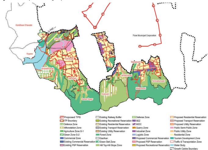
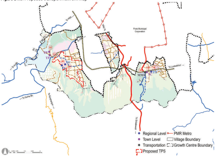
Khadakwasla comes under Haveli Taluka and comprises of 13 villages, namely, Kondve Dhavde, Kopare, Nanded, Khadakwasla, Kirkitwadi, Nandoshi, Sanas Nagar, Kolawadi, Jambhulwadi, Bhilarewadi, Nimbalkarwadi, Mangewadi, Narhe. The total planning area is about 59.11 Sq. km. According to census 2011 population of planning area is 77,258. Key strength of Khadakwasla Growth Centre is its location, adjoining to PMC and well connectivity with PMC through NH and SH.
Location &Connectivity
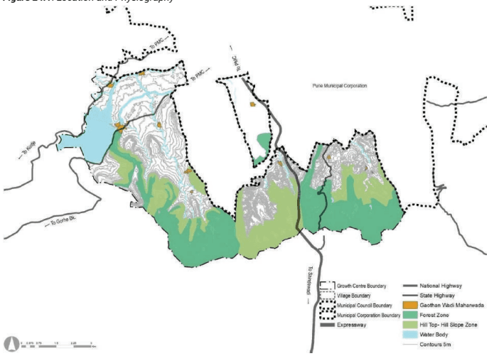
Khadakwasla is located on the southern side of PMC next to the Defense land within Haveli Taluka. It is surrounded by Khed Shivapur on the south-east side, Haveli Rural on the south, west and southern west side, PMC on the East. The south-western edge is flanked by the Western Ghats region. Entire area is situated on undulating surface. The north-western front is adorned by the Khadakwasla dam area. Only towards the PMC side, the gradient of the slopes allow development, Due to hilly nature of the planning area. Khadakwalsa growth centre connected with PMC by SH 133 and SH 115. SH 126 connect PMC at Katraj junction. NH 48 connect growth centre with proposed industrial development in Khed-Shivapur growth centre.
Mutha River edges the northern part of Growth Centre, with a stream aligning the SH 115 flow towards the PMC. Khadakwasla Dam is located nortern west of planning area near Khadakwalsa Village. Canal starting from south of Khadakwasla dam flows toward Swargate in PMC. Most of the area on southern side of growth centre is under HTHS and Forest.
Figure 24.1: Location and Physiography
Chapter 24 Growth Centre: Khadakwasla
Regional Plan (1997) Analysis
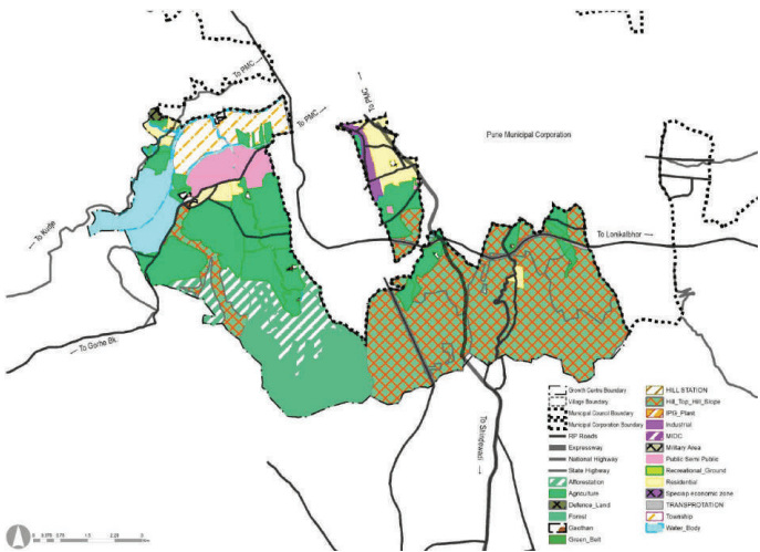
This growth centre forms part of sector E and sector F. Area along Sinhagad road was proposed as Residential zone in village Kondhave-Dhawade, Kirkatwadi. Narhe village is now surrounded by PMC, had residential zone in RP. Nanded city township cover most of the area of Nanded village. In RP 1997, Industrial zone was proposed in Narhe village. Green belt of 30 M was demarcated for river for Mutha river. 90 M wide road was proposed from Bhor taluka which is modified as 110M PMRDA ring road. Sinhagad road was proposed 36M with suitable diversion alignment from development. 30M wide road link was proposed to connect NH 48 and SH 133. CWPRS – Central water power research Station was important proposal in growth centre as per RP. The rest of the area not earmarked for specific zones is marked in Agricultural/ No development zones.
Total developable land as per RP 1997 is 971 Ha. out of which 540 Ha was proposed for residential zone. 2.98% of total growth centre was proposed for Transportation. Hilltop hill slope cover 2315Ha area in Khadakwasala growth centre. 56 Ha of industrial area proposed in Narhe. 4940 Ha of land is non developable which share 83.57 %.
Figure 24.2: RP 1997 Zoning map
| Land use category | Area (ha) | Percentage of Total Developable Area | Percentage of Total Area |
|---|---|---|---|
| Residential | 540.56 | 56% | 9.14% |
| Industrial | 56.79 | 6% | 0.96% |
| Public semi Public | 197.5 | 20% | 3.34% |
| Transport | 176.38 | 18% | 2.98% |
| Total Developable Area | 971.23 | 100% | 16.43% |
| Agriculture | 1169.35 | 19.78% | |
| Forest | 607.77 | 10.28% |
| Hilltop Hillslope | 2315.19 | 39.17% |
|---|---|---|
| Defence | 14.08 | 0.24% |
| Afforestation | 448.12 | 7.58% |
| Green Belt | 1.44 | 0.02% |
| Water Body | 384.06 | 6.50% |
| Total Non-Developable Area | 4940.01 | 83.57% |
| Total | 5911.24 | 100% |
Existing Land Use
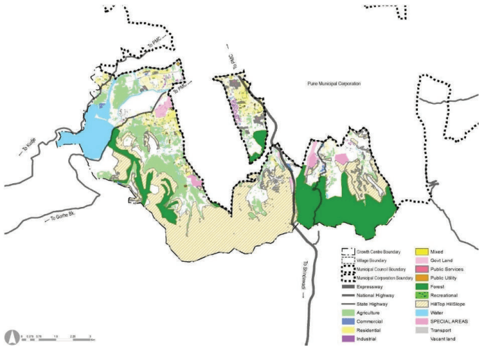
Residential area component in Narhe is comparatively very high due to concentrated residential development spread across. Nanded village also has very high residential development due to integrated township and residential layout. Residential nodal development is seen in Narhe, Nanded and Kirkitwadi. Industrial development occurred at Narhe village in some extent.
HTHS occupying 1913 ha of land, almost 34 % of the land of total planning area. Followed by agriculture land, which is 11.20% of the total planning area.A good amount of vacant land, 20% of total area is found in Bhilarewadi, Narhe and Kirkitwadi providing development opportunity.
Most of the forest land found in Bhilarewadi and Nandoshi, covering total area of 946 ha. which is 17% of total planning area. Nimbalkarwadi, Kolavadi, Sanas nagar and Khadakwasle has very high HTHS, covering total area of 1913 Ha which is 34% of total planning area. Total water body area within planning area is 392 Ha due to presence of Khadakwasle dam, Mutha river and water canal.Khadakwasla Growth Centre enjoys great locational advantage due to its proximity to adjoining PMC and presence of accessibility through Mumbai-Banglore National highway, one of the busiest transport route in PMR.
Figure 24.3: Existing land use map
Chapter 24 Growth Centre: Khadakwasla
| Land use category | Area (ha) | Percentage of Total Developable Area | Percentage of Total Area |
|---|---|---|---|
| Residential | 267.24 | 45% | 4.69% |
| Commercial | 36.08 | 6% | 0.63% |
| Industrial | 29.57 | 5% | 0.52% |
| Public semi Public | 132.85 | 23% | 2.33% |
| Transport | 119.46 | 20% | 2.10% |
| Public Utilities | 2.29 | 0% | 0.04% |
| Total Developable Area | 587.49 | 100% | 10.31% |
| Agriculture | 638.32 | 11.20% | |
| Vacant land | 1152.17 | 20.22% | |
| Forest | 946.77 | 16.62% | |
| Hilltop Hillslope | 1913.41 | 33.59% | |
| Special areas | 54.26 | 0.95% | |
| Recreational | 12.3 | 0.22% | |
| Water Body | 392.2 | 6.88% | |
| Total Non-Developable Area | 5109.43 | 89.69% | |
| Total | 5696.92 | 100.00% |
Issues in Existing Scenario
-
Residential Zone in some area is densely developed as per proposed RP zoning. This creat congestion in these areas.
-
Sporadic development is observed surrounding gaothan, where no RP zone was proposed. Major share of illegal construction is present at such location.
-
Major unauthorized development is observed along transport corridors i.e NH-48.
-
Less availability of government land for infrastructure development.