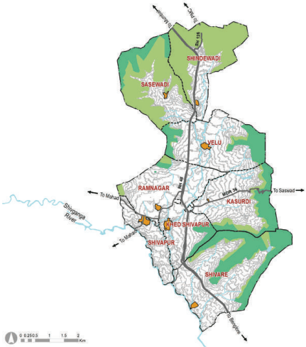
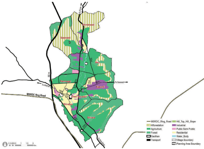
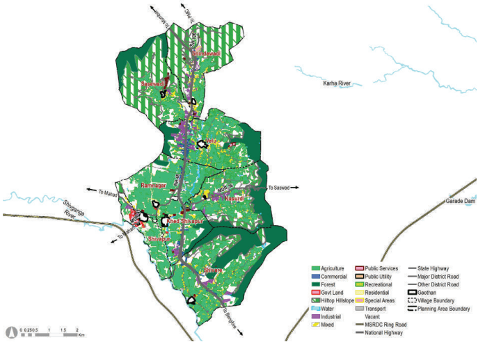
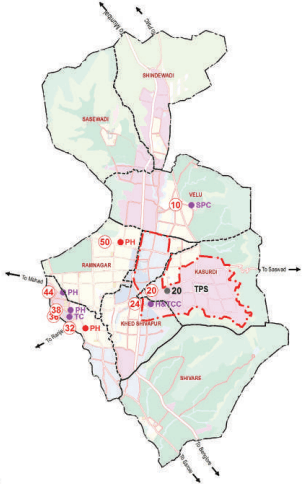
Khed Shivapur Growth Centre is envisioned as an ‘Ancillary Industrial Hub’ leveraging upon following assets;
-
Potential for extension of existing Industrial Cluster, with land reserved by RP Zoning.
-
Existing accessibility from NH 48, and enhanced location potential created by 110M MSRDC Ring Road and Proposed CSR International Airport makes it potential hub for MSME industries, logistics and warehousing activities.
-
Residential development around Work Hub encouraged through Integrated Town planning Scheme.
-
Protection of Green-Blue lattice by designated green belt along blue line of Shivganga river,
-
Protection of Hills and water bodies
| Village | 2011 | 2018 | 2031 | 2041 |
|---|---|---|---|---|
| Kasurdi | 1,512 | 2,849 | 3,832 | 4,242 |
| Khed Shivapur | 3,665 | 4,421 | 5,076 | 5,406 |
| Ramnagar | 2,349 | 2,624 | 3,134 | 3,526 |
| Sasewadi | 1,198 | 1,349 | 1,630 | 1,845 |
| Shindewadi | 2,054 | 2,680 | 3,344 | 3,738 |
| Shivapur | 2,588 | 2,814 | 3,234 | 3,557 |
| Shivare | 2,412 | 3,349 | 4,088 | 4,426 |
| Velu | 4,256 | 4,980 | 6,074 | 6,859 |
| Total | 20,034 | 25,066 | 30,411 | 33,599 |
The projected resident workforce based on the projected population through the URGD method is 16063. Considering the proposed economic activities of all the growth centres, employment distribution was proposed based on the envisaged sectoral split for that Growth Centres. Accordingly, the employment to be generated for the Growth Centre for the year 2041 is estimated to be 50,702. The proposed residential density is about 125 PPH (12,500 persons/sq km).
For the planning of sustainable and self-sufficient infrastructure and amenities distribution with less population density, the Growth Centre is considered as a single sector.
The proposed zoning would guide and determine the optimal and efficient land use for the next 20 years. The proposed zoning plan is an output of existing land use and physical conditions analysis, understanding of most pressing issues of the Growth Center, local knowledge of the place and deployment of five planning goals and allied physical planning strategies. The proposed zoning area statement is presented in Table 33.4.
Chapter 33: Growth Centre: Khed Shivapur
Figure 33.4: Proposed Zoning Map
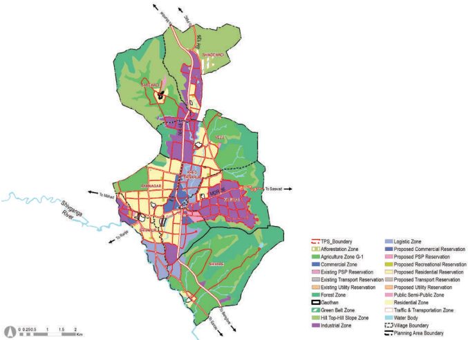
| Land use category | Area (ha) | Proportion of Total Devel-oped Area (%) | Proportion of Total Area (%) |
|---|---|---|---|
| Residential | 476.48 | 31.15% | 12.50% |
| Gaothan | 30.87 | 2.02% | 0.81% |
| Commercial | 63.91 | 4.18% | 1.68% |
| Industrial | 465.30 | 30.42% | 12.21% |
| Public semi Public | 36.67 | 2.40% | 0.96% |
| Transport | 260.23 | 17.01% | 6.83% |
| Logistic Zone | 190.73 | 12.47% | 5.00% |
| Public Utilities | 5.46 | 0.36% | 0.14% |
| Total Developed Area | 1529.65 | 100.00% | 40.12% |
| Afforestation Zone | 29.93 | 0.79% | |
| Agriculture | 803.52 | 21.08% | |
| Forest | 656.56 | 17.22% | |
| Hilltop Hillslope | 716.29 | 18.79% | |
| Green Belt | 7.93 | 0.21% |
| Recreational | 11.86 | 0.31% |
|---|---|---|
| Water Body | 56.54 | 1.48% |
| Total Non-Developable Area | 2282.64 | 59.88% |
| Total | 3812.29 | 100.00% |
Proposed zoning ensures that the sectoral development goals are clearly conveyed through it. Proposed sectoral goals and their corresponding physical planning strategies are mentioned in Table 33.5.
| Goals | Development Sector Addressed | Physical Planning Strategies |
|---|---|---|
| Prudent | Employment and housing | Work- Live Hubs |
| Convenient | Roads and mass transport | Movement Lattice |
| Resilient | Environment protection | Green- Blue connectors |
| Efficient | Infrastructure and utilities | Decentralized resource management |
| Self- sufficient | Social facilities | Walkable Neighbourhoods |
For Khed Shivapur Growth Center, the Work-Live concept is applied by:
-
Designating residential zones following RP zones within 500 m around industrial and commercial zones along transport corridor to minimize work-related trips for at least 30% of the resident work force.
-
Expansion of industrial zone at Shindewadi, Kasurdi, Velu, Shivapur and along NH48.
-
Designating logistic zone at junction of NH 48 and MDR 36 sandwitched betweeen residential area of Kasurdi village and Ramnagar village.
-
Town Centre is proposed in Shivapur near gaothan.
-
Wholesale market is proposed in village Shivapur.
Out of the total proposed industrial zone over 18,660 Ha, industrial use over 470 Ha is envisaged in Khed Shivapur Growth Centre, both based on projected employment and 50 workers/ha density.
The industrial zone as per ELU was 65.3 ha while 194.28 ha was proposed in RP 1997. The planning intent is to consolidate industrial zone around existing and balance industrial zone proposed at Shindewadi, Kasurdi, Shivapur, Velu and along NH 48. Integrated Industrial Town Planning Scheme is proposed at Kasurdi to consolidate the industrial development, enabling better trunk infrastructure. Thus, considering the existing scenario of industrial development, strategic infrastructure proposals within the growth centre and planning intent, 464.32 Ha of industrial zone is proposed.
The total logistic land use requirement of the Study Area is estimated to be 2020 Ha. considering projected demographics and area requirement of 55 sqm built-up area per person. 200 Ha of this estimated area is anticipated in Khed Shivapur Growth Centre. However, considering the proposed role of the GC, the prevailing trend
Chapter 33: Growth Centre: Khed Shivapur
of warehousing and supplementary industries and the proposed strategic infrastructure projects, logistic use is proposed over 190.73 Ha. This zone, being proposed in Integrated Industrial Town Planning Scheme at Kasurdi and Khed Shivapur village near Industrial zone adjoining to Mumbai Bangalore National Highway (NH 48) and Proposed Airport Road (MDR 36).
Land requirement for the residential zone is estimated based on a net residential density of 125 PPH. Further, 45% add-on is considered to account for amenity (15%), open spaces (10%) and roads (20%). Accordingly, the total gross area required for the projected GC population of 33,599 by 2041 is estimated to be 390 Ha.
Considering the projected population, net residential density, proposed role and existing growth trends within the Growth Centre, 476.48 Ha of gross residential zone is proposed. As per the Work Live hub concept, consolidated residential zoning is proposed in the Growth Centre. Existing gaothans at villages such as Shivapur, Khed Shivapur and Ramnagar are considered as social nucleus and residential real estate hot spots. To drive the future growth, a residential zone is allocated at periphery of 200m along the gaothan of these villages for future expansion. Residential spread is proposed in Velu and Kasurdi villages, supporting the work live concept.
Land requirement for the commercial zone is estimated based on URDPFI guidelines, i.e. 0.6 ha per 1,000 population.The total commercial zone works out to be 26 Ha, while 63.91 Ha commercial zone is proposed to account for equitable distribution of commercial activities. Commercial zone is proposed at 2 major nodes, along NH 48 in Khed Shivapur village and other near town center in Shivapur village.
-
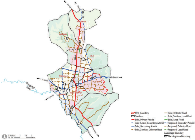
30M wide Bypass to NH 48 is proposed in two parts. One runs from Shindewadi to Kasurdi on the east of NH 48, while the other runs from Khed Shivapur to Varve Bk in Nasrapur Growth Centre, on the west of NH 48.
-
For connectivity to Airport, MDR 36 is proposed as 30M wide secondary road.
-
Grid-iron pattern of collector roads is proposed in the Growth Centre covering the entire residential and industrial zone.
-
Collector roads (15-24m wide) follow spacing of 300-500m while Secondary arterial (30-45m wide) follow a grid of 1 to 2 km covering the entire residential zone.
-
Secondary arterials have the flexibility to run a dedicated Bus service for faster transport and support the feeder system & last mile connectivity.
-
All the proposed roads are to be designated with at least 3m wide footpath on either side of the road, as the ‘pedestrian right of way’ and as a ‘hawker-free zone’.
Figure 33.5: Proposed Transport Network Map
| Road Category | Road names/ ROWs | Proposed ROWs | Authority | Total Length (km) | Total road development cost (INR Cr) |
| Primary | NH48 | 60 | NHAI | 11.11 | |
| Secondary | SH 126 | 30 | PWD | 1.22 | |
| MDR 36 | 30 | PWD | 5.25 | ||
| MDR 41 | 30 | PWD | 0.35 | ||
| VR (Total) | 30 | ZP | 3.56 | ||
| Tertiary | MDR 36 | 24 | PWD | 1.44 | |
| ODR 108 | 18 | ZP | 0.88 | ||
| VR (Total) | 15,18,24 | ZP | 13.69 | ||
| Local | MDR 41 | 12 | PWD | 0.29 | |
| VR (Total) | 9,12 | ZP | 0.95 | ||
| DP Roads | |||||
| Secondary | 30 | PMRDA | 9.07 | 132.30 | |
| Internal Road | 30 | PMRDA | 2.92 | 42.55 | |
| Tertiary | 24 | PMRDA | 7.21 | 39.67 | |
| 18 | PMRDA | 36 | 254.00 | ||
| 15 | PMRDA | 10.99 | 59.38 | ||
| Local | 12 | PMRDA | 2.57 | 7.58 | |
Chapter 33: Growth Centre: Khed Shivapur
| 12 | NHAI | 22.18 | - | ||
|---|---|---|---|---|---|
| 9 | PMRDA | 0.42 | 2.20 | ||
| Total Road Length | 91.36 | 537.68 |