Talegaon is envisioned to be developed into an “Industry 4.0 Hub”. The primary reason to assign this economic role to Talegaon is to leverage the established automobile and engineering industrial ecosystem at Talegaon MIDC. Further, the Growth Centre enjoys locational advantage with robust regional connectivity through major transit corridors such as Pune-Mumbai Expressway, Pune-Bangalore National Highway, Pune-Lonavala-Mumbai Railway Line and proposed PMRDA and MSRDC Ring Road.
Develop ecosystem for “Industry 4.0 Hub” by envisaging three development corridors:
a. First corridor: industrial corridor capturing planned expansion of Talegaon MIDC and served by proposed Crescent Railway (serving mainly freight logistics to Growth Centres having industrial character)
b. Second corridor: transit conversant residential developments along the Pune-Mumbai rail route with two employment nodes at Kanhe (unimplemented industrial cluster as per RP 1997) and Jambhul and Mohitewadi (new commercial cluster).
c. Third corridor: residential corridor spanned along the Pune-Mumbai Expressway recognising upcoming township developments alongside and complemented by two employment nodes at Urse.
Promote logistic and warehousing activities by consolidating cluster development leveraging existing strong regional connectivity that will be further enhanced through a slew of major infrastructure projects in the areas such as Ring Roads, Pune-Hyderabad Railway.
Development of a multi-modal hub (MMH) at Mohitewadi that will connect Mumbai-Bangalore National Highway (NH-48) and the existing railway line (Pune-Lonavala Line) and another two MMH at Adhe Kh and Khadkale CT near Mumbai – Pune Expressway.
Town Centre at Nanoli tarf Chakan (15.51ha)
Trauma Care Hospital and Helipad at Urse (1.54 ha) and Naygaon (1.05 ha)
Multimodal Hub at Adhe Kh (3.34 ha) and Khadkale CT ( 2.02 Ha.)
Biodiversity Park at Urse (166.79 Ha)
Tourist Entertainment Centre near Jadhavwadi Dam ( 52.84 Ha)
2 Town Planning Schemes are proposed . One is at Umbare Navlakh and Badhalwadi (237. 08Ha) and second one is at Jadhavwadi near Jadhavwadi dam (452.58 Ha.)
Key strengths of the Growth Centre are its salubrious climate, strong industrial development at Talegaon MIDC and robust regional access by Mumbai Bangalore National Highway, Lonavala-Pune Railway, and Yashwantrao Chavan Expressway. It has been attracting large automobile industries such as General Motors, Mahindra, JCB, POSCO and MSMEs at Floriculture Park.
Talegaon Growth Centre is located at the North-west of PMR, 28 km away from Pimpri Chinchwad. It enjoys strong regional connectivity with major transit corridors such as Mumbai-Bangalore National Highway (NH-48), Lonavala-Pune Railway, Yashwantrao Chavan Expressway passing through the Growth Centre.
It is surrounded by Talegaon Dabhade and Vadgaon Municipal Councils on its eastern boundary. Chakan Growth Centre abuts it on the East, Malavali Growth Centre on the West and Pawana River on the South. It is connected to Chakan and beyond by a national highway (NH-548D). Its future connectivity is likely to be strengthened by the proposed PMRDA Ring Road, quadrupling of Lonavala-Pune Railway Line and Cresent as well as Mumbai – Hyderabad high speed Railway Line.
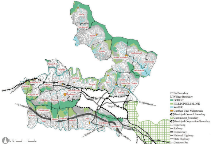
Talegaon Growth Centre’s terrain is gradually sloping towards the south where Indrayani River is located. Andra Dam, Indrayani River and southern ridge (forest zone) split Talegaon GC into three parts.
Indrayani River flows through the Growth Centre in addition to its tributaries, with Sudha River being the major one. In contrast, the Pawana River flows along the southern edge of the Growth Centre. Forest areas are situated on the East, West and North side of the Growth Centre.
Figure 27.1: Location and Physiography
Chapter 27 Growth Centre: Talegaon
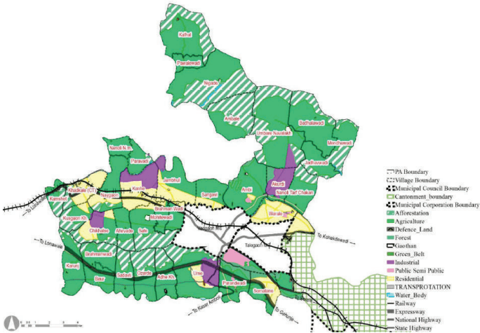
Talegaon Growth Centre includes part of RP 1997 Sectors such as Sector NOR, J and Maval Zone Plan. Residential Development has been majorly proposed to the along old Mumbai – Pune Highway and partially along expressway.
Industrial area is also proposed at Kanhe, Urse, Akurdi and Chikhalse village.Chikhalse village has been earmarked for industrial purpose with a view to provide job opportunities to local people.
RP 1997 proposed widening of Mumbai - Pune highway i.e. 60 m. with 45 m Green Belt on either side for tree plantation. , ensuring a 75 m setback from the centreline of the highway. (No construction activity is allowed in Green Belt), 40M wide diversion through Khadakale, Kusgaon Kh. And Chikhalse and Ahirwade and further connecting to the Highway near C.R.P.F. in Talegaon Growth Centre and 40 M wide Northern and Southern diversion.
Figure 27.2: RP 1997 Zoning Map
Table 27.1RP 1997 Area Statement
Land use category
Area (ha)
Proportion of Total Devel-oped Area (%)
Proportion of Total Area (%)
Residential
2103.87
53%
10%
Gaothan
101.86
3%
0.5%
Industrial
931.91
23%
5%
Public - Semi Public
186.33
5%
1%
Transport
653.61
16%
3%
Total Developable Area
3977.6
100%
19%
Agriculture
10654.91
52%
Forest
381.85
2%
Defence
53.56
0.3%
Afforestation
4922.45
24%
Green Belt
178.13
1%
Waterbody
325.51
2%
Total Non Developable Area
16516.45
81%
Total
20494.05
100%
Existing Land Use
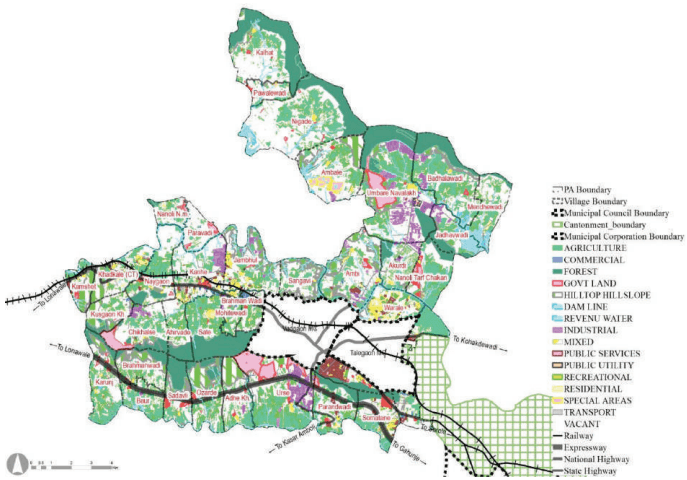
Industrial developments have been flourishing in the Growth Centre along the Mumbai-Bangalore National Highway and Yashwantrao Chavan Expressway due to its proximity with PMC and Chakan MIDC. Agriculture (24.76%), Forest (13.37%) and Hilltop Hill slope (7.82 % ) shares maximum land uses in the GC.
Talegaon Growth Centre’s total area is about 20491 Ha., out of which 11% land is developed. It includes residential, commercial, industrial and allied uses. Public semi-public use (about 4.59%) is the largest among developed areas, including major educational institutess such as the National Institute of Post-Harvest Technology, DY Patil Engineering College, Heritage Residential School, Empress International School. Developed areas are clustered at villages such as Khadkale, Kanhe, Jambhul, Ambi, Warale and Somatane.
Figure 27.3: Existing Land Use Map
Chapter 27 Growth Centre: Talegaon
Table 27.2Existing Land Use Area Statement
Land use category
Area (ha)
Proportion of Total Devel-oped Area (%)
Proportion of Total Area (%)
Residential
500.44
19%
2.44%
Gaothan
99.15
4%
0.48%
Commercial
89.04
3%
0.43%
Industrial
498.75
19%
2.43%
Public semi Public
939.77
35%
4.59%
Transport
521.38
19%
2.54%
Mixed use
17.70
1%
0.09%
Public Utilities
22.22
1%
0.11%
Total Developed Area
2688.45
100%
13.12%
Agriculture
5073.60
24.76%
Forest
2739.47
13.37%
Hilltop Hill slope
1603.55
7.82%
Special areas
120.48
0.59%
Recreational
49.74
0.24%
Water Body
684.11
3.34%
Vacant Land
7534.52
36.76%
Total Non-Developed Area
17805.46
86.88%
Total Area
20493.92
100%
Key Challenges
Traffic congestion along NH-48 and NH-548D, as no bypass developed
Absence of sewerage, storm water drainage and solid waste management sites.
Industrial growth has been depleting the air quality in the region, considering the rapid unorganized urbanization of Talegaon GC.