Khed Rajgurunagar is envisioned as a Commuter Town. It leverages upon land availability and a potential for expansion required around Rajgurunagar municipal council and Chakan municipal council. Due to proximity to major employment node like Chakan , good connectivity and rapid population growth and spill over to Rajgurunagar MC; Khed Rajgurunagar growth centre will be an ideal location to reside there. Chakan Municipal Council services having potential to develop comprehensively planned residential townships/ housing schemes to support industrial workers of Chakan and ongoing private industrial cluster (Khed SEZ). Good accessibility by Pune-Nashik Highway and proposed Metro line from PMC and PCMC as per CTTS study. With proposed Pune-Nashik High Speed Rail and Crescent railway, it connects industrial clusters of Talegaon, Chakan and Shikrapur.
Growth Centre Area
4941.4 Ha.
Population
79,186 (2041); 64,260 (2031), 31251 (2011)
Net Population Density
125 PPH
Resident Workforce
35,783
Employment
38,950
Households
19,431(2041)
Proposed Zones
Residential (1075.33 Ha.), Industrial and Logistic zone (255.75 Ha.), Commercial (36.12 Ha.)
Promote residential development around Rajgurunagar council and along Pune-Nashik Highway (NH60).
Consolidate industrial zone around existing industry and industrial zone proposed in RP 1997;
Open up residential zone around proposed industrial zone, within 500m to promote work live concept.
Develop a grid network of secondary and tertiary roads for a smooth movement within the Growth Centre.
Establish green and blue network by designating green belts along Bhima and Bhama rivers and their tributaries.
Promote self-sufficient town by proposing required amenities and utilities for the projected population.
Pune-Nashik High Speed Rail
Proposed Talegaon- Urali Kanchan Crescent Railway
Metro line along NH 60 with Metro Station at Waki Kh.(Approx. 1 km)
30 m. bypass roads to Pune-Nashik Highway.
Two Town Centres at Waki Kh. and Santoshnagar (5.72ha)
Town Park at Chandoli (0.84 ha)
Bio-diversity Park in Santoshnagar and Shiroli at hillocks.
Proposed Town Planning Scheme of mixed use in Waki Kh.
Public Housing at Shiroli and Dhorewadi (3.79 Ha.)
29.2Existing Situation Analysis
Khed-Rajgurunagar Growth Centre comprises of 12 villages from Khed Taluka as below:
Area of the Growth Centre is about 4941 Ha. and its population was about 31,251 as per Census 2011. Key strength of the Growth Centre is its proximity to Rajgurunagar and Chakan Municipal Council. The area is in vicinity to industrial hubs at Talegaon, Chakan and Shikrapur.
Location & Connectivity
Khed Rajgurunagar is divided into two parts by Pune- Nashik Highway (NH-60), passing through Rajgurunagar Council. Chakan Municipal Council lies adjacent to Khed Rajgurunagar on South. Khed Rajgurunagar Council is situated in the centre of the growth centre. Chakan MIDC is approximately 11 Km. away. The approximate distance of Khed Rajgurunagar is 31km from PCMC and 43 km from PMC. Its future connectivity is likely to be strengthened with mass transit like metro, rail and high speed rail. High speed railway passes through village Holewadi and the station in Holewadi is 3.5kms away from Rajgurunagar council, connected by SH 103. Crescent Railway joining Talegaon and Urali-Kanchan goes via Waki Khurd village. A railway station is proposed in the village,which is near Chakan Municipal Council. This facilitates as a connection between Talegaon council and Chakan council by rail.
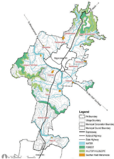
Bhima and Bhama rivers flow West - East through the Growth Centre. Bhima River flows centrally along the boundary of Rajgurunagar council, while Bhama River flows from the southern part of the Growth Centre. Two Chas-Kaman canals flow from southern side of Rajgurunagar Council. Hilly topography is observed in the northern side of the Growth Centre. Some small hillocks are spread across the Growth Centre.
Figure 29.1: Location & physiographic
Chapter 29: Growth Centre: Khed Rajgurunagar
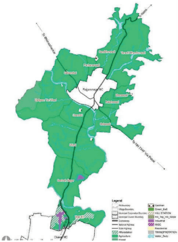
Figure 29.2: RP 1997 Zoning Map
Regional Plan (RP) 1997 Analysis
Khed Rajgurunagar is a part of Sector M and Pune District. Some part of Waki Khurd village was in Chakan and surrounding area and remaining part is in Pune district of ‘Sanctioned Regional Plan Pune 1997’.Major part of this area was not included in Growth center of Pune District approved Regional Plan.Gaothan extension of 500m in agriculture zone. Industrial zone was proposed in Santoshnagar and WakiKh. Afforestation zone was proposed in Waki kh.
Table 29.1RP 1997 Area Statement
Land use category
Area (ha)
Proportion of Total Devel-oped Area (%)
Proportion of Total Area (%)
Gaothan
25.67
33%
0.52%
Industrial
38.08
49%
0.77%
Transport
14.30
18%
0.29%
TotalDevelopableArea
78.05
100%
1.58%
Agriculture
4429.30
89.57%
Afforestation
118.32
2.39%
Forest
175.92
3.56%
WaterBody
143.37
2.90%
TotalNon-DevelopableArea
4866.93
98.42%
Total
4944.98
100%
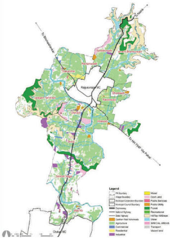
Agriculture (about 44%), Vacant land (about 27%), and Hill Top Hill Slope and forest (about 15%) dominates existing landuse composition of the Growth Centre. Non-developable areas (about 90%) includes vacant land, agriculture, forest, hill top hill slope, special areas, recreational, and water bodies conveys environmental sensitivity of the planning area.
In Khed Rajgurunagar, agriculture is the dominant land use, with maximum share of 44%.According to RP- 1997, the khed Rajgurunagar planning area is under agriculture zone. According to ELU, Residential area is developed along NH 60 and mostly in surrounding area of Rajgurunagar Municipal Council. Sporadic development is observed around gaothans. Area under residential is approximately 2% which is very less. Most of the remaining part is under agriculture.
Due to Government ITI and government lands, ELU shows approx. 3% area is under public –semipublic zone.1.7% area is marked under industrial like Tata International DLT, Tata Motors warehouse, Cameron Industrial park, phase 5, etc. Implementation of industrial zone proposed under RP 1997, can be seen at Waki Kh. Industrial development is also seen in consolidated format in villages like Santoshnagar and Chandoli.
Figure 29.3: Existing land use map
Table 29.2Existing land use area statement
Land use category
Area (ha)
Proportion of Total Devel-oped Area (%)
Proportion of Total Area(%)
Residential
99.38
20.2%
2.01%
Gaothan
13.17
2.7%
0.27%
Commercial
33.7
6.9%
0.68%
Industrial
81.86
16.7%
1.66%
Chapter 29: Growth Centre: Khed Rajgurunagar
PublicsemiPublic& GovernmentLand
143.46
29.2%
2.90%
Transport
98.41
20%
1.99%
Mixed
0.67
0.1%
0.01%
PublicUtilities
20.55
4.2%
0.42%
TotalDevelopedArea
491.2
100%
9.94%
Agriculture
2168.5
43.89%
Forest
287.12
5.81%
HilltopHillslope
460.78
9.33%
Specialareas
1.13
0.02%
Recreational
4.64
0.09%
WaterBody
198.37
4.01%
Vacantland
1329.5
26.91%
TotalNon-DevelopedArea
4450.1
90.06%
Total
4941.3
100%
Key Challenges:
Sporadic development in Khed Rajgurunagar growth centre.
Traffic congestion at NH 60.
Absence of social infrastructure.
29.3Proposed Role & Strategies:
Khed Rajgurunagar Growth Centre is envisioned as a Commuter Town leveraging upon following assets;
Land availability and a potential for expansion required around Rajgurunagar and Chakan Municipal Councils.
Good accessibility by Pune- Nashik Highway and proposed Metro line from PMC and PCMC as per CTTS study.
Good accessibility by proposed Pune-Nashik High Speed Rail and Crescent railway, to the industrial clusters of Talegaon, Chakan and Shikrapur as well as PMC.
Socio - economic Projections
Based on the URGD method, projected population for the Growth Center would be as below:
Table 29.3Population Projections
Village
2011
2018
2031
2041
Chandoli
3363
4,934
7,071
8,770
Dhorewadi
797
1,008
1,108
1,124
Holewadi
2576
4,053
5,707
6,905
Pacharnewadi
777
834
898
940
Rakshewadi
5113
6,618
10,497
14,501
Sandbhorwadi
1587
1,877
2,078
2,163
SantoshNagar( N.V).
1578
2,123
2,985
3,583
Satkarsthal
3450
9,136
13,677
16,161
Shiroli
5255
7,007
9,886
12,400
VadgaonTarfKhed
2331
2,532
2,772
2,935
VarchiBhamburwadi
1915
2,024
2,123
2,189
WakiKh.
2509
3,375
5,458
7,515
Total
31251
45520
64260
79186
The projected resident workforce based on the projected population through the URGD method is 35,783. Considering the proposed economic activities of all the growth centres, employment distribution was proposed based on the envisaged sectoral split for that Growth Centres. Accordingly, the employment to be generated for the Growth Centre for the year 2041 is estimated to be 38,950. The proposed residential density is about 125 PPH (12,500 persons/sq km).
For the planning of sustainable and self-sufficient infrastructure and amenities distribution with proposed population density, the Growth Centre is considered as a single sector.
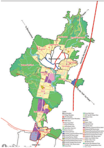
Proposed zoning would determine efficient use of land for the next 20 years. Proposed zoning plan is an output of existing landuse and physical conditions analysis; understanding of most pressing issues of the Growth Center; local knowledge of the place; and deployment of five planning goals and allied physical planning strategies.
Summary of proposed zoning area statement is presented below:
Chapter 29: Growth Centre: Khed Rajgurunagar
Figure 29.4: Proposed zoning map
Table 29.4Proposed zoning area statement
Land use category Area (ha)
Proporti oped Are
on of Total Devel- Proporti a (%) (%)
on of Total Area
Residential
1075.33
59.61%
21.75%
Gaothan
12.52
0.69%
0.25%
Commercial
36.12
2.00%
0.73%
Industrial
190.55
10.56%
3.85%
Logistic
65.20
3.61%
1.32%
PublicsemiPublic
67.63
3.75%
1.37%
Transport
349.39
19.37%
7.07%
PublicUtilities
7.34
0.41%
0.15%
TotalDevelopableArea
1804.07
100%
36.49%
Agriculture (G1)
2018.08
40.82%
Forest
410.23
8.30%
Afforestation
26.78
0.54%
HilltopHillslope
345.37
6.99%
GreenBelt
71.58
1.45%
Recreational
41.30
0.84%
WaterBody
226.31
4.58%
TotalNon-DevelopableArea
3139.66
63.51%
Total
4943.73
100%
Translating Goals into the Plan
Proposed zoning ensures that the sectoral development goals are clearly conveyed through it. For brevity, proposed sectoral goals and their corresponding physical planning strategies are mentioned in figure below:
Table 29.5Goals and physical planning strategies
Goals
Development Sector addressed
Physical planning strategies
Prudent
Employmentandhousing
Work -LiveHubs
Convenient
Roadsandmasstransport
MovementLattice
Resilient
Environmentprotection
Green -Blueconnectors
Efficient
Infrastructureandutilities
Decentralisedresourcemanagement
Self -sufficient
Socialfacilities
WalkableNeighbourhoods
Following sections elaborate translation of sectoral development goals into the zoning plan.
Prudent: Work-Live Hubs
‘Prudent’ goal would be addressed by Work-live concept that implies working closer to homes. As explained in proposed vision framework, in context of metropolitan regions it is assumed that maximum 30% of the resident workforce would be employed within a suburb/ town where they reside.
For Khed Rajgurunagar Growth Center, work-live concept is applied by
Due to Chakan MIDC (approx. 11 Km. away) and small scale industries at Waki - Khurd ,surrounding area is developed upto 10% approximately.
Designating residential zones within 500 m around industrial, Regional Centre and commercial zones to minimise work related trips for at least 30% of the resident workforce Due to strong connectivity by NH 60, residential nodes are proposed along NH 60 and surrounding of Rajgurunagar municipal council at Rakshewadi, Satkarsthal, VadgaonTarf Khed, Pacharnewadi, Dhorewadi, Chandoli, Shiroli, Santosh Nagar and Waki Khurd.
An additional Industrial zone is proposed along NH 60 at village Chandoli, Santoshnagar and Waki Khurd, Southern part of the Growth Centre is expanded as per the Existing land use .The industrial nodes are well connected through proposed Pune Nashik Highway, High-speed railway, proposed crescent railway line, and proposed PMR metro line.
The Residential zone is in proximity to NH 60 , proposed Metro Depot and Railway station.
The proposed employment for planning area for 2041 is 38,950 employees which is 49.18% of the projected population. The proposed net residential density is about 125 ppl/ ha (12500p/sq km) in order to promote the Work-Live Hub concept.
Two town centres are proposed. One is at Santoshnagar and and another one is at Waki Khurd, invicinity to proposed Cresent railway station.
Logistic zone / Industrial Zone:
The total logistic land use requirement of the Study Area is estimated to be 2020Ha. considering projected demographics and area requirement of 55 sqm built-up area per person. 200 Ha. of this estimated area is anticipated in Khed Rajgurunagar Growth Centre. However, considering the existing trend of the GC, the prevailing trend of warehousing and supplementary industries and the proposed strategic infrastructure projects, logistic use is proposed over 65.20 Ha.
Chapter 29: Growth Centre: Khed Rajgurunagar
Considering proposed industrial zones in sanctioned RP at sporadic locations along NH 60 and existing industrial development, total 255.75 Ha. of industrial zone is proposed along NH 60.
Land requirement for the residential zone is estimated based on a net residential density of 125 PPH. Further, 45% add-on is considered to account for amenity (15%), open spaces (10%) and roads (20%). Accordingly, the total gross area required for the projected GC population of 79,186 by 2041 is estimated to be 920 Ha, whereas the residential use is proposed covering 1075.33 ha.
As per work-live hub concept, consolidated residential zone is proposed. Beyond the proposed residential zone additional residential zone is proposed for the expansion of gaothan periphery within the growth centre. Total proposed residential zone covering 1075.33 Ha. Majority of residential zone lies within 500 metres from commercial and industrial zone fostering a work-live environment. Town Planning Scheme is proposed in Waki Khurd ,a combination of residential, Industrial, Logistic and PSP zone remarking a work live relationship.
Land requirement for the commercial zone is estimated based on URDPFI guidelines, i.e. 0.6 ha per 1,000 population. Add on of 30% is considered to account for roads (15%), open spaces (10%) and amenities (5%). Accordingly, the total commercial zone requirement for the Study Area is estimated to be 48Ha. 36.12 Ha. from this area is proposed in the Growth Centre such that equitable distribution of commercial activities is facilitated.
Two cardinal commercial nodes are proposed at Holewadi and Santoshnagar , one at junction of SH 103 and Pune – Nashik High Speed railway station in Holewadi and second serving residential zone of Santoshnagar. Two town centres are proposed within growth centre at an integrated commercial node with a Metro station, Multi-modal Hub and Railway Station at Waki Kh. And another is proposed in Santoshnagar along NH 60.