Few aberrations taking place around Chandigarh’s Master Plan area and the immediate periphery of the Union Territory (UT) have jeopardized its ‘Future Plan’, forcibly weakening its opportunity to;
i. Plan in the context of its region
ii. Plan comprehensively (with minimal friction) within new areas outside the UT boundary, for allowing growth for future residential and work areas
iii. Check undesirable land uses and activities in the periphery
iv. Provide, operate or maintain world class infrastructure services due to constraints of land
v. Enhance the aesthetics, design and urban form compatible with laid down principles
vi. Maintain the integrity of its heritage
vii. Integrate all infrastructure services including transport in the Capital City and its extensions to benefit the agglomeration
viii. Permit inclusive growth in both urban & rural villages.
The aforementioned factors appear a formidable challenge for promoting future planned growth and development of Chandigarh Union Territory which call for innovative solutions to be evolved for integrating the development within Chandigarh and adjoining areas falling in the States of Punjab and Haryana.
1.4 A CHRONOLOGICAL ACCOUNT OF THE EXTERNAL FACTORS THAT HAVE BECOME A CHALLENGE FOR CHANDIGARH’S GROWTH ARE:
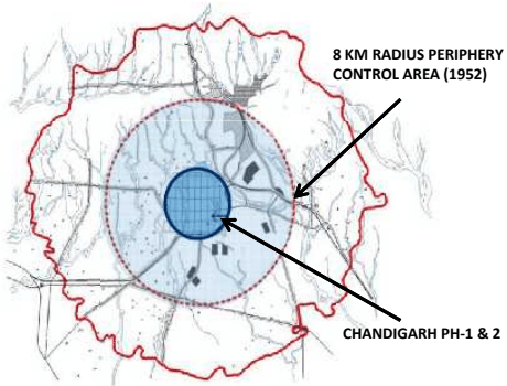
a) 1952- Creation of an 8 km radius agricultural belt in the periphery of Chandigarh through the PERIPHERY CONTROL ACT, 1952 (Refer MAP 4). The purpose was to prevent unregulated development around the master plan, maintain a clear ruralurban dichotomy and provide for planned future extension of the city.
MAP 4 CREATION OF 8 KM PERIPHERY CONTROL AREA
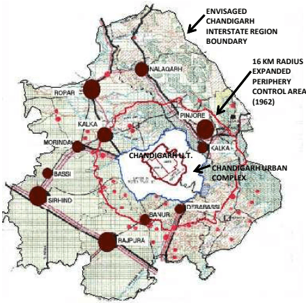
1962- Establishment of the Army Cantonment, Air Force Station and, the township of Hindustan Machine Tools (HMT) with their offices and other facilities. Extension of the Periphery Control Area to a 16 km radius (Refer MAP 5).
Map 5 Creation of 16 KM Expanded Periphery Control Area
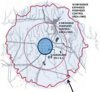
16 KM RADIUS EXPANDED PERIPHERY CONTROL AREA (1962)
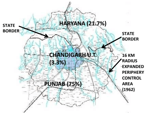
1966 -Reorganisation of the State of Punjab into States of Haryana & Punjab with Chandigarh functioning as the State Capital of both. Creation of the Union Territory of Chandigarh in 70 sq km as Capital City and 26 adjoining villages in 44 sq km. Out of the 1315 sq km extended periphery, 1021 sq km of the Periphery Control Area went to Punjab, 295 sq km to Haryana with remaining area
of 114 sq km forming the UT with the Capital City for all its present and future needs.(Refer Map 6) Out of this defined new periphery it was clear that Chandigarh got just 3% land of the original periphery.
MAP 6 DISTRIBUTION OF 16 KM PERIPHERY CONTROL AREA BETWEEN PUNJAB, HARYANA & UT OF CHANDIGARH
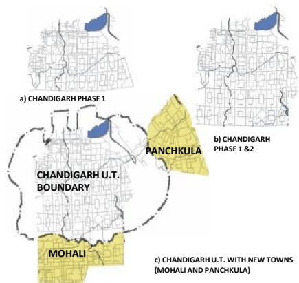
d) Post 1966 - Establishment of Mohali township of Punjab in periphery covering 5500 acres and, Panchkula township of Haryana covering 5000 acres. Townships in the periphery emerged as a result of development pressures observed in the form of unregulated growth. (Refer Map 7)
MAP 7 INITIAL NEW TOWNSHIPS IN CHANDIGARH’S PERIPHERY
e) 1975 - Constitution of a high powered Co-ordination Committee chaired by Secretary, Ministry of Urban Development, Government of India and the Chief Secretaries of both the adjoining states and the Chief Commissioner of UT Chandigarh to resolve matters pertaining to developments around Chandigarh and to suggest measures for not compromising the original intent of the Chandigarh Plan.
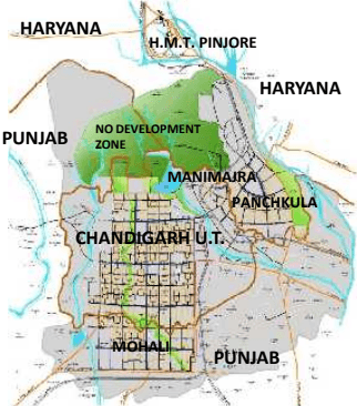
f) 1977 - Preparation of the Regional Plan for Chandigarh’s immediate region. Called the ‘Chandigarh Urban Complex’ (CUC) Plan covering 330 sq km, it comprised of Chandigarh Union Territory (UT), parts of Mohali and its adjoining 27 villages and parts of Panchkula and 23 villages.
The CUC Plan was approved by the Co ordination Committee. The area of this plan was entirely within the originally conceptualised 8km radius periphery control belt (Refer Map 8). The CUC Plan declared the area north of the Capitol Complex as ‘No Development Zone’.
MAP 8 CHANDIGARH URBAN COMPLEX (1977): DEVELOPMENT OF TOWNSHIPS
g) 1984-Review of the Chandigarh Urban Complex (CUC) Plan and preparation of a new ‘Interstate Regional Plan 2001 to cater to a population of 25 lakhs distributed in 7 categories of settlements . The Plan revived the 16 km belt of the periphery, assigned 50% population to Chandigarh UT and the remaining to the periphery area in Punjab and Haryana. (Refer Map 9).
MAP 9 STRUCTURE PLAN: INTERSTATE REGIONAL PLAN (1984)
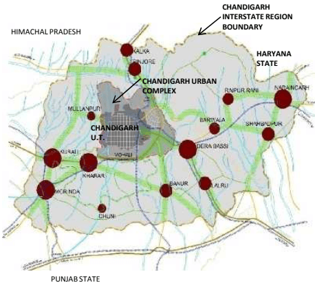
h) 1999-Preparation of the ‘Chandigarh Interstate Metropolitan Regional Plan’ (CISMeR Plan) which enlarged the territory of the Plan to a 50km radius periphery control area incorporating Chandigarh UT and 10 tehsils from Punjab, Haryana and Himachal Pardesh. Satellite towns were conceptualized to take the pressure off Chandigarh. No approval was accorded to this Plan. (Refer Map 10)
MAP 10 CHANDIGARH INTERSTATE METROPOLITAN REGION PLAN
MAP 11 GMADA REGIONAL PLAN 2056
i) 2008-Notification of the ‘GMADA REGIONAL PLAN 2056’ by Punjab covering 1021 sq km , creating 7 Integrated Economic Hubs consisting of a huge agglomeration in absolute continuity to the Chandigarh UT and containing major drivers of economic growth (Refer Map 11). The area north of Chandigarh and abutting the Capitol Complex created by Le Corbusier and consisting of the village settlements Naya Gaon & Kansal has also been notified as a Nagar Panchayat by the Punjab Government under whose jurisdiction the land falls.
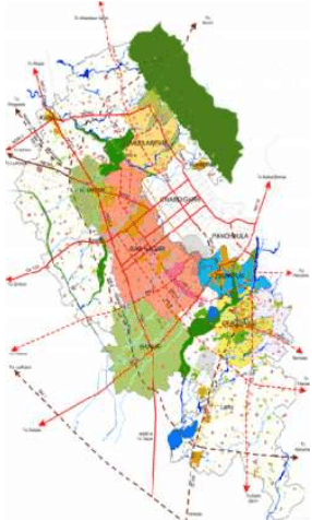
In a similar manner, the Haryana Government has planned 5 settlements, (Refer Map 12). Of these, Panchkula and the ‘Panchkula Extension-1’ across river Ghaggar stand fully developed; Panchkula Extension- 2 , Shree Mata Mansa Devi Complex comprising of 1550 acres, close to Sukhna Lake and Kalka-Pinjore Urban Complex are under development.
MAP 12 HARYANA DEVELOPMENT PLAN
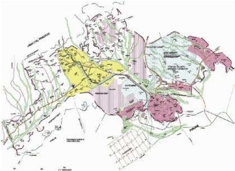
k) It is clear from the above sequence of events that actions committed in the periphery have left very limited opportunity for Chandigarh to achieve its Mission of a Plan commensurate with the ‘EDICT OF CHANDIGARH ’ and principles laid down by Le Corbusier (Annexure P II).