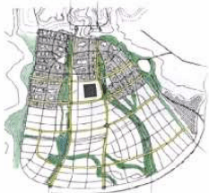
In March 1948, the then Government of Punjab in consultation with the Government of India approved the site for the new capital for the state. The first team of architects engaged for planning and designing the city was lead by American planner Albert Mayer and architect Mathew Nowicki. The team prepared the Master Plan and detailed out the super block which constituted the basic module of city planning (Refer MAP 1). The Master Plan was fan shaped keeping in view the profile of the site. Curvilinear roads defined the circulation pattern punctuated by green belts. Due to the sudden demise of architect Mathew Nowicki in an air crash, second team of architects lead by Le Corbusier (also called Charles Edouard Jeanneret), Pierre Jeanneret, Jane B Drew and Maxwell Fry took over. Le Corbusier designed an iconic city, fulfilling not just a utopian agenda, but reflecting concepts of ‘modernism’ movement that arose in Europe but took root here too.
The city reflects the forceful personality of Le Corbusier in many tangible ways creating modular, geometric and cubist idioms using ‘brute’ materials yet the sub text was drawn from nature (the head/ lungs / heart / limbs ) and incorporated the essentials of site / climate/culture/tradition.
MAP 1 ALBERT MAYER ‘S PLAN FOR CHANDIGARH
He ensured that the human resource inputs into the Capital Project would be of impeccable technical and moral standards forging philosophical underpinnings and as rightly observed by an expert , likened Chandigarh ‘to an enterprise whose value will soon be proclaimed all over the world’ and to whom ‘the city was a sign of harmony born of good intentions, struggles, patience and perseverance …..and a spirit of strength and severe simplicity ‘.
1.2The Original Plan
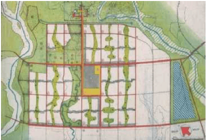
The original plan was divided into a grid of 30 sectors with the Capitol Complex as well as the Civic Centre its focal points. Sector 17 was designed as the Central Business District and a greenbelt at the centre ran north east to south west. Wide roads planned in a systematic hierarchy provide structure to the city which has well planned facilities. Landscaped green avenues give it amenity value. (Refer MAP 2).
MAP 2 LE CORBUSIER’S PLAN (PHASE I) WITH ITS GREEN LUNGS
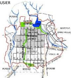
The First Phase (now deemed the city’s ‘Historic Core’) was designed for 150,000 in low rise plotted development. Phase Two from sector 31 to 47 for the remaining targeted 350,000 was with 4-storeyed apartments for government employees with an increase in the ratio of smaller plots/lesser open areas / nearly 4 times increase in density. The original concept included redensification of Phase I in order to accommodate population of the city growing beyond design population of 5 lakh without changing the character of the city and quality of life. However, no details with regard to redensification mechanism are available except a letter containing two sketches giving the basic approach to achieve the redensification of Phase I.(Annexure P 1 Letter Dated 4th May,1957 and Annexure P IA Typed version of the letter )
MAP 3 -CHANDIGARH (PHASE I & II ) AS CONCEPTUALIZED BY
However, with the coming up of Mohali the new town on the south of Chandigarh in the post reorganisation period, the gap between Phase II and Mohali was planned as Phase III of Chandigarh in order to integrate and promote planned development and continue the sectoral grid and the development of the land falling between Phase II and Mohali. Phase III comprises of ‘Group Housing Schemes’ and four storeyed flats built by the Chandigarh Housing Board and cooperative house building societies instead of plots resulting in higher densities.
Over a period of time, city development has now been extended to the area earlier covered under the Periphery Control Act to meet the emerging needs of development involving setting up of Information Technology Park, rehabilitation of slum dwellers, dairy farm, solid waste management, tourism, transport, sports and recreation etc.
1.5Constitution of Expert Committee for Preparation of CMP 2031 for UT Chandigarh:
Having understood the constraints facing planning and development, the Chandigarh Administration constituted an Expert Committee for preparation of draft Plan of UT Chandigarh consisting of 11 members.
The Committee was mandated to keep in mind and adhere to various decisions of the Coordination Committee headed by the Secretary, Ministry of Urban Development, GOI and directions of the Hon’ble High Court in CWP No. 4252 of 2008
on (i) the Preparation of a Master Plan for the remaining Periphery Area in the UT of Chandigarh within the scope of the Punjab New Capital (Periphery) Control Act 1952 as also the 73rd and 7 4 t h Constitutional Amendments; (ii) Preparation of a Regional Plan for the tri-city of Chandigarh/ Mohali/ Panchkula for guiding future growth in the periphery; (iii) Preventing any further implementation of ad-hoc projects in the periphery till the formulation of the Master Plan as above. The Master Plan Committee was constituted in December 2009 and expanded in May 2010 (Annexure P III). Note: (ii) pertains to an Interstate Coordination Committee.
1.6 Study of Ongoing Policies and Projects of the Chandigarh Administration:
Whilst the exercise was considered urgent, the ongoing policies and projects were required to be accorded due consideration in the new plan. Some of these were (i) Preparation of the Mass Rapid Transport (MRTS) Plan; (ii) issues of ‘shifting’ selected activities (grain market/slum rehabilitation etc.) (iii) demand for enhanced coverage by coal depots/building material stores/marla houses/redensification for Phase I & II, preparation of a heritage plan, etc.
1.3Challenges for the ’ Future Plan ‘
Few aberrations taking place around Chandigarh’s Master Plan area and the immediate periphery of the Union Territory (UT) have jeopardized its ‘Future Plan’, forcibly weakening its opportunity to;
i. Plan in the context of its region
ii. Plan comprehensively (with minimal friction) within new areas outside the UT boundary, for allowing growth for future residential and work areas
iii. Check undesirable land uses and activities in the periphery
iv. Provide, operate or maintain world class infrastructure services due to constraints of land
v. Enhance the aesthetics, design and urban form compatible with laid down principles
vi. Maintain the integrity of its heritage
vii. Integrate all infrastructure services including transport in the Capital City and its extensions to benefit the agglomeration
viii. Permit inclusive growth in both urban & rural villages.
The aforementioned factors appear a formidable challenge for promoting future planned growth and development of Chandigarh Union Territory which call for innovative solutions to be evolved for integrating the development within Chandigarh and adjoining areas falling in the States of Punjab and Haryana.
1.4 A CHRONOLOGICAL ACCOUNT OF THE EXTERNAL FACTORS THAT HAVE BECOME A CHALLENGE FOR CHANDIGARH’S GROWTH ARE:
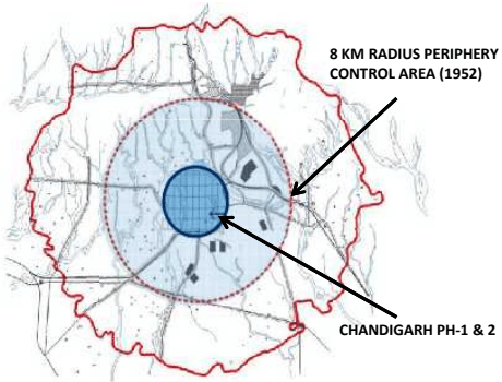
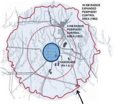
a) 1952- Creation of an 8 km radius agricultural belt in the periphery of Chandigarh through the PERIPHERY CONTROL ACT, 1952 (Refer MAP 4). The purpose was to prevent unregulated development around the master plan, maintain a clear ruralurban dichotomy and provide for planned future extension of the city.
MAP 4 CREATION OF 8 KM PERIPHERY CONTROL AREA
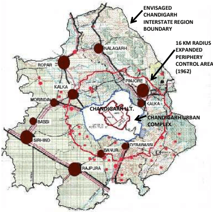
1962- Establishment of the Army Cantonment, Air Force Station and, the township of Hindustan Machine Tools (HMT) with their offices and other facilities. Extension of the Periphery Control Area to a 16 km radius (Refer MAP 5).
Map 5 Creation of 16 KM Expanded Periphery Control Area
1.7Master Plan Meetings for Feedback and Deliberations:
The committee held a number of meetings and deliberated on matters concerning both day to day issues as well as issues pertaining to long term planning. Committee also interacted with various stake holders including, trade and commerce, village panchayats, groups representing whole sale markets, NGOs, resident welfare associations, municipal councillors, industrialists, educationists, etc. in order to have first hand feed back of the city and problems/expectations visualized by the city residents.
In addition, all the departments of the Chandigarh Administration were asked to give their vision and proposals for meeting the immediate and future needs of the city relating to their operational areas. Meetings were also held with the representatives of the Government of India and State Governments of Punjab, Haryana in order to synergise the interstate development so as to integrate the issues related to traffic and transportation, heritage, landuse, services etc.
RITES also made presentations regarding their proposals for preparing the Comprehensive Mobility Plan for Chandigarh Urban Complex and improving the transport infrastructure in the city. While evolving the Chandigarh Master Plan 2031, the proposal regarding Mass Rapid Transport System was studied in detail. In February 2010, RITES presented their proposal for the MRTS to a joint group representing the tri-city concerns.
Some issues deliberated by the Committee included preservation of original concept of the plan , maintaining the basic character of the town, preserving ecology and environment, heritage status of the city, protecting the Sukhna Wild Life Sanctuary, protecting the catchment area of Sukhna Lake, promoting sustainable urban development, ongoing development projects, available vacant land, growth and development of villages falling within and outside the sectoral grid, informal residential and commercial sector, developments in the neighbouring towns and future needs of growth and development of the city.
In addition, the Master Plan Committee considered in detail the following:
• Pedestrian friendly measures and cycle tracks and walk trails
• Revitalization of the City Centre & Sub City Centres
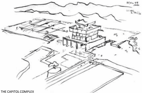
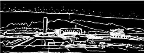
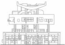
• Completing unfinished projects of Le Corbusier
• Improving aesthetic/urban design/art related aspects
1.10Sustainable Development
Incorporating climate change and sustainable development measures
A degrading ecology of the northern lower Himalayan Shivaliks as well as the seasonal rivulets on its eastern and western boundary (i.e. Sukhna Choe and Patiali Ki Rao)
The pressures resulting from Sustainability vs Development issues (Green Agenda vs Real Estate development)
Integrating tourism in Chandigarh’s future economy due to its intrinsic assets of architecture, urban design, landscape, proximity to the scenic and unique backdrop of the Himalayas alongwith creating new opportunities for ecological health and wellness, recreational etc tourism.
Issues born of periphery region development and integration of Infrastructure Services such as transport, water supply, storm water drainage, solid waste management, sanitation etc. sustainability
Addressing the issues of a bipolar city consisting of the very rich and the very poor.
FIGURE 1: Views of unfinished projects of Le Corbusier
THE CAPITOL COMPLEX
VIEW OF THE GOVERNOR’S PALACE
VIEW OF THE MUSEUM OF KNOWLEDGE
1.11 APPROACH TO MASTER PLAN PREPARATION
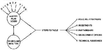
The Chandigarh Master Plan 2031 aims to provide an integrated version of an urban community’s diverse perspectives through a unified vision for future development. The on ground reality, when compared to the vision, sets the agenda for action and onward movement. This entails formulating and sequencing policy initiatives, development strategies, civil society partnerships and investments.
1.9An Overview and Guiding Principles for Comprehensive Chandigarh Master Plan 2031 (CMP 2031)
Chandigarh has been politically and administratively symbolic of the aspirations of a newly independent nation reflected in a planned capital city imbued with eminence and personality of its planner Le Corbusier. The last six decades have seen it grow at a pace which is now challenging its contemporariness as envisaged by Le Corbusier, yet giving impetus to growth, some modern some organic in its peri urban zone. This has involved transformation of its socio economic, natural and built environment. The framework for guiding its future growth shall remain constrained by an imposed boundary due to re-organisation of states in 1966.
The proposed plan respects its historical legacy and optimises on its constraints of land. The plan is an attempt to redeem an efficient circulation network and extensive lung space as well as the scenic backdrop of the Shivalik Hills against which lies the dramatic Capitol Complex given its due place of pride. The plan provides a useful base for regulating development and building activity in the entire UT of Chandigarh. Thus the reference area for planning constitutes 144 sq km which includes the 60 sectors in the sectoral grid as well as the periphery areas outside it.
The Chandigarh Master Plan 2031 is the first comprehensive plan for developing the city and its periphery within the UT boundary after a spate of adhoc developments impacting its periphery. Some basic postulates for planning need to be emphasised in this context.
i. Chandigarh shall be planned in the context of the region emerging as a result of dedicated efforts of Punjab, Haryana and Himachal Pradesh which surround the city. This postulate accepts the Territorial Development Strategy in the neighbouring region and confines itself to the UT boundary.
ii. Population Dispersion Strategy and the Housing Strategy for CMP 2031 accepts that balanced regional development of the city can be achieved with the New Towns Development within the region.
iii. The Chandigarh Master Plan 2031 envisages that the Metro Plan shall consist of the boundaries of the Sub Regional Divisions of Punjab and Haryana to qualify it for the Integrated Transport and Infrastructure policies as well as the Airport Development Strategy. Together these shall constitute aspects of shared responsibility between Chandigarh UT, Punjab and Haryana.
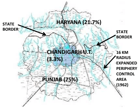
16 KM RADIUS EXPANDED PERIPHERY CONTROL AREA (1962)
1966 -Reorganisation of the State of Punjab into States of Haryana & Punjab with Chandigarh functioning as the State Capital of both. Creation of the Union Territory of Chandigarh in 70 sq km as Capital City and 26 adjoining villages in 44 sq km. Out of the 1315 sq km extended periphery, 1021 sq km of the Periphery Control Area went to Punjab, 295 sq km to Haryana with remaining area
of 114 sq km forming the UT with the Capital City for all its present and future needs.(Refer Map 6) Out of this defined new periphery it was clear that Chandigarh got just 3% land of the original periphery.
MAP 6 DISTRIBUTION OF 16 KM PERIPHERY CONTROL AREA BETWEEN PUNJAB, HARYANA & UT OF CHANDIGARH
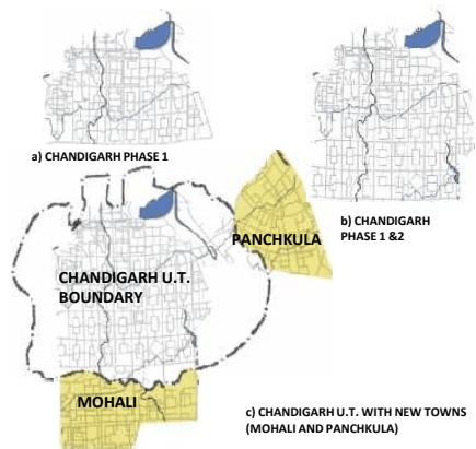
d) Post 1966 - Establishment of Mohali township of Punjab in periphery covering 5500 acres and, Panchkula township of Haryana covering 5000 acres. Townships in the periphery emerged as a result of development pressures observed in the form of unregulated growth. (Refer Map 7)
MAP 7 INITIAL NEW TOWNSHIPS IN CHANDIGARH’S PERIPHERY
e) 1975 - Constitution of a high powered Co-ordination Committee chaired by Secretary, Ministry of Urban Development, Government of India and the Chief Secretaries of both the adjoining states and the Chief Commissioner of UT Chandigarh to resolve matters pertaining to developments around Chandigarh and to suggest measures for not compromising the original intent of the Chandigarh Plan.
f) 1977 - Preparation of the Regional Plan for Chandigarh’s immediate region. Called the ‘Chandigarh Urban Complex’ (CUC) Plan covering 330 sq km, it comprised of Chandigarh Union Territory (UT), parts of Mohali and its adjoining 27 villages and parts of Panchkula and 23 villages.
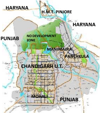
The CUC Plan was approved by the Co ordination Committee. The area of this plan was entirely within the originally conceptualised 8km radius periphery control belt (Refer Map 8). The CUC Plan declared the area north of the Capitol Complex as ‘No Development Zone’.
MAP 8 CHANDIGARH URBAN COMPLEX (1977): DEVELOPMENT OF TOWNSHIPS
g) 1984-Review of the Chandigarh Urban Complex (CUC) Plan and preparation of a new ‘Interstate Regional Plan 2001 to cater to a population of 25 lakhs distributed in 7 categories of settlements . The Plan revived the 16 km belt of the periphery, assigned 50% population to Chandigarh UT and the remaining to the periphery area in Punjab and Haryana. (Refer Map 9).
MAP 9 STRUCTURE PLAN: INTERSTATE REGIONAL PLAN (1984)
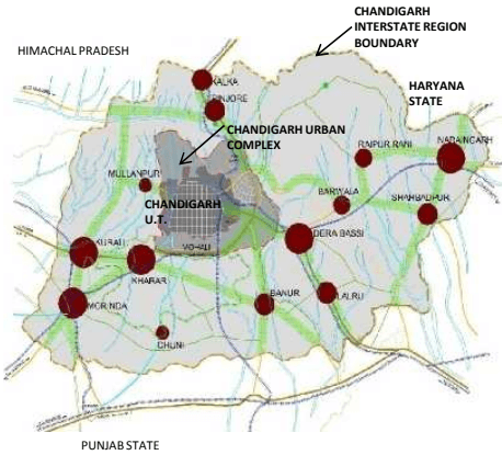
h) 1999-Preparation of the ‘Chandigarh Interstate Metropolitan Regional Plan’ (CISMeR Plan) which enlarged the territory of the Plan to a 50km radius periphery control area incorporating Chandigarh UT and 10 tehsils from Punjab, Haryana and Himachal Pardesh. Satellite towns were conceptualized to take the pressure off Chandigarh. No approval was accorded to this Plan. (Refer Map 10)
MAP 10 CHANDIGARH INTERSTATE METROPOLITAN REGION PLAN
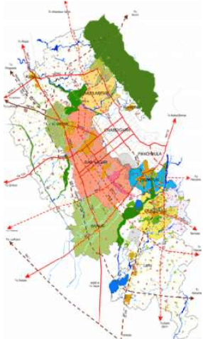
MAP 11 GMADA REGIONAL PLAN 2056
i) 2008-Notification of the ‘GMADA REGIONAL PLAN 2056’ by Punjab covering 1021 sq km , creating 7 Integrated Economic Hubs consisting of a huge agglomeration in absolute continuity to the Chandigarh UT and containing major drivers of economic growth (Refer Map 11). The area north of Chandigarh and abutting the Capitol Complex created by Le Corbusier and consisting of the village settlements Naya Gaon & Kansal has also been notified as a Nagar Panchayat by the Punjab Government under whose jurisdiction the land falls.
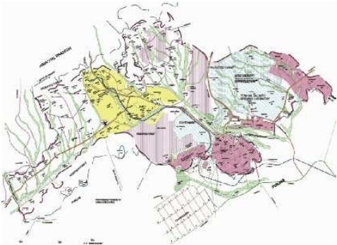
In a similar manner, the Haryana Government has planned 5 settlements, (Refer Map 12). Of these, Panchkula and the ‘Panchkula Extension-1’ across river Ghaggar stand fully developed; Panchkula Extension- 2 , Shree Mata Mansa Devi Complex comprising of 1550 acres, close to Sukhna Lake and Kalka-Pinjore Urban Complex are under development.
MAP 12 HARYANA DEVELOPMENT PLAN
k) It is clear from the above sequence of events that actions committed in the periphery have left very limited opportunity for Chandigarh to achieve its Mission of a Plan commensurate with the ‘EDICT OF CHANDIGARH ’ and principles laid down by Le Corbusier (Annexure P II).
• Actions required for planned village development
• Strengthening Public Transport
• Preventing high rise development in the North dwarfing the Capitol Complex and view of the hills
• Protection of natural rivulets
• Mixed land use development
• Establishment of small, medium and macro Industries
• Issues of through traffic across the city
• Future housing ,institutional areas
• Specific measures for landscaping and greening the city
• Enlarging forest cover and linking existing forests
• Promoting eco-sensitive tourism in villages close to Capitol Complex
• Improving tourism infrastructure and strengthening the city’s economic base
• Measures for inclusive planning including demarcation for night shelters /street vending zones/reception centers/integrating low cost housing for the poor in future housing policies.
• Zero drainage of storm water for large development sites.
• Adaptation of low energy ,locally adaptive materials, labour & technology.
1.8 The Committee also studied the report of the Expert Heritage Committee constituted by the Government of India under the Chairmanship of HE, the Administrator, UT, Chandigarh and the approved letter of the Government of India Dated 23/12/2011. The observations/directions of the Government of India on the said report were also examined .
FIGURE 2: INVOLVING PEOPLE IN PLANNING
The Chandigarh Master Plan 2031 is an effort at developing the above with city, central government and local government assistance.
The Chandigarh Master Plan 2031 aims to respond to challenges of urban growth and the constraints to that growth so that Chandigarh is an economically productive, efficient, equitable and responsive city, with sustainable water, sanitation and other infrastructure services (ensuring expanded access to the poor) with increased financial sustainability, includes people’s voice in its development, explores economic potential of its
internationally acclaimed abundant architectural and natural heritage, improves urban governance with technical assistance in plan making, policy and financial structuring.
The APPROACH and process for Master Plan preparation focuses on the;
Analysis of the city’s current situation
Vision for future development
Strategies for development
Guidelines for plan monitoring
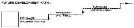
FIGURE 3: CARRYING DEVELOPMENT INTO THE FUTURE
A S S E S S M E N T
Departments: Architecture/Urban Planning/ Urban Local Body
Structural and Legal
Clarity of Vision and Mission
Funds
Laws
•
Land
Functions
Schemes
•
Urban Development
Functionaries
Techniques
•
Infrastructure Development
•
Business Development
•
Transport/ Road Network
•
Sustainability/ greens
•
Urban Poor
1.
Jobs
2.
Housing
3.
Services
•
Culture and Heritage
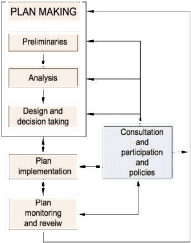
A broad framework for the methodology for preparation of the master plan is given in the figure below
FIGURE 4: PLAN MAKING PROCESS
iv.Developments shall be guided along desirable lines in the new areas. Organic pattern of villages where necessary shall be preserved and conserved / conservative surgery where unchecked growth has taken place shall be resorted to / development of villages shall take place as per notified Village Plans.
v. Chandigarh’s architecture shall preserve the vitality of all public and private buildings. Public open spaces shall be created as vibrant community spaces and the left out monuments envisaged by Le Corbusier shall be completed. Urban design shall be the guiding principle for improving the quality of inner and outer spaces.
vi. To make the city more green, more eco friendly, more people friendly, more walking and biking friendly. Mechanism of creating city forests shall be used for improving the micro environment and flora and fauna in the city.
vii. Due regard shall be given to preserve the bountiful natural heritage of forests, wild life sanctuary, green spaces and water bodies within and around the city.
Briefly , the challenge for Chandigarh is to frame strategies for Chandigarh’s growth aligned to the original principles adopted to the rapidly changing context. Though the metropolis today has fewer issues compared to other similar metropolitan cities, yet the immediate issues relate to: